
RZW EXEC: UNCERTAINTY IN T.S. LAURA FORECAST… RZW Exec partners, I hope you’re having a nice Friday. Below is a *highly detailed* explanation of where we are in the process of forecasting for Tropical Storm Laura, currently situated near the northernmost Leeward Islands. While the official forecast from the National Hurricane Center shows the potential for a hurricane to approach our local area next week, there is ample uncertainty in this idea. There is so much uncertainty that I’ve outlined 3 scenarios of what could happen below. Basically, we need the system to move westward and see if the center of circulation is going to be hindered drastically by Puerto Rico and Hispaniola before we can more accurately and precisely give more forecast details for what to expect locally.
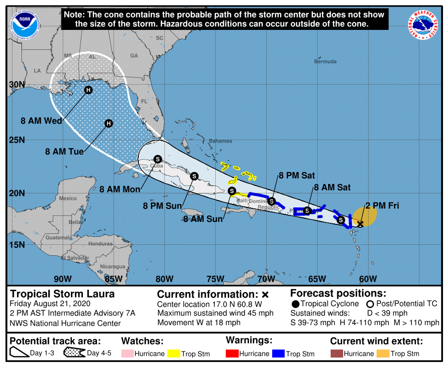
RANGE OF SCENARIOS FOR T.S. LAURA IMPACTS FOR GULF COAST… Tropical Storm Laura is rapidly moving west-northwest this evening. Today there has been somewhat of a notable shift in the projected path for Laura, with the center of circulation expected to be basically hugging the northern coastlines of Puerto Rico, Hispaniola, and Cuba this weekend. This complicates the forecast a bit more as it is unknown how weak or strong Laura will be AND if the system can actually hold together long enough to reach the Gulf of Mexico. You’re reading that correctly: There IS a chance this whole system fades away this weekend. On the higher end of the range of possibilities, there also is a chance Laura becomes a hurricane as it moves through The Bahamas this weekend and approaches South Florida and the Florida Keys. Beyond that point, there is yet another range of possibilities as to just how strong Laura will be as it turns northward in the eastern Gulf of Mexico and potentially approaches our local area by Tuesday of the upcoming week. Complicating matters even more are that we may have a hurricane on the OTHER side of the Gulf (TD14/Marco-to-be) that could slightly alter the projected path of Laura midweek. Our big takeaway as of Friday evening is that we still do not know specifics as to what will happen next week. We may have impacts from a hurricane locally, but there is still a significant chance that we won’t. Let’s look at what we know and what we don’t know.
POTENTIAL LOCAL IMPACTS FROM LAURA IN SOUTH ALABAMA & NW FLORIDA… Local impacts will be possible Tuesday, Wednesday, and early Thursday from what is currently Tropical Storm Laura. Forecast confidence remains unusually low, as we don’t know just yet how much land interaction will degrade the storm over the next few days. While local impacts will be possible, it is too early to suggest specifics for any city or town across our region. At a minimum, I expect gusty winds at the immediate coast and high surf & rip currents at local beaches. Depending on the exact future track of Laura, potential local impacts may have to be adjusted significantly. Direct local impacts from TD14/Marco appear unlikely.
SHORT TERM UNCERTAINTY MAGNIFIES UNCERTAINTY NEXT WEEK… There is good confidence in the short term that Tropical Storm Laura will continue to move west or perhaps just north of due west through tonight. The center of Laura as of 1PM is located at 17.0N and 60.8W. That is about 175 miles east-southeast of the northernmost Leeward Islands. Laura has not strengthened much today, but it did strengthen this morning JUST enough to become a named storm with 40 mph winds. Based on some of the personal accounts of the NOAA Hurricane Hunters that I follow on Twitter and Instagram, there was some question as to whether Laura still has a low-level center of circulation as of late morning. Drier air to the north and atmospheric shear (changing of wind direction with height in the atmosphere) continue to take a toll on Laura this afternoon. There IS a chance over the next 12-24 hours that Laura may open up into a tropical wave and fail to remain a tropical cyclone. Obviously if that particular scenario panned out, odds would be significantly higher that the land masses of Puerto Rico, Hispaniola and Cuba could severely disrupt the system or perhaps dissipate it entirely. You can tell that the low confidence I have in the short term NO DOUBT complicates forecast confidence exponentially in 3-5 days. Why? Because if we can’t definitively say what will happen in the next 24-72 hours, it is hard to have a “starting point” for a forecast that starts in 72 hours if that makes sense. Error in the short term compounds and enhances error in the long term. This remains a very, VERY uncertain forecast. As I indicated in our video last evening, I would imagine we will have a much better understanding of the short term variables by tomorrow (Saturday) morning.
GENERAL IDEA FOR LAURA: NORTHWESTERN MOVEMENT… The one thing I can communicate with high confidence today is the overall, general idea that Tropical Storm Laura will continue to move west or west-northwest over the next 2-3 days. There is very little doubt Laura will bring heavy rain at times to the U.S. and British Virgin Islands, Puerto Rico, the Dominican Republic, Haiti, the Turks & Caicos, The Bahamas and Cuba. If we “zoom out” and look at this situation with a broad view, there is a high degree of confidence that Laura (or perhaps what is left of Laura, in some scenarios) will end up in the southern Gulf of Mexico.
LOW CONFIDENCE IN INTENSITY FORECAST… Along the way over the next 2-3 days as Laura moves northwest, the storm may degenerate into an open tropical wave, it may remain a disorganized tropical storm or perhaps even weaken into a tropical depression, OR if the center of circulation can reform to the north of the Greater Antilles, it may rapidly strengthen into a hurricane this weekend as it rapidly moves northwest. So again (just to drive this point home), Laura may be a weak area of low pressure, tropical depression, tropical storm, or hurricane once the storm reaches the Florida Keys and Florida Straits this weekend.
IMPACTS *LIKELY* IN FLORIDA KEYS… Impacts from Tropical Storm Laura are likely in the Florida Keys and parts of the southern part of Florida regardless of how strong the storm is early next week. Heavy rain, high winds, isolated tornadoes, storm surge, high surf, and flash flooding will all be concerns. Confidence is now high that the Keys could potentially have a range of impacts from Laura from early Monday morning through early Tuesday morning.
RANGE OF LAURA OUTCOMES BELOW… Clearly, the forecast for Tropical Storm Laura has short-term and long-term intricacies that complicate the forecast for this system. Unfortunately, other than the Florida Keys, Greater Antilles, and The Bahamas, we cannot conclusively say who will have impacts along the Gulf Coast region and who won’t. Below are THREE scenarios (a best case, a most likely as of this moment, and a worst case) we can look at to understand the range of impacts for our local area in south Alabama and northwest Florida.
BEST CASE SCENARIO – LAURA… The absolute best case scenario would be for Tropical Storm Laura to be absolutely destroyed and hammered by the high terrain of Puerto Rico, Hispaniola, and western Cuba. These islands have destroyed many a tropical storm and hurricane over the years and our best case scenario shows Laura degenerating into a remnant low tropical wave as it moves northwest toward the Gulf of Mexico. If what is left of Laura at that point emerges fractured and weak, the system won’t have as long of a time to strengthen before the system moves into the northern Gulf, somewhere between Texas and the Florida Panhandle next week. It is important to note that even in this best case scenario, Laura could be significantly degraded, emerge over the southeastern Gulf early next week, and then rapidly strengthen into a hurricane before landfall sometime in the middle of the week.
MOST LIKELY SCENARIO – LAURA… The official forecast from the National Hurricane Center paints a good picture of the most likely scenario, as 3PM on Friday. NHC calls for the center of Tropical Storm Laura to basically be right on top of the northern coastlines of Puerto Rico, Hispaniola, and Cuba. This partial land interaction will likely, at minimum, keep the strengthen of the storm steady and not allow for rapid intensification in the short term. Beyond this, model guidance has continued to trend farther WEST over the last 12-24 hours, meaning there is a good chance the NHC projected path (cone of uncertainty) will also shift a bit farther west in future advisories. While this could potentially signify good news for our local area, potentially avoiding the direct hit of a hurricane, two important caveats here: 1) It is FAR too early to say conclusively our local area won’t have direct impacts. Please don’t let your guard down this weekend. 2) EVEN IF the system moves inland farther west from us directly, that puts the entirety of our local area on the volatile eastern flank of the storm. Isolated tornadoes, gusty winds the immediate coast, storm surge, high surf, heavy rain, and flash flooding would all be concerns under this most likely scenario. The most likely scenario will change in the days ahead as we receive more data.
WORST CASE SCENARIO – LAURA… This worst case scenario is designed for south Alabama and northwest Florida. Keep in mind that a worst case scenario USUALLY does not happen in situations like this. This is one possibility in a range of possibilities. The worst case scenario basically would keep the center of circulation of Laura north of Puerto Rico, Hispaniola, and Cuba over the next 2-3 days with the system rapidly strengthening into a hurricane or perhaps a major hurricane as it approaches the Florida Keys and the Florida Straits. Once the system emerges into the Gulf as a formidable hurricane that hasn’t really been affected by much in the way of land areas, there could be a clear path to further strengthening. The system could ramp up to a powerful, major hurricane in the Gulf before approaching a northern Gulf Coast landfall sometime in the middle of the upcoming week. Local impacts for our area in that scenario, depending on the exact future track of Laura, could be extensive. Again, this remains an OUTLIER scenario as of now, but I feel it is important to communicate the RANGE of possibilities.
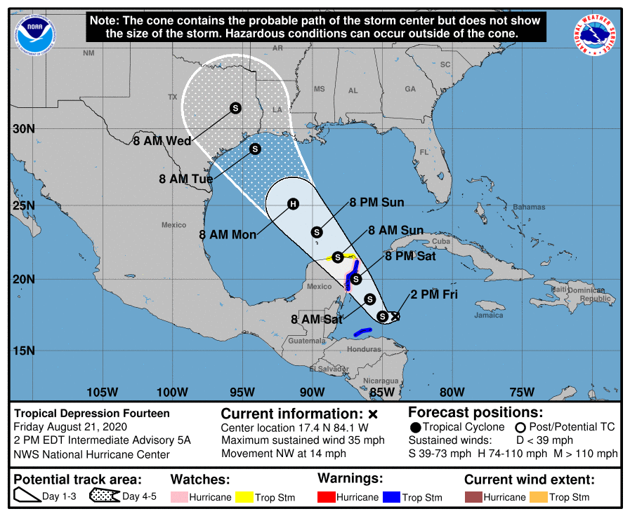
LET’S NOT FORGET ABOUT TD14/MARCO… Complicating the forecast for Tropical Storm Laura even more are the fact that models are dealing with another developing tropical depression in the western Caribbean Sea. I would suggest there is a very high chance Tropical Depression 14 will be upgraded tonight to Tropical Storm Marco, based on the latest visible satellite imagery. We will get more Hurricane Hunter aircraft recon data from the system later this evening. TD14/Marco will move northwest in the days ahead, likely crossing the northern part of the Yucatan Peninsula of Mexico Saturday night into Sunday. A Hurricane Watch and Tropical Storm Warning continue for parts of the Yucatan near Cancun. Once TD14/Marco emerges into the southern Gulf on Sunday, strengthening will likely commence. NHC ramps the system up to a category 1 hurricane in the west-central Gulf before weakening begins Monday night into Tuesday as southwesterly shear kicks in. Landfall of TD14/Marco will likely happen somewhere along the Texas or Louisiana coast. Right now, the cone of uncertainty extends from Corpus Christi, TX to Morgan City, LA. This includes Houston, Galveston, Beaumont, Lake Charles, and Lafayette (LA). These areas should be on guard for the potential for tropical storm or hurricane impacts starting as early as late Monday night, extending through Tuesday.
APP ALERTS… If you haven’t already downloaded the RedZone Weather app, now is a great time to do that. redzoneweather.com/app is the link to the free download. Once you have the RZW app installed on your iOS or Android device, be sure to visit the Alerts tab to turn on the specific notifications you’d like to receive. All notifications are handcrafted by me. No automation and we promise not to bug you!
NEXT UPDATE… I will have another detailed post later this evening. Have a great Friday evening!