
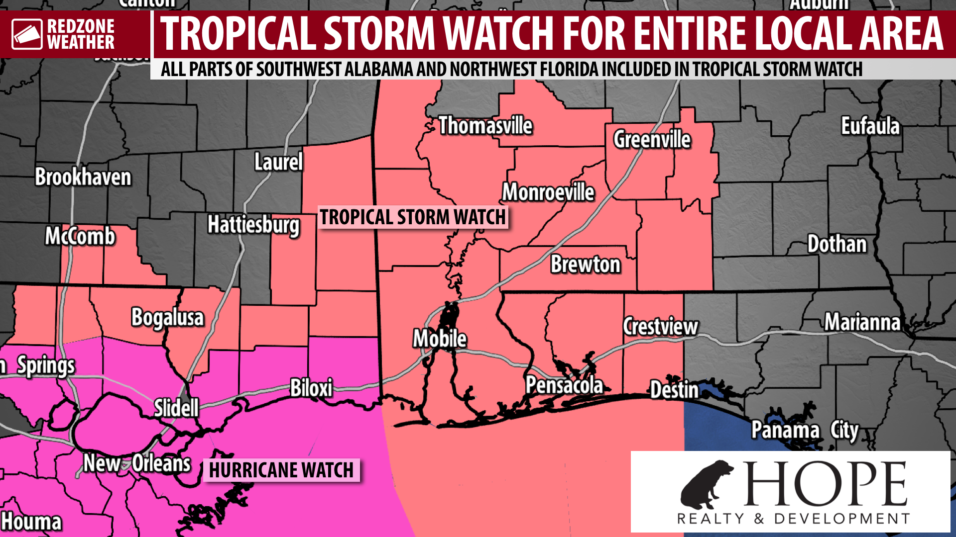
TROPICAL STORM WATCH FOR ENTIRE LOCAL AREA AHEAD OF ZETA… Hurricane Zeta has prompted a Tropical Storm Watch for the entire local area in southwest Alabama and northwest Florida. No matter if you are inland or along the coast, you are now involved in a Tropical Storm Watch. This means that tropical storm force wind gusts (in excess of 39 mph) may be possible across the entirety of our local area. There also is a Hurricane Watch is in effect from Morgan City, Louisiana eastward to the Alabama-Mississippi state line including several counties in Mississippi and Louisiana. The Tropical Storm Watch is in effect from the Alabama-Mississippi state line eastward to Miramar Beach, Florida.
LANDFALL OF ZETA LIKELY ON WEDNESDAY EVENING… The cone of uncertainty for the northern Gulf Coast now extends from Morgan City, Louisiana eastward to Navarre, Florida. A landfall point in southeast Louisiana seems most likely, but further jogs to the east or west may be possible in the hours ahead. Emphasis: The landfall POINT is one point on the map. Impacts WILL extend well outward from the center of circulation and our local area is slated to be on the volatile eastern side of this storm as it passes.
The following information from my previous post earlier this afternoon remains on target. Next live video this evening!
POTENTIAL LOCAL IMPACTS – ZETA… Heavy rain and tornadoes will probably end up being the greatest impacts from Zeta for our local area in south Alabama and northwest Florida. Gusty winds will also be possible near the Alabama and northwest Florida beaches. All coastal hazards are possible as well, including rip currents, high waves, coastal flooding, and storm surge. Fortunately, there continues to be high confidence Zeta will be accelerating northeast by the middle of the week, meaning widespread extreme river and creek flooding (like what we saw with Hurricane Sally several weeks ago) is currently NOT expected.
UPDATED TIMING OF LOCAL ZETA IMPACTS… The overall timeline of expected impacts from Hurricane Zeta has been moved to be a bit later. Noon Wednesday to Noon Thursday will be the 24 hour window when potential local impacts from Tropical Storm Zeta will be MOST likely to happen across south Alabama and northwest Florida. The latest guidance suggests 8PM Wednesday to 4AM on Thursday will be the 8 hour window when impacts will be most likely to happen locally across south Alabama and northwest Florida.
LIVE VIDEO THIS EVENING… We will “go live” on Facebook at some point this evening between 7PM and 9:30PM. Until then, plenty more updates will be posted in the RedZone Weather app.
APP ALERTS… redzoneweather.com/app is the link where you can download the free RedZone Weather app. We post brief updates throughout each day in the app, keeping you up-to-date about the latest happenings in weather across south Alabama and northwest Florida. Once you have the free app downloaded to your iOS or Android device, be sure to visit the Alerts tab (lower right corner) then tap the large, yellow Alert Settings button to customize the alerts you would like to receive straight from me.
Have a good Monday evening!