
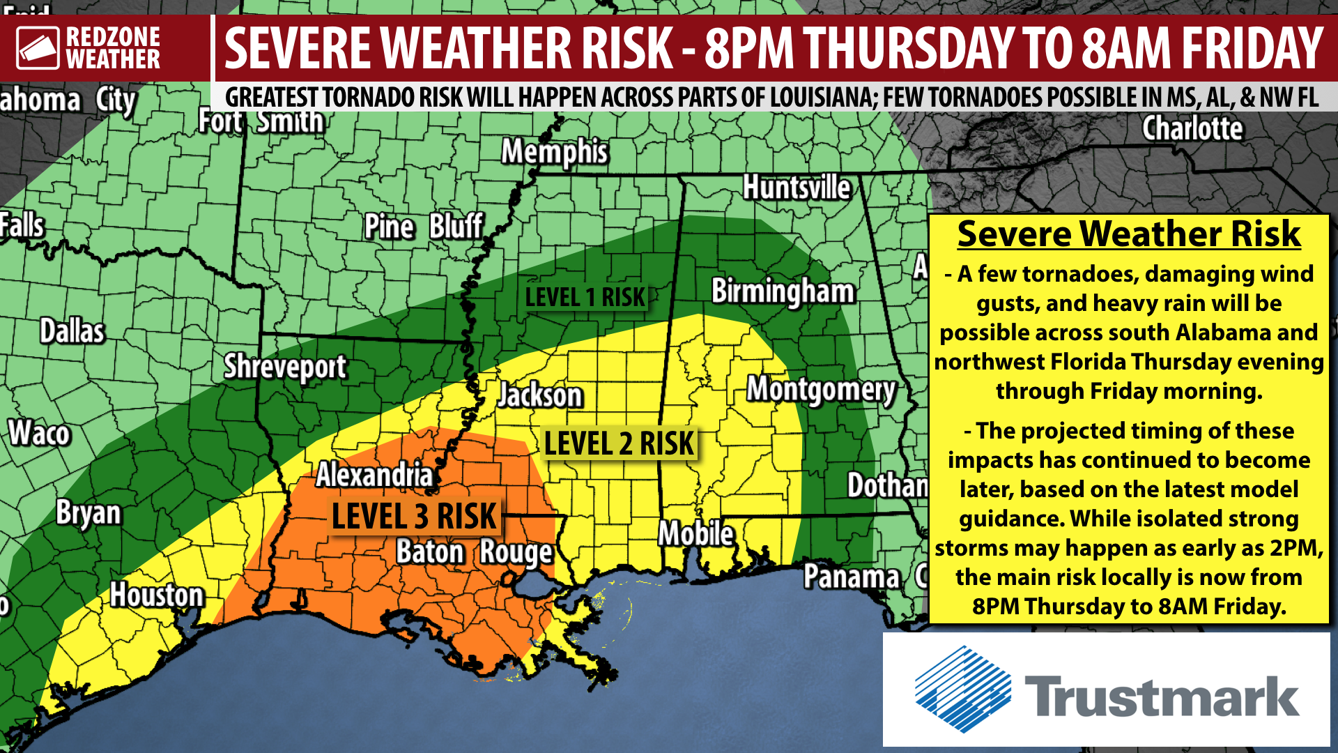
SEVERE WEATHER RISK LIKELY TO BE A BIT LATER; LEVEL 2 (OUT OF 5) RISK LOCALLY… The overall chance of severe storms has trended later and now will be from 8PM on Thursday to 8AM on Friday across southwest Alabama and northwest Florida. While a few strong to severe storms can’t be ruled out completely in the afternoon hours of Thursday, it seems clear based on new model guidance that continues to come in that the overall risk will be greatest in the overnight hours. Vast majority of our local area remains involved in a Level 2 (out of 5) severe weather risk, meaning scattered severe storms (including tornadoes and damaging wind gusts) will be possible. Rain could be heavy at times tomorrow night, including in some areas at midnight when the New Year begins.
A NOTE ABOUT DISCERNING WHEN STORMS WILL HAPPEN… Normally ahead of severe weather events, the way it works is we sample a lot of different weather models that usually have differences in timing, intensity of storms, etc. Normally, we see a convergence (or coming together) of model data across different models. This leads to higher confidence in the overall setup. This time, however, models continue to have an anomalously large spread in terms of timing of storms. Now that you know how that process works a bit better as to how we discern storm timing AND knowing that storm timing confidence is a bit lower for this particular event, see more information about the severe weather timing below.
SEVERE WEATHER TIMING – THURSDAY INTO FRIDAY… Showers could happen overnight into Thursday morning. A gradual increase in rain chances is expected late morning. Isolated strong to marginally severe thunderstorms may happen as early as 2PM tomorrow (Thursday). Our 12 hour window for when strong to severe storms seem most likely to happen across south Alabama and northwest Florida has shifted to be a bit later, now extending from 8PM Thursday to 8AM Friday. Just to be clear, a few strong to severe storms may be possible as early as 2PM, with the main window for severe storms kicking off at 8PM and extending to 8AM Friday.
WHAT TO EXPECT – TONIGHT INTO THURSDAY MORNING… No hazardous weather is expected tonight or in the early morning hours of Thursday. There could be a few showers around at times overnight. Most of us will remain dry, however. Rain chances will gradually increase in the late morning and early afternoon hours of Thursday.
LOW-END SEVERE WEATHER RISK SETS UP THURSDAY AFTERNOON… We will need to closely monitor any showers and thunderstorms that pop up on Thursday afternoon, primarily after 2PM, as some of these storms could be strong or even briefly severe. While the overall tornado risk will ramp up after 8PM, gusty winds and a tornado or two can’t completely be ruled out in the afternoon hours. Most of the severe weather issues on Thursday afternoon are expected to be to our west across parts of Louisiana and Mississippi.
MAIN SEVERE WEATHER EVENT – THURSDAY EVENING INTO FRIDAY MORNING… Storms will likely merge into a QLCS (squall line) on Thursday evening and push toward west Alabama. There also could be a few discrete, isolated storms out ahead of this main line of storms that could become severe on Thursday night into Friday morning. The main line of storms will progressively move eastward across our region through the early morning hours of Friday.
UPDATE ON NEW YEAR’S EVE CELEBRATIONS… There remains a high chance that most locales across our region will have rain and thunderstorms around close to midnight tomorrow night as we ring in the New Year. Temperatures will be in the upper-60s around midnight with plenty of humidity in place, even in areas where rain is not happening at the moment of midnight. I know many more folks compared to normal will be on local roads traveling due to New Year’s Eve celebrations. Please keep tabs on the developing weather situation and know where you would go and what you would do if a tornado warning becomes required for your location. If we have tornado warnings going on at midnight, we will be in studio bringing you uninterrupted live streaming coverage.
HAVE A WAY TO GET WARNINGS THURSDAY NIGHT… While the overall tornado risk is set to be higher to our west across parts of southwest Mississippi and Louisiana, tornadoes and damaging wind gusts remain possible across our local area in south Alabama and northwest Florida. Please have a way (or preferably multiple ways!) to get urgent weather warnings BEFORE you go to sleep tomorrow night.
COASTAL FLOODING POSSIBLE THURSDAY NIGHT… The local National Weather Service is highlighting the potential for a strong onshore flow on Thursday evening that could lead to coastal flooding in low-lying areas, especially on/near Mobile Bay, but also including other bays and local shorelines.
TORNADO WARNING POLICY… Any time there is an active tornado warning in effect for southwest Alabama or northwest Florida, we provide uninterrupted, live video coverage on Facebook Live and in the RedZone Weather app. Our detailed coverage commitment is outlined at redzoneweather.com/coverage. We are proud to cover all parts of Escambia (AL), Covington, Monroe, Conecuh, Baldwin, Mobile, Clarke, Washington, Butler, Escambia (FL), Santa Rosa, and Okaloosa counties. If you live in any locale in those counties, be sure to tune into our coverage whenever there is an active tornado warning!
SET UP APP ALERTS… We send quite a bit of Low-Level Alerts in our RedZone Weather app. The app is totally free for you! redzoneweather.com/app is the link where you see the download links to your respective app store for iOS and for Android devices. Once you have the app downloaded to your smartphone or tablet device, be sure to visit the Alerts tab to customize the alerts you would like to receive straight from me.
NEXT UPDATE… I will have your next full forecast video posted by 7:15AM tomorrow morning. Have a good Wednesday evening!