Tap below to support this RZW sponsor!


SEVERE STORMS POSSIBLE LATER TODAY INTO THE OVERNIGHT HOURS… Severe storms will become possible later today as a squall line approaches south Alabama and northwest Florida from the west. There could be isolated, discrete storms that form out ahead of the main line of storms that could be potentially severe. Showers will be possible at times this morning into the early afternoon hours. Isolated severe storms could start as early as 2PM. Most of the severe weather issues, however, will happen from 8PM this evening to 8AM on New Year’s Day Friday. There is a high probability that some, if not most, New Year’s Eve celebrations across our region will be wet this evening with quite a bit of rain around. Please have a way to hear warnings tonight and take action to protect yourself and your loved ones if a warning is required for your specific location. If tornado warnings are needed locally, we will go into our nonstop live video coverage to bring you the latest information. More Thursday morning forecast details are below.
SHOWERS POSSIBLE THROUGH EARLY AFTERNOON… Areas of light to moderate rain will increase in coverage over the next several hours across the region. Rain chances will gradually increase throughout the day. High temperatures this afternoon will be way too warm for late December with most spots peaking in the mid-70s.
LOW-END RISK OF STRONG STORMS FROM 2PM TO 8PM… Isolated thunderstorms may happen this afternoon, especially closer to the Alabama and northwest Florida beaches. Some of these storms may briefly become strong or even marginally severe. The overall tornado risk ramps up tonight after sunset, but I cannot completely rule out the possibility of a tornado or gusty winds this afternoon. I expect most spots to just have intermittent showers this afternoon, however.
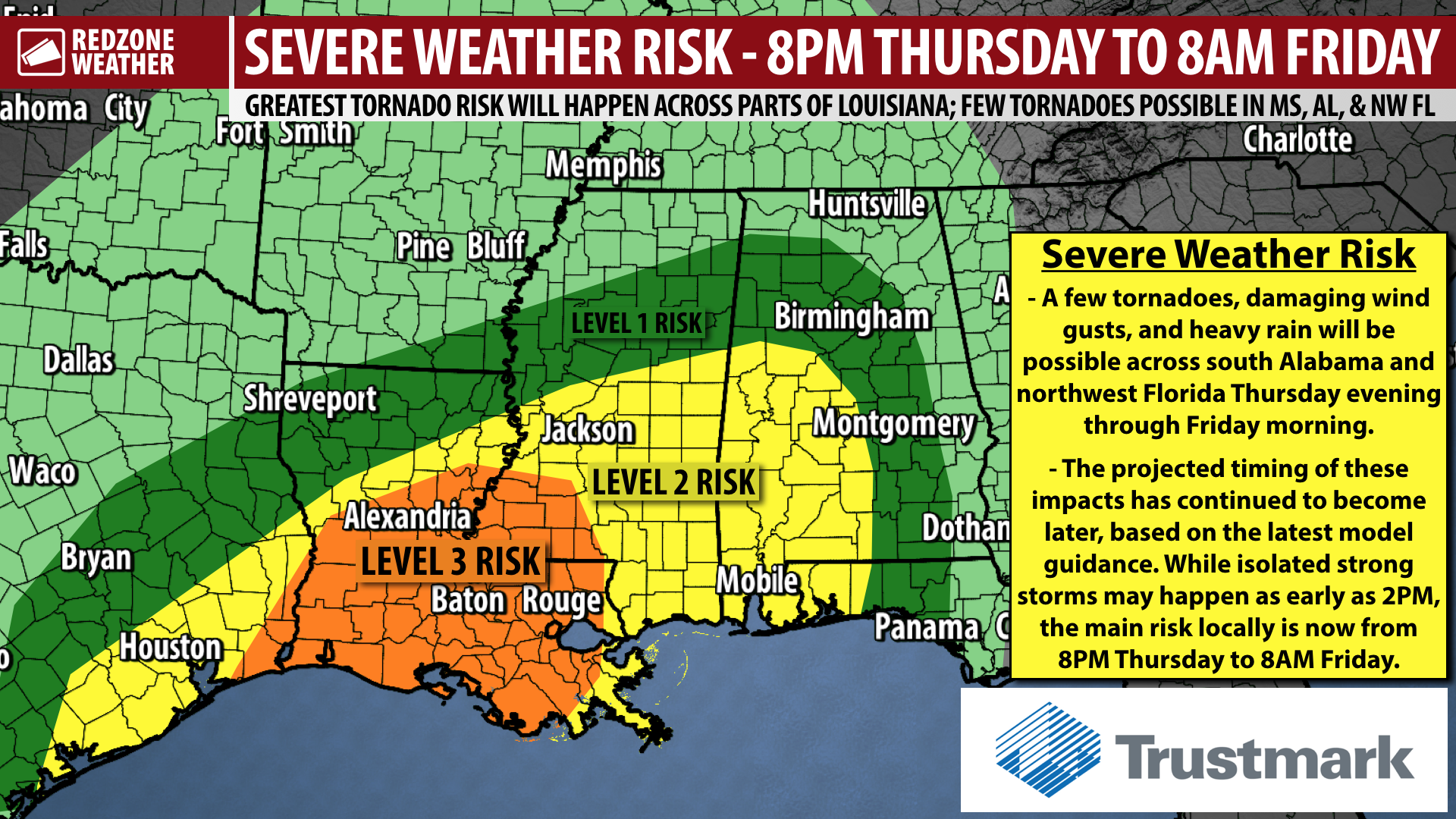
MAIN SEVERE WEATHER RISK – 8PM TONIGHT TO 8AM FRIDAY… Severe weather hazards are most likely to happen tonight when we have the “greatest mixture” of surface-based instability, atmospheric shear, and moisture in place across the region. We’ll be watching a developing squall line/QLCS develop to our west today. This line of storms will cross our region in the overnight hours. The concern is that some of the storms out ahead of this line of storms could be severe. Tornadoes will be possible. In addition, damaging “straight line” winds are also possible in the stronger storms that fire up and of course in the main line of storms. Rain could be quite heavy at times, and flash flooding is a possibility if storms begin training over the same areas.
TORNADO RISK GREATEST TO OUR WEST TODAY… Before we get to our main severe weather time frame later this evening, we will be watching storms firing to our west. The Storm Prediction Center continues to include much of Louisiana and southwestern Mississippi in their Level 3 (out of 5) enhanced severe weather risk zone. This risk zone is driven by a higher tornado probability. This Level 3 risk zone includes places like New Orleans, Baton Rouge, Lafayette, Alexandria, Lake Charles, Fort Polk, Cameron, Hammond, New Iberia, and Houma in Louisiana.
LEVEL 2 (OUT OF 5) RISK FOR MUCH OF OUR AREA… The severe weather risk zones have not changed that much since last evening. The risk zones for our area have been quite consistent in the lead up to this severe weather potential. The Storm Prediction Center continues to include much of our area in their Level 2 (out of 5) severe weather risk zone valid for this evening into early Friday. Locally, this zone includes areas along and WEST of a line from Forest Home to Georgiana to Wing to Navarre. This means the following communities are involved in the Level 2 risk zone (where scattered severe storms may happen Thursday into Thursday night): Mobile, Pensacola, Milton, Pace, Gulf Breeze, Molino, Warrington, Perdido Key, Walnut Hill, Bratt, Century, Jay, Berrydale, Munson, Whiting Field, Holt, Harold, Bay Minette, Perdido, Stockton, Stapleton, Daphne, Fairhope, Spanish Fort, Montrose, Gulf Shores, Orange Beach, Foley, Magnolia Springs, Elberta, Loxley, Gateswood, Bayou La Batre, Coden, Dauphin Island, Theodore, Wilmer, Prichard, Saraland, Satsuma, Creola, Mt. Vernon, Citronelle, Chunchula, Brewton, Atmore, Flomaton, Poarch, Huxford, Damascus, Riverview, Castleberry, Evergreen, Repton, Range, Owassa, Lyeffion, Monroeville, Uriah, Beatrice, Tunnel Springs, Peterman, Excel, Frisco City, Perdue Hill, Grove Hill, Thomasville, Jackson, Coffeeville, Millry, Chatom, Yarbo, Wagerville, McIntosh, Greenville, Georgiana, McKenzie, and surrounding areas.
LEVEL 1 RISK FARTHER EAST… Much of Covington and Okaloosa counties are involved in the lower, Level 1 (out of 5) marginal severe weather risk where strong storms are not as likely to happen, but still possible. This includes places like Andalusia, Opp, Florala, Straughn, Horn Hill, Crestview, Destin, and Niceville.
RAIN MOVES OUT FRIDAY MIDDAY… Rain and storms will exit our area to the east late tomorrow morning, extending into the early afternoon hours for the eastern half of our area. Gusty winds (15-25 mph) will be possible before and after the main line of thunderstorms passes through a given area. Rain chances will be much lower tomorrow evening, but not completely at zero. There still could be a few showers around Friday evening into Friday night.
FEW SHOWERS POSSIBLE SATURDAY MORNING… Isolated showers may happen along, south, and east of Interstate 65 on Saturday, primarily in the morning hours. The severe weather risk will be well to our east on Saturday, but a few areas of rain will be possible. Cooler, drier air will move in Saturday afternoon. Highs on Saturday will be in the mid-60s.
QUIET, COOL WEATHER AHEAD FOR EARLY NEXT WEEK… Sunshine returns in full force on Sunday. High temperatures will only be in the mid- to upper-50s on Sunday. Temperatures quickly rebound into the 60s by Monday. Right now, mostly sunny skies are expected Sunday through at least Wednesday morning of the upcoming week.
TORNADO WARNING POLICY… Any time there is an active tornado warning in effect for southwest Alabama or northwest Florida, we provide uninterrupted, live video coverage on Facebook Live and in the RedZone Weather app. Our detailed coverage commitment is outlined at redzoneweather.com/coverage. We are proud to cover all parts of Escambia (AL), Covington, Monroe, Conecuh, Baldwin, Mobile, Clarke, Washington, Butler, Escambia (FL), Santa Rosa, and Okaloosa counties. If you live in any locale in those counties, be sure to tune into our coverage whenever there is an active tornado warning!
APP ALERTS… We send quite a bit of Low-Level Alerts in our RedZone Weather app. The app is totally free for you! redzoneweather.com/app is the link where you see the download links to your respective app store for iOS and for Android devices. Once you have the app downloaded to your smartphone or tablet device, be sure to visit the Alerts tab to customize the alerts you would like to receive straight from me.
I will have updates posted throughout the day and into tonight in the RedZone Weather app. If or when tornado warnings become required for our local area, be sure to join me for live streaming video coverage. Have a great New Year’s Eve Thursday, stay dry, and stay safe!

⛈ Thunderstorms will be increasingly likely later today and into the overnight hours. Some of the storms may be strong or severe. Tornadoes possible tonight.
Please keep tabs on the local weather situation, especially if you're headed out to a New Year's Eve celebration. pic.twitter.com/qHRrCeifv9
— Spinks Megginson (@rzweather) December 31, 2020

? Please have a way to get urgent weather warnings today into tonight if you're involved in the expansive severe weather risk zones today into tonight.
Severe storms possible in parts of east Texas, Louisiana, Mississippi, Alabama, and northwest Florida. pic.twitter.com/QlA03V2e3R
— Spinks Megginson (@rzweather) December 31, 2020

No real changes in the overall thinking from SPC early this morning… Much of our area remains involved in the Level 2 (out of 5) severe weather risk valid for later today into tonight.
Level 3 (out of 5) enhanced risk for parts of SW Mississippi and Louisiana. pic.twitter.com/LDJjbHczFR
— Spinks Megginson (@rzweather) December 31, 2020

⚠️? NW FL Panhandle beaches upgraded to a High Surf Warning for surf heights of 8-10 feet Thurs. night – Friday morning
High Surf Advisory continues along AL beaches for surf heights of 5-8 feet
HIGH #RipCurrent RISK remains in effect for ALL area beaches#alwx #flwx #beachwx pic.twitter.com/5smotmD35p
— NWS Mobile (@NWSMobile) December 31, 2020

SEVERE WEATHER RISK LIKELY TO BE A BIT LATER; LEVEL 2 (OUT OF 5) RISK LOCALLY… The overall chance of severe storms has trended later and now will be from 8PM on Thursday to 8AM on Friday across southwest Alabama and northwest Florida. While a few strong to severe storms can’t be ruled out completely in the afternoon hours of Thursday, it seems clear based on new model guidance that continues to come in that the overall risk will be greatest in the overnight hours. Vast majority of our local area remains involved in a Level 2 (out of 5) severe weather risk, meaning scattered severe storms (including tornadoes and damaging wind gusts) will be possible. Rain could be heavy at times tomorrow night, including in some areas at midnight when the New Year begins.
A NOTE ABOUT DISCERNING WHEN STORMS WILL HAPPEN… Normally ahead of severe weather events, the way it works is we sample a lot of different weather models that usually have differences in timing, intensity of storms, etc. Normally, we see a convergence (or coming together) of model data across different models. This leads to higher confidence in the overall setup. This time, however, models continue to have an anomalously large spread in terms of timing of storms. Now that you know how that process works a bit better as to how we discern storm timing AND knowing that storm timing confidence is a bit lower for this particular event, see more information about the severe weather timing below.
SEVERE WEATHER TIMING – THURSDAY INTO FRIDAY… Showers could happen overnight into Thursday morning. A gradual increase in rain chances is expected late morning. Isolated strong to marginally severe thunderstorms may happen as early as 2PM tomorrow (Thursday). Our 12 hour window for when strong to severe storms seem most likely to happen across south Alabama and northwest Florida has shifted to be a bit later, now extending from 8PM Thursday to 8AM Friday. Just to be clear, a few strong to severe storms may be possible as early as 2PM, with the main window for severe storms kicking off at 8PM and extending to 8AM Friday.
WHAT TO EXPECT – TONIGHT INTO THURSDAY MORNING… No hazardous weather is expected tonight or in the early morning hours of Thursday. There could be a few showers around at times overnight. Most of us will remain dry, however. Rain chances will gradually increase in the late morning and early afternoon hours of Thursday.
LOW-END SEVERE WEATHER RISK SETS UP THURSDAY AFTERNOON… We will need to closely monitor any showers and thunderstorms that pop up on Thursday afternoon, primarily after 2PM, as some of these storms could be strong or even briefly severe. While the overall tornado risk will ramp up after 8PM, gusty winds and a tornado or two can’t completely be ruled out in the afternoon hours. Most of the severe weather issues on Thursday afternoon are expected to be to our west across parts of Louisiana and Mississippi.
MAIN SEVERE WEATHER EVENT – THURSDAY EVENING INTO FRIDAY MORNING… Storms will likely merge into a QLCS (squall line) on Thursday evening and push toward west Alabama. There also could be a few discrete, isolated storms out ahead of this main line of storms that could become severe on Thursday night into Friday morning. The main line of storms will progressively move eastward across our region through the early morning hours of Friday.
UPDATE ON NEW YEAR’S EVE CELEBRATIONS… There remains a high chance that most locales across our region will have rain and thunderstorms around close to midnight tomorrow night as we ring in the New Year. Temperatures will be in the upper-60s around midnight with plenty of humidity in place, even in areas where rain is not happening at the moment of midnight. I know many more folks compared to normal will be on local roads traveling due to New Year’s Eve celebrations. Please keep tabs on the developing weather situation and know where you would go and what you would do if a tornado warning becomes required for your location. If we have tornado warnings going on at midnight, we will be in studio bringing you uninterrupted live streaming coverage.
HAVE A WAY TO GET WARNINGS THURSDAY NIGHT… While the overall tornado risk is set to be higher to our west across parts of southwest Mississippi and Louisiana, tornadoes and damaging wind gusts remain possible across our local area in south Alabama and northwest Florida. Please have a way (or preferably multiple ways!) to get urgent weather warnings BEFORE you go to sleep tomorrow night.
COASTAL FLOODING POSSIBLE THURSDAY NIGHT… The local National Weather Service is highlighting the potential for a strong onshore flow on Thursday evening that could lead to coastal flooding in low-lying areas, especially on/near Mobile Bay, but also including other bays and local shorelines.
TORNADO WARNING POLICY… Any time there is an active tornado warning in effect for southwest Alabama or northwest Florida, we provide uninterrupted, live video coverage on Facebook Live and in the RedZone Weather app. Our detailed coverage commitment is outlined at redzoneweather.com/coverage. We are proud to cover all parts of Escambia (AL), Covington, Monroe, Conecuh, Baldwin, Mobile, Clarke, Washington, Butler, Escambia (FL), Santa Rosa, and Okaloosa counties. If you live in any locale in those counties, be sure to tune into our coverage whenever there is an active tornado warning!
SET UP APP ALERTS… We send quite a bit of Low-Level Alerts in our RedZone Weather app. The app is totally free for you! redzoneweather.com/app is the link where you see the download links to your respective app store for iOS and for Android devices. Once you have the app downloaded to your smartphone or tablet device, be sure to visit the Alerts tab to customize the alerts you would like to receive straight from me.
NEXT UPDATE… I will have your next full forecast video posted by 7:15AM tomorrow morning. Have a good Wednesday evening!

The overall timing for the severe weather setup has continued to trend LATER.
Main window for severe storms across south Alabama & NW Florida will be 8PM Thursday to 8AM Friday. Could have a few strong storms in the afternoon hours of Thursday. Details: https://t.co/li9dLGNc5i pic.twitter.com/Fx0AyUXRf3
— Spinks Megginson (@rzweather) December 31, 2020

Gorgeous sunset in Red Level, AL this evening ahead of possible storms over the next few days. #alwx @NWSMobile @rzweather @TaylorSarallo @ThomasGeboyWX @JoshWeather pic.twitter.com/rGGpc3sAIr
— KJ Davis (@galaxyclasskj) December 31, 2020

It’s a beautiful afternoon across the region. Temperatures have climbed into the low-70s in many spots. ? pic.twitter.com/C7aH0vnX5X
— Spinks Megginson (@rzweather) December 30, 2020

There is an enhanced risk of severe weather from far SE TX across LA and into SW MS. All severe weather hazards are expected including the potential for tornadoes. Stay tuned to the latest weather forecast and your local NWS forecast office for additional information. pic.twitter.com/Nsn8Onl1SX
— NWS Storm Prediction Center (@NWSSPC) December 30, 2020

We are flying single red flags in Orange Beach today – Wednesday, December 30th. Single red flags represent a high risk of rough surf and dangerous rip currents. Here is the morning view from Cotton Bayou Beach. @spann #alwx pic.twitter.com/fFhGPcrRyE
— City of Orange Beach (@cityorangebeach) December 30, 2020
The Storm Prediction Center maintains most of our local area in the Level 2 (out of 5) risk zone valid for Thursday into early Friday.
Level 3 (enhanced) risk added for much of Louisiana, extreme SE Texas, and SW Mississippi. pic.twitter.com/B6Q5tQgHBH
— Spinks Megginson (@rzweather) December 30, 2020
Wednesday sunrise in Orange Beach. @spann @Kyle_WPMI @michaelwhitewx @WeatherBrooke @WEARKDaniel @rzweather @Kelly_WPMI @TaylorSarallo @NWSMobile @weswyattweather @ThomasGeboyWX pic.twitter.com/AtRNO5vUzl
— Jimmy Sarris (@sarrisjp) December 30, 2020
Cooler temps arrive this weekend, but not before a round of active weather. Severe storms possible Thursday into Thursday night.
Please have a way to get urgent weather warnings tomorrow. Certainly not good to have this happening on New Year's Eve… pic.twitter.com/2hgOX87IqP
— Spinks Megginson (@rzweather) December 30, 2020


RAIN & STORMS AT TIMES THURSDAY INTO THURSDAY NIGHT; INCREASING CLOUDINESS TODAY… Heavy rain and strong to severe thunderstorms are expected at times Thursday evening into early Friday morning as a cold front approaches from the west. The Storm Prediction Center continues to include our area in severe weather risk zones, suggesting the potential for tornadoes, damaging winds, and heavy rain at times that could lead to flash flooding. The main time frame for severe storms will be from 4PM Thursday to 4AM Friday. We will go into nonstop live video coverage if and when tornado warnings are required for our local area (even if a warning is happening at midnight when 2021 starts!). You’ll notice more in the way of cloud cover on this Wednesday with temperatures that are too warm for late December, climatologically speaking. High temperatures will be in the low-70s by 2PM. Looking ahead to New Year’s Day on Friday and into the weekend, we could have some lingering showers on Friday. A few showers may also become possible on Saturday morning. Sunday and Monday will trend drier and colder.
PARTLY CLOUDY TODAY; WARM FOR LATE DECEMBER… Increasing cloudiness is expected across the region on this Wednesday. High temperatures will peak in the 71-74° range this afternoon, which is approximately 15 degrees above our climatological normal high temperature for late December. Get out and enjoy the warm, nice weather today if you can. Today will be the warmest day out of the next 7 days.
A FEW SHOWERS POSSIBLE OVERNIGHT INTO THURSDAY MORNING… There could be a few showers as early as this evening into the overnight hours. Most of the rain will happen on Thursday into early Friday, however. We’ll call it a 30% chance of showers after midnight tonight extending into the early morning hours of Thursday. Overnight lows will be in the mid-50s by Thursday morning around 6AM.
RAIN & STORMS BECOME MORE NUMEROUS THURSDAY AFTERNOON… Rain chances will gradually increase throughout the day on Thursday. There is a chance some spots will remain dry through the afternoon and early evening hours, but I expect rain to spread across the region especially near and after sunset on Thursday. High temperatures Thursday will be in the mid-70s. The southeasterly wind will really bring up humidity levels on Thursday evening, paving the way for the severe weather risk.
SEVERE WEATHER RISK THURSDAY EVENING INTO FRIDAY EARLY MORNING… The 12 hour window when severe storms seem most likely to happen across southwest Alabama and northwest Florida is from 4PM Thursday to 4AM Friday. This time frame includes a big chunk of the overnight hours, meaning we all should have a way (or better yet, multiple ways!) to get urgent weather warnings before we go to sleep Thursday night. I will not be sleeping Thursday night as we will be in studio all night long bringing you the latest information until the severe weather threat ends. We will “go live” for any tornado warnings that are issued locally. See redzoneweather.com/coverage for our detailed coverage policy.
NEW YEAR’S EVE CELEBRATIONS LIKELY TO HAVE RAIN AROUND… Unfortunately, rain and storms will be increasingly likely as we approach midnight on Thursday night. This means there is a high chance many local New Year’s Eve celebrations will have rain and storms around. I (nor anyone else) can pinpoint exactly where storms will be firing around midnight, but there is a high chance we will have a line of strong to severe storms moving across our region at that point. If, by chance, we have active tornado warnings going on across our local area at midnight as 2021 begins, we will be in live video coverage (per our normal).
LEVEL 2 (OUT OF 5) RISK FOR MUCH OF OUR AREA… The severe weather risk zones have not changed that much since last night. The Storm Prediction Center continues to include much of our area in their Level 2 (out of 5) severe weather risk zone valid for Thursday into early Friday. Locally, this zone includes areas along and WEST of a line from Forest Home to Georgiana to Wing to Navarre. This means the following communities are involved in the Level 2 risk zone (where scattered severe storms may happen Thursday into Thursday night): Mobile, Pensacola, Milton, Pace, Gulf Breeze, Molino, Warrington, Perdido Key, Walnut Hill, Bratt, Century, Jay, Berrydale, Munson, Whiting Field, Holt, Harold, Bay Minette, Perdido, Stockton, Stapleton, Daphne, Fairhope, Spanish Fort, Montrose, Gulf Shores, Orange Beach, Foley, Magnolia Springs, Elberta, Loxley, Gateswood, Bayou La Batre, Coden, Dauphin Island, Theodore, Wilmer, Prichard, Saraland, Satsuma, Creola, Mt. Vernon, Citronelle, Chunchula, Brewton, Atmore, Flomaton, Poarch, Huxford, Damascus, Riverview, Castleberry, Evergreen, Repton, Range, Owassa, Lyeffion, Monroeville, Uriah, Beatrice, Tunnel Springs, Peterman, Excel, Frisco City, Perdue Hill, Grove Hill, Thomasville, Jackson, Coffeeville, Millry, Chatom, Yarbo, Wagerville, McIntosh, Greenville, Georgiana, McKenzie, and surrounding areas.
LEVEL 1 RISK FARTHER EAST… Much of Covington and Okaloosa counties are involved in the lower, Level 1 (out of 5) marginal severe weather risk where strong storms are not as likely to happen, but still possible. This includes places like Andalusia, Opp, Florala, Straughn, Horn Hill, Crestview, Destin, and Niceville.
RAIN MOVES OUT FRIDAY MORNING… Lingering rain will gradually move out on Friday, predominantly in the morning hours. Skies will likely remain cloudy for much of the day on Friday. High temperatures will peak in the upper-60s.
FEW SHOWERS POSSIBLE SATURDAY; MOST TO REMAIN DRY… There is a bit of weather model divergence, with some models suggesting a drier pattern, while others show the potential for a few showers on Saturday. For now, it seems like most spots will be dry with only a slight chance of rain closer to the immediate beaches on Saturday. High temperatures will be in the 60s. We note these would be rain showers with no chance of snow or mixed precipitation anytime in the next 7 days.
SUNNY SUNDAY AND MONDAY… High temperatures will be near 60 on both Sunday and Monday with overnight lows in the 30s. Sunshine is expected both days.
APP ALERTS… Be sure to download our free RedZone Weather app if you haven’t done so already. redzoneweather.com/app is the link where you can download the app for your iOS or Android device. Once you have the app downloaded, be sure to visit the Alerts tab in the lower right corner of the app to select the specific notifications you would like to receive straight from me.
See all the details in your Wednesday #rzw forecast video. Have a great day!
? Cloud coverage will be on the increase on this Wednesday. High temperatures will peak in the low-70s. Enjoy the late December mild weather! Storms likely tomorrow. pic.twitter.com/txslPuKjkd
— Spinks Megginson (@rzweather) December 30, 2020
Much of southwest Alabama and northwest Florida remains involved in the Level 2 (out of 5) severe weather risk valid for Thursday into early Friday.
Main concerns: Few tornadoes, damaging wind gusts, heavy rain/flash flooding. pic.twitter.com/NSIvGmm8OI
— Spinks Megginson (@rzweather) December 30, 2020

When you live in #MobileAL, the rainiest big city in the continental US, often clouds cover the #moon and stars. You wait until there’s a tiny break so you can see the last #FullMoon of 2020. Beautiful!@spann @ThomasGeboyWX @NWSMobile @rzweather @WEARAllenStrum @JohnnyParker012 pic.twitter.com/UWqNeOlQ4I
— ProperGander Stephen Simpson (@BamaStephen) December 30, 2020
Moon light is so bright tonight it is reflecting off the tops of the cotton bales. Photo from Alicia Floyd in northern Santa Rosa County, FL. pic.twitter.com/AeLKhPZaIJ
— Spinks Megginson (@rzweather) December 30, 2020

RISK OF SEVERE STORMS GREATEST THURSDAY EVENING INTO OVERNIGHT… Thursday evening into the overnight hours of early Friday morning will likely be the time when the potential for tornadoes and damaging wind gusts peaks across south Alabama and northwest Florida. The 12 hour window for when the severe weather risk will peak locally has been adjusted to be a bit later. The window now extends from 4PM Thursday to 4AM Friday. The main hazards on Thursday into Thursday night will be tornadoes, damaging wind gusts, and heavy rain that could lead to flash flooding. This weather system will provide a good soaking for many spots across the region. Most locales will pick up between 1 and 2 inches of rainfall in total with isolated higher amounts being possible.
SEVERE WEATHER TIMING – THURSDAY INTO THURSDAY NIGHT… Timing for the overall greatest risk of severe weather has trended a bit later. The greatest risk of severe storms is from 4PM Thursday to 4AM Friday. This means that much of the overnight hours of Friday could have the potential for strong to severe storms. We encourage everyone to have multiple ways to receive urgent weather warnings BEFORE you go to sleep on Thursday night. The timing of this severe weather risk coincides with New Year’s Eve celebrations, unfortunately. Please keep tabs on this risk if you’re headed out to a celebration Thursday evening. Watches and warnings are likely at times!
LEVEL 2 (OUT OF 5) RISK FOR MUCH OF OUR AREA… The Storm Prediction Center continues to include much of our area in their Level 2 (out of 5) severe weather risk zone valid for Thursday into early Friday. Locally, this zone includes areas along and WEST of a line from Forest Home to Georgiana to Wing to Navarre. This means the following communities are involved in the Level 2 risk zone (where scattered severe storms may happen Thursday into Thursday night): Mobile, Pensacola, Milton, Pace, Gulf Breeze, Molino, Warrington, Perdido Key, Walnut Hill, Bratt, Century, Jay, Berrydale, Munson, Whiting Field, Holt, Harold, Bay Minette, Perdido, Stockton, Stapleton, Daphne, Fairhope, Spanish Fort, Montrose, Gulf Shores, Orange Beach, Foley, Magnolia Springs, Elberta, Loxley, Gateswood, Bayou La Batre, Coden, Dauphin Island, Theodore, Wilmer, Prichard, Saraland, Satsuma, Creola, Mt. Vernon, Citronelle, Chunchula, Brewton, Atmore, Flomaton, Poarch, Huxford, Damascus, Riverview, Castleberry, Evergreen, Repton, Range, Owassa, Lyeffion, Monroeville, Uriah, Beatrice, Tunnel Springs, Peterman, Excel, Frisco City, Perdue Hill, Grove Hill, Thomasville, Jackson, Coffeeville, Millry, Chatom, Yarbo, Wagerville, McIntosh, and surrounding areas.
LEVEL 1 RISK FARTHER EAST… Much of Covington and Butler counties are involved in the lower, Level 1 (out of 5) marginal severe weather risk where strong storms are not as likely to happen, but still possible. This includes places like Andalusia, Opp, Florala, Straughn, Horn Hill, Carolina, Red Level, Greenville, Oaky Streak, and Chapman.
SQUALL LINE LIKELY; DISCRETE CELLS POSSIBLE… This is most likely how the severe weather setup will develop later this week. An area of low pressure will set up to our northwest across parts of Arkansas on Thursday evening. Ahead of a trailing cold front, a line of strong to severe thunderstorms (technically called a quasi-linear convective system (or QLCS) these days but better known as a squall line) will move from west to east across parts of Louisiana, Mississippi, Alabama, and northwest Florida on Thursday into early Friday. One of the big questions that remains to be answered is: Will we have discrete, isolated supercell thunderstorms that develop out ahead of the main line of storms? I cannot answer that, nor can anyone at this point. That possibility seems to be “more on the table” than it was even 24 hours ago, however.
POTENTIAL HAZARDS THURSDAY INTO THURSDAY NIGHT… There will be a risk of tornadoes with this developing weather system. Tornadoes will be a potential issue in the main line of thunderstorms expected to develop and pass through our region AND potentially an issue in any discrete, isolated cells that can develop out ahead of the main line. Damaging winds could be a problem as the main line of storms moves through. Unlike our last weather system last week, this system could pose a risk of flash flooding. I will be particularly concerned if rain and storms begin “training” over the same areas. Coastal flooding may also become an issue due to a strong onshore flow that happens Thursday evening.
COASTAL FLOODING POSSIBLE THURSDAY NIGHT… The local National Weather Service is highlighting the potential for a strong onshore flow on Thursday evening that could lead to coastal flooding in low-lying areas, especially on/near Mobile Bay, but also including other bays and local shorelines.
CLEARING SKIES ON FRIDAY… After the passage of the cold front late Thursday or early Friday, we start the year 2021 with cooler temperatures and clearing skies on Friday morning. By the end of the day on Friday, there should be quite a few areas with full sunshine.
NICE, COOL WEEKEND AHEAD… The upcoming weekend looks quite nice! High temperatures will be in the upper-50s and near 60 with morning lows in the 30s on both Saturday morning and Sunday morning. Looking ahead to early next week, Monday will be sunny with highs in the 60s.
APP ALERTS… redzoneweather.com/app is the link where you can download the free RedZone Weather app. We post brief updates throughout each day in the app, keeping you up-to-date about the latest happenings in weather across south Alabama and northwest Florida. Once you have the free app downloaded to your iOS or Android device, be sure to visit the Alerts tab (lower right corner) then tap the large, yellow Alert Settings button to customize the alerts you would like to receive straight from me.
My next detailed forecast video will be posted by 7:15AM tomorrow morning. Be sure to check in for the latest information on this evolving severe weather risk. Have a great Tuesday evening!
The Storm Prediction Center continues to include much of Louisiana, southern Mississippi, southwest Alabama, and northwest Florida in their Level 2 (out of 5) severe weather risk valid for Thursday into Thursday night.
https://t.co/aE9bQhm3DM pic.twitter.com/bsHPnmdlLQ— Spinks Megginson (@rzweather) December 30, 2020


