
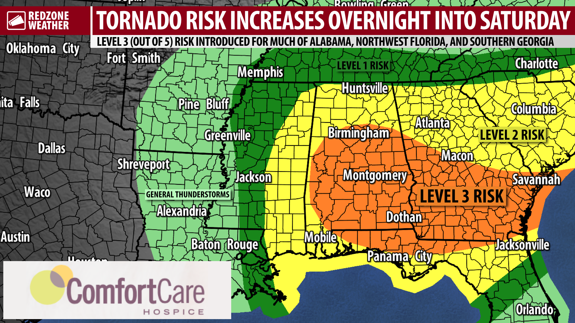
OVERNIGHT TORNADO RISK INCREASING; LEVEL 3 (OUT OF 5) RISK… The Storm Prediction Center has upgraded part of our local area in a Level 3 (out of 5) enhanced severe weather risk valid for tonight into Saturday morning. The overall risk of a few tornadoes has increased, particularly in the overnight hours (unfortunately), ahead of the arrival of a line of strong to severe thunderstorms. The local National Weather Service office has mentioned the possibility of an intense/strong tornado or two being possible (EF2), particularly in the higher risk zone. In addition to the tornado risk, damaging wind gusts, large hail, and flash flooding may become possible in the stronger storms. Please have a way to get urgent weather warnings tonight into Saturday.
LEVEL 3 (OUT OF 5) RISK ZONE… A Level 3 (out of 5) enhanced risk zone means that numerous severe storms will be possible. SPC now includes much of Clarke, Monroe, Conecuh, Butler, Covington, Escambia (AL), Santa Rosa, and Okaloosa counties in this higher risk zone. This includes places like Andalusia, Opp, Florala, Brewton, Atmore, Flomaton, Evergreen, Castleberry, Monroeville, Beatrice, Uriah, Grove Hill, Thomasville, Jackson, Jay, Laurel Hill, Baker, Crestview, Allentown, and surrounding areas.
LEVEL 2 (OUT OF 5) RISK ZONE… The remainder of our local are is involved in the Level 2 (out of 5) slight risk zone. This includes much of Washington, Mobile, Baldwin, and Escambia (FL) counties. This includes Mobile, Prichard, Saraland, Satsuma, Chatom, Millry, Fairhope, Daphne, Spanish Fort, Bay Minette, Gulf Shores, Orange Beach, Pensacola, Molino, Pace, Navarre, and Destin.
UPDATED: SEVERE WEATHER TIMING… Strong storms may begin as early as 10PM this evening, although I expect the core of the severe weather issues to happen later in the night. 2AM to 10AM is now the 8 hour window when strong to severe storms will be most likely. An afternoon round of thunderstorms may extend into the evening hours as well, although confidence in Round 2 of the storms in the afternoon and evening hours is much lower as it remains to be seen how much the morning round of storms will work over the atmosphere.
TORNADO WARNING POLICY… Any time there is an active tornado warning in effect for southwest Alabama or northwest Florida, we provide uninterrupted, live video coverage on Facebook Live and in the RedZone Weather app. Our detailed coverage commitment is outlined at redzoneweather.com/coverage. We are proud to cover all parts of Escambia (AL), Covington, Monroe, Conecuh, Baldwin, Mobile, Clarke, Washington, Butler, Escambia (FL), Santa Rosa, and Okaloosa counties. If you live in any locale in those counties, be sure to tune into our coverage whenever there is an active tornado warning!
APP ALERTS… If you haven’t already, be sure to download the free RedZone Weather app to keep up with all the latest information on the world of weather in south Alabama and northwest Florida. redzoneweather.com/app is the link for the free download. Once you have the app downloaded to your iOS or Android device, be sure to visit the Alerts tab (lower right corner) and tap the large, yellow Alert Settings button to customize the alerts you would like to receive straight from me.
I will have another update later this evening unless long form severe weather coverage is warranted before that. Have a nice Friday evening!