
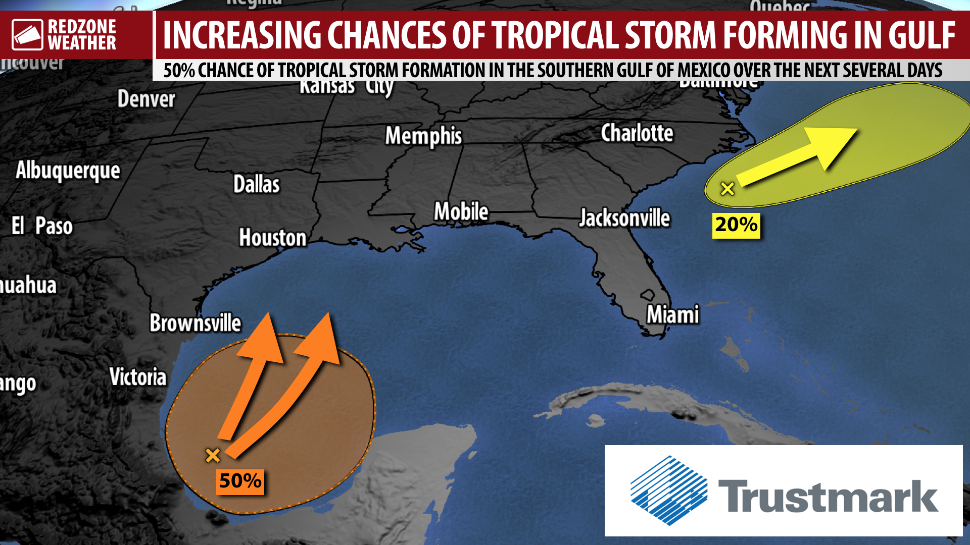
GROWING CHANCES OF TROPICAL STORM IN GULF LATER THIS WEEK… A tropical storm will probably form later this week in the southern Gulf of Mexico. The National Hurricane Center has upped development chances to a 50% chance. This developing storm will likely move north toward the U.S. Gulf Coast later this week or into the upcoming weekend. Local impacts in south Alabama and northwest Florida could become possible, most likely in the form of heavy rain and flash flooding, during the upcoming weekend. It is too early to know for sure if local impacts are likely, however. This is something we will be closely monitoring over the next few days as the synoptic setup continues to come into focus. Our local forecast remains consistent over the next several days with P.M. storms at times with plenty of heat and plenty of humidity. We’re also watching a separate system off the coast of the Carolinas that will not directly affect our local area. A few more Sunday evening forecast notes are below. Please join me tomorrow morning at 7:15AM for the very latest on the tropics in our next regularly-scheduled forecast video.
LOCAL IMPACTS ASSESSMENT: RAIN LIKELY AT TIMES THIS WEEKEND, AT MINIMUM… Rain chances will increase considerably on Saturday and Sunday as deep tropical moisture moves into our region. The most likely scenario, based on the ongoing global model guidance, shows this tropical storm potentially moving inland somewhere between Apalachicola, Florida on the east side to Brownsville, Texas on the west side. Obviously that is an extremely long stretch of coastline, indicating the ongoing uncertainty in the 5-7 day range. Depending on the exact track of the storm, other impacts, like tornadoes, gusty winds near the beaches, high surf and dangerous rip currents, and coastal flooding, may also become possible in our local area. It is too early to pinpoint exactly which impacts will be possible locally, but details should become more clear by midweek.
POP-UP STORMS LIKELY AT TIMES ON MONDAY… Another round of scattered showers and thunderstorms is expected to happen at times on Monday, particularly in the afternoon and evening hours. Highs on Monday will be in the mid-90s with heat index values rising to the 100-105° range. It is simply going to be quite hot and oppressively humid on Monday across all locales in south Alabama and northwest Florida.
SEPARATE STORM MAY DEVELOP OFF CAROLINA COAST… An area of disturbed weather southeast of the South Carolina and North Carolina coastlines will move northeast into the open waters of the northern Atlantic Ocean over the next few days. The National Hurricane Center says there is a 20% chance of a tropical storm forming as this system moves northeast. Regardless of if formal development happens, this system will NOT be a direct local issue for south Alabama or northwest Florida. From NHC: “A non-tropical area of low pressure has formed about 150 miles south of Wilmington, North Carolina and is producing disorganized showers and thunderstorms. This system is forecast to move northeastward for the next few days near the warm Gulf Stream, which could allow for some tropical development to occur while it moves away from the United States. The low should be over cold waters south of Nova Scotia by midweek, ending its development chances.”
APP ALERTS… redzoneweather.com/app is the link where you can download the free RedZone Weather app. We post brief updates throughout each day in the app, keeping you up-to-date about the latest happenings in weather across south Alabama and northwest Florida. Once you have the free app downloaded to your iOS or Android device, be sure to visit the Alerts tab (lower right corner) then tap the large, yellow Alert Settings button to customize the alerts you would like to receive straight from me.
I will have your next detailed forecast video and text discussion posted by 7:15AM tomorrow morning. Have a nice Sunday evening!