
HEAVY RAIN, FLASH FLOODING, AND TORNADOES ARE MAIN CONCERNS THIS WEEKEND… Rain is expected to be heavy at times this weekend as deep tropical moisture moves inland across our area from what will likely be Tropical Storm Claudette. Right now, the tropical disturbance currently known as INVEST 92L continues to meander around the Bay of Campeche in the southern Gulf. Tomorrow, however, the system is finally expected to begin moving north. Rain from the system may arrive in our local area in south Alabama and northwest Florida as early as Friday evening. Heavy rain will be possible at times locally this weekend. Flash flooding will be possible if rain and storms train over the same areas. Depending on the exact future track of the system, tornadoes may also be possible in our local area. Coastal hazards such as minor storm surge, coastal flooding, high waves, and rip currents are likely. The good news is we are not expecting high wind issues in our local area at this time. A few more Wednesday evening forecast notes are below.
90% CHANCE OF DEVELOPMENT – 92L… The National Hurricane Center continues to indicate there is a 90% chance of a tropical storm forming in the western Gulf of Mexico over the next few days. A center of circulation is likely to form at some point tomorrow or on Friday. From NHC: “Disorganized showers and thunderstorms continue over the Bay of Campeche and southern Mexico in association with a broad low pressure area. This system will move little today and tonight, and little if any development is expected during that time due to interaction with land. However, the system should begin to move northward on Thursday, and a tropical depression is likely to form by late Thursday or on Friday when the low moves across the western Gulf of Mexico. An Air Force Reserve Unit reconnaissance aircraft is scheduled to investigate the area on Thursday. Regardless of development, heavy rainfall will continue over portions of Central America and southern Mexico during the next few days. Heavy rains should also begin to affect portions of the northern Gulf Coast on Friday. ”
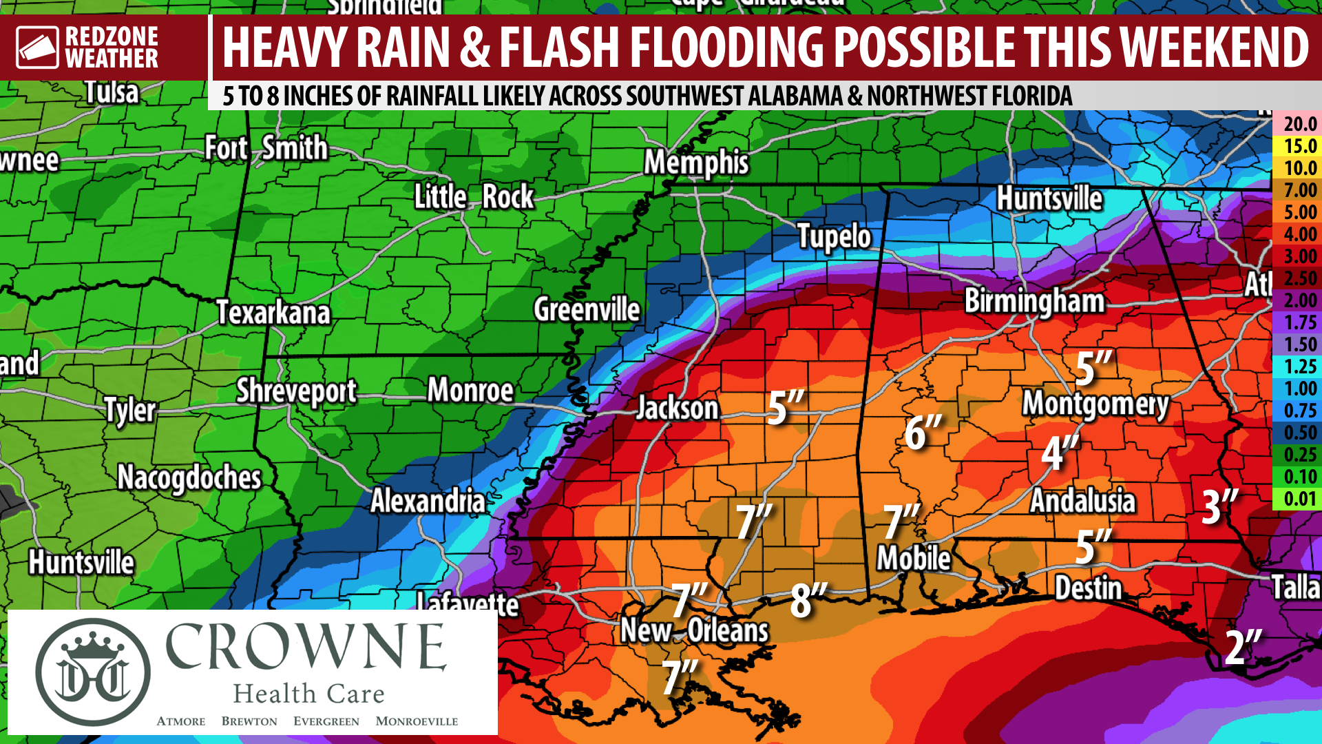
5 TO 8 INCHES OF RAINFALL LIKELY LOCALLY; FLASH FLOODING POSSIBLE… Clearly, the greatest threat from this developing tropical storm for our local area will be the potential for heavy rain and flash flooding. Right now, the Quantitative Precipitation Forecast (QPF) continues to show between 5 and 8 inches of rainfall in total through Monday with the greatest rain amounts happening in parts of Mobile, Baldwin, and Washington counties. Heavy rain will be possible throughout the day on Saturday and on Sunday, especially in areas closer to the coast. Flash flooding issues may become possible as early as Saturday if and when storms begin training over the same areas.
HIGH WIND RISK REMAINS QUITE LOW FOR OUR LOCAL AREA… I have had several questions throughout the day regarding the potential wind impacts expected locally. Right now, there is no threat of strong winds for any part of our area in south Alabama and northwest Florida because of this developing tropical storm. Gusty winds of 25-35 mph may happen near the Alabama and northwest Florida beach zones, but the overall chance of wind damage locally appears to be low.
TORNADOES POSSIBLE THIS WEEKEND… Since our local area will be on the eastern side of the advancing circulation of this developing tropical storm, we likely will have a tornado risk set up in at least part of our area. The center of the storm will be moving inland across Louisiana and Mississippi, thus it is logical to conclude that the greater tornado risk will happen in west Alabama and perhaps near our immediate beach zones in Alabama and northwest Florida. Timing for the specific tornado risk remains uncertain, for now. Please have a way to get warnings on Saturday and Sunday.
GREATER IMPACTS IN PARTS OF LOUISIANA AND MISSISSIPPI… A higher risk of all impacts discussed above will be possible just to our west in parts of Mississippi and Louisiana this weekend where the center of what will likely be Tropical Storm Claudette comes ashore. Please be aware of the potential for heavy rain, flash flooding, tornadoes, storm surge, and potentially higher wind gusts if you or someone you know is in parts of eastern Louisiana and southern Mississippi.
APP… Be sure to download our free RedZone Weather app if you haven’t done so already. redzoneweather.com/app is the link where you can download the app for your iOS or Android device. Once you have the app downloaded, be sure to visit the Alerts tab in the lower right corner of the app to select the specific notifications you would like to receive straight from me.
NEXT UPDATE… I will have your next detailed forecast video and long form text discussion posted by 7:15AM tomorrow morning. I’ll have all of the latest details concerning the tropics. Have a great Wednesday evening!