
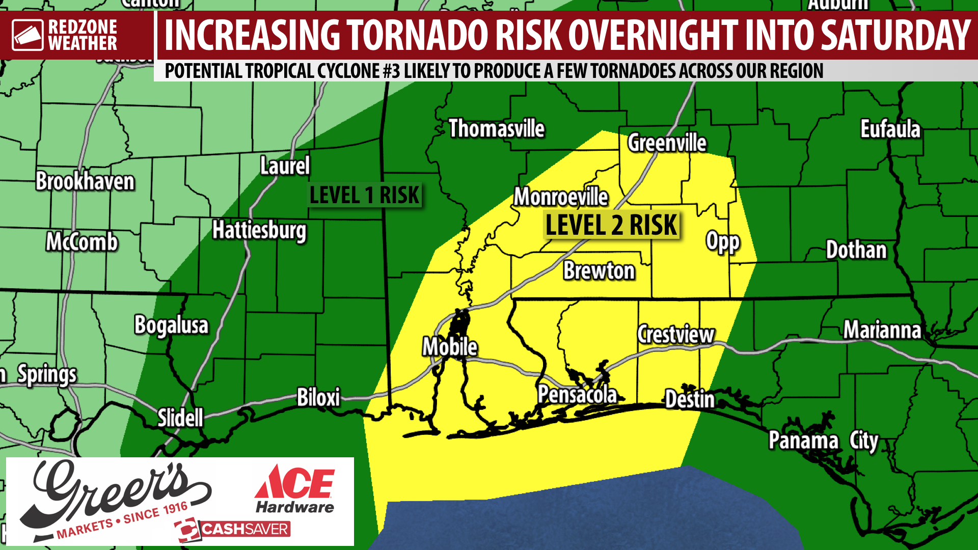
INCREASING RISK OF TORNADOES OVERNIGHT INTO SATURDAY; BE READY FOR WARNINGS… In addition to the ongoing threat of a significant heavy rain event that could lead to flash flooding across our region, the risk of a few tornadoes overnight into Saturday has increased. There is a potential for a few low-topped rotating showers and storms in the right front quadrant of this developing tropical storm. The Storm Prediction Center has upped the tornado probability valid for Saturday to their Level 2 (out of 5) risk. Tropical-induced tornadoes usually do not last very long, but can be quite impactful in localized areas. Thus, it is critical that you and your folks have multiple ways to get warnings overnight. You need something like a NOAA Weather Radio that can wake you up. Smartphone apps, like our free RedZone Weather app, are great, but often the “ding” notification we send may not be loud enough to wake some people up. As always, if and when a tornado warning is required for any part of our local area, we will come on Facebook Live and in the RedZone Weather app to bring you the latest information.
EVERYONE HAS A TORNADO RISK TONIGHT INTO SATURDAY… Usually we rely fairly heavily on the convective outlooks to ascertain exactly where the tornado risk may be highest. During this particular event, the “who is in what level/zone” does not matter. Why? Because the entire area has a tornado risk, fairly equal in magnitude. It is impossible to predict exactly where tornadoes will happen in advance, but you can bet there will probably be a few before the end of this event late tomorrow evening. Tornado warnings used to be issued for entire counties. About 14 years ago, the National Weather Service started issuing polygons for tornado warnings, keeping folks IN the polygon that are in danger and leaving folks out who are in no danger. Unfortunately, some older, county-based systems (including sirens) still exist. That is why it is important to tune in whenever you get a tornado warning to see if you are actually involved in the tornado warning polygon.
WHAT TO EXPECT – NEXT FEW HOURS… At 4:20PM, light to moderate rain is happening across parts of southern Mobile, southern Baldwin, and southern Escambia (FL) counties. There is a real chance rain may not stop anytime soon near Orange Beach, Gulf Shores, Fort Morgan, Dauphin Island, and Bayou La Batre. This large shield of rain will continue to spread inland over the next 4-6 hours. Scattered showers are happening inland near Calvert, McIntosh, Andalusia, Libertyville, Babbie, and Greenville as of 4:20PM.
4PM ADVISORY ON PTC #3… The National Hurricane Center decided to keep the status of the tropical system as a “Potential Tropical Cyclone” as of the 4PM advisory. While NHC continues to indicate there is a high probability of the storm officially taking a name (would be Claudette) in the hours ahead, I have some degree of doubt that will actually happen at this point. Regardless, we’re now at the point where it really does not matter. Why? IMPACTS will remain the same locally. Heavy rain, flash flooding, a few tornadoes, minor storm surge, minor coastal flooding, and gusty winds near the Alabama and northwest Florida beaches remain the concerns.
APP ALERTS… If you haven’t already downloaded the RedZone Weather app, now is a great time to do that. redzoneweather.com/app is the link to the free download. Once you have the RZW app installed on your iOS or Android device, be sure to visit the Alerts tab to turn on the specific notifications you’d like to receive. All notifications are handcrafted by me. No automation and we promise not to bug you!
LIVE VIDEO LATER THIS EVENING… I will have another detailed live video update a bit later. We are aiming to start the live video at some point between 7:30PM and 9:30PM. Be sure to join us for the very latest information during the live video. More updates will be posted throughout the evening and into the night in the RedZone Weather app. Have a nice Friday evening!