
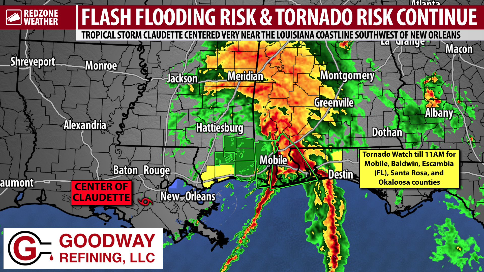
PTC #3 BECOMES TROPICAL STORM CLAUDETTE; POSSIBLE TORNADO INJURY… The National Weather Service says one man was possibly injured by a 2×4 board that was launched into a pickup truck by a tornado that happened earlier this morning in southern Mobile County. There was a tornado warning in effect at the time the incident happened. No word yet on the man’s condition. Our thoughts and prayers are with the tornado victim and his family. Potential Tropical Cyclone #3 officially became Tropical Storm Claudette in the 4AM advisory. The change really means nothing at this point as impacts are ongoing across our local area. Right now, an intense band of heavy rainfall is slowly moving across parts of Baldwin County. Flash flooding is happening in many areas across southeast Mississippi and across Mobile County, AL. There is a high chance we will have more flash flooding issues across our region as well in the hours ahead as heavy rain continues. A risk of tornadoes continues over the next several hours.
TORNADO WATCH FOR COASTAL COUNTIES… A Tornado Watch is in effect until 11AM for all parts of Baldwin, Mobile, Escambia (FL), Santa Rosa, and Okaloosa counties. A few tornadoes will be possible through late morning in these coastal counties. The tornado risk may expand farther inland in the afternoon and early evening hours. A new Tornado Watch may be needed later for areas farther inland.
FLASH FLOOD WARNING… Rain rates of 3-4″ per hour are happening as of 7:10AM across much of Baldwin County and in the northern halves of Escambia (FL) and Santa Rosa counties. We note all of Mobile and Baldwin counties and much of Escambia (FL) County is under a Flash Flood Warning. Also, the western fringes of Santa Rosa County and Escambia (AL) County are involved in the Flash Flood Warning. This includes Atmore, Nokomis, Downtown Mobile, Prichard, Saraland, Satsuma, Creola, Mt. Vernon, Citronelle, Gulf Crest, Chunchula, Wilmer, Theodore, Tillmans Corner, Irvington, Bayou La Batre, Coden, Fowl River, Dauphin Island, Foley, Magnolia Springs, Fairhope, Montrose, Daphne, Spanish Fort, Bay Minette, Perdido, Gulf Shores, Fort Morgan, Orange Beach, Elberta, Seminole, Tensaw, Stockton, Stapleton, McDavid, Walnut Hill, Molino, Bratt, Pensacola, Gonzalez, Ensley, Warrington, Perdido Key, Gulf Breeze, Pensacola Beach, Pace, and surrounding areas.
APP… Many updates will be posted throughout the day in the RedZone Weather app. redzoneweather.com/app is the link for the free download. Be sure to visit the Alerts tab (bottom right corner) and tap the large, yellow “Alert Settings” button to customize the alerts you’d like to receive from me. If you like a lot of info, be sure to toggle ON Low-Level Alerts.
If and when a tornado warning is issued for our local area, I will start our nonstop, live video coverage on Facebook Live and in the RedZone Weather app. Have a good Saturday morning!