
SEVERE STORMS & TORNADOES POSSIBLE WEDNESDAY P.M. INTO EARLY THURSDAY… Another round of strong to severe thunderstorms is slated to happen on Wednesday evening into early Thursday morning across parts of southwest Alabama and northwest Florida. Tornadoes, damaging straight line winds, hail, and flash flooding will all be possible. Unlike the severe weather event last week, I expect this round of storms to probably be a bit more linear in nature, thus the most likely scenario for severe storms this week will probably be a squall line pushing from west to east across the local area. This means that the overall risk of damaging straight line winds may be a bit higher compared to the last few severe weather events. As always, if tornado warnings are needed locally Wednesday night, we will “go live” on Facebook and across our RedZone Weather platforms to bring you the very latest information. We encourage everyone to have a way to get urgent weather warnings on Wednesday night. Since this will be an overnight event for most locales, you’ll need a device like a NOAA Weather Radio that can wake you up if a warning is needed for your specific location. A few more Monday evening details are below.
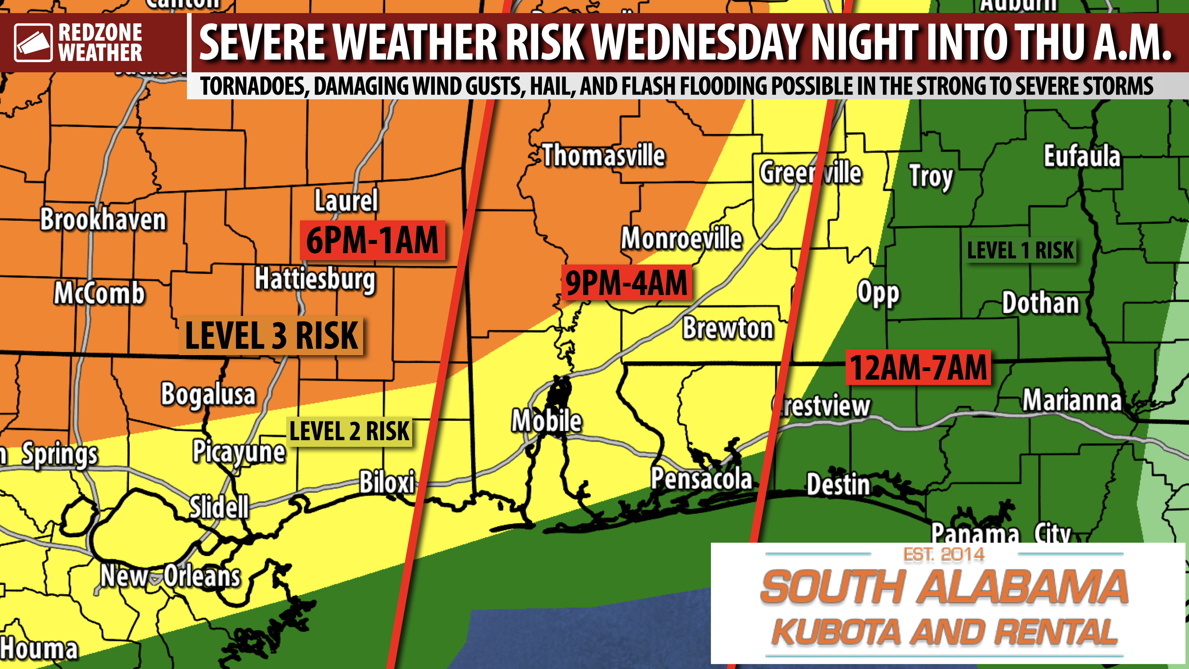
SEVERE WEATHER TIMING – WEDNESDAY INTO THURSDAY… Wednesday evening into early Thursday morning is when the primary severe weather risk will likely set up across south Alabama and northwest Florida. 6PM Wednesday to 6AM Thursday is the 12 hour window when severe weather threat will likely maximize across our area. 9PM to 3AM looks to be the 6 hour “core risk” window for local areas. Again, please have a way to get warnings Wednesday night.
STRONG TORNADOES POSSIBLE… The Storm Prediction Center notes that a few significant or strong (EF2+) tornadoes will be possible Wednesday into Wednesday night, particularly across Mississippi and west Alabama. The overall risk of damaging winds may be a bit higher across our local area (compared to areas to our northwest that may have a higher tornado risk). Damaging straight line winds can often cause damage that rivals tornado damage. If your area goes under a severe thunderstorm warning later this week, this will definitely be a time to take those warnings (in addition to tornado warnings!) seriously.
LEVEL 3 (OUT OF 5) RISK FOR WEST ALABAMA AND POINTS WEST… The highest tornado risk will likely set up across parts of Monroe, Clarke, Washington, Marengo, Wilcox, and Choctaw counties in southwest Alabama. This includes places like Thomasville, Monroeville, Jackson, Grove Hill, Coffeeville, Whatley, Gosport, Leroy, Chatom, Millry, Vinegar Bend, Wagerville, St. Stephens, Salitpa, Butler, Gilbertown, Toxey, Pennington, Linden, Sweet Water, Demopolis, Camden, and Pine Hill. We also note this Level 3 (out of 5) severe weather risk includes places to our north such as Tuscaloosa, Demopolis, Livingston, Aliceville, Hamilton, Selma, Marion, Eutaw, Centreville, Jasper, and Double Springs. A Level 3 (out of 5) enhanced severe weather risk means that severe storms are likely with some of the storms potentially being intense and/or long-lasting.
LEVEL 2 (OUT OF 5) RISK FOR MUCH OF OUR LOCAL AREA… Much of our local area continues to be involved in the Level 2 (out of 5) severe weather risk zone valid Wednesday into early Thursday. This is the zone where scattered severe thunderstorms, including tornadoes, may be possible. This Level 2 (out of 5) risk zone currently includes Mobile, Wilmer, Mt. Vernon, Theodore, Daphne, Fairhope, Spanish Fort, Magnolia Springs, Foley, Bay Minette, Robertsdale, Summerdale, Tensaw, Atmore, Brewton, East Brewton, Poarch, Flomaton, Huxford, Pineview, Walnut Hill, Gonzalez, Molino, McDavid, Century, Jay, Milton, Pace, Andalusia, Evergreen, Repton, Castleberry, Owassa, Range, Lenox, Brooklyn, Excel, Frisco City, Uriah, Beatrice, Greenville, Forest Home, Georgiana, McKenzie, and surrounding areas.
LEVEL 1 RISK FARTHER SOUTH AND EAST… Locales near the Alabama and northwest Florida beaches and communities a bit farther east in our local area remain involved in the low-end, Level 1 (out of 5) severe weather risk zone. This is the zone where a few severe storms may be possible, but the risk is less likely. This zone currently includes Fort Morgan, Gulf Shores, Orange Beach, Pensacola, Gulf Breeze, Pensacola Beach, Navarre, Destin, Mary Esther, Eglin AFB, Niceville, Crestview, Baker, Laurel Hill, Florala, Onycha, and Opp.
APP… If you haven’t already downloaded the RedZone Weather app, now is a great time to do that. redzoneweather.com/app is the link to the free download. Once you have the RZW app installed on your iOS or Android device, be sure to visit the Alerts tab to turn on the specific notifications you’d like to receive. All notifications are handcrafted by me. No automation and we promise not to bug you!
My next detailed forecast video and text discussion will be posted by 7:15AM tomorrow morning. Until then, more updates will be posted tonight and tomorrow morning in the RedZone Weather app. Have a nice Monday evening!