
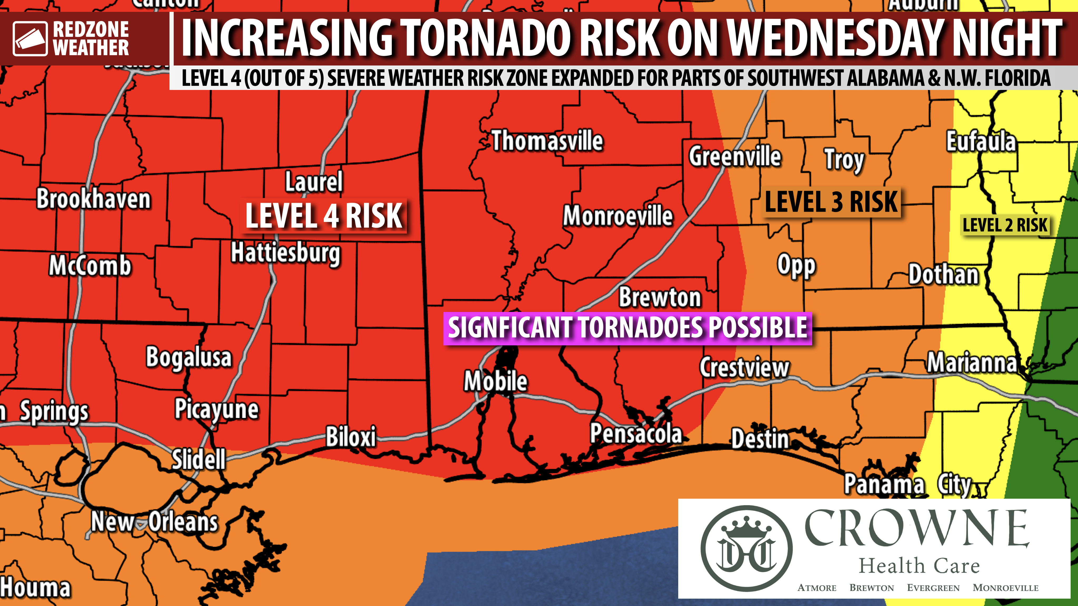
LEVEL 4 (OUT OF 5) RISK EXPANDED; MAJOR SEVERE WEATHER RISK AHEAD WEDNESDAY INTO THURSDAY… Much of southwest Alabama and northwest Florida are now involved in the Level 4 (out of 5) severe weather risk valid for Wednesday evening into Thursday morning, in the latest convective outlook update as of 12:45PM Tuesday. Regardless of which color/number risk level your specific hometown is involved with, this is slated to be a potentially significant severe weather event across much of the Deep South. Tornadoes (some strong, EF2+ tornadoes), damaging straight line winds (that could be particularly intense causing widespread power outages), hail, and flash flooding will be possible. The timing on this severe weather setup has not changed. 6PM Wednesday to 6AM Thursday is the 12 hour risk zone. It cannot be emphasized enough: Please have a way to hear warnings tomorrow night! You need a device capable of waking you up if your location goes under an urgent weather warning. Please “be the hero” and help me get this info out to people that may not be as weather aware as you. Tomorrow night will be one of these nights where we all need to keep an eye on the weather as multiple, significant tornadoes and a particularly intense damaging wind risk will exist. No need to worry or panic, but just have a way to hear warnings and get sheltered if a warning is needed for your specific location.
SEVERE WEATHER TIMING – WEDNESDAY INTO THURSDAY… Wednesday evening into early Thursday morning is when the primary severe weather risk will likely set up across south Alabama and northwest Florida. 6PM Wednesday to 6AM Thursday is the 12 hour window when severe weather threat will likely maximize across our area. 9PM to 3AM looks to be the 6 hour “core risk” window for local areas. Again, please have a way to get warnings Wednesday night.
TORNADO WARNING POLICY… Any time there is an active tornado warning in effect for southwest Alabama or northwest Florida, we provide uninterrupted, live video coverage on Facebook Live and in the RedZone Weather app. Our detailed coverage commitment is outlined at redzoneweather.com/coverage. We are proud to cover all parts of Escambia (AL), Covington, Monroe, Conecuh, Baldwin, Mobile, Clarke, Washington, Butler, Escambia (FL), Santa Rosa, and Okaloosa counties. If you live in any locale in those counties, be sure to tune into our coverage whenever there is an active tornado warning!
APP ALERTS… Many updates will be posted over the next few days in the RedZone Weather app. redzoneweather.com/app is the link for the free download. Be sure to visit the Alerts tab (bottom right corner) and tap the large, yellow “Alert Settings” button to customize the alerts you’d like to receive from me. If you like a lot of info, be sure to toggle ON Low-Level Alerts.
I will have more detailed updates posted later this evening. Be sure to check in tomorrow morning at 7:15AM for the morning video as we look ahead to this substantial severe weather risk setting up for tomorrow night. Have a great Tuesday afternoon!