
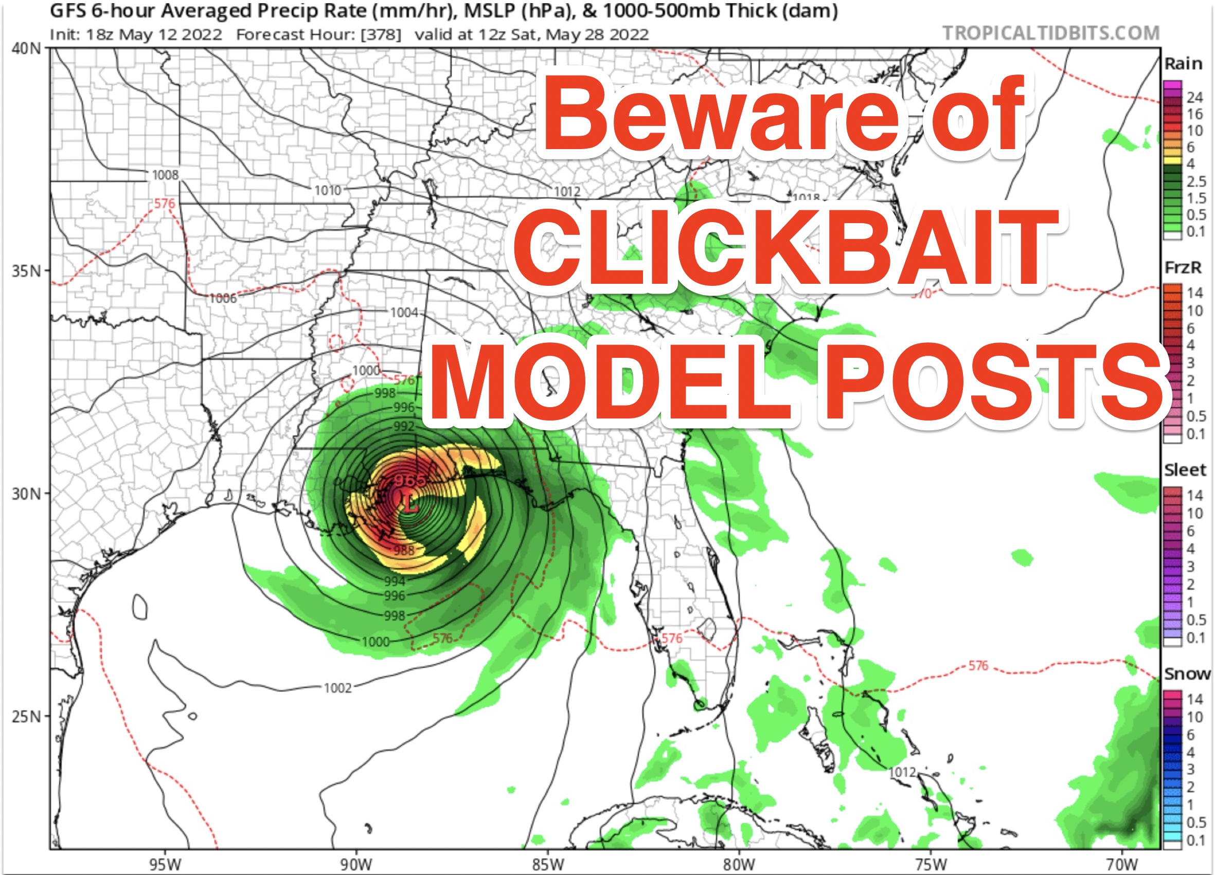
‘TIS THE SEASON FOR WILD SINGLE RUN MODEL IMAGES… Every year in the month of May, it seems like clockwork that single images of singular model runs are posted everywhere on social media depicting a hurricane making landfall somewhere along the Gulf Coast. I have seen a TON of these floating around social media over the last few days. Here’s the truth: There is a real chance we may have some tropical mischief in the Gulf in 2-3 weeks as we approach hurricane season. To suggest a landfall location at this point is borderline foolish, however. I would kindly ask everyone to remember three important things…
1) Any “weather page” that is not a trained meteorologist or credible source should be discarded. Plain and simple. “Gulf Coast Weather Updates,” “Gulf Hurricane Updates,” “Tropical Weather Source” could be operated by the Russians themselves for all we know. The rule of thumb as to how to identify a reputable weather source: Look for someone putting their name on the line. Local news stations, the local National Weather Service offices, local EMA, etc. Let me emphasize that I don’t have to be your weather source. That’s not what I am saying here. What I am saying is *please use credible sources.* In fact, I think it behooves everyone to have MULTIPLE ways to get good, reliable information. If you like our updates, great. Thank you for watching. If you don’t, that’s fine too. Just make sure you’re listening to a reputable source and not “Hurricane Central Updates” or some crazy, wild page on Facebook.
2) Single model runs are not the same as a handcrafted forecast. Think of a forecast as a finalized recipe with models being the many different ingredients in that recipe. Any trained meteorologist you follow uses multiple, well-known weather models to put together a forecast each day. One model is simply “one ingredient.” In this case, the Global Forecast System (GFS) has changed WILDLY each time it has been run over the last few days. There is a real chance this tropical feature it is detecting in a few weeks will go away entirely and never be an issue. Certainly nothing to stress over!
3) ANY “forecast” beyond 7 days out should be treated with a proverbial grain of salt. The images circulating wildly on social media are 14+ days out. FOURTEEN PLUS DAYS OUT. No one, and I truly mean NO ONE, can tell you with accuracy or precision what a weather forecast for a given point will be in 14 days. Ideas based on climatology of an area provide some clues, but even then, wild changes are possible. If a social media page is posting supposed “forecasts” beyond 7 days out, discard it.
BEWARE OF THE HYPE MACHINE… Long-time viewers and readers know that I do my best to “shoot it to you straight.” Hyperbole, hype, and fear mongering are totally unnecessary when communicating weather info. Moreover, posts that have NO context and post these wild, crazy model images are also pointless. Unfortunately, so many people these days love the “dopamine hit” that comes from getting numerous likes and shares on social media. The best thing to do when you come across a wildly inaccurate, hyped up weather post: Scroll on by and don’t interact with the post. Don’t feed the trolls, in other words.
A few showers and thunderstorms are happening this evening across parts of Mobile and Baldwin counties. No tornado risk with these storms. My next forecast video will be posted by 7:15AM on Friday morning. Have a great evening!