1:20AM 11/29/2020 – RZW Exec

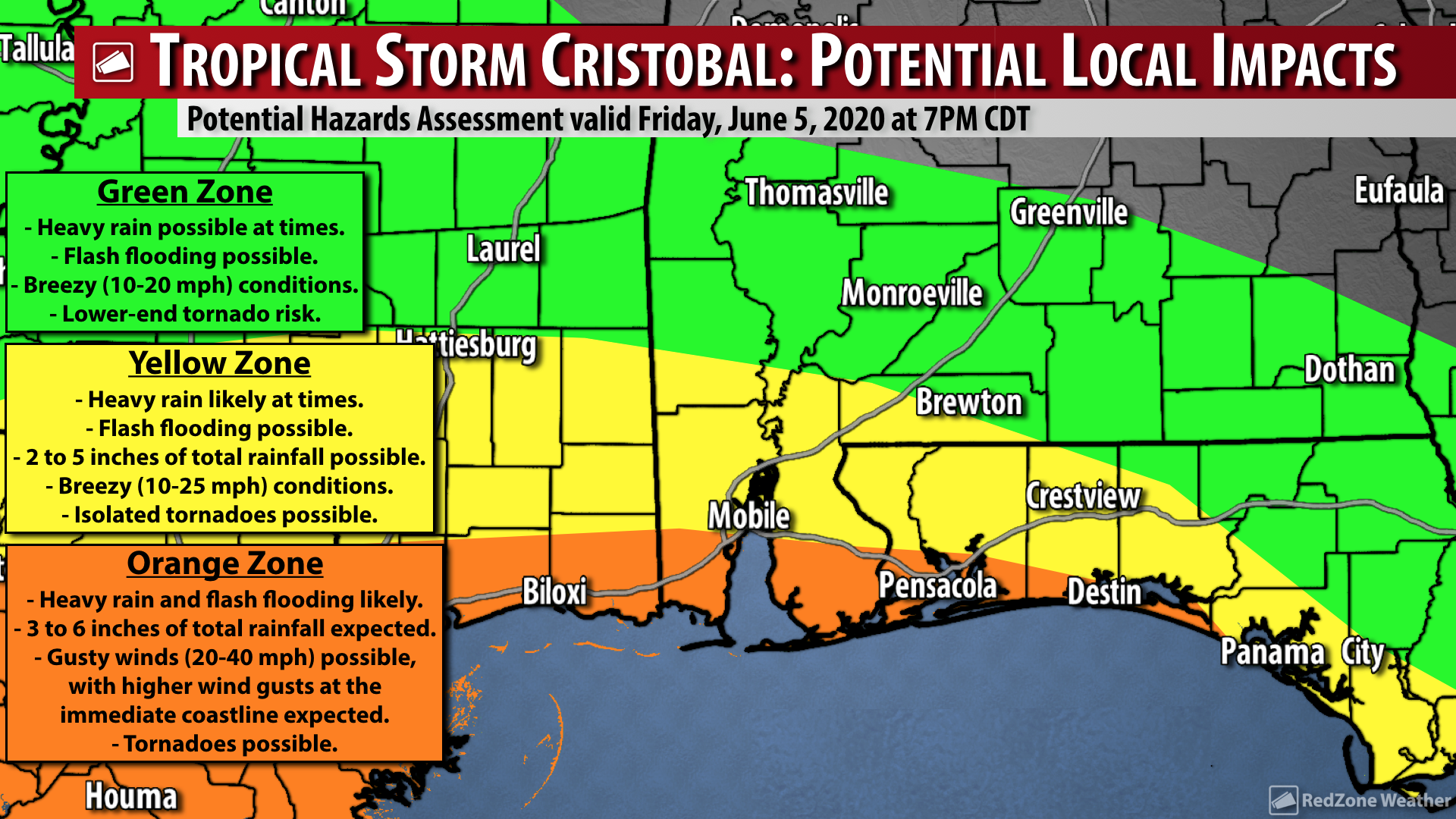
RZW EXEC: STRONG TO SEVERE STORMS POSSIBLE DURING P.M. HOURS TODAY… RZW Exec partners, good Sunday morning! There is a concern that a few isolated severe thunderstorms may develop this afternoon into this evening, specifically across our northwest Florida communities. The Storm Prediction Center has added a Level 2 (out of 5) severe weather risk zone for communities along and EAST of a line from Bayou La Batre to Fairhope to Andalusia. This includes places like Pensacola, Milton, Orange Beach, Destin, and Crestview. Communities like Mobile, Atmore, Bay Minette, Brewton, and Evergreen are involved in the lower-end, Level 1 risk zone. The main risk for a few tornadoes and gusty winds in the stronger storms will happen from 11AM to 6PM this evening. This risk will likely end completely by 8PM.

I generally do not send RZW Exec updates for temperature alerts, but please be aware we will have below freezing temperatures in place for many communities locally on Tuesday morning AND on Wednesday morning. Temperatures will be below 32 degrees for 2-4 hours early Tuesday morning with overnight lows projected to be in the upper-20s. Late Tuesday evening into Wednesday morning could feature a hard freeze with 6-10 hours of below freezing temperatures.

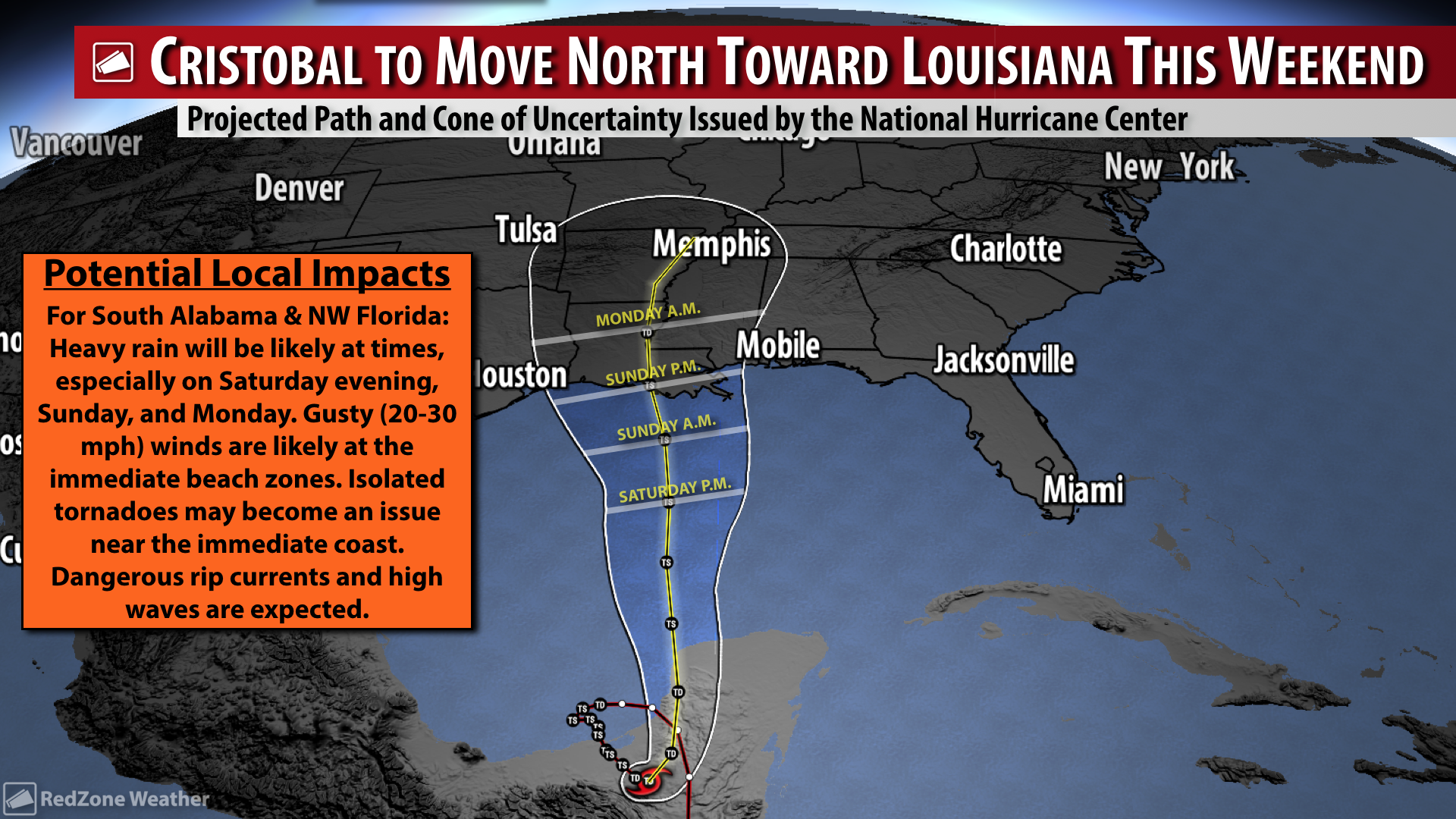
SEVERE STORMS, INCLUDING TORNADOES, POSSIBLE LATER TODAY… The severe weather risk for our local area has increased for today, with part of the region now involved in the Level 2 (out of 5) risk zone. Tornadoes and damaging wind gusts in the stronger storms will be possible. Heavy rain will be possible at times throughout the day. The risk for strong to severe storms will be maximized from midday into the afternoon and evening hours. 11AM to 6PM is the 7 hour window when severe weather seems most likely to happen. The tornado risk will likely be greatest in northwest Florida and closer to the coast, generally, with a much lower risk of severe storms farther inland due to a lack of atmospheric instability in those areas. As always, if and when we have tornado warnings, be sure to join us in live, uninterrupted video coverage. After the rain and storms today, skies will clear from west to east on Monday as cold, dry air moves in. All of your Sunday morning forecast details are below.

LEVEL 2 (OUT OF 5) RISK FOR PART OF THE AREA… The risk of severe weather today will be maximized closer to the immediate coast, but a tornado or two may be possible across inland areas as well. This is why the Storm Prediction Center has included several local communities in their Level 2 (out of 5) risk zone. This Level 2 risk zone is in place for the following communities: Pensacola, Orange Beach, Gulf Shores, Dauphin Island, Fairhope, Foley, Magnolia Springs, Elberta, Beulah, Gonzalez, Perdido Key, Molino, Milton, Pace, Berrydale, Munson, Jay, Gulf Breeze, Navarre, Andalusia, Opp, Florala, Crestview, Baker, Holt, Harold, Destin, Fort Walton Beach, Niceville, Mary Esther, and surrounding areas.

LEVEL 1 RISK ZONE… There is a lower-end, Level 1 (out of 5) severe weather risk in place today for communities generally to the north and west of the Level 2 risk. These are the communities that are less likely to experience severe weather, but a stronger storm or two may be possible. The Level 1 (out of 5) risk zone includes: Mobile, Prichard, Saraland, Satsuma, Bayou La Batre, Citronelle, Mt. Vernon, Bay Minette, Daphne, Spanish Fort, Bay Minette, Tensaw, Perdido, Walnut Hill, Bratt, Century, Flomaton, Atmore, Poarch, Huxford, Brewton, East Brewton, Red Level, Evergreen, Owassa, Repton, Range, Castleberry, Brooklyn, Georgiana, McKenzie, Uriah, and surrounding areas.

NO SEVERE WEATHER EXPECTED OVER INLAND WEST ALABAMA… The air mass in place over much of Washington, Clarke, Monroe, Choctaw, and Wilcox counties is expected to remain fairly stable, thus severe weather seems less likely in these counties. Thunder and lightning could accompany the heavy rain at times in these counties, but generally, the severe weather risk will remain farther to the south and east where the much more unstable air will be.

SEVERE WEATHER TIMING… Heavy rain will be possible at times throughout the day and into the evening. The overall tornado risk will be maximized from 11AM to 6PM, although keep in mind that severe storms may happen a few hours before or after that timeframe. We will likely be able to give an “all clear” from the severe weather risk by 9PM at the latest.

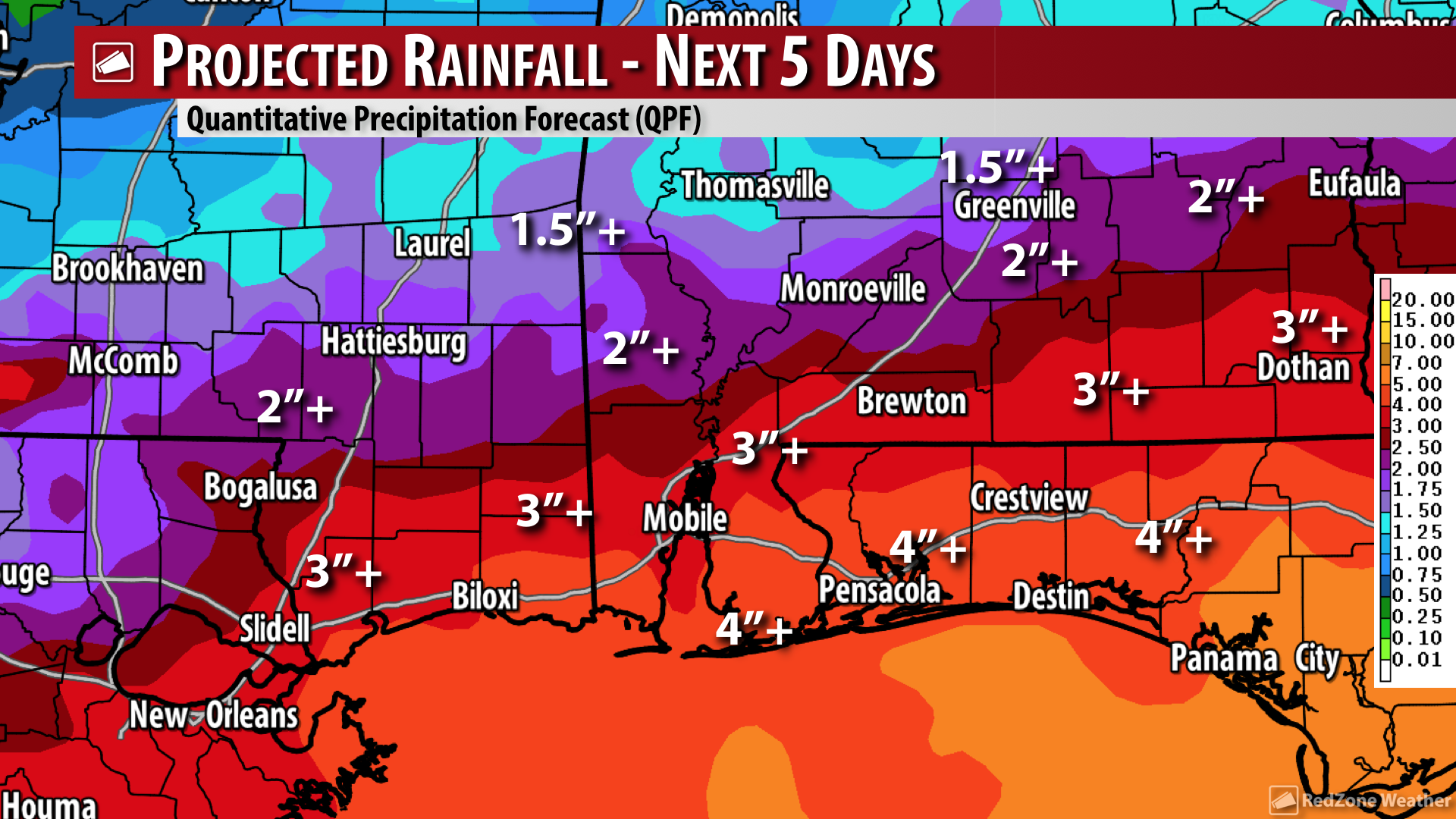
HEAVY RAIN EXPECTED AT TIMES TODAY… In addition to the risk of a few strong to severe storms capable of producing tornadoes and damaging wind gusts, heavy rain that could lead to flash flooding will be a concern. Total rainfall amounts across the region today are expected to be in the 1 to 3 inch range.

MUCH COOLER AIR ARRIVES TONIGHT… One of the reasons we have a chance of active weather today is because of an approaching cold front from the northwest. This frontal boundary will move across our region overnight, allowing cool, dry, stable air to move in for Monday.

COLD DAYS MONDAY THROUGH WEDNESDAY… Clouds will move out on Monday, giving way to clear skies for Tuesday and Wednesday. Since skies will be clear, there won’t be any cloud cover to help insulate the earth and act like a blanket of sorts, thus temperatures will be quite cold. High temperatures Monday through Wednesday will be in the 50s (low-50s on Monday and Tuesday).

BELOW FREEZING TEMPS TUESDAY & WEDNESDAY MORNINGS… The coldest mornings of the next 7 days will almost certainly be on Tuesday and Wednesday. Overnight lows will likely be in the mid- to upper-20s across inland areas of south Alabama with lower-30s likely closer to the immediate coast. Wednesday morning could meet the criteria of a hard freeze, with several hours of below freezing temperatures expected across inland areas. Clear skies are expected Tuesday and Wednesday.

SHOWERS LIKELY LATE IN THE WEEK… There is growing confidence we will have yet another round of rain by Thursday and Friday. No snow or wintry precipitation is in the forecast as temperatures will have warmed a bit compared to earlier in the week, meaning just a cold rain is expected. Temperatures will be in the upper-50s in the afternoon hours by Thursday and Friday with morning lows in the 40s.

TORNADO WARNING POLICY… Any time there is an active tornado warning in effect for southwest Alabama or northwest Florida, we provide uninterrupted, live video coverage on Facebook Live and in the RedZone Weather app. Our detailed coverage commitment is outlined at redzoneweather.com/coverage. We are proud to cover all parts of Escambia (AL), Covington, Monroe, Conecuh, Baldwin, Mobile, Clarke, Washington, Butler, Escambia (FL), Santa Rosa, and Okaloosa counties. If you live in any locale in those counties, be sure to tune into our coverage whenever there is an active tornado warning!

APP ALERTS… If you haven’t already, be sure to download the free RedZone Weather app to keep up with all the latest information on the world of weather in south Alabama and northwest Florida. redzoneweather.com/app is the link for the free download. Once you have the app downloaded to your iOS or Android device, be sure to visit the Alerts tab (lower right corner) and tap the large, yellow Alert Settings button to customize the alerts you would like to receive straight from me.

Have a great Sunday!

Tap below to support this RZW sponsor!

4:00PM 11/24/2020 – RZW Exec

RZW EXEC: FEW STRONG STORMS POSSIBLE WEDNESDAY… RZW Exec partners, good Tuesday evening! We have had a quiet couple of weeks in our local weather pattern, but that changes tomorrow. There is a low-end, Level 1 (out of 5) severe weather risk in place for much of central and north Alabama. Parts of Clarke, Washington, Monroe, and Butler counties are also involved in this low-end risk zone locally. Showers and thunderstorms should remain fairly scattered in nature on Wednesday and there is a chance some spots may get no rain. There is, however, a chance that some of the storms could be on the strong side in areas farther inland tomorrow afternoon and evening. The main concern will be gusty winds in the stronger storms. The tornado risk is very low, but it is not entirely zero for inland counties.

Please let me know if you have any questions or concerns. Our public post that will debut this evening detailing the low-end risk is below.

FEW STRONG STORMS POSSIBLE WEDNESDAY; TORNADO RISK LOW BUT NOT ZERO… Rain is set to finally return to our forecast on Wednesday, but along with that chance comes a risk of a few stronger thunderstorms. The main concern in any thunderstorms that can become strong or even marginally severe will be gusty winds capable of knocking down a few trees. The tornado risk is very low on Wednesday, but for inland areas, the tornado risk is not zero. The main risk of stronger storms will happen on Wednesday afternoon into the early evening hours. Rain totals with this event will generally be quite low, with most locales picking up less than one half inch of rain in total. The bigger rain event is slated to happen this weekend as another cold front approaches our area.

LEVEL 1 (OUT OF 5) RISK ZONE FOR INLAND AREAS… The Storm Prediction Center has included several of our inland communities in their low-end, Level 1 (out of 5) severe weather risk zone valid for Wednesday. Right now, parts of Clarke, Monroe, Butler, Washington, Choctaw, Wilcox counties, and areas to the north are included in this low-end risk zone. That includes Thomasville, Grove Hill, Jackson, Coffeeville, Chatom, Millry, Wagerville, Silas, Toxey, Gilbertown, Butler, Camden, Sweet Water, Pine Hill, Forest Home, and points north and west. The remainder of our local area is involved in the “general thunderstorms” zone where widespread severe weather is not expected on Wednesday.

SLIGHTLY INCREASED RISK FOR PARTS OF CENTRAL & NORTH ALABAMA… The greater dynamics and perhaps better combination of shear and instability is set to happen well to our north across parts of north and central Alabama along with parts of Tennessee. A squall line may develop across parts of northern Mississippi and western Tennessee and push eastward into the northern half of Alabama in the afternoon or evening hours. These are the areas that have the slightly higher risk of seeing damaging straight line winds and a tornado or two.

WHAT TO EXPECT – WEDNESDAY… Around sunrise on Wednesday, there could be a few small showers developing close to the Alabama and northwest Florida beaches. These areas of rain will gradually spread inland tomorrow morning. Scattered showers and storms will increase in coverage throughout the day. The low-end risk of a few stronger storms will happen in the afternoon and early evening hours.

THANKSGIVING DAY FORECAST… Thursday will be mostly dry across the region with mostly cloudy skies in place. Rain chances on Thanksgiving Day will be around 20%, meaning most of our area should remain dry. There also is a small chance of a few thunderstorms on Thanksgiving Day, but again, most spots will remain dry throughout the day. Severe weather is not expected on Thursday or on Friday. Temperatures will be quite mild for Thanksgiving with most spots peaking in the upper-70s.

SET UP APP ALERTS… We send quite a bit of Low-Level Alerts in our RedZone Weather app. The app is totally free for you! redzoneweather.com/app is the link where you see the download links to your respective app store for iOS and for Android devices. Once you have the app downloaded to your smartphone or tablet device, be sure to visit the Alerts tab to customize the alerts you would like to receive straight from me.

My next forecast video update will be posted by 7:15AM tomorrow (Wednesday) morning. See you then!

Tap below to support this RZW sponsor!

10:45AM 10/23/2020 – RZW Exec

RZW EXEC: GROWING CHANCE OF TROPICAL DEVELOPMENT THIS WEEKEND… RZW Exec partners, good Friday morning! There has been a considerable forecast shift in the future track for what is currently branded as INVEST 95L, an area of low pressure developing in the western Caribbean Sea south of Cuba. This system now has a 60% chance of becoming a tropical storm in the days ahead. As recently as last night, model guidance pointed to a storm that would likely move across Cuba and The Bahamas and race into the open waters of the northern Atlantic Ocean. Overnight, we saw a significant shift in guidance. The National Hurricane Center now suggests a track of this developing system into the Gulf of Mexico seems more likely. We will ramp up our public messaging about this shortly. I will have another RZW Exec update for you tomorrow (Saturday) or sooner, if needed.

TROPICAL STORM MAY FORM THIS WEEKEND IN CARIBBEAN OR SOUTHERN GULF… Talk about a significant forecast change! The National Hurricane Center now suggests there is a 60% chance of a tropical storm forming in the northwest Caribbean Sea or southern Gulf of Mexico in the days ahead with a chance of this system moving north toward the Gulf Coast. It is too early to know IF or when local impacts will happen in Alabama or northwest Florida, although early indications point to higher rain chances for the local area by the end of the upcoming week (approximately one week from now). Sea surface temperatures are significantly cooler in the Gulf of Mexico compared to the peak of hurricane season a few weeks ago, but this system goes to show: We’re not completely done with hurricane season just yet. I know SO many folks (including yours truly!) are very much ready for hurricane season to be over, but we still have a few weeks left. Hang with us in the days ahead and we’ll monitor trends and forecasts and bring you the latest in our RedZone Weather app. More details are below.

60% CHANCE OF TROPICAL STORM FORMATION… The 60% chance of tropical storm formation now in place for INVEST 95L represents a significant forecast change over the last 12-18 hours. Last night, the National Hurricane Center highlighted the area of concern in the Caribbean Sea (INVEST 95L) with a low-end (20-30%) chance of development with the storm likely moving northeast into the Atlantic. A northeasterly motion was also featured this morning at 2AM, which is what we highlighted in our morning video. NOW, a motion toward the Gulf of Mexico is expected due to a fairly abrupt shift in model guidance to the west. All of these changes highlight the continued uncertainty with the exact future of this developing tropical system.

LOCAL IMPACTS TO BE DETERMINED… It is too early to know IF or WHEN local impacts in south Alabama and northwest Florida will happen due to this developing tropical system. Models this morning, frankly, are “all over the board” with different tracks and intensities for this system going into next week. Impacts, if they happen locally, seem most likely to happen some time from Wednesday through Friday of the upcoming week. Please understand that is a tentative idea, based on the data we have at this moment, and is highly subject to change in the days ahead.

HURRICANE SEASON FATIGUE IS REAL… This is the LAST possible thing that anyone along the Gulf Coast (or really any coastal resident in the Atlantic Basin!) wants to hear after our hyperactive hurricane season so far. I understand that and to be frank, I am more than ready for hurricane season to end. However, just because we are all fatigued of hurricane season does not mean this risk will just “go away.” Thus, I would plead with you to please check in for updates in the days ahead. Hopefully this system will dissipate or just be a rainmaker. We will keep you posted every step of the way.

STORMS LIKELY TO POP UP THIS AFTERNOON… The radar is quiet at the time I am writing this update around 10:30AM. I expect scattered showers and thunderstorms to pop up this afternoon into this evening across south Alabama and northwest Florida. Severe weather is not expected, but there could be cloud-to-ground lightning in the stronger storms and isolated downpours of heavy rain. These areas of rain and storms are not associated with the tropical system, but are instead affiliated with the passing area of low pressure moving across our region tonight. I’ll have radar updates posted as needed in the RedZone Weather app.

APP… Be sure to download our free RedZone Weather app if you haven’t done so already. redzoneweather.com/app is the link where you can download the app for your iOS or Android device. Once you have the app downloaded, be sure to visit the Alerts tab in the lower right corner of the app to select the specific notifications you would like to receive straight from me.

NEXT UPDATE… I will have the next update on this developing system later this evening or sooner, if warranted. I will have plenty more updates coming in the RedZone Weather app in the hours ahead.

Tap below to support this RZW sponsor!

8:10PM 10/4/2020 – RZW Exec

RZW EXEC: TROPICAL STORM DELTA EXPECTED TO FORM ON MONDAY… RZW Exec partners, good Sunday evening! The latest data concerning what the National Hurricane Center has branded as “Potential Tropical Cyclone 26” has me concerned this evening. Forecast models have continually alluded to a potential direct hit or side swipe for our local area by what will likely be Hurricane Delta later this week. Let me be abundantly clear in stating I am not suggesting that a direct hurricane hit will happen locally, although I am concerned that the data has been so consistent today. We’re looking at a situation where rain begins Thursday evening with potential significant wind impacts on Friday into Friday night. In addition to heavy rain, flash flooding, and wind impacts (depending on where the exact center of Delta moves), isolated tornadoes, dangerous storm surge, coastal flooding, and river & creek flooding may become possible. The official NHC forecast (pictured above) calls for Delta to ramp up to a category 2 hurricane late in the forecast period on Friday. While there will be some limiting factors for the storm starting Thursday into Friday (like increasing shear and slightly cooler water temps), that may not matter too much if the storm is quite strong and moving quickly into our area or just to the east or west of our local area. As always, please let me know if you have decision support needs or questions. Our public messaging for tonight is below.

PTC26/DELTA-TO-BE MAY BE A HURRICANE ON APPROACH TO NORTHERN GULF COAST… Potential Tropical Cyclone 26, aka what will likely be Tropical Storm Delta soon, will likely be a hurricane in the Gulf of Mexico by midweek. There is a growing chance that local impacts in our local area, south Alabama and northwest Florida, will be possible later this week, perhaps on Friday into Saturday. We also note on this Sunday evening that there have been some forecast changes with Tropical Storm Gamma, currently located in the southern Gulf. Gamma may get in on the action too, potentially moving north later this week or this weekend. It is important that all of us across the region keep close tabs on the tropics, especially PTC26/Delta-to-be.

A PERSONAL NOTE ABOUT HURRICANE SALLY… Just keeping it real, I totally understand and realize that this is the LAST thing that many of you want to hear after the devastation caused by Hurricane Sally only 18 days ago. That is less than 3 weeks ago, and here we are looking at a situation where another hurricane may make a run at the northern Gulf Coast. I am tired of it, you are tired of it, we’re all tired of it. We’re tired of COVID, we’re tired of endless politics, and we’re tired of hurricane season. I get it, I promise. However, it is absolutely critical that we monitor these two tropical systems in the days ahead as unfortunately, there could be more significant impacts upcoming. The Atlantic Hurricane Season WILL end soon, but we’ve got to get through this week and this upcoming weekend before we see quieter conditions (hopefully).

POTENTIAL LOCAL IMPACTS FROM PTC26/DELTA-TO-BE… The potential impacts from PTC26/Delta-to-be would likely happen in south Alabama and northwest Florida would likely happen Friday into Saturday IF the storm indeed approaches our area or passes just to our west (thus putting our area on the volatile eastern side). Coastal impacts may begin as early as Thursday evening. Specific local impacts will largely depend on the exact future track of this storm, but there is little doubt that heavy rain will be a concern. Flash flooding and potentially river and creek flooding could become a concern. Isolated tornadoes will be possible. The wind impacts will be largely dependent on exactly where the center of the storm goes, but keep in mind that our local area IS in the “cone of uncertainty” even 5 days out, thus it is possible that we could have a direct hit from the center of what could be Hurricane Delta at that point. That is NOT a certainty at this point by any stretch, but it is a possibility and one that we all should be preparing for in the days ahead. Please check back with me on Monday and Tuesday for new information as forecast changes are expected.

HURRICANE WATCH MAY BE NEEDED FOR NORTHERN GULF COAST BY TUESDAY… A Hurricane Watch is in effect for parts of Cuba (Pinar del Rio and Artemisa) and the Isle of Youth. A Tropical Storm Warning is in effect for the Cayman Islands including Little Cayman and Cayman Brac. A Tropical Storm Watch has been issued for the Cuban province of La Habana. A Hurricane Watch or Tropical Storm Watch will likely be needed for parts of the northern Gulf Coast here in the U.S. tomorrow (Monday) or on Tuesday.

FORECAST CHANGES FOR TROPICAL STORM GAMMA… Tropical Storm Gamma is located in the southern Gulf of Mexico on this Sunday evening with the center of the storm being about 170 miles north of Cozumel, Mexico. Gamma is drifting erratically around the southern Gulf, but at this moment, the storm is moving east-northeast at about 3 mph. NHC continues to indicate that a large subtropical ridge of high pressure will build in and push Gamma to the west starting tomorrow (Monday). We note that the long-term prognosis for Tropical Storm Gamma has changed a bit today, with the general model consensus now suggesting a sudden jolt to the north in about 5-6 days. That means that while PTC16/Delta (which will likely be a strong tropical storm or hurricane) is in the central and northern Gulf, Gamma may be in the Bay of Campeche ALSO getting set to move north. It should be emphasized that long-term forecast idea is highly uncertain and we need to get more data in over the next 24-48 hours to have a better idea of where Gamma will ultimately end up.

SET UP APP ALERTS… We send quite a bit of Low-Level Alerts in our RedZone Weather app. The app is totally free for you! redzoneweather.com/app is the link where you see the download links to your respective app store for iOS and for Android devices. Once you have the app downloaded to your smartphone or tablet device, be sure to visit the Alerts tab to customize the alerts you would like to receive straight from me.

NEXT UPDATE… I will have your next highly detailed video and longer form text discussion posted by 7:15AM on Monday. Have a good Sunday evening!

Tap below to support this RZW sponsor!

7:45PM 10/3/2020 – RZW Exec

RZW EXEC: TROPICAL STORM LIKELY TO BE SOUTH OF US BY MIDWEEK… RZW Exec partners, I hope each of you are having a nice Saturday evening. There is now a high (70%) chance that a tropical storm will develop in the northwest Caribbean Sea (totally separate from ongoing Tropical Storm Gamma) in the days ahead. This new tropical storm will likely be in the south-central Gulf of Mexico by Wednesday of the upcoming week. It is far too early to know if impacts will happen in south Alabama and northwest Florida because of this developing storm, but that IS a possibility based on some of the major global models. Our detailed post (below) outlines what we know and what we do not know on this Saturday evening. I will have another RZW Exec update on this developing situation on Sunday. Please let me know if you have any questions.

TROPICAL STORM LIKELY TO BE IN CENTRAL GULF BY MIDWEEK… There will likely be a tropical storm just to our south in the south-central Gulf of Mexico by the middle part of the upcoming week. The National Hurricane Center has upped the odds of development for this system to 70%. This developing storm is totally separate from Tropical Storm Gamma, which is currently centered inland over the northeastern corner of the Yucatan Peninsula. Gamma will not be a concern for us locally anytime soon (if ever), but this other developing storm could be a different story. While it remains too early to know the exact future track of this developing storm, we note that some of the major global models show a weak tropical storm moving north toward Louisiana, Mississippi, Alabama, or northwest Florida. All of our Saturday evening forecast notes are below.

70% CHANCE OF TROPICAL STORM DEVELOPING IN CARIBBEAN… There is now a 70% chance that the tropical disturbance currently situated in the central Caribbean Sea will become a tropical storm over the next 5 days. The system will likely develop near or just northwest of Jamaica in the northwest Caribbean Sea. Where the exact low-level center of circulation develops could tell us quite a bit about the future track of the storm. If the low-level center develops on the eastern flank of the development probability zone and hugs the Cuban coastline for a few days as it treks northwest, the system may emerge as a weaker storm in the Gulf of Mexico early next week. The Florida Keys may have impacts from this developing storm under this scenario. On the contrary, if the low-level center forms a bit farther west, land interaction with Cuba may not be as much of a hinderance and the storm could be stronger when it moves into the Gulf.

LOCAL COASTAL IMPACTS MAY BECOME POSSIBLE BY END OF NEXT WEEK… Let me vehemently emphasize on this Saturday evening that we DO NOT KNOW exactly where this developing storm will go. Could it be a potential issue for our local area in south Alabama and northwest Florida? YES, it absolutely could, especially in terms of coastal impacts. On the flip side, there IS a significant chance we won’t ever deal with any significant impacts from this developing storm at all. It simply is too early to know specifics, but being that impacts will be possible, this means we all need to keep an eye on this storm in the days ahead. Be sure to check back with me for updates on Sunday and into early next week!

TROPICAL STORM GAMMA OVER THE YUCATAN PENINSULA… Tropical Storm Gamma is located over the northeastern corner of Mexico near Cancun and Cozumel this evening. Maximum sustained winds are near 60 mph with minimum central pressure at 990 millibars. Gamma is moving northwest at 8 mph. The center of the storm is expected to move into the far southern Gulf of Mexico tomorrow (Sunday) morning before stalling out for a day or so. After that, Gamma will likely be pushed southwest into the Bay of Campeche where it will likely not move very much at all. This storm has already been a prolific rainmaker for northeastern Mexico on the Yucatan Peninsula. More rain and flash flooding issues are expected there in the days ahead. Gamma will not be an issue for our local area in the next 5 days, however.

GAMMA INTERACTION WITH OTHER TROPICAL STORM POSSIBLE… Thinking back to several weeks ago, there was a huge interest in a potential Fujiwhara interaction between Hurricane Laura and Hurricane Marco. That never really happened as Marco faded away and Laura ended up being a massive, powerful, category 4 hurricane that slammed into southwest Louisiana. Some model guidance does suggest that Gamma and this developing storm (likely Delta-to-be) could potentially interact with one another next week. This is more of a curiosity than anything else at this point, but the ramifications are that Gamma may act to swing Delta-to-be a bit farther west. These storms likely would not merge since they would be similar in strength during their Fujiwhara interaction, and no, these storms would not come together to form a “superstorm.” I had that question more than you would like to believe during the Laura/Marco scenario a few weeks ago. The “superstorm merger” idea is not realistic.

HIGH CONFIDENCE: DEVELOPING STORM, IMPACTS POSSIBLE FOR CUBA… Just to recap what there is HIGH confidence in this evening: A tropical storm will likely develop in the western Caribbean Sea near or south of the southern coastline of Cuba. This storm will likely emerge into the far southern Gulf of Mexico some time early next week.

VERY LITTLE CONFIDENCE: GULF OF MEXICO TRACK… What we simply cannot know this far out is where the developing storm will ultimately end up. One good thing working in our favor is that Hurricane Sally significantly cooled the sea surface temperature of the northern Gulf of Mexico. The prolific rainfall combined with the storm’s slow movement mean water temperatures are not nearly as supportive for a strong hurricane at this point. It remains to be seen whether this storm can even reach the northern Gulf. Something to watch in the days ahead.

MOSTLY SUNNY, NICE SUNDAY LOCALLY… Skies will remain mostly sunny on Sunday across south Alabama and northwest Florida. High temperatures will peak near 80 degrees in most spots. There could be a few passing clouds, especially across northwest Florida and near the Alabama beaches. These clouds are actually streaming northeast along an old frontal boundary that extends southwest to Tropical Storm Gamma. Again, Gamma will not be a concern for the local area anytime soon (if ever). The bigger concern is definitely the developing tropical disturbance approaching Jamaica in the Caribbean Sea.

NEXT NAMED STORM: DELTA… We have been naming tropical storms from the Greek Alphabet over the last few weeks since we ran out of the standard English alphabetical list for the 2020 season. Subtropical Storm Alpha was the first Greek-named storm. It moved into Portugal and Spain a few weeks ago. Tropical Storm Beta developed in the Gulf of Mexico and moved into Texas before its remnants moved near and just west of our local area. Gamma is over the Yucatan Peninsula now. The next name in the Greek Alphabet is Delta. Beyond Delta, the following names would be Epsilon and Zeta.

APP ALERTS… Many updates will be posted throughout the day in the RedZone Weather app. redzoneweather.com/app is the link for the free download. Be sure to visit the Alerts tab (bottom right corner) and tap the large, yellow “Alert Settings” button to customize the alerts you’d like to receive from me. If you like a lot of info, be sure to toggle ON Low-Level Alerts.

NEXT UPDATE… I will have your next highly detailed video and longer form text discussion posted tomorrow (Sunday) afternoon. Enjoy the ongoing college football games tonight. Have a great Saturday evening!

Tap below to support this RZW sponsor!

4:05PM 9/23/2020 – RZW Exec

RZW EXEC: LOW-END TORNADO RISK OVERNIGHT INTO THURSDAY… RZW Exec partners, good Wednesday evening! We have a developing, yet low-end, risk of a few tornadoes setting up for the overnight hours into Thursday as the remnant circulation of former Tropical Storm Beta continues to approach Alabama from the west. The concern is that a few strong to severe thunderstorms could briefly ramp up to the point of producing a tornado or two on Thursday, mainly in the morning and early afternoon hours. The entirety of south Alabama and northwest Florida is involved in this low-end tornado risk. We will go into long form tornado warning coverage if any warnings are required for our local area. Please let me know if you have any questions or decision support needs. Our public messaging concerning this event are below. Have a great Wednesday!

FEW, BRIEF TORNADOES POSSIBLE OVERNIGHT INTO THURSDAY… The Storm Prediction Center has included ALL of south Alabama and northwest Florida in their low-end, Level 1 (out of 5) risk for a few tropical tornadoes overnight into Thursday as the remnants of Tropical Storm Beta pass to our northwest. While tropical-related tornadoes generally are weak and brief, they sometimes can knock down trees, damage roofs, and cause other damage. The risk of tornadoes will increase overnight as a warm front gradually moves northward across our region. This risk will extend into Thursday.

LEVEL 1 (OUT OF 5) SEVERE WEATHER RISK FOR ENTIRE LOCAL AREA… The Storm Prediction Center now includes ALL of the southern half of Alabama and all of northwest Florida in their Level 1 (out of 5) marginal severe weather risk, primarily driven by a chance of a few, brief tornadoes. This risk includes all parts of the following counties. If you live in ANY part of any of these counties, you’re included in this risk zone starting early Thursday morning: Washington (AL), Clarke, Monroe, Wilcox, Choctaw, Marengo, Conecuh, Butler, Covington, Crenshaw, Escambia (AL), Baldwin, Mobile, Lowndes, Montgomery, Pike, Barbour, Coffee, Dale, Henry, Houston, Geneva, Escambia (FL), Santa Rosa, Okaloosa, Walton, Holmes, Washington (FL), Jackson, Calhoun, Bay, and Gulf counties.

TIMING – TORNADO RISK OVERNIGHT INTO THURSDAY… Tornadoes will become possible overnight with the risk extending into the daytime hours on Thursday. The overall tornado risk for south Alabama and northwest Florida will extend from 4AM to 4PM Thursday, with the core risk being from 7AM to 1PM.

TORNADO WATCH TO OUR WEST THIS EVENING… A Tornado Watch is in effect this evening until 10PM for parts of Louisiana and southwest Mississippi. Baton Rouge and McComb are two of the larger locales involved. We’ve already had multiple tornado warnings happen in this area as the core of the remnants of Beta moves northeast. More tornadoes will be possible in the hours ahead to our west in this zone. A new Tornado Watch may be needed for southern Mississippi and southwest Alabama overnight or on Thursday morning.

TORNADO RISK ENDS FROM WEST TO EAST ON THURSDAY… The tornado risk across our local area will gradually come to an end from west to east as the remnant circulation center of former Tropical Storm Beta continues to move northeast. The better tornado dynamics will begin to lift away from our area midday as the atmosphere locally becomes increasingly unstable due to daytime heating. This “mismatch of severe weather ingredients” is the reason this tornado threat is not more pronounced.

TORNADO WARNING POLICY… Any time there is an active tornado warning in effect for southwest Alabama or northwest Florida, we provide uninterrupted, live video coverage on Facebook Live and in the RedZone Weather app. Our detailed coverage commitment is outlined at redzoneweather.com/coverage. We are proud to cover all parts of Escambia (AL), Covington, Monroe, Conecuh, Baldwin, Mobile, Clarke, Washington, Butler, Escambia (FL), Santa Rosa, and Okaloosa counties. If you live in any locale in those counties, be sure to tune into our coverage whenever there is an active tornado warning!

SET UP APP ALERTS… We send quite a bit of Low-Level Alerts in our RedZone Weather app. The app is totally free for you! redzoneweather.com/app is the link where you see the download links to your respective app store for iOS and for Android devices. Once you have the app downloaded to your smartphone or tablet device, be sure to visit the Alerts tab to customize the alerts you would like to receive straight from me.

I will have another detailed video update posted by 7:15AM on Thursday with the very latest on this developing severe weather situation UNLESS uninterrupted live tornado warning coverage is required before that. Have a great Wednesday evening!

Tap below to support this RZW sponsor!

1:30AM 9/14/2020 – RZW Exec

RZW EXEC: IMPACTS FROM SALLY POSSIBLE NEAR THE COAST LATER TODAY… RZW Exec partners, good Monday morning! The overall track forecast for Tropical Storm Sally has shifted east. This means that potential local impacts have been increased. What has changed since I last emailed you:

– The risk of heavy rain and a long duration flash flood and subsequent river/creek flood event looks increasingly likely. Total rainfall amounts are expected to be slightly higher than previously suggested.

– The risk of high wind gusts has increased across parts of Mobile, Baldwin, and Washington counties in west Alabama.

– Storm surge is expected to be higher than previously suggested. 3 to 5 feet of storm surge will be possible along the shores of Mobile Bay (particularly the western shore) and the Alabama beaches.

Sally could easily become a memorable flooding event across the Gulf Coast. I don’t like getting into the comparison game, but I’ve seen talk of comparisons between Hurricane Danny (1997) and the forecast for Sally. Danny was the single wettest tropical system in Alabama history. All storms are different, but even with discussions of comparisons to an event like Danny makes me a bit uneasy.

Below, you will find information that will debut in our 7AM video post. Since impacts from Sally will likely begin later today, this will serve as my last RZW Exec scheduled update for this event. We will go into live coverage if and when tornado warnings happen. As always, please let me know if you have specific questions or decision support needs. Have a great Monday and stay safe!

SALLY PROJECTED PATH SHIFTS EAST; IMPACTS POSSIBLE THRU WEDNESDAY… The track forecast for Tropical Storm Sally was shifted eastward overnight, putting more of our local area in the path of what could be more significant impacts. Sally has continued to organize and will likely become a hurricane later this morning or in the afternoon hours. The local National Weather Service office in Mobile issued a statement overnight indicating a “significant to potentially historic flooding event is becoming increasingly likely.” The latest projections now call for 10 to 15 inches of TOTAL rainfall from Sally with isolated higher amounts of 20 to 25 inches being possible near Dauphin Island and the Alabama beaches. That is not a typo. **2 FEET of rain** is not out of the question due to this storm in isolated spots near the Alabama beaches. If that verifies, that will indeed, be (in the words of NWS) “historic.” In addition to the extreme rainfall threat, isolated tornadoes will become a concern today, first near the coast and progressively more for inland areas as well. The high wind threat from Sally will likely increase late tonight into Tuesday. Storm surge and coastal flooding also could be a significant issue in some spots along Mobile Bay, with the magnitude of the storm surge being highly dependent on the exact future track of Sally. All of your Monday forecast details are below.

HEAVY RAIN INCREASINGLY LIKELY AT TIMES TODAY… Showers and storms will start near the coast and progressively move inland throughout the day. Heavy rain is likely at times today with a more steady, perhaps nonstop rain setting up later tonight. The flash flood risk will begin once heavy rain and storms begin training over the same areas, which seems increasingly likely to happen on Tuesday into Wednesday.

TORNADO RISK AT THE COAST FIRST; SPREADING INLAND TODAY… Tornadoes will be possible in the outer rain bands of Sally that spread across south Alabama and northwest Florida today. This means that the tornado risk will likely start first around the northwest Florida coast and gradually spread westward and inland throughout the day. Tropical tornadoes generally do not last long, but they can cause localized areas of damage and still are very serious in some cases. If we have tornado warnings today or at any point over the next few days, be sure to join us in our live video coverage that will remain on the air as long as the warning is in effect.

HIGH WIND POSSIBLE NEAR AL COAST & WEST AL TUES. INTO WEDS… Due to the eastward track adjustment for Sally, we now have a slightly higher risk zone for hurricane force wind gusts in place for much of Mobile County and the coastal areas of Baldwin County as well. These are the places that have the highest risk of potential wind-related damage in our local area. The risk of tropical storm force winds has expanded to now include parts of Clarke and Washington counties in west Alabama since the core of Sally will be near these areas on Wednesday.

RIVER & CREEK FLOODING POSSIBLE… It is a good thing that local creeks and rivers are generally running at average to below average stream flows as of today, because Sally will quickly cause many of our local streams to become full, if not go into flood stage. River and creek flooding could become an issue as early as Tuesday and extend long after the circulation of Sally departs from the Southeastern U.S. Coastal areas have a higher probability of river and creek flooding than inland areas, but the risk certainly is not zero in inland areas for river and creek flooding either. Be ready for possible river and creek flooding later this week!

STORM SURGE LIKELY AT THE ALABAMA BEACHES & MOBILE BAY… A highly significant and potentially dangerous 7 to 11 ft. storm surge is now forecast for eastern Louisiana and parts of the Mississippi coast WEST of Ocean Springs. 4 to 7 ft. storm surge is expected from Ocean Springs to the Mississippi-Alabama border. A 3 to 5 ft. storm surge is projected for the Alabama coastline, the Mississippi Sound, and Mobile Bay. 1-3 ft. of storm surge is expected at the northwest Florida beaches.

STORM SURGE WARNING FOR MOBILE BAY & AL BEACHES… Because of the risk of water levels rising and the 3 to 5 ft. storm surge, a Storm Surge Warning is now in effect for all of the Alabama coastline, including Mobile Bay. Coastal flooding will be most likely to happen in southern Mobile County near Dauphin Island and Bayou La Batre. Storm surge issues are also expected near the Causeway in the northern part of Mobile Bay.

LANDFALL IN LA OR MS BUT IMPACTS LIKELY IN AL & NW FL… The official forecast track from the National Hurricane Center currently shows a landfall of Sally being possible from Grand Isle, Louisiana eastward to Orange Beach, Alabama. That is the CENTER point. Impacts will extend outward WELL away from the center point. The current thinking is that the center of circulation of Sally is likely to approach Louisiana or Mississippi as a hurricane later today with landfall more likely tomorrow (Tuesday). This scenario would place our entire local area in south Alabama and northwest Florida in the unstable eastern side of the storm, where the near constant flow of moisture off the northern Gulf of Mexico could create a dangerous flash flooding setup near the coast and the potential for a long form tornado threat. Even minor changes to the track forecast could put our region at a greater risk of stronger sustained winds. It is critical that we all up-to-date on the progress of Sally over the next 24-48 hours.

SALLY IMPACTS EXPECTED TO END LATE WEDNESDAY INTO THURSDAY… We have a long few days ahead with lots of rain and the potential for significant hazards, including high wind, storm surge, tornadoes, coastal flooding, flash flooding, and river & creek flooding. Please have a way to get urgent weather warnings over the next 48-72 hours. I realize this is a long duration, inconvenient weather situation for MANY folks across our area, but when we get to late Wednesday and early Thursday, we will be in much better shape. Thursday will likely feature only scattered showers and perhaps a few P.M. storms, but Sally will definitely be on the way out at that point.

COOLER AIR POSSIBLE BY THE WEEKEND… It is great to be able to conclude this long forecast discussion by reporting we have a real shot of seeing some cooler, drier, stable air moving in for the upcoming weekend. High temperatures may drop to around 82-83 degrees. There is a chance we may have to knock a few degrees of that projection, too! That means we could have HIGH temps around 80 by Saturday and Sunday with overnight lows in the low- to mid-60s. A lot can change between now and then. Stay tuned!

HURRICANE PAULETTE RIGHT OVER BERMUDA THIS MORNING… The large eye of Hurricane Paulette is basically right on top of Bermuda this morning in the Atlantic Ocean. Paulette continues to strengthen with maximum winds up to 85 mph at the time I’m writing this update on this Monday morning. Paulette is expected to become a major hurricane as the storm begins moving northeast later today and ultimately out to sea and away from land areas. No direct U.S. impacts are expected because of Paulette.

TD20/TEDDY-TO-BE LIKELY TO BECOME POWERFUL HURRICANE… Tropical Depression 20, aka what will likely be Tropical Storm Teddy shortly, is located several hundred miles east of the Lesser Antilles in the tropical Atlantic Ocean. TD20/Teddy will move west over the next day or so before rapidly moving northwest into the open waters of the Atlantic Ocean. The National Hurricane Center is forecasting TD20/Teddy to be a powerful major hurricane in the Atlantic Ocean, north of the Leeward Islands and southwest of Bermuda, in 5 days. U.S. impacts are increasingly UNLIKELY due to TD20/Teddy. Good news! It is too early to know if impacts will be possible in Bermuda.

WESTERN GULF OF MEXICO LOW… There is a low-end (20%) chance that a weak tropical area of low pressure drifting south in the western part of the Gulf of Mexico becomes a tropical storm over the next few days. This is a totally separate system from Sally. From NHC: “A weak area of low pressure over the west-central Gulf of Mexico continues to produce limited shower activity. Any development of this system is expected to be slow to occur while it moves southwestward and then southward at 5 to 10 mph over the western Gulf of Mexico during the next few days.”

TWO MORE TROPICAL WAVES… There are two other tropical waves (one in the eastern Atlantic Ocean near the Cabo Verde Islands and one over western Africa) that could develop into tropical storms in the days ahead. NHC places the current respective probabilities at a 70% chance and a 30% chance.

TORNADO WARNING POLICY… Any time there is an active tornado warning in effect for southwest Alabama or northwest Florida, we provide uninterrupted, live video coverage on Facebook Live and in the RedZone Weather app. Our detailed coverage commitment is outlined at redzoneweather.com/coverage. We are proud to cover all parts of Escambia (AL), Covington, Monroe, Conecuh, Baldwin, Mobile, Clarke, Washington, Butler, Escambia (FL), Santa Rosa, and Okaloosa counties. If you live in any locale in those counties, be sure to tune into our coverage whenever there is an active tornado warning!

SET UP APP ALERTS… We send quite a bit of Low-Level Alerts in our RedZone Weather app. The app is totally free for you! redzoneweather.com/app is the link where you see the download links to your respective app store for iOS and for Android devices. Once you have the app downloaded to your smartphone or tablet device, be sure to visit the Alerts tab to customize the alerts you would like to receive straight from me.

NEXT UPDATE… We will go into long form live severe weather coverage if tornado warnings are needed today or over the next few days. Until then, I will have ongoing updates in the RedZone Weather app. My next detailed update will be posted later this afternoon or sooner, if needed. Have a good Monday!

Tap below to support this RZW sponsor!

4:15PM 9/12/2020 – RZW Exec

RZW EXEC: MAJOR RAIN EVENT AHEAD DUE TO TROPICAL STORM SALLY… RZW Exec partners, good Saturday evening. Impacts from Tropical Storm Sally are expected to be quite pronounced near the Alabama beaches on Monday and Tuesday. 10 to 15 inches of rainfall is not out of the question near the immediate coastline of Alabama, Mississippi, and northwest Florida. I am most concerned this evening about the flooding and flash flooding potential setting up near our coastline. In addition, high wind gusts may be an issue for the Alabama coastline. We also will have an ongoing, long duration tornado risk that extends from Monday to Wednesday due to the projected path of what will likely be Hurricane Sally making landfall near or just to the west of our area, putting all of us locally in the unstable, eastern flank of the storm. I have written a **highly** detailed post (below) outlining what to expect in each of our local counties. As always, please let me know if you have any questions or specific decision support needs. Thanks!

HIGHLY DETAILED POST: LOCAL IMPACTS LIKELY DUE TO TROPICAL STORM SALLY… You will find a detailed assessment below as to what to expect in each of our local counties due to Tropical Storm Sally, which will likely make landfall as a hurricane some time Monday evening or Tuesday either in our area or just to our west in southeast Mississippi or Louisiana. Keep in mind that impacts WILL extend well away from the center landfall point AND our area will be on the volatile eastern flank of this developing storm. Local impacts from Sally could extend into Wednesday and maybe even Wednesday night, especially near the Alabama and northwest Florida beaches. Unlike previous tropical systems we have had “near miss” encounters with over the last few months (Cristobal and Marco), the impacts locally (in south Alabama and northwest Florida) from Sally will probably be more pronounced, especially at our local beach zones. More details are below.

TIMING – POTENTIAL FOR TORNADOES LOCALLY… Spin-up, tropical tornadoes will be possible across parts of south Alabama and northwest Florida starting as early as the very early morning hours of Monday. Unfortunately, since Sally will be slowing down on approach to landfall, the risk of isolated tornadoes will extend well into Monday, Tuesday, and perhaps even Wednesday. We encourage everyone to have a way to receive urgent tornado warnings early next week. You need something like a NOAA Weather Radio or smartphone app that is designed to wake you up. It is a good idea to visit your smartphone’s notification settings and make sure Wireless Emergency Alerts (WEAs) are turned ON.

TORNADO WARNING POLICY… Any time there is an active tornado warning in effect for southwest Alabama or northwest Florida, we provide uninterrupted, live video coverage on Facebook Live and in the RedZone Weather app. Our detailed coverage commitment is outlined at redzoneweather.com/coverage. We are proud to cover all parts of Escambia (AL), Covington, Monroe, Conecuh, Baldwin, Mobile, Clarke, Washington, Butler, Escambia (FL), Santa Rosa, and Okaloosa counties. If you live in any locale in those counties, be sure to tune into our coverage whenever there is an active tornado warning!

NEW TROPICAL DEPRESSION; TRACKING PAULETTE & RENE… Tropical Storm Paulette is expected to become a hurricane tonight and directly affect Bermuda on Monday. Rene remains a weak tropical storm with no land impacts expected. We’re also tracking newly designated Tropical Depression 20 in the central Atlantic Ocean. TD20 will likely become Tropical Storm Teddy soon and move west, followed by a jolt to the north (and hopefully out to sea) early next week. NO need to worry about any of those systems locally. Our focus is 100% on Tropical Storm Sally at this point.

Below are the detailed county-by-county assessments discussing what you can expect from Tropical Storm Sally.

MOBILE COUNTY, AL… A Hurricane Watch is now in effect for Mobile County. A Storm Surge Watch is in effect for all of the Alabama coastline, including Mobile Bay. All potential impacts will likely be more pronounced at the immediate coastline near Dauphin Island and along the western shore of Mobile Bay. 70-80 mph wind gusts will be possible, with sustained winds perhaps as high as 60-70 mph. Tornadoes will become possible on Monday, perhaps as early as the morning hours. The tornado risk may extend into Tuesday and Wednesday. The most serious risk will likely be heavy rain that could lead to flash flooding and river/creek flooding that continues long after the circulation of Sally moves away. Some spots in northern Mobile County may pick up 3-4″ of rain, while locales closer to Mobile Bay and the coastline may have 6-12″ of rainfall in total. A Flash Flood Watch has been issued. Beach hazards are likely, including storm surge, coastal flooding, high waves, and dangerous rip currents.

Locations: Mobile, Prichard, Citronelle, Mt. Vernon, Creola, Satsuma, Saraland, Calvert, Wilmer, West Mobile, Bayou La Batre, Coden, Alabama Port, Dauphin Island, Theodore, Crichton, Tanner Williams, Tillmans Corner, Chunchula, Grand Bay.

BALDWIN COUNTY, AL… A Hurricane Watch is now in effect for Baldwin County. A Storm Surge Watch is in effect for all of the Alabama coastline, including Mobile Bay. All potential impacts will likely be more pronounced at the immediate coastline near Orange Beach, Gulf Shores, Fort Morgan, and along the eastern shore of Mobile Bay near Spanish Fort, Montrose, Daphne, Fairhope, and Point Clear. 70-80 mph wind gusts will be possible, with sustained winds perhaps as high as 60-70 mph. Tornadoes will become possible on Monday, perhaps as early as the morning hours. The tornado risk may extend into Tuesday and Wednesday. The most serious risk will likely be heavy rain that could lead to flash flooding and river/creek flooding that continues long after the circulation of Sally moves away. Some spots in northern Baldwin County may pick up 3-4″ of rain, while locales closer to Mobile Bay and the coastline may have 6-12″ of rainfall in total. A Flash Flood Watch has been issued. Beach hazards are likely, including storm surge, coastal flooding, high waves, and dangerous rip currents.

Locations: Daphne, Fairhope, Spanish Fort, Gulf Shores, Orange Beach, Fort Morgan, Magnolia Springs, Foley, Elberta, Elsanor, Robertsdale, Summerdale, Silverhill, Montrose, Loxley, Stapleton, Bay Minette, Stockton, Rabun, Perdido, Tensaw, Point Clear.

ESCAMBIA COUNTY, FL… A Tropical Storm Watch is now in effect for Escambia County, FL. All potential impacts will likely be more pronounced at the immediate coastline near Pensacola Beach, NAS Pensacola, Perdido Key, and along the shores of Pensacola Bay and East Bay. 60-70 mph wind gusts will be possible, with sustained winds perhaps as high as 50-60 mph. Tornadoes will become possible on Monday, perhaps as early as the morning hours. The tornado risk may extend into Tuesday and Wednesday. The most serious risk will likely be heavy rain that could lead to flash flooding and river/creek flooding that continues long after the circulation of Sally moves away. Some spots in northern Escambia County may pick up 3-4″ of rain, while locales closer to the coastline may have 6-12″ of rainfall in total. A Flash Flood Watch has been issued. Beach hazards are likely, including storm surge, coastal flooding, high waves, and dangerous rip currents.

Locations: Pensacola, Pensacola Beach, Perdido Key, Warrington, Myrtle Grove, Molino, Walnut Hill, Bratt, Century, Ensley, Gonzalez, Cantonment, Quintette, McDavid.

SANTA ROSA COUNTY, FL… A Tropical Storm Watch is now in effect for Santa Rosa County. All potential impacts will likely be more pronounced at the immediate coastline near Gulf Breeze and Navarre, and along the shores of Pensacola Bay and East Bay. 60-70 mph wind gusts will be possible, with sustained winds perhaps as high as 50-60 mph. Tornadoes will become possible on Monday, perhaps as early as the morning hours. The tornado risk may extend into Tuesday and Wednesday. The most serious risk will likely be heavy rain that could lead to flash flooding and river/creek flooding that continues long after the circulation of Sally moves away. Some spots in northern Santa Rosa County may pick up 3-4″ of rain, while locales closer to the coastline may have 6-12″ of rainfall in total. A Flash Flood Watch has been issued. Beach hazards are likely, including storm surge, coastal flooding, high waves, and dangerous rip currents.

Locations: Navarre, Jay, Milton, Pace, Gulf Breeze, Harold, Whiting Field, Chumuckla, New York, Brownsdale, Berrydale, Munson, Fidelis, McClellan, Mulat, Bagdad, Pine Bluff, Avalon Beach, Garcon Point, Whitfield, Allentown.

OKALOOSA COUNTY, FL… A Tropical Storm Watch is now in effect for Okaloosa County. All potential impacts will likely be more pronounced at the immediate coastline near Mary Esther, Fort Walton Beach, Niceville, Destin, and along the shores of Choctawhatchee Bay. 50-60 mph wind gusts will be possible, with sustained winds perhaps as high as 40-50 mph. Tornadoes will become possible on Monday, perhaps as early as the morning hours. The tornado risk may extend into Tuesday and Wednesday. The most serious risk will likely be heavy rain that could lead to flash flooding and river/creek flooding that continues long after the circulation of Sally moves away. Some spots in northern Okaloosa County may pick up 3-4″ of rain, while locales closer to the coastline may have 4-10″ of rainfall in total. A Flash Flood Watch has been issued. Beach hazards are likely, including minor storm surge, minor coastal flooding, high waves, and dangerous rip currents.

Locations: Destin, Fort Walton Beach, Niceville, Mary Esther, Wright, VPS, Eglin AFB, Crestview, Deerland, Campton, Auburn (FL), Baker, Holt, Milligan, Laurel Hill.

WASHINGTON COUNTY, AL… 20-40 mph wind gusts will be possible, with sustained winds perhaps as high as 20-30 mph. Tornadoes will become possible on Monday, perhaps as early as the morning hours. The tornado risk may extend into Tuesday and Wednesday. The most serious risk will likely be heavy rain that could lead to flash flooding and river/creek flooding that continues long after the circulation of Sally moves away. Rain totals may vary quite a bit across Washington County, but most spots will pick up 2 to 5 inches of rainfall in total due to Sally. Heavy rain is likely at times from Monday through Thursday.

Locations: Chatom, Leroy, McIntosh, Millry, Deer Park, Vinegar Bend, Fruitdale, Yellow Pine, Copeland, Yarbo, Jordan, Bigbee, St. Stephens, Tibbie, Sims Chapel, Sunflower, Malcolm.

CLARKE COUNTY, AL… Breezy (15-25 mph) conditions are expected at times. Tornadoes will become possible on Monday, perhaps as early as the morning hours. The tornado risk may extend into Tuesday and Wednesday. The most serious risk will likely be heavy rain that could lead to flash flooding and river/creek flooding that continues long after the circulation of Sally moves away. Rain totals may vary quite a bit across Clarke County, but most spots will pick up 2 to 5 inches of rainfall in total due to Sally. Heavy rain is likely at times from Monday through Thursday.

Locations: Thomasville, Grove Hill, Jackson, Coffeeville, Fulton, Carlton, Gainestown, Gosport, Whatley, Scyrene, Springfield, Chilton, Tallahatta Springs, Bashi, Woods Bluff, Campbell, Zimco, Toddtown, Salitpa, Suggsville, Alma, Dickinson, West Bend, Winn, Walker Springs.

MONROE COUNTY, AL… Breezy (15-25 mph) conditions are expected at times. Tornadoes will become possible on Monday, perhaps as early as the morning hours. The tornado risk may extend into Tuesday and Wednesday. The most serious risk will likely be heavy rain that could lead to flash flooding and river/creek flooding that continues long after the circulation of Sally moves away. Rain totals may vary quite a bit across Monroe County, but most spots will pick up 2 to 5 inches of rainfall in total due to Sally. Heavy rain is likely at times from Monday through Thursday.

Locations: Monroeville, Excel, Uriah, Frisco City, Megargal, Mineola, Chrysler, Goodway, Peterman, Tunnel Springs, Beatrice, Riley Crossing, Perdue Hill, Mexia, Scratch Ankle, Hybart, Franklin, Eliska.

ESCAMBIA COUNTY, AL… Breezy (15-25 mph) conditions are expected at times. Wind gusts of 20 to 40 mph may be possible at times. Tornadoes will become possible on Monday, perhaps as early as the morning hours. The tornado risk may extend into Tuesday and Wednesday. The most serious risk will likely be heavy rain that could lead to flash flooding and river/creek flooding that continues long after the circulation of Sally moves away. Rain totals are likely to be in the 3-6″ range in total across Escambia County, AL. Heavy rain is likely at times from Monday through Thursday.

Locations: Brewton, East Brewton, Atmore, Flomaton, Riverview, Poarch, Huxford, Wallace, Barnett Crossroads, Pineview, Wawbeek, Canoe, Nokomis, Appleton, Kirkland, Dixie, Roberts, Damascus, Pollard/McCall.

CONECUH COUNTY, AL… Breezy (15-25 mph) conditions are expected at times. Tornadoes will become possible on Monday, perhaps as early as the morning hours. The tornado risk may extend into Tuesday and Wednesday. The most serious risk will likely be heavy rain that could lead to flash flooding and river/creek flooding that continues long after the circulation of Sally moves away. Rain totals may vary quite a bit across Conecuh County, but most spots will pick up 2 to 5 inches of rainfall in total due to Sally. Heavy rain is likely at times from Monday through Thursday.

Locations: Evergreen, Castleberry, Owassa, Repton, Lenox, Range, Burnt Corn, Lyeffion, Centerville, Johnsonville, Brooklyn, Paul, Melrose, Old Sparta, Jay Villa, Belleville.

COVINGTON COUNTY, AL… Breezy (15-25 mph) conditions are expected at times. Tornadoes will become possible on Monday, perhaps as early as the morning hours. The tornado risk may extend into Tuesday and Wednesday. The most serious risk will likely be heavy rain that could lead to flash flooding and river/creek flooding that continues long after the circulation of Sally moves away. Rain totals may vary quite a bit across Covington County, but most spots will pick up 2 to 6 inches of rainfall in total due to Sally. Heavy rain is likely at times from Monday through Thursday.

Locations: Andalusia, Opp, Florala, Rose Hill, Onycha, Red Oak, Green Bay, Straughn, Red Level, Gantt, Clearview, Carolina, Pleasant Home, Wing, Sanford, Libertyville, Eoda, Horn Hill, Lockhart, River Falls, Loango, Fairfield.

BUTLER COUNTY, AL… No major impacts are expected. Isolated tornadoes will be possible Monday into Monday night, but the risk is greater in counties to the southwest. Heavy rain that could lead to flash flooding could happen, especially Monday through Wednesday. Breezy (10-20 mph wind gusts) conditions may become possible Monday evening into Tuesday. No widespread, damaging winds are expected since the core of Sally will pass to our southwest. Heavy rain will be possible at times Monday into Monday night.

Locations: Greenville, Georgiana, Chapman, Bolling, Grace, Garland, Oaky Streak, Daisy, Halso Mill, Starlington, Forest Home.

SET UP APP ALERTS… If you haven’t already, be sure to download the free RedZone Weather app to keep up with all the latest information on the world of weather in south Alabama and northwest Florida. redzoneweather.com/app is the link for the free download. Once you have the app downloaded to your iOS or Android device, be sure to visit the Alerts tab (lower right corner) and tap the large, yellow Alert Settings button to customize the alerts you would like to receive straight from me.

NEXT UPDATE… I will have a detailed, live video update a bit later this evening. Hope you’ll join us for that. Have a great Saturday evening!

Tap below to support this RZW sponsor!

1:05PM 9/11/2020 – RZW Exec

RZW EXEC: LOCAL TROPICAL IMPACTS LIKELY MIDWEEK… RZW Exec partners, good Friday afternoon! Chances of a tropical storm developing have rapidly increased today. The National Hurricane Center says there is now an 80% chance a tropical storm will form or move into the southeastern Gulf by Monday. This system will likely move toward our local area in south Alabama and northwest Florida by midweek. Local impacts will become possible as early as Tuesday evening and extend potentially until Friday morning. Most likely, impacts from this system will happen Wednesday into Thursday.

High confidence: Heavy rain at times (specifically near the coast), gusty (50-60 mph) winds at the immediate coast, breezy (15-25 mph) conditions inland.

Low confidence, but possible: Isolated tornadoes, higher winds across the region, flash flooding, coastal flooding, and storm surge.

Models will begin to get a better handle on this system as it continues to organize today into tonight, but please be aware this weekend that we could have a strong tropical storm or perhaps a hurricane moving into our region or perhaps areas just to the west of us by midweek.

I will have another RZW Exec bulletin tomorrow (Saturday) evening or sooner, if needed. Please find our public messaging below. As always, please let me know if you have any decision support needs. Thank you.

TROPICAL STORM DEVELOPMENT LIKELY; LOCAL IMPACTS POSSIBLE MIDWEEK… There is now an 80% chance that a tropical storm forms or moves into the southeastern Gulf early next week. Local impacts in south Alabama and northwest Florida will be possible from this developing system. NHC now suggests a tropical depression may form as soon as tonight due to INVEST 96L, the tropical disturbance currently moving west across The Bahamas. Surface observations in The Bahamas indicate barometric pressure readings in the area are falling, indicating a system that is organizing and developing on this Friday afternoon. Local impacts will become possible in south Alabama and northwest Florida from this system by the middle part of the upcoming week. It is too early to know just how strong this tropical system will be when it moves inland midweek, most likely along the northern Gulf Coast region, somewhere close to our local area. From this point forward, we will have the “potential local impacts” discussion as the second paragraph in each post until this tropical threat has passed. Please always check the 2nd paragraph in each of our subsequent update posts to see what we can expect locally. A few more Friday afternoon forecast details are below.

POTENTIAL LOCAL IMPACTS – INVEST 96L… Confidence is high that increased rain chances will happen Tuesday through Thursday as INVEST 96L (or the tropical storm or hurricane it becomes) passes near or over our area. High waves and deadly rip currents will be concerns at all Alabama and northwest Florida beaches. Confidence is much lower on other potential local impacts, but depending on the strength of 96L as the system approaches our area, other hazards may be possible. This includes the potential for high winds (50-60 mph) at the immediate coast with wind gusts over hurricane force, isolated tornadoes across the region, coastal flooding, and flash flooding. We will know more about potential local impacts by Sunday into Monday as we get a better grip of just how strong this system will be.

HURRICANE INTENSITY POSSIBLE AT LANDFALL… Let me emphasize it is too early to know just how strong INVEST 96L will be at the time the system makes landfall by midweek. Early model guidance suggests a strong tropical storm or category 1 hurricane being the most likely scenario. We’re looking at somewhat of a “double edged sword” situation. Fortunately, the system will be moving at a decent clip (8-12 mph) as it moves northwest across the Gulf. Unfortunately, that means the system WILL have 48-72 hours over the warm waters of the eastern and central Gulf of Mexico. That means the system will have enough time to become stronger. Another concern is that upper-level winds look favorable for at least some intensification before landfall. Keep in mind that we’re still early in this process and future intensity is arguably the most difficult aspect of tropical storm and hurricane forecasting.

LANDFALL LIKELY SOMEWHERE ALONG NORTHERN GULF COAST… Confidence is pretty high that this tropical disturbance will likely move ashore somewhere along the northern Gulf Coast midweek. I would suggest interests from Apalachicola, FL westward to Morgan City, LA should keep a close watch on this system in the days ahead.

NOW IS THE TIME TO START THINKING ABOUT YOUR PLAN… We are in the peak of hurricane season. This type of situation SHOULD be expected. There is nothing abnormal about a tropical disturbance growing to tropical storm or hurricane intensity this time of year, especially a system in the Gulf or southwestern Atlantic Ocean. I say that to say: It is important to have a hurricane preparation plan in place for the duration of hurricane season, but *especially* in the month of September, which is historically the peak of the Atlantic Hurricane Season. Know where you would go if you live in an evacuation zone closer to the coast. Do you have plenty of medicine, supplies, and food in case a hurricane threatens your area? All things we need to begin thinking about if we haven’t already.

PAULETTE & RENE IN THE ATLANTIC… Tropical Storm Paulette and Tropical Storm Rene remain out at sea in the Atlantic Ocean. Paulette could be a significant issue for Bermuda in about 4 days, as the system is expected to become a hurricane this weekend. Paulette will then rapidly move northeast and out to sea. Rene will likely remain out at sea before dissipating in about a week.

MORE TROPICAL WAVES SET TO EMERGE… Two more tropical waves have emerged into the eastern Atlantic Ocean. The National Hurricane Center says there is a 90% and 40% chance, respectively, of these two tropical waves becoming tropical storms in the days ahead. The “front” wave will likely move west and could be an issue for the Lesser Antilles in 5-6 days. The newly emerged wave with a 40% chance of development will likely move out to sea and not threaten land areas.

APP ALERTS… Now is the time, long before we get to this severe weather potential, to set up the RedZone Weather app on your smartphone! redzoneweather.com/app is the link where you can download the iOS or Android version of the app. Once you have the app downloaded to your device, be sure to visit the Alerts tab (lower right corner of the app), then tap the large, yellow Alert Settings button to customize the alerts you would like to receive straight from me.

NEXT UPDATE… I will have another detailed update posted later this evening by 10PM at the latest, followed by the latest information on Saturday morning at 7:15AM. Until then, be sure to join me in the RedZone Weather app for shorter, more frequent updates. Have a nice evening!

Tap below to support this RZW sponsor!

6:18PM 9/10/2020 – RZW Exec

RZW EXEC: TROPICAL DEVELOPMENT POSSIBLE IN GULF… RZW Exec partners, good Thursday evening! We are initiating RZW Exec bulletins on a tropical disturbance that has a growing chance of becoming a tropical storm early next week in the southeastern Gulf of Mexico. There is currently an area of cloudiness and disturbed weather situated to the east of The Bahamas. This tropical disturbance will move westward and over The Bahamas tomorrow (Friday) into Saturday, and then over South Florida Saturday into Sunday. The disturbance is expected to emerge into the southeastern Gulf (areas west of Ft. Myers, FL) Sunday into Monday. That is when the system may become a tropical storm. Upper-level winds seem favorable and sea surface temperatures are like a hot-tub in that part of the Gulf (running 85-87 degrees!). We will need to closely monitor this system as early model guidance does suggest a potential path toward the northern Gulf Coast. Way too early to know specifics, but I would suggest interests from Morgan City, Louisiana eastward to Apalachicola, Florida (including our entire local area) should begin to at least be aware of this system. I’ll have your next RZW Exec bulletin emailed to you by 7PM on Friday. Below, you’ll find our public post detailing each tropical system we’re tracking this evening. While the tropics are quite active, this is at least somewhat expected as we climatologically are in the peak days of hurricane season. As always, please let me know if you have any decision support needs. Thanks!

PEAK OF HURRICANE SEASON TODAY: 40% CHANCE OF TROPICAL DEVELOPMENT IN GULF… There is a growing (now 40%) chance that a tropical disturbance, currently moving into The Bahamas from the east, will become a tropical storm in the southeastern Gulf of Mexico early next week. We have reached the official peak of the 2020 Atlantic Hurricane Season as of tonight, and right on track, the tropics are *very* active. While it is too early to know if hazardous weather will be a possibility across our local area due to the disturbance likely to move into the Gulf, increased rain chances are expected across our local area due to this feature by Tuesday and Wednesday of the upcoming week. It is also too early to know exactly where this possible developing tropical storm will end up. Interests in Louisiana, Mississippi, Alabama, and Florida, including all of our local area, should closely monitor the progress of this developing storm. In addition, we’re also watching a distinct, separate area of low pressure currently in the central Gulf that will be pulled to the southwest toward the Texas or Mexico coastline in the days ahead. As if that isn’t enough, two more tropical waves are expected to emerge from Africa in the far eastern Atlantic in the days ahead. These two tropical waves have a 90% and 40% (respectively) chance of developing into named tropical storms. Below is a look at all of your tropical weather details on this Thursday evening.

PEAK OF HURRICANE SEASON IS TODAY… We have reached the climatological peak of the Atlantic Hurricane Season. While the next few weeks will likely to continue to be active in late September and early October, there is a good chance we will **finally** see quieter conditions in the tropics as we get into the second half of October and early November. Hurricane season officially ends on Monday, November 30. That is a day we all will be looking forward to enjoying.

SEPARATE DISTURBANCE TO MOVE TOWARD NORTHERN MEXICO… This evening, there is an open trough of low pressure located in the north-central Gulf of Mexico. This area of low pressure is basically due south of our local coastline. NHC suggests there is a low (10-20%) chance that this disturbance develops as it slowly moves southwest toward the Texas and Mexico coast this weekend into early next week. Direct local impacts, other than potential rip currents at area beaches, are not expected because of this system.

TROPICAL STORM PAULETTE LIKELY TO AFFECT BERMUDA AS A HURRICANE… I am thankful Tropical Storm Paulette has remained out at sea as the storm remains a considerable forecasting challenge. Paulette currently has maximum winds of 50 mph. The latest forecast for Paulette from NHC calls for the system to strengthen into a hurricane on Sunday before moving very near Bermuda on Monday. After approach to Bermuda, Paulette will likely begin rapidly moving northeast and out to sea into the north Atlantic Ocean. Direct local impacts from Tropical Storm Paulette in Alabama and northwest Florida are not expected.

RENE LIKELY TO BE A HURRICANE, BUT REMAIN OVER OPEN OCEAN… Tropical Storm Rene continues to move west-northwest across the east-central part of the Atlantic Ocean. Rene will likely become a hurricane on Saturday, but the entirety of the forecast track keeps the system completely out at sea in the days ahead. Rene is not a direct concern for Alabama or northwest Florida and direct local impacts are not expected.

TROPICAL WAVE LIKELY TO BECOME TROPICAL STORM SOON… There is a robust tropical wave, located “behind” or east of Tropical Storm Rene, emerging from Africa this evening. NHC says there is a very high (90%) chance that this system becomes a tropical storm in the days ahead. From NHC: “A tropical wave is located a few hundred miles southeast of the Cabo Verde Islands and is producing disorganized showers and thunderstorms. Gradual development of this system is forecast, and a tropical depression is expected to form by this weekend or early next week while the system moves generally westward across the eastern and central tropical Atlantic.” It remains way too early to speculate where this system will end up, although most major global models agree this system will likely take a route farther to the south than Paulette and Rene, meaning impacts to the Leeward Islands may be possible in about a week or so.

ANOTHER WAVE TO EMERGE FROM AFRICA… The “African wave train,” as it is known, is set to continue with yet another tropical wave slated to move into the eastern Atlantic by Sunday or Monday. NHC indicates there is already a 40% chance that this system will become a tropical storm as it moves west over the warm waters of the main development region of the Atlantic in the days ahead.

LOCALLY, SCATTERED STORMS THIS WEEKEND… Locally, we’ll have a round of showers and thunderstorms that develops on Friday, primarily in the afternoon and evening hours. This will be the trend into the upcoming weekend as well with pop-up storms possible in the P.M. hours each day. High temperatures are slated to remain around the 90 degree mark with morning lows in the low-70s.

APP… If you haven’t already, be sure to download the free RedZone Weather app to keep up with all the latest information on the world of weather in south Alabama and northwest Florida. redzoneweather.com/app is the link for the free download. Once you have the app downloaded to your iOS or Android device, be sure to visit the Alerts tab (lower right corner) and tap the large, yellow Alert Settings button to customize the alerts you would like to receive straight from me.

NEXT UPDATE… I will have a detailed forecast video posted by 7:15AM on Friday with the very latest information on the active tropics. Have a nice Thursday evening!

Tap below to support this RZW sponsor!

4:00PM 8/23/2020 – RZW Exec

RZW EXEC: FEW TORNADOES POSSIBLE MONDAY… RZW Exec partners, the risk of a few tornadoes has increased for Monday across south Alabama and northwest Florida, especially in areas closer to the coast. OVERALL, I expect local impacts to be pretty limited. I have outlined the overall risk in each local county, in detail, for our early evening update. Wind impacts really won’t be much of an issue locally due to Marco. We could have some limited flash flooding issues and maybe a few, brief tornadoes. That is the summary, below is an extensive post about all of this that breaks everything down by specific counties. As always, please let me know if you have any questions! My cell phone number for those that may not have it is (251) 363-8833. I am bad about not checking emails when we have severe weather issues like this, but I do a lot better with text messages. Shoot me a text if you have decision support needs. Thank you & stay safe!

LONG POST: TORNADOES POSSIBLE MONDAY DUE TO HURRICANE MARCO… You’ll find a detailed assessment below as to what to expect in each of our local counties due to Hurricane Marco, which will likely make a Louisiana landfall as a hurricane some time on Monday. Local impacts from Marco could extend into Monday night, especially near the Alabama and northwest Florida beaches. Since the core of Marco will likely move southwest of us, impacts locally will be limited to isolated tornadoes, heavy rain that could lead to flash flooding, and beach hazards (gusty winds of 25-35 mph at the immediate coast, high waves, rip currents, minor storm surge, and minor coastal flooding). Our region will be on the more volatile east side of the system and with the high shear environment over Marco, there is a good chance we will have quite a bit of rain streaming into our region on Monday.

TIMING – POTENTIAL FOR TORNADOES LOCALLY… Isolated tornadoes will be possible across parts of south Alabama and northwest Florida from 7AM Monday to 1AM Tuesday. That is the 18 hour window when a few, brief tornadoes may happen locally as the core of Marco passes to our southwest. We encourage everyone to have a way to receive urgent tornado warnings on Monday into Monday night. You need something like a NOAA Weather Radio or smartphone app that is designed to wake you up. It is a good idea to visit your smartphone’s notification settings and make sure Wireless Emergency Alerts (WEAs) are turned ON.

TORNADO WARNING POLICY… Any time there is an active tornado warning in effect for southwest Alabama or northwest Florida, we provide uninterrupted, live video coverage on Facebook Live and in the RedZone Weather app. Our detailed coverage commitment is outlined at redzoneweather.com/coverage. We are proud to cover all parts of Escambia (AL), Covington, Monroe, Conecuh, Baldwin, Mobile, Clarke, Washington, Butler, Escambia (FL), Santa Rosa, and Okaloosa counties. If you live in any locale in those counties, be sure to tune into our coverage whenever there is an active tornado warning!

LEVEL 2 (OUT OF 5) TORNADO RISK… The Storm Prediction Center has added a Level 2 (out of 5) tornado risk starting at 7AM on Monday for parts of Mobile and Baldwin counties in Alabama, coastal Mississippi, and much of eastern Louisiana, including greater New Orleans. These are the zones where brief tornadoes will be most likely to happen Monday into Monday night. Instead of listing each community in the risk zones (that are meant to be more generalized guidelines), see specific impacts for each county below.

LEVEL 1 (OUT OF 5) TORNADO RISK… Surrounding the Level 2 risk, there is a Level 1 (out of 5), lower-end tornado risk that includes parts of Escambia (FL), Santa Rosa, Okaloosa, Mobile, and Baldwin counties. Instead of listing each community in the risk zones (that are meant to be more generalized guidelines), see specific impacts for each county below.

MOBILE COUNTY, AL… All potential impacts will likely be more pronounced at the immediate coastline near Dauphin Island and along the western shore of Mobile Bay. 25-35 mph wind gusts are expected. No widespread, damaging winds are expected since the core of Marco will pass to our southwest. Isolated tornadoes will be possible Monday into Monday night. Heavy rain that could lead to flash flooding could happen, especially Monday evening. Beach hazards are likely, including minor storm surge, minor coastal flooding, high waves, and dangerous rip currents.

Locations: Mobile, Prichard, Citronelle, Mt. Vernon, Creola, Satsuma, Saraland, Calvert, Wilmer, West Mobile, Bayou La Batre, Coden, Alabama Port, Dauphin Island, Theodore, Crichton, Tanner Williams, Tillmans Corner, Chunchula, Grand Bay.

BALDWIN COUNTY, AL… All potential impacts will likely be more pronounced at the immediate coastline near Orange Beach, Gulf Shores, and Fort Morgan. 25-35 mph wind gusts are expected. No widespread, damaging winds are expected since the core of Marco will pass to our southwest. Isolated tornadoes will be possible Monday into Monday night. Heavy rain that could lead to flash flooding could happen, especially Monday evening. Beach hazards are likely, including minor storm surge, minor coastal flooding, high waves, and dangerous rip currents.

Locations: Daphne, Fairhope, Spanish Fort, Gulf Shores, Orange Beach, Fort Morgan, Magnolia Springs, Foley, Elberta, Elsanor, Robertsdale, Summerdale, Silverhill, Montrose, Loxley, Stapleton, Bay Minette, Stockton, Rabun, Perdido, Tensaw, Point Clear.

ESCAMBIA COUNTY, FL… All potential impacts will likely be more pronounced at the immediate coastline near Perdido Key, Fort Pickens, NAS Pensacola, Gulf Breeze, and Pensacola Beach. 25-35 mph wind gusts will be possible. No widespread, damaging winds are expected since the core of Marco will pass to our southwest. Isolated tornadoes will be possible Monday into Monday night. Heavy rain that could lead to flash flooding could happen, especially Monday evening. Beach hazards are likely, including minor storm surge, minor coastal flooding, high waves, and dangerous rip currents.

Locations: Pensacola, Pensacola Beach, Perdido Key, Warrington, Myrtle Grove, Molino, Walnut Hill, Bratt, Century, Ensley, Gonzalez, Cantonment, Quintette, McDavid.

SANTA ROSA COUNTY, FL… All potential impacts will likely be more pronounced at the immediate coastline near Gulf Breeze and Navarre. 20-30 mph wind gusts will be possible. Isolated tornadoes will be possible Monday into Monday night. No widespread, damaging winds are expected since the core of Marco will pass to our southwest. Heavy rain that could lead to flash flooding could happen, especially Monday evening. Beach hazards are likely, including minor storm surge, minor coastal flooding, high waves, and dangerous rip currents.

Locations: Navarre, Jay, Milton, Pace, Gulf Breeze, Harold, Whiting Field, Chumuckla, New York, Brownsdale, Berrydale, Munson, Fidelis, McClellan, Mulat, Bagdad, Pine Bluff, Avalon Beach, Garcon Point, Whitfield, Allentown.

OKALOOSA COUNTY, FL… All potential impacts will likely be more pronounced at the immediate coastline near Gulf Breeze and Navarre. 15-25 mph wind gusts will be possible. No widespread, damaging winds are expected since the core of Marco will pass to our southwest. Isolated tornadoes will be possible Monday into Monday night. Heavy rain that could lead to flash flooding could happen, especially Monday evening. Beach hazards are likely, including minor storm surge, minor coastal flooding, high waves, and dangerous rip currents.

Locations: Destin, Fort Walton Beach, Niceville, Mary Esther, Wright, VPS, Eglin AFB, Crestview, Deerland, Campton, Auburn (FL), Baker, Holt, Milligan, Laurel Hill.

WASHINGTON COUNTY, AL… Isolated tornadoes will be possible Monday into Monday night. Heavy rain that could lead to flash flooding could happen, especially Monday evening. Breezy (10-25 mph wind gusts) conditions may become possible Monday evening. No widespread, damaging winds are expected since the core of Marco will pass to our southwest. Heavy rain that could lead to flash flooding could happen, especially Monday evening.

Locations: Chatom, Leroy, McIntosh, Millry, Deer Park, Vinegar Bend, Fruitdale, Yellow Pine, Copeland, Yarbo, Jordan, Bigbee, St. Stephens, Tibbie, Sims Chapel, Sunflower, Malcolm.

CLARKE COUNTY, AL… Limited to no major impacts. Isolated tornadoes will be possible Monday into Monday night. Heavy rain that could lead to flash flooding could happen, especially Monday evening. Breezy (10-25 mph wind gusts) conditions may become possible Monday evening. No widespread, damaging winds are expected since the core of Marco will pass to our southwest. Heavy rain that could lead to flash flooding could happen, especially Monday evening.

Locations: Thomasville, Grove Hill, Jackson, Coffeeville, Fulton, Carlton, Gainestown, Gosport, Whatley, Scyrene, Springfield, Chilton, Tallahatta Springs, Bashi, Woods Bluff, Campbell, Zimco, Toddtown, Salitpa, Suggsville, Alma, Dickinson, West Bend, Winn, Walker Springs.

MONROE COUNTY, AL… Limited to no major impacts. Isolated tornadoes will be possible Monday into Monday night. Heavy rain that could lead to flash flooding could happen, especially Monday evening. Breezy (10-20 mph wind gusts) conditions may become possible Monday evening. No widespread, damaging winds are expected since the core of Marco will pass to our southwest. Heavy rain that could lead to flash flooding could happen, especially Monday evening.

Locations: Monroeville, Excel, Uriah, Frisco City, Megargal, Mineola, Chrysler, Goodway, Peterman, Tunnel Springs, Beatrice, Riley Crossing, Perdue Hill, Mexia, Scratch Ankle, Hybart, Franklin, Eliska.

ESCAMBIA COUNTY, AL… Limited to no major impacts. Isolated tornadoes will be possible Monday into Monday night. Heavy rain that could lead to flash flooding could happen, especially Monday evening. Breezy (10-20 mph wind gusts) conditions may become possible Monday evening. No widespread, damaging winds are expected since the core of Marco will pass to our southwest. Heavy rain that could lead to flash flooding could happen, especially Monday evening.

Locations: Brewton, East Brewton, Atmore, Flomaton, Riverview, Poarch, Huxford, Wallace, Barnett Crossroads, Pineview, Wawbeek, Canoe, Nokomis, Appleton, Kirkland, Dixie, Roberts, Damascus, Pollard/McCall.

CONECUH COUNTY, AL… No major impacts are expected. Isolated tornadoes will be possible Monday into Monday night, but the risk is greater in counties to the southwest. Heavy rain that could lead to flash flooding could happen, especially Monday evening. Breezy (10-20 mph wind gusts) conditions may become possible Monday evening. No widespread, damaging winds are expected since the core of Marco will pass to our southwest. Heavy rain will be possible at times Monday into Monday night.

Locations: Evergreen, Castleberry, Owassa, Repton, Lenox, Range, Burnt Corn, Lyeffion, Centerville, Johnsonville, Brooklyn, Paul, Melrose, Old Sparta, Jay Villa, Belleville.

COVINGTON COUNTY, AL… No major impacts are expected. Isolated tornadoes will be possible Monday into Monday night, but the risk is greater in counties to the southwest. Heavy rain that could lead to flash flooding could happen, especially Monday evening. Breezy (10-20 mph wind gusts) conditions may become possible Monday evening. No widespread, damaging winds are expected since the core of Marco will pass to our southwest. Heavy rain will be possible at times Monday into Monday night.

Locations: Andalusia, Opp, Florala, Rose Hill, Onycha, Red Oak, Green Bay, Straughn, Red Level, Gantt, Clearview, Carolina, Pleasant Home, Wing, Sanford, Libertyville, Eoda, Horn Hill, Lockhart, River Falls, Loango, Fairfield.

BUTLER COUNTY, AL… No major impacts are expected. Isolated tornadoes will be possible Monday into Monday night, but the risk is greater in counties to the southwest. Heavy rain that could lead to flash flooding could happen, especially Monday evening. Breezy (10-20 mph wind gusts) conditions may become possible Monday evening. No widespread, damaging winds are expected since the core of Marco will pass to our southwest. Heavy rain will be possible at times Monday into Monday night.

Locations: Greenville, Georgiana, Chapman, Bolling, Grace, Garland, Oaky Streak, Daisy, Halso Mill, Starlington, Forest Home.

QUICK UPDATE ON TROPICAL STORM LAURA… Tropical Storm Laura is now centered in the Windward Passage, between Haiti and Cuba. Doppler radar imagery from Guantanamo Bay, Cuba shows the center of circulation moving west. It appears, based on this observation, that the potential for the center of Laura to track north of Cuba or hug the northern coastline of Cuba is now off the table. Models have struggled today with the initialization of Laura. Basically that means that the global models are not picking up the exact center of Laura, thus if you start with the wrong center, odds are you end up with a model output that is potentially significantly wrong in terms of the future track and intensity. I imagine models will begin to get a better grasp gradually tonight into Monday. The overall general idea for Laura has not changed, however. We expect Laura to continue to move northwest over Cuba through tomorrow morning before emerging in the southeastern Gulf on Monday evening. Laura will likely continue to move northwest, perhaps coming ashore in Texas or Louisiana on Wednesday. While not explicitly mentioned in the National Hurricane Center public products, there is a chance for rapid intensification Monday, Tuesday, and Wednesday before landfall. This means Laura could be a dangerous, major hurricane at landfall. We’ll be able to get more specific about this soon.

SET UP APP ALERTS… If you haven’t already, be sure to download the free RedZone Weather app to keep up with all the latest information on the world of weather in south Alabama and northwest Florida. redzoneweather.com/app is the link for the free download. Once you have the app downloaded to your iOS or Android device, be sure to visit the Alerts tab (lower right corner) and tap the large, yellow Alert Settings button to customize the alerts you would like to receive straight from me.

NEXT UPDATE… I will have a detailed, live video update a bit later this evening. Hope you’ll join us for that. Have a great Sunday evening!

Tap below to support this RZW sponsor!

2:45PM 8/21/2020 – RZW Exec

RZW EXEC: UNCERTAINTY IN T.S. LAURA FORECAST… RZW Exec partners, I hope you’re having a nice Friday. Below is a *highly detailed* explanation of where we are in the process of forecasting for Tropical Storm Laura, currently situated near the northernmost Leeward Islands. While the official forecast from the National Hurricane Center shows the potential for a hurricane to approach our local area next week, there is ample uncertainty in this idea. There is so much uncertainty that I’ve outlined 3 scenarios of what could happen below. Basically, we need the system to move westward and see if the center of circulation is going to be hindered drastically by Puerto Rico and Hispaniola before we can more accurately and precisely give more forecast details for what to expect locally.

RANGE OF SCENARIOS FOR T.S. LAURA IMPACTS FOR GULF COAST… Tropical Storm Laura is rapidly moving west-northwest this evening. Today there has been somewhat of a notable shift in the projected path for Laura, with the center of circulation expected to be basically hugging the northern coastlines of Puerto Rico, Hispaniola, and Cuba this weekend. This complicates the forecast a bit more as it is unknown how weak or strong Laura will be AND if the system can actually hold together long enough to reach the Gulf of Mexico. You’re reading that correctly: There IS a chance this whole system fades away this weekend. On the higher end of the range of possibilities, there also is a chance Laura becomes a hurricane as it moves through The Bahamas this weekend and approaches South Florida and the Florida Keys. Beyond that point, there is yet another range of possibilities as to just how strong Laura will be as it turns northward in the eastern Gulf of Mexico and potentially approaches our local area by Tuesday of the upcoming week. Complicating matters even more are that we may have a hurricane on the OTHER side of the Gulf (TD14/Marco-to-be) that could slightly alter the projected path of Laura midweek. Our big takeaway as of Friday evening is that we still do not know specifics as to what will happen next week. We may have impacts from a hurricane locally, but there is still a significant chance that we won’t. Let’s look at what we know and what we don’t know.

POTENTIAL LOCAL IMPACTS FROM LAURA IN SOUTH ALABAMA & NW FLORIDA… Local impacts will be possible Tuesday, Wednesday, and early Thursday from what is currently Tropical Storm Laura. Forecast confidence remains unusually low, as we don’t know just yet how much land interaction will degrade the storm over the next few days. While local impacts will be possible, it is too early to suggest specifics for any city or town across our region. At a minimum, I expect gusty winds at the immediate coast and high surf & rip currents at local beaches. Depending on the exact future track of Laura, potential local impacts may have to be adjusted significantly. Direct local impacts from TD14/Marco appear unlikely.

SHORT TERM UNCERTAINTY MAGNIFIES UNCERTAINTY NEXT WEEK… There is good confidence in the short term that Tropical Storm Laura will continue to move west or perhaps just north of due west through tonight. The center of Laura as of 1PM is located at 17.0N and 60.8W. That is about 175 miles east-southeast of the northernmost Leeward Islands. Laura has not strengthened much today, but it did strengthen this morning JUST enough to become a named storm with 40 mph winds. Based on some of the personal accounts of the NOAA Hurricane Hunters that I follow on Twitter and Instagram, there was some question as to whether Laura still has a low-level center of circulation as of late morning. Drier air to the north and atmospheric shear (changing of wind direction with height in the atmosphere) continue to take a toll on Laura this afternoon. There IS a chance over the next 12-24 hours that Laura may open up into a tropical wave and fail to remain a tropical cyclone. Obviously if that particular scenario panned out, odds would be significantly higher that the land masses of Puerto Rico, Hispaniola and Cuba could severely disrupt the system or perhaps dissipate it entirely. You can tell that the low confidence I have in the short term NO DOUBT complicates forecast confidence exponentially in 3-5 days. Why? Because if we can’t definitively say what will happen in the next 24-72 hours, it is hard to have a “starting point” for a forecast that starts in 72 hours if that makes sense. Error in the short term compounds and enhances error in the long term. This remains a very, VERY uncertain forecast. As I indicated in our video last evening, I would imagine we will have a much better understanding of the short term variables by tomorrow (Saturday) morning.

GENERAL IDEA FOR LAURA: NORTHWESTERN MOVEMENT… The one thing I can communicate with high confidence today is the overall, general idea that Tropical Storm Laura will continue to move west or west-northwest over the next 2-3 days. There is very little doubt Laura will bring heavy rain at times to the U.S. and British Virgin Islands, Puerto Rico, the Dominican Republic, Haiti, the Turks & Caicos, The Bahamas and Cuba. If we “zoom out” and look at this situation with a broad view, there is a high degree of confidence that Laura (or perhaps what is left of Laura, in some scenarios) will end up in the southern Gulf of Mexico.

LOW CONFIDENCE IN INTENSITY FORECAST… Along the way over the next 2-3 days as Laura moves northwest, the storm may degenerate into an open tropical wave, it may remain a disorganized tropical storm or perhaps even weaken into a tropical depression, OR if the center of circulation can reform to the north of the Greater Antilles, it may rapidly strengthen into a hurricane this weekend as it rapidly moves northwest. So again (just to drive this point home), Laura may be a weak area of low pressure, tropical depression, tropical storm, or hurricane once the storm reaches the Florida Keys and Florida Straits this weekend.

IMPACTS *LIKELY* IN FLORIDA KEYS… Impacts from Tropical Storm Laura are likely in the Florida Keys and parts of the southern part of Florida regardless of how strong the storm is early next week. Heavy rain, high winds, isolated tornadoes, storm surge, high surf, and flash flooding will all be concerns. Confidence is now high that the Keys could potentially have a range of impacts from Laura from early Monday morning through early Tuesday morning.

RANGE OF LAURA OUTCOMES BELOW… Clearly, the forecast for Tropical Storm Laura has short-term and long-term intricacies that complicate the forecast for this system. Unfortunately, other than the Florida Keys, Greater Antilles, and The Bahamas, we cannot conclusively say who will have impacts along the Gulf Coast region and who won’t. Below are THREE scenarios (a best case, a most likely as of this moment, and a worst case) we can look at to understand the range of impacts for our local area in south Alabama and northwest Florida.

BEST CASE SCENARIO – LAURA… The absolute best case scenario would be for Tropical Storm Laura to be absolutely destroyed and hammered by the high terrain of Puerto Rico, Hispaniola, and western Cuba. These islands have destroyed many a tropical storm and hurricane over the years and our best case scenario shows Laura degenerating into a remnant low tropical wave as it moves northwest toward the Gulf of Mexico. If what is left of Laura at that point emerges fractured and weak, the system won’t have as long of a time to strengthen before the system moves into the northern Gulf, somewhere between Texas and the Florida Panhandle next week. It is important to note that even in this best case scenario, Laura could be significantly degraded, emerge over the southeastern Gulf early next week, and then rapidly strengthen into a hurricane before landfall sometime in the middle of the week.

MOST LIKELY SCENARIO – LAURA… The official forecast from the National Hurricane Center paints a good picture of the most likely scenario, as 3PM on Friday. NHC calls for the center of Tropical Storm Laura to basically be right on top of the northern coastlines of Puerto Rico, Hispaniola, and Cuba. This partial land interaction will likely, at minimum, keep the strengthen of the storm steady and not allow for rapid intensification in the short term. Beyond this, model guidance has continued to trend farther WEST over the last 12-24 hours, meaning there is a good chance the NHC projected path (cone of uncertainty) will also shift a bit farther west in future advisories. While this could potentially signify good news for our local area, potentially avoiding the direct hit of a hurricane, two important caveats here: 1) It is FAR too early to say conclusively our local area won’t have direct impacts. Please don’t let your guard down this weekend. 2) EVEN IF the system moves inland farther west from us directly, that puts the entirety of our local area on the volatile eastern flank of the storm. Isolated tornadoes, gusty winds the immediate coast, storm surge, high surf, heavy rain, and flash flooding would all be concerns under this most likely scenario. The most likely scenario will change in the days ahead as we receive more data.

WORST CASE SCENARIO – LAURA… This worst case scenario is designed for south Alabama and northwest Florida. Keep in mind that a worst case scenario USUALLY does not happen in situations like this. This is one possibility in a range of possibilities. The worst case scenario basically would keep the center of circulation of Laura north of Puerto Rico, Hispaniola, and Cuba over the next 2-3 days with the system rapidly strengthening into a hurricane or perhaps a major hurricane as it approaches the Florida Keys and the Florida Straits. Once the system emerges into the Gulf as a formidable hurricane that hasn’t really been affected by much in the way of land areas, there could be a clear path to further strengthening. The system could ramp up to a powerful, major hurricane in the Gulf before approaching a northern Gulf Coast landfall sometime in the middle of the upcoming week. Local impacts for our area in that scenario, depending on the exact future track of Laura, could be extensive. Again, this remains an OUTLIER scenario as of now, but I feel it is important to communicate the RANGE of possibilities.

LET’S NOT FORGET ABOUT TD14/MARCO… Complicating the forecast for Tropical Storm Laura even more are the fact that models are dealing with another developing tropical depression in the western Caribbean Sea. I would suggest there is a very high chance Tropical Depression 14 will be upgraded tonight to Tropical Storm Marco, based on the latest visible satellite imagery. We will get more Hurricane Hunter aircraft recon data from the system later this evening. TD14/Marco will move northwest in the days ahead, likely crossing the northern part of the Yucatan Peninsula of Mexico Saturday night into Sunday. A Hurricane Watch and Tropical Storm Warning continue for parts of the Yucatan near Cancun. Once TD14/Marco emerges into the southern Gulf on Sunday, strengthening will likely commence. NHC ramps the system up to a category 1 hurricane in the west-central Gulf before weakening begins Monday night into Tuesday as southwesterly shear kicks in. Landfall of TD14/Marco will likely happen somewhere along the Texas or Louisiana coast. Right now, the cone of uncertainty extends from Corpus Christi, TX to Morgan City, LA. This includes Houston, Galveston, Beaumont, Lake Charles, and Lafayette (LA). These areas should be on guard for the potential for tropical storm or hurricane impacts starting as early as late Monday night, extending through Tuesday.

APP ALERTS… If you haven’t already downloaded the RedZone Weather app, now is a great time to do that. redzoneweather.com/app is the link to the free download. Once you have the RZW app installed on your iOS or Android device, be sure to visit the Alerts tab to turn on the specific notifications you’d like to receive. All notifications are handcrafted by me. No automation and we promise not to bug you!

NEXT UPDATE… I will have another detailed post later this evening. Have a great Friday evening!

Tap below to support this RZW sponsor!

5:45PM 8/18/2020 – RZW Exec

RZW EXEC: TROPICS BECOMING MORE ACTIVE… RZW Exec partners, good Tuesday evening to each of you! We have had an extended period of weather conditions that have been a bit more calm compared to the first half of the year. Over the next several weeks, our focus will largely be on the ongoing hurricane season. We are approaching the climatological peak of the Atlantic Hurricane Season on September 11. Right on schedule, we now have two tropical waves that will likely become tropical storms over the next few days. One is located in the eastern Carribean Sea near the Lesser Antilles and the other is located in the middle of the Atlantic Ocean, far away from any land areas at the moment. The tropical disturbance we will really need to focus on in the days ahead is the wave in the Caribbean, currently branded as INVEST 97L. This disturbance might move into the southern Gulf of Mexico early next week. It is too early to know if local impacts will happen. I will have further RZW Exec updates for you as needed in the days ahead. Below is our highly detailed, public post that will debut later this evening. As always, please let me know if you have any decision support needs or weather questions.

MULTIPLE TROPICAL WAVES LIKELY TO DEVELOP INTO TROPICAL STORMS SOON… There is now a high (70-90%) chance that multiple tropical storms will develop over the next 3-5 days. INVEST 97L is a tropical wave located in the eastern Caribbean Sea as of this evening. Development of this system is likely to happen once the tropical disturbance reaches the western Caribbean Sea, near or just west of Jamaica, this weekend. Beyond that, it’s truly anyone’s guess as to where 97L will go. This is a disturbance that warrants our attention as local impacts could become possible toward the end of next week IF (big IF!) the system moves toward our area. We are also monitoring a separate, distinct tropical wave (branded as INVEST 98L) in the Atlantic Ocean that has a high (90+%) chance of becoming a tropical storm in the next few days as it approaches the Lesser Antilles. There remains ample uncertainty as to just how close this developing system will get to the continental United States. Some model scenarios ultimately take 98L out to sea, while others show a system approaching South Florida in about a week. More details are below.

INVEST 97L IN THE CARIBBEAN SEA… The National Hurricane Center discussion summarizes 97L quite well: “A tropical wave over the eastern Caribbean Sea continues to produce an area of disorganized thunderstorms and gusty winds. This wave is moving quickly westward at about 20 mph and significant development is unlikely while it moves across the eastern and central Caribbean Sea during the next day or two. After that time, however, the wave is forecast to slow down, and a tropical depression will likely form late this week or this weekend when it reaches the northwestern Caribbean Sea.”

TIMING – INVEST 97L… The tropical wave in the eastern Caribbean Sea (INVEST 97L) is currently situated in a zone where no one in the U.S. needs to panic or be worried. This system is still 6-8 days out from any potential U.S. impacts IF any actually happen. 97L will likely become a tropical depression or tropical storm this weekend in the western Caribbean Sea. Early next week is when the system will likely be in the Bay of Campeche, near the Yucatan Peninsula, or be in the southern Gulf of Mexico. This is a tropical disturbance we need to be aware of, but it is too early to know if any specific U.S. impacts will happen and if so, where they will happen.

INVEST 98L IN THE ATLANTIC… The other tropical wave we are tracking this evening is INVEST 98L, located in the middle of the Atlantic Ocean between Africa and the Lesser Antilles. This tropical disturbance continues to be in an area where the Intertropical Convergence Zone (ITCZ) has a massive influence, thus it is hard to know exactly where the features of this tropical wave are specifically situated. From NHC: “An area of low pressure located about 1300 miles east of the Lesser Antilles is producing a concentrated area of showers and thunderstorms. Environmental conditions are conducive for development, and a tropical depression is expected to form within the next couple of days while the system moves west-northwestward at 15 to 20 mph across the central and western portions of the tropical Atlantic. Interests in the Lesser Antilles should monitor the progress of this system.”

APP… If you haven’t already, be sure to download the free RedZone Weather app to keep up with all the latest information on the world of weather in south Alabama and northwest Florida. redzoneweather.com/app is the link for the free download. Once you have the app downloaded to your iOS or Android device, be sure to visit the Alerts tab (lower right corner) and tap the large, yellow Alert Settings button to customize the alerts you would like to receive straight from me.

NEXT UPDATE… I’ll have your next detailed post about the tropics and our local weather forecast in my next morning video that will be posted by 7:15AM on Wednesday on Facebook and in the RedZone Weather app. Be sure to join me in the video for the very latest information. Have a great Tuesday evening!

Tap below to support this RZW sponsor!

3:26PM 6/5/2020 – RZW Exec

RZW EXEC: FRIDAY AFTERNOON TROPICAL STORM CRISTOBAL UDPATE… Cristobal is a tropical storm again as it moves north near the western coast of the Yucatan Peninsula on this Friday evening. Expected local impacts from Tropical Storm Cristobal across south Alabama and northwest Florida have not changed that much. Here are the talking points of the minor forecast changes:

1) Tweaked tornado risk to be a bit higher on Sunday evening into early Monday as the core of Cristobal makes landfall to our west.

2) New – Tropical Storm Watch for Alabama coastline and points west into MS and LA.

3) Added emphasis of potential for minor coastal flooding at the Alabama and NW Florida beach zones.

4) Added detailed information about the new Storm Surge Watches in effect to our east and to our west.

5) Re-emphasis on main potential hazard being heavy rain and flash flooding.

Below is the highly detailed post that will debut later this evening. As always, please let me know if you have any specific needs concerning decision support for your business or organization.

HIGHLY DETAILED POST: LOCAL IMPACTS FROM CRISTOBAL EXPECTED SUNDAY P.M. INTO MONDAY… Brief tornadoes, gusty winds at the coast, and heavy rain are expected on Sunday into Monday as the core of Tropical Storm Cristobal likely passes our area to the west. Most of the impacts will on the eastern side of this tropical storm, meaning our area will be in the zone where impacts happen. Heavy rain and flash flooding remain the biggest concerns, but chances have increased that a few tornadoes may happen on Sunday into Monday. Gusty winds, large waves, and dangerous rip currents will be concerns at the immediate beach and coastal zones. The National Hurricane Center issued a Tropical Storm Watch for all of the Alabama coastline, extending westward to Intracoastal City, Louisiana earlier today. That means if you are in any part of Baldwin or Mobile counties south of Interstate 10, you’re now under a Tropical Storm Watch. We have quite a list of updates below, with specifics on potential local impacts in south Alabama and northwest Florida…

1PM ADVISORY – TROPICAL STORM CRISTOBAL… Cristobal re-strengthened, as expected, into a tropical storm as of the 1PM Friday advisory. The center of circulation remains over the northwestern corner of the Yucatan Peninsula. Eastern Mexico has been drenched with heavy rain and numerous flash flooding issues over the last few days. These issues will slowly begin to subside as the center of Cristobal moves north tonight into Saturday morning. The storm is now moving at 12 miles per hour to the north, which is a significant increase in forward speed. Now that Cristobal is moving, it is expected to reach the central Gulf by Saturday evening. Landfall in Louisiana (more on that below) is expected Sunday evening.

IMPACTS: OVERALL LOCAL ASSESSMENT – CRISTOBAL… Overall, our messaging on potential local impacts in south Alabama and northwest Florida has not changed that much. This is a good indicator that forecast confidence is now very high. The most significant issue from Cristobal locally will be heavy rain and the potential for flash flooding. The flash flooding risk will be greatest across the southern half of our local area, aka in coastal counties. Heavier rain may start as early as Saturday evening and continue in multiple rounds through Tuesday. Gusty winds of 20-30 mph sustained winds are expected near the coast. Coastal flooding, rip currents, and large waves are all concerns at all Alabama and northwest Florida beaches.

IMPACTS: BRIEF TORNADOES POSSIBLE… The eastern side of Cristobal will be the side that affects our local area in south Alabama and northwest Florida. This means we will be on the side of the storm where the flow is out of the south, around the large counter-clockwise circulation. Due to this, we could have a few spin-up tornadoes. The greatest tornado risk locally will be Sunday P.M. into Monday A.M. If there is one thing I’ve learned about tropical cyclones affecting our local area over the last few years, it is that we should expect spin-up tornadoes. I would not be shocked if a few brief tornadoes happen locally before AND after the timeframe mentioned. What that means for you is that we all need to have a way to get tornado warnings from Sunday morning through Tuesday morning, including all of Sunday and all of Monday. I realize that is a long timeframe, but it is better to be prepared and know that there is a possibility of a few tornadoes than to not be aware at all. Keep in mind that most tropical-induced tornadoes are brief and do not last long, but as always, if a tornado affects YOU, it’s a big deal. Have a way to get the warnings!

IMPACTS: GUSTY WINDS NEAR THE COAST… Cristobal likely will not be a memorable tropical storm because of widespread wind damage. Could there be isolated wind damage? Maybe, but the overall trend supports Cristobal being more of a heavy rainmaker with flash flooding being the main concern. The National Hurricane Center has included the southern halves of Baldwin County and Mobile County in southwest Alabama in a Tropical Storm Watch, where winds may gust up to 40-50 mph at times. Most of the winds near the coast probably won’t be that strong, but there could be brief gusts up to those levels. Breezy (10-20 mph) conditions are expected across northwest Florida and inland areas of south Alabama with no major wind impacts expected.

IMPACTS: HEAVY RAIN & FLASH FLOODING… If there is one potential impact that gives me quite a bit of concern with Cristobal, it is the potential for heavy rain and flash flooding across our region. Clearly the greatest risk of flash flooding will set up across coastal counties. This means if you’re in any part of Baldwin, Mobile, Escambia (FL), Santa Rosa, Okaloosa, or Walton counties, you may pick up 4-6” of rain in total with this event. The ongoing drought will likely be alleviated or eliminated, but because the ground has been so parched in many cases, the soil absorption rate won’t be very high. This could exacerbate flash flooding as we go into Sunday and Monday.

IMPACTS: COASTAL FLOODING, STORM SURGE, RIP CURRENTS, LARGE WAVES… It seems like every, single time we have any type of tropical system around here, we get several boneheads that insist on getting into the water at local beaches and ignoring the red flags. It cannot be stressed enough: Please don’t risk your life by getting out in the water during a tropical storm. As I’ve said in past storms, this is common sense to 99.9% of people, but there are some folks who defy the recommendations. Rip currents will be numerous and waves will be large. Please don’t get in the water from Sunday through Tuesday morning. I *love* the beach as much as anyone (and I especially love being in the water!) but it just isn’t a good idea this weekend into next week. Coastal flooding is possible along Alabama and northwest Florida coast with inundation of 2 to 3 feet Sunday through Monday afternoon, especially around the time of high tide.

CRISTOBAL TO MOVE NORTH TONIGHT, SATURDAY, INTO SUNDAY… Cristobal has started its trek northward and will emerge over the warm waters of the southern Gulf tonight from the Yucatan Peninsula. Modest strengthening is expected as the system crosses the Gulf and moves toward Louisiana. One limiting factor that will likely prohibit rapid strengthening is an increasing amount of southwesterly shear over the system on Saturday into Sunday. Another factor that will likely keep Cristobal in check will be a large amount of drier air on the western side of the circulation that will likely be wrapped into the system before landfall on Sunday evening. NHC suggests the system will be a tropical storm packing maximum sustained winds of 60 mph at the time of landfall. Obviously there is an off chance Cristobal briefly becomes a hurricane before landfall, but that should be considered an outlier scenario as of now.

LANDFALL IS EXPECTED IN LOUISIANA… Confidence is now high that the center of Tropical Storm Cristobal will make landfall in Louisiana, probably on Sunday evening or perhaps very early in the morning hours of Monday (before 6AM). Keep in mind that impacts WILL extend well beyond (and mostly well EAST) of the landfall point. Once the storm makes landfall, it is expected to move north or northwest toward central Louisiana, western Mississippi, and Arkansas into early next week.

TROPICAL STORM WATCH FOR ALABAMA BEACHES & POINTS WEST… The National Hurricane Center has issued a Tropical Storm Watch valid until further notice from the Alabama-Florida border (at the FloraBama) westward to Intracoastal City, Louisiana. This includes Lake Pontchartrain and Lake Maurepas. All bays and inlets for this stretch of coastline are also included, including Mobile Bay and the Mississippi Sound. A Tropical Storm Watch means tropical storm conditions (including wind gusts in excess of 39 mph) are possible in the watch area within the next 48 hours.

STORM SURGE WATCH TO OUR EAST AND TO OUR WEST… NHC has also posted a Storm Surge Watch to our east and to our west. This Storm Surge Watch is in effect for these areas and not in effect for our local area due to the geography and slants of the coastlines in relation to where the center of Cristobal is expected to move onshore. There is a Storm Surge Watch in effect from Indian Pass, FL southward to Arepika, FL. There is a separate Storm Surge Watch in effect from Grand Isle, LA eastward to Ocean Springs, MS. Lake Borgne is also involved. A Storm Surge Watch means there is a possibility of potentially life-threatening inundation at the immediate coast, from rising water moving inland from the coastline, in the indicated locations during the next 48 hours.

FLASH FLOOD WATCH LIKELY TO BE ISSUED SOON… There will likely be a Flash Flood Watch needed for coastal counties (at a minimum) valid for Sunday into Monday. NWS Mobile has not posted that yet, but I expect a Flash Flood Watch to be issued soon. 3 to 6 inches of rainfall in total is expected locally with greater rain amounts near the coast.

RAIN TO LINGER INTO MIDDLE PART OF NEXT WEEK… Even after the center of Tropical Storm Cristobal makes landfall on Sunday into early Monday to our west, the flow out of the south will keep our area in a zone where moisture is abundant and supportive of numerous showers and thunderstorms on Tuesday into Wednesday of the upcoming week. We should finally get a break from the rain as we approach Friday of the upcoming week.

APP… Many updates will be posted throughout the weekend in the RedZone Weather app. redzoneweather.com/app is the link for the free download. Be sure to visit the Alerts tab (bottom right corner) and tap the large, yellow “Alert Settings” button to customize the alerts you’d like to receive from me. If you like a lot of info, be sure to toggle ON Low-Level Alerts.

Tap below to support this RZW sponsor!

3:30PM 6/4/2020 – RZW Exec

RZW EXEC: CRISTOBAL – THURSDAY UPDATE… RZW Exec partners, good Thursday evening. Cristobal has weakened to tropical depression status over the mountainous terrain of Mexico and Guatemala. This was expected as land interaction continues. Overall, the forecast for this tropical system remains essentially unchanged from yesterday. This is a good thing as confidence in the forecast continues to grow. Cristobal will likely begin to move northward later tonight or on Friday. The system will likely strengthen gradually as it marches across the Gulf of Mexico from the Yucatan Peninsula toward Louisiana. The National Hurricane Center continues to suggest Cristobal will be a moderate tropical storm (max. winds near 60 mph) at landfall in Louisiana on Sunday or early Monday morning. We will continue our public messaging suggesting the greatest hazard for our local area will be heavy rain that could lead to flash flooding this weekend. Gusty winds (20-30 mph) will be possible at the immediate beaches. There could be a risk of a few isolated, spin-up tornadoes, although confidence in this idea remains a bit more uncertain. In addition, dangerous rip currents and large waves (beach erosion) will be a concern for the immediate coast. Looking at the positives in this situation, there is a high chance that our local drought conditions will continue to improve in part due to Cristobal.

Overview: Tropical Storm Cristobal (currently a tropical depression, but expected to re-strengthen into a tropical storm) will make its closest approach to our local area Sunday night into Monday. Cristobal will bring a period of wet/stormy weather to our region with heavy rainfall and flash flooding being the main concern. Isolated, brief tornadoes may become an issue near the immediate coast. At this point in the forecast, high winds are NOT expected locally, although gusty (20-30 mph) winds will be possible near the coast on Sunday, Monday, and into Tuesday.

Threat Levels & Locations: ALL of south Alabama and northwest Florida will have the potential for heavy rain and flash flooding this weekend into early next week. The tornado risk will likely be confined to the immediate coastline, although a conditional risk of isolated tornadoes may set up across west Alabama. Gusty winds will happen at the immediate coastline.

When: Heavy rain will be possible from Saturday through Tuesday. The risk of isolated tornadoes will be greatest Sunday into Monday.

Potential Hazards: Heavy rain and flash flooding will be the main concern. Isolated tornadoes will be possible, especially near the coast. Coastal flooding and beach erosion will be possible. Dangerous rip currents and large waves are expected at all local beaches.

Forecast Confidence: High. Model guidance has continued to point to a Louisiana landfall for Tropical Storm Cristobal, thus it looks like our overall impacts discussed above won’t change that much.

As always, please let me know if you have any questions or have specific decision support needs. Below is the public graphic that will be posted later today. Have a great weekend!

Tap below to support this RZW sponsor!

2:34PM 6/3/2020 – RZW Exec

RZW EXEC: CRISTOBAL – WEDNESDAY UPDATE… RZW Exec partners, good Wednesday afternoon. We are tracking Tropical Storm Cristobal, currently situated onshore in eastern Mexico near the Bay of Campeche. The system is currently near the Mexican coastline and will meander over the same area for the next 24-36 hours. Dangerous mudslides and flash flooding are ongoing across parts of central America due to this system. Cristobal will slowly begin to move northward across the Gulf of Mexico on Friday. Forward speed will increase as the southerly flow pushing the system begins to increase. Gradual strengthening of Cristobal is expected as the storm crosses the Gulf, but I don’t expect rapid or extreme strengthening as upper-level shear should keep the system in check as the center approaches the Louisiana coastline on Sunday into early Monday. Please keep in mind that impacts can and will extend far from the center of circulation. This means that our area will have at least SOME level of impact from this system. Here is the breakdown on expected impacts…

Overview: Tropical Storm Cristobal will make its closest approach to our local area Sunday night into Monday. Cristobal will bring a period of wet/stormy weather to our region with heavy rainfall and flash flooding being the main concern. Isolated, brief tornadoes may become an issue near the immediate coast. At this point in the forecast, high winds are NOT expected locally, although breezy (15-25 mph winds) will be possible near the coast on Sunday, Monday, and Tuesday.

Threat Levels & Locations: ALL of south Alabama and northwest Florida will have the potential for heavy rain and flash flooding this weekend into early next week. The tornado risk will likely be confined to the immediate coastline. We may have to introduce a low-end tornado risk for west Alabama later this week, depending on the exact future track of Cristobal.

When: Heavy rain will be possible from Saturday through Tuesday. The risk of isolated tornadoes will be greatest Sunday into Monday.

Potential Hazards: Heavy rain and flash flooding will be the main concern. Isolated tornadoes will be possible, especially near the coast. Coastal flooding and beach erosion will be possible. Dangerous rip currents and high waves are expected at all local beaches.

Forecast Confidence: Medium-High. Model guidance has consistently pointed to a Louisiana landfall for Tropical Storm Cristobal, thus it looks like our overall impacts discussed above won’t change that much. IF the projected path of Cristobal changes significantly (not expected, but still a possibility), we will need to adjust impacts to account for the change.

As always, please let me know if you have any questions or have specific decision support needs. Below is the public, long form updated that will be posted later today. Have a great weekend!

CRISTOBAL TO BRING HEAVY RAIN & STORMS TO LOCAL AREA SUNDAY INTO MONDAY… Unsettled weather is expected across the local area as we go into the weekend and early next week as Tropical Storm Cristobal approaches from the south with a landfall point in Louisiana looking increasingly likely. Heavy rain, gusty winds near the beach zones, and isolated tornadoes will become possible Saturday evening, Sunday, Monday, extending perhaps into early Tuesday. 3 to 6 inches of rainfall in total over the next several days will be the main concern locally with this system as flash flooding will be increasingly possible. There are many folks with questions about vacation plans. We’ve got that covered for you below. We’re also diving into the details concerning potential local impacts. See all of the specific information below…

SPECIFIC LOCAL IMPACTS FROM CRISTOBAL… Let me preface all of this by saying that IF significant forecast path adjustments are needed (not expected at this point, but still a small chance), we obviously will need to adjust the specific local impacts. For now, the biggest concern with Cristobal for south Alabama and northwest Florida will be heavy rain that could lead to flash flooding. 3 to 6 inches of rainfall in total are expected over the next 7 days across our area, with the greater amounts (5-6” of rain) likely happening near the Alabama and northwest Florida beaches. Gusty winds (20-30 mph) will be possible at the immediate beach zones and near local bays and inlets on Sunday into Monday as Cristobal comes onshore to our west. Isolated, brief, spin-up tornadoes may become an issue Sunday into Monday near the coast. That is a potential we’ll have to watch over the next few days as specifics come more into focus. High waves and dangerous rip currents will also be likely at the local beaches. Coastal flooding and beach erosion could happen as well.

TO CANCEL OR NOT TO CANCEL YOUR BEACH TRIP… This weekend is going to be quite soggy, to say the least, at the Alabama and northwest Florida beaches. The greater rain chance will inevitably be on Sunday into Monday, but there will be scattered to numerous showers and storms involved on Saturday as well. I continue to receive questions about vacation plans and trips to the local beaches on this Wednesday. I can’t really give specific recommendations as everyone has a different tolerance as to what they’re willing to deal with, but what I can tell you is confidence is now high that rain (with heavy rain at times) will be happening for much of the day on Sunday and on Monday. Beach access will probably be limited or closed with double red flags likely at most local beach locations. Rain chances will remain high Tuesday into Wednesday as an anomalously high amount of Gulf moisture continues to stream into our region long after Cristobal makes landfall to our west.

1PM WEDNESDAY ADVISORY – TROPICAL STORM CRISTOBAL… The latest advisory from the National Hurricane Center as of 1PM CDT on Wednesday, June 3 continues to indicate that Cristobal is not moving very much at all. The system is moving to the south-southeast at 3 mph. That means that this large tropical system is dropping very large amounts of rain over eastern Mexico, Guatemala, Belize, El Salvador, and Honduras. As of 1PM, the center of Tropical Storm Cristobal is located at 18.4° North and 91.9° West. That is basically right over Ciudad Del Carmen, Mexico. Maximum sustained winds are at 50 mph. Minimum central pressure is at 996 millibars. Further weakening is expected as Cristobal continues to interact with the land area of eastern Mexico.

CRISTOBAL LIKELY WON’T MOVE MUCH IN THE HOURS AHEAD… Unfortunately for Mexico and central America, Tropical Storm Cristobal won’t be moving that much over the next 24-36 hours. This will allow ongoing mudslide situations to get worse. Cristobal will slowly begin to lift northward across the eastern part of the Bay of Campeche (southern Gulf of Mexico) on Friday. Keep in mind that even on Saturday morning, this storm will still be in the southern part of the Gulf of Mexico. The faster, northerly movement will commence during the day on Saturday.

CENTER OF CRISTOBAL TO APPROACH LOUISIANA ON SUNDAY INTO MONDAY… The latest projected path from the National Hurricane Center shows the cone of uncertainty extending from Houston, Texas eastward to Mobile, Alabama. This is the stretch of coastline where a landfall point is most likely to happen. This means that the state of Louisiana is directly in the center of the cone of uncertainty, meaning landfall is most likely to happen somewhere in that state. NHC ramps the system up to a formidable tropical storm (max winds of 65 mph) right before landfall. There is an off chance that Cristobal briefly becomes a hurricane before landfall. One bit of good news is that southwesterly shear will likely be increasing as Cristobal moves north across the Gulf, thus potentially helping to limit overall strengthening.

TROPICAL STORM WATCHES TO OUR WEST TOMORROW OR FRIDAY… A Tropical Storm Watch will become necessary for parts of Louisiana tomorrow (Thursday) or Friday ahead of Cristobal’s projected arrival on Sunday into Monday. There is a chance that parts of the Mississippi and perhaps even the Alabama coast will go under a Tropical Storm Watch as well, considering gusty winds (maybe as high as tropical storm force) will be a concern with this system.

RAIN CHANCES TO REMAIN HIGH INTO NEXT WEEK… The center of circulation associated with Cristobal will continue to move northward on Monday into Tuesday of next week. This will keep the overflow wind flow across our area out of the south, as we will likely remain on the eastern flank of the system. This will allow copious amounts of Gulf moisture to continue to move into our area, keeping rain chances high on Tuesday into Wednesday of the upcoming week. Scattered to numerous showers and thunderstorms are expected each day.

Tap below to support this RZW sponsor!

1:35AM 5/8/2020 – RZW Exec

Overview: There is a risk of a few strong to marginally severe thunderstorms across the entirety of south Alabama and northwest Florida later this evening (Friday, May 8, 2020).

Threat Levels & Locations: The Storm Prediction Center has much of west Alabama involved in the Level 2 (out of 5) slight severe weather risk. Northwest Florida and south central Alabama are involved in the low-end, Level 1 (out of 5) risk zone.

When: 3PM this afternoon to 3AM on Saturday is the 12 hour window when strong to severe storms are most likely to happen. 6PM to midnight is the 6 hour “core window” for strong to severe storms.

Potential Hazards: Damaging wind gusts, hail, and maybe a tornado or two. The tornado risk is low, but it is not entirely zero.

As always, please let me know if you have any questions or have specific decision support needs. Below is the public, long form updated that will be posted with the morning video. Have a great weekend!

SCATTERED STRONG TO SEVERE STORMS THIS EVENING… Strong to severe thunderstorms will be possible on this Friday, primarily in the evening hours. The Storm Prediction Center has added a Level 2 (out of 5) severe weather risk for much of west Alabama, with the remainder of us across the region being involved in the lower-end, Level 1 risk. The overall risk of tornadoes today is low. It’s not completely zero, but it is low across the region. The greater concern will be damaging wind gusts in the stronger storms. Large hail, up to the size of a quarter, and lightning will also be concerns. Rain and storms will roll by tonight and be out of our area by 3AM on Saturday. Clouds will linger into Saturday and Sunday before we have an extended streak of sunny, dry, warm weather next week. Let’s look at the forecast details.

LEVEL 2 (OUT OF 5) RISK… The Storm Prediction Center has added a Level 2 (out of 5) severe weather risk for much of west Alabama on this Friday. This Level 2 risk includes Baldwin, Mobile, Clarke, Washington, Marengo, and Choctaw counties in west Alabama. These are the counties that have a slightly higher risk of strong to severe storms that will be capable of producing gusty winds and perhaps a tornado or two. A Level 2 risk means that scattered severe storms will be possible.

LEVEL 1 RISK FOR THE REST OF US… We note that all other areas (outside of the Level 2 risk mentioned above) in south Alabama and northwest Florida are involved in the low-end, Level 1 (out of 5) marginal severe weather risk. A Level 1 risk means widespread severe weather is not expected, but a brief, unruly storm that ramps up to severe levels will be possible. This Level 1 risk includes Monroe, Conecuh, Butler, Covington, Escambia (AL), Crenshaw, Wilcox, Escambia (FL), Santa Rosa, Okaloosa, and Walton counties.

MAIN CONCERNS – GUSTY WINDS… Any storms that become strong later today into tonight will be capable of producing gusty winds that could knock down a few trees. The overall tornado risk is low, but it is not zero. The tornado risk is low enough that I would encourage folks not to stress over it today, but it is high enough that I will be close by our RedZone Weather studio in case a rogue tornado warning is needed today. That will be more of an anomaly than a trend, I would think, based on the latest model guidance. Have a way to hear tornado warnings and if you get a warning, TAKE ACTION to protect yourself.

RAIN & STORM TIMING – TODAY… While isolated showers may happen from this morning into the evening, I expect the 12 hour window for showers and thunderstorms to be from 3PM this afternoon to 3AM on Saturday. The core risk for stronger storms will be from 6PM to midnight.

RAIN MOVES OUT LATER TONIGHT; COOLER SATURDAY… Cooler air will surge in behind the cold front that is partially responsible for the rain and storms today. This cooler air will be much more stable and dry compared to the airmass out ahead of the front that will be in place this afternoon. Rain will move out at or before 4AM on Saturday, meaning the daytime hours of Saturday should be dry. High temperatures on Saturday will be around the 70 degree mark as cooler, drier air continues to filter into our region. Clouds will persist into the afternoon and evening hours despite rain being long gone to our south.

DRY, QUIET FEW DAYS TO START NEXT WEEK… Sunday will be the start of a warm, sunny, dry slew of days next week. Highs on Sunday will be around 78° with temperatures steadily increasing each afternoon through Thursday. By the time we get to the end of next week, highs will be around the 90 degree mark.

TORNADO WARNING POLICY… Any time there is an active tornado warning in effect for southwest Alabama or northwest Florida, we provide uninterrupted, live video coverage on Facebook Live and in the RedZone Weather app. Our detailed coverage commitment is outlined at redzoneweather.com/coverage. We are proud to cover all parts of Escambia (AL), Covington, Monroe, Conecuh, Baldwin, Mobile, Clarke, Washington, Butler, Escambia (FL), Santa Rosa, and Okaloosa counties. If you live in any locale in those counties, be sure to tune into our coverage whenever there is an active tornado warning!

APP… If you haven’t already, be sure to download the free RedZone Weather app to keep up with all the latest information on the world of weather in south Alabama and northwest Florida. redzoneweather.com/app is the link for the free download. Once you have the app downloaded to your iOS or Android device, be sure to visit the Alerts tab (lower right corner) and tap the large, yellow Alert Settings button to customize the alerts you would like to receive straight from me.

See all the graphics and details in your Friday #rzw forecast video. Have a great weekend!

Tap below to support this RZW sponsor!

7:00PM 4/27/2020 – RZW Exec

Overview: There is a low-end risk of a few strong to marginally severe thunderstorms across the entirety of south Alabama and northwest Florida on Wednesday, April 29, 2020.

Threat Levels & Locations: The Storm Prediction Center has ALL of south Alabama and northwest Florida involved in their Level 1 (out of 5) risk, meaning most storms will likely remain under severe limits. There could be a rogue stronger storm or two capable of producing damaging wind gusts, large hail, and perhaps a brief tornado.

When: 10AM to 10PM on Wednesday is the 12 hour window when strong to severe storms are most likely to happen. 1PM to 7PM is the 6 hour “core window” when we will have the most available heat content in the atmosphere for storms to use.

Potential Hazards: Gusty winds, hail, and maybe a tornado or two. The tornado risk is low, but it is not entirely zero.

As always, please let me know if you have any questions or have specific decision support needs. Below is the public, long form updated that will be posted in the next hour or so. Have a great Monday evening!

ISOLATED STRONG TO SEVERE STORMS POSSIBLE WEDNESDAY… Thunderstorms are ahead for Wednesday, primarily in the daytime hours, across south Alabama and northwest Florida as a cold front approaches from the northwest. The Storm Prediction Center has included ALL of our local area in their Level 1 (out of 5) low-end, marginal severe weather risk valid for Wednesday. This means that a stronger (or severe) storm or two cannot be completely ruled out. For most, this will be a rain event with some embedded thunderstorms. The main concerns in any of the stronger storms will be damaging wind gusts, hail, and perhaps a tornado or two. The overall tornado risk remains low, but not entirely zero. This means we need everyone to be “weather aware” on Wednesday in case your particular location goes under a tornado warning or severe thunderstorm warning. Let’s look at your details.

NICE & WARM ON TUESDAY… Before we get to Wednesday, a nice Tuesday is ahead. High temperatures will be in the low- to mid-80s across the region. Cloud coverage will increase throughout the day from west to east. Rain will likely hold off until we get to Wednesday morning.

WHAT TO EXPECT WEDNESDAY… For MOST across our region, this will be a good rain event with half an inch to one inch of rainfall being likely in most spots. There will be isolated higher and lower amounts, but most of us will fall into the 0.5”-1” range. There could be isolated strong to marginally severe thunderstorms, but those will be the anomaly in this situation and probably not widespread or numerous.

WEDNESDAY – SEVERE WEATHER TIMING… 10AM to 10PM will be the twelve hour window when strong to severe storms are most likely to happen across south Alabama and northwest Florida. The core risk timeframe will be from 11AM to 7PM, meaning most (if not all) of the stronger storms should happen before sunset. After sunset, the atmosphere should quickly begin to stabilize across our region as instability values plummet behind the advancing cold front. We should be able to give everyone across our region an “all clear” before 11PM or perhaps much earlier in the evening!

MAIN CONCERNS: GUSTY WINDS & HAIL… The main concerns in the stronger thunderstorms on Wednesday will be gusty winds that could down a few trees across the region. Large hail up to the size of a quarter will also be possible. The overall tornado risk remains low. This means the tornado risk is NOT zero, but it does remain low. One or two tornadoes cannot be completely ruled out in an environment like this. As always, if we happen to have a tornado warning across our local area, we will provide uninterrupted live video coverage to bring you the very latest.

LOTS OF SUNSHINE LATER THIS WEEK; BUILDING HEAT… Thursday through Sunday will feature plenty of sunshine with increasing temperatures. We start on Thursday with highs in the 80s but end up in the MID-90s (!) by Sunday afternoon as a big ridge of high pressure builds into our region, allowing temperatures to soar to what will feel like summer!

TORNADO WARNING POLICY… Any time there is an active tornado warning in effect for southwest Alabama or northwest Florida, we provide uninterrupted, live video coverage on Facebook Live and in the RedZone Weather app. Our detailed coverage commitment is outlined at redzoneweather.com/coverage. We are proud to cover all parts of Escambia (AL), Covington, Monroe, Conecuh, Baldwin, Mobile, Clarke, Washington, Butler, Escambia (FL), Santa Rosa, and Okaloosa counties. If you live in any locale in those counties, be sure to tune into our coverage whenever there is an active tornado warning!

APP ALERTS… Now is the time, long before we get to this severe weather potential, to set up the RedZone Weather app on your smartphone! redzoneweather.com/app is the link where you can download the iOS or Android version of the app. Once you have the app downloaded to your device, be sure to visit the Alerts tab (lower right corner of the app), then tap the large, yellow Alert Settings button to customize the alerts you would like to receive straight from me.

My next detailed forecast post will be available by 7:15AM tomorrow (Tuesday) morning. Have a great evening!

Tap below to support this RZW sponsor!

2:30AM 4/22/2020 – RZW Exec

Overview: Two distinct rounds of severe thunderstorms will be possible across parts of south Alabama and northwest Florida on Thursday, April 23. One round of strong to severe storms in the morning is expected to be less impactful and affect inland areas of south Alabama. The other round of severe storms could be quite impactful, with multiple tornadoes, damaging winds, large hail, and flash flooding being possible. There is a chance a few of the tornadoes could be strong (EF2+), although confidence in that idea is not high at this point.

Threat Levels & Locations: The Storm Prediction Center has ALL of south Alabama and northwest Florida involved in their Level 3 (out of 5) risk, meaning numerous severe storms will be likely across the area.

When: There will be two distinct severe weather risk timeframes on Thursday. The first risk will be a lower-end risk of damaging winds, brief tornadoes, hail, and flash flooding from 5AM to 2PM. This lower-end risk is mainly for inland areas of south Alabama. The second, likely more significant, risk starts at 2PM and extends to 11PM. This is the window when tornadoes (maybe a strong tornado or two), damaging winds, large hail, and flash flooding will be possible. While 2PM to 11PM is the timeframe, the core of this risk will probably be from 4PM to 9PM.

Thursday Morning Risks: Damaging wind gusts and a brief, spin-up tornado or two.

Thursday Evening Risks: Tornadoes (some potentially being significant/strong), widespread damaging winds, large hail, and flash flooding.

As always, please let me know if you have any questions or have specific decision support needs. Below is the public, long form post that will debut with my next video at 7AM. Thank you!

SEVERE STORMS LIKELY THURSDAY; LEVEL 3 (OUT OF 5) RISK… Multiple rounds of severe weather will be possible tomorrow (Thursday, April 23) with tornadoes, damaging winds, large hail, and flash flooding being possible across ALL of south Alabama and northwest Florida. One round will likely be a decaying squall line that moves across our area on Thursday morning, while the more potent round could feature intense supercell storms that may produce tornadoes. There is a chance some of the tornadoes could be on the strong side, although there is uncertainty with that idea still this morning. The Storm Prediction Center basically left the convective outlook nearly the exact same as it was yesterday, although we do note more of west Alabama (Choctaw, Marengo, and Sumter counties) are now in the higher Level 3 (out of 5) risk. Those 3 counties join the rest of us across the southern half of Alabama and all of northwest Florida in this Level 3 enhanced risk. Further outlook upgrades and modifications are possible over the next 24 hours. After the severe weather on Thursday, it looks like we get an extended break from the active weather for awhile as we have officially stripped out the risk of storms for Sunday! Let’s look at all of your forecast details.

NICE TODAY, CLOUDS INCREASING… Partly cloudy skies this morning will give way to increasing cloudiness later this evening. High temperatures on this Wednesday will be in the mid-80s. We are not expecting any severe weather issues until Wednesday morning locally.

ISOLATED SHOWERS POSSIBLE TONIGHT… There could be a few areas of rain around this evening, tonight, and into Thursday morning. Tonight, the best chance of a few showers and maybe a storm or two will happen over west Alabama. Most spots will remain dry till Thursday morning.

ISOLATED STRONG POSSIBLE ON THURSDAY MORNING… The first round of strong to severe thunderstorms on Thursday will happen in the morning hours. Storms may start as early as 5AM over west Alabama, but for most of us, this round of storms will be from 7AM to 11AM. I expect this decaying squall line of storms to move in from southeast Mississippi and continue to weaken as it moves eastward across the inland parts of our region. There is a chance that during the morning hours of Thursday that coastal areas remain completely dry and miss the first round of storms entirely. I would go as far to say that is likely at this point. It’s not certain, but there is a good chance this weakening line of storms won’t be impactful for most locales. There could be a few isolated severe storms as the line rolls through, with the main concerns being damaging winds and maybe a brief tornado or two.

MORE SIGNIFICANT STORMS LIKELY P.M. THURSDAY… Thursday afternoon, and especially into the evening hours, is when I expect the highest potential for severe thunderstorms locally. Large, supercell thunderstorms will be the main concern. These supercells will likely fire up across southeast Mississippi or west Alabama and move across our region from west to east. The concern in these supercells will be tornadoes and large hail. Some model indications point to the potential for strong tornadoes, but there is less certainty in that idea at this moment because we just don’t know exactly HOW impactful the first round of storms in the morning will be. If the squall line in the morning “overperforms,” it could really work over the atmosphere thus leaving little instability for storms in the evening to use. There also has been some guidance showing more rain to the south across coastal areas that could limit inflow to the supercell storms to the north. Another train of thought suggests there could initially be supercells over west Alabama that converge into more of a squall line that would elevate the damaging wind risk but mitigate/lessen the overall tornado risk. All of these intricacies add to the overall uncertainty of the situation, which is why we don’t have a higher risk level (Level 4) in place as of this moment.

POTENTIAL HAZARDS – THURSDAY… All modes of severe weather will be possible, including tornadoes, damaging straight line winds, large hail, and flash flooding. The greater tornado risk will likely set up across inland counties, but at this point we cannot rule any local area out of the risk zone. We all have a risk of severe weather until late Thursday evening.

UPDATED THIS MORNING: SEVERE WEATHER TIMING ON THURSDAY… There will be two distinct severe weather risk timeframes on Thursday. The first risk will be a lower-end risk of damaging winds, brief tornadoes, hail, and flash flooding from 5AM to 2PM. This lower-end risk is mainly for inland areas of south Alabama. The second, likely more significant, risk starts at 2PM and extends to 11PM. This is the window when tornadoes (maybe a strong tornado or two), damaging winds, large hail, and flash flooding will be possible. While 2PM to 11PM is the timeframe, the core of this risk will probably be from 4PM to 9PM. Big takeaway: Please have a way to get urgent weather warnings all day on Thursday and into the late evening hours!

LEVEL 3 (OUT OF 5) RISK… This has not changed since my previous update last night. All locales in south Alabama and all locales in northwest Florida are involved in this Level 3 risk valid for Thursday. Level 3 risk on Thursday: Mobile, Pensacola, Andalusia, Opp, Florala, Straughn, Red Level, Wing, Greenville, Georgiana, McKenzie, Chapman, Forest Home, Evergreen, Castleberry, Lenox, Repton, Range, Belleville, Owassa, Lyeffion, Monroeville, Uriah, Beatrice, Frisco City, Excel, Mexia, Perdue Hill, Peterman, Grove Hill, Thomasville, Jackson, Coffeeville, Whatley, Chatom, Leroy, Wagerville, McIntosh, Millry, Atmore, Poarch, Huxford, Flomaton, Brewton, Damascus, Bay Minette, Stockton, Stapleton, Loxley, Daphne, Fairhope, Foley, Magnolia Springs, Elberta, Gulf Shores, Orange Beach, Wilmer, Citronelle, Mt. Vernon, Saraland, Satsuma, Creola, Prichard, Theodore, Bayou La Batre, Dauphin Island, Century, Walnut Hill, Bratt, Molino, Ensley, Gonzalez, Cantonment, Warrington, Pensacola Beach, Gulf Breeze, Navarre, Milton, Pace, Jay, Chumuckla, Brownsdale, Berrydale, Whitfield, Munson, Crestview, Laurel Hill, Baker, Milligan, Destin, Fort Walton Beach, Mary Esther, Niceville, and surrounding areas. These are just a few of the locales involved. If you don’t see your specific town and you’re in south Alabama or northwest Florida, you’re still included in this Level 3 (out of 5) risk.

LEVEL 3 RISK TO OUR NORTH & EAST… This also has not changed since my previous update last night. Much of central and southeast Alabama, Georgia, and the Florida Panhandle is also involved in this Level 3 (out of 5) enhanced severe weather risk zone: Birmingham, Montgomery, Auburn, Opelika, Dothan, Geneva, Samson, Slocomb, Enterprise, Elba, Daleville, Abbeville, Eufaula, Union Springs, Troy, Hayneville, Selma, Camden, Linden, Sweet Water, Demopolis, Marion, Centreville, Clanton, Prattville, Wetumpka, Alexander City, Valley, Lanett, Tuskegee, Rockford, Talladega, Heflin, Lake Martin, Hoover, Leeds, Roanoke, Marianna, Panama City, Seaside, DeFuniak Springs, Port St. Joe, Tallahassee, Atlanta (GA), Macon (GA), Valdosta (GA), Savannah (GA), Jacksonville (FL), and surrounding areas.

WARM & SUNNY ON FRIDAY… We get a well-deserved long break from severe weather starting on Friday! Yep, that’s right, Friday. The severe weather risk for Sunday has been stripped from the forecast (more about that below). Sunny skies are expected on Friday with high temperatures in the mid-80s.

FEW SHOWERS SATURDAY MORNING… There is a chance we could have a few passing showers and general (non-severe) thunderstorms on Saturday, particularly in the morning hours. Some communities probably will have no rain at all while others may have a passing storm. There could be some thunder involved at times but this will definitely be a round of showers and storms where the “bark is worse than the bite” for many places. Cloud-to-ground lightning could happen in the stronger thunderstorms but severe weather is not expected. Partly cloudy skies are expected on Saturday during the afternoon hours with high temperatures in the mid-80s.

NO MORE SEVERE WEATHER RISK ON SUNDAY… I am thrilled to conclude the forecast sections of this post by being able to report that we have stripped out the chance of showers and thunderstorms for Sunday. There is now no longer a severe weather risk for Sunday at this point! Some earlier model guidance pointed to a round of storms, but that is now off the table. Sunday into Monday will be sunny and warm with no rain expected. High temperatures will be in the low- to mid-80s with morning lows in the 50s. Next week shows the potential for a few showers and perhaps some thunderstorms on Wednesday, April 29.

TORNADO WARNING POLICY… Any time there is an active tornado warning in effect for southwest Alabama or northwest Florida, we provide uninterrupted, live video coverage on Facebook Live and in the RedZone Weather app. Our detailed coverage commitment is outlined at redzoneweather.com/coverage. We are proud to cover all parts of Escambia (AL), Covington, Monroe, Conecuh, Baldwin, Mobile, Clarke, Washington, Butler, Escambia (FL), Santa Rosa, and Okaloosa counties. If you live in any locale in those counties, be sure to tune into our coverage whenever there is an active tornado warning!

APP ALERTS… Now is the time, long before we get to this severe weather potential, to set up the RedZone Weather app on your smartphone! redzoneweather.com/app is the link where you can download the iOS or Android version of the app. Once you have the app downloaded to your device, be sure to visit the Alerts tab (lower right corner of the app), then tap the large, yellow Alert Settings button to customize the alerts you would like to receive straight from me.

I will have more updates later today in the RedZone Weather app. My next long form, detailed post will be available tonight when we assess the situation for Thursday. See you then!

Tap below to support this RZW sponsor!

3:30AM 4/21/2020 – RZW Exec

RZW EXEC: MORE SEVERE STORMS POSSIBLE THURSDAY… RZW Exec partners, good Tuesday morning! I know everyone must be fatigued of all the severe weather issues we have been having as of late, especially the folks across our region who endured significant damage due to the tornadoes and damaging winds on Sunday. Unfortunately, we have another potentially significant severe weather risk setting up for this Thursday, April 23, 2020. Unlike the last two severe weather events, this potential is setting up in the morning into the early afternoon locally as opposed to the late evening hours. Below is the public post I’ll be pushing out at 7AM via all of our platforms. As always, please let me know if you have any specific decision support needs. Have a great Tuesday!

MORE TORNADOES & SEVERE STORMS POSSIBLE THURSDAY; LEVEL 3 RISK INTRODUCED… Unfortunately, we have another potentially potent round of severe weather setting up for this Thursday (April 23) across Alabama and northwest Florida as our “wave train” of severe storm systems continues. The Storm Prediction Center has ALL of south Alabama and northwest Florida involved in their Level 3 (out of 5) enhanced severe weather risk. This means that numerous severe storms are expected. Further outlook upgrades may be required over the next 48 hours. Tornadoes, damaging winds, flash flooding, and large hail will be the concerns, meaning all modes of severe weather will be possible. There is a chance, based on some model scenarios, that strong (EF2+) tornadoes may be possible locally. I don’t say any of this to scare anyone but I do need everyone to pay close attention to our updates over the next 2 days ahead of this potentially significant severe weather event. All the details are below.

NICE & SUNNY TODAY; CLOUDS INCREASE WEDNESDAY… Before we get to our next round of active weather on Thursday, we have two very nice days ahead today and tomorrow. Mostly sunny skies are expected on this Tuesday. High temperatures will peak in the low-80s across our region. Overnight lows will be in the mid-50s again by 6AM Wednesday ahead of increasing cloudiness across the area by Wednesday afternoon. High temperatures on Wednesday will peak in the 80-83° range.

SHOWERS POSSIBLE LATE WEDNESDAY EVENING… We could have a few spotty areas of rain Wednesday night after 9PM, especially across west Alabama in areas west of the Alabama River (Clarke, Washington, Choctaw, Marengo counties). Communities on the eastern flank of our area like Crestview, Destin, Andalusia, Opp, Greenville, and Luverne will probably be dry until we get to the early morning hours of Thursday.

SEVERE STORMS POSSIBLE THURSDAY… Again, I know folks are probably sick of hearing about severe weather. I understand. It certainly is not ideal, by any stretch of the imagination, to have back-to-back-to-BACK significant severe weather events like this. Perhaps now more than ever when people may be tuning all of this out, please tag someone that may not be as “weather aware” as you are. We need everyone to be aware of the potential for tornadoes and damaging winds across our region yet again on Thursday.

POTENTIAL HAZARDS – THURSDAY… All modes of severe weather will be possible, including tornadoes, damaging straight line winds, large hail, and flash flooding. The greater tornado risk may set up on the eastern half of our local area in south Alabama and northwest Florida where the better combination of “atmospheric ingredients” may come together to support tornadoes.

SEVERE WEATHER TIMING – THURSDAY… 5AM to 3PM will be the ten hour window when strong to severe storms are most likely to happen across south Alabama and northwest Florida. The core window for severe storms will be from 9AM to 2PM. We will probably have to tweak the timing of the severe weather potential slightly over the next 24 hours as we continue to parse through the latest model guidance. Be sure to check back with me later tonight and tomorrow (Wednesday) morning for an update.

LEVEL 3 (OUT OF 5) RISK… All locales in south Alabama and all locales in northwest Florida are involved in this Level 3 risk valid for Thursday. Level 3 risk on Thursday: Mobile, Pensacola, Andalusia, Opp, Florala, Straughn, Red Level, Wing, Greenville, Georgiana, McKenzie, Chapman, Forest Home, Evergreen, Castleberry, Lenox, Repton, Range, Belleville, Owassa, Lyeffion, Monroeville, Uriah, Beatrice, Frisco City, Excel, Mexia, Perdue Hill, Peterman, Grove Hill, Thomasville, Jackson, Coffeeville, Whatley, Chatom, Leroy, Wagerville, McIntosh, Millry, Atmore, Poarch, Huxford, Flomaton, Brewton, Damascus, Bay Minette, Stockton, Stapleton, Loxley, Daphne, Fairhope, Foley, Magnolia Springs, Elberta, Gulf Shores, Orange Beach, Wilmer, Citronelle, Mt. Vernon, Saraland, Satsuma, Creola, Prichard, Theodore, Bayou La Batre, Dauphin Island, Century, Walnut Hill, Bratt, Molino, Ensley, Gonzalez, Cantonment, Warrington, Pensacola Beach, Gulf Breeze, Navarre, Milton, Pace, Jay, Chumuckla, Brownsdale, Berrydale, Whitfield, Munson, Crestview, Laurel Hill, Baker, Milligan, Destin, Fort Walton Beach, Mary Esther, Niceville, and surrounding areas. These are just a few of the locales involved. If you don’t see your specific town and you’re in south Alabama or northwest Florida, you’re still included in this Level 3 (out of 5) risk.

LEVEL 3 RISK TO OUR NORTH & EAST… Much of central and southeast Alabama, Georgia, and the Florida Panhandle is also involved in this Level 3 (out of 5) enhanced severe weather risk zone: Birmingham, Montgomery, Auburn, Opelika, Dothan, Geneva, Samson, Slocomb, Enterprise, Elba, Daleville, Abbeville, Eufaula, Union Springs, Troy, Hayneville, Selma, Camden, Linden, Sweet Water, Demopolis, Marion, Centreville, Clanton, Prattville, Wetumpka, Alexander City, Valley, Lanett, Tuskegee, Rockford, Talladega, Heflin, Lake Martin, Hoover, Leeds, Roanoke, Marianna, Panama City, Seaside, DeFuniak Springs, Port St. Joe, Tallahassee, Atlanta (GA), Macon (GA), Valdosta (GA), Savannah (GA), Jacksonville (FL), and surrounding areas.

DON’T FALL INTO THE COMPARISON TRAP… I do not like to get into the “comparison game” where folks attempt to compare past and future severe weather events. Will this severe weather event on Thursday be similar to the high impact, widespread event that happened two days ago on Sunday with multiple tornadoes and widespread damage? It is possible, but I also cannot say that definitively. This certainly is NOT a low-end event as the risk is higher than that. The truth is if a tornado OR damaging winds affects you in any way, shape, or form, that is a big deal. Bottom line: Be ready for severe weather again on Thursday.

APRIL IS OUR BIG SEVERE WEATHER MONTH… Keep in mind that while it may feel exhausting or frustrating to have so many rounds of severe weather, it is quite normal for Alabama and northwest Florida to have multiple rounds of active weather in April. We are in the heart of our primary severe weather and tornado season, which generally runs from March 1 to the end of April. Once we get into the month of May, I expect we will catch some type of break and the overall pattern will change somewhat. We have this potential round of severe storms setting up on Thursday and the next round potentially this Sunday, April 26, but hopefully after that we will start to see some “light at the end of the tunnel,” in terms of our active weather pattern settling down.

TORNADO WARNING POLICY… Any time there is an active tornado warning in effect for southwest Alabama or northwest Florida, we provide uninterrupted, live video coverage on Facebook Live and in the RedZone Weather app. Our detailed coverage commitment is outlined at redzoneweather.com/coverage. We are proud to cover all parts of Escambia (AL), Covington, Monroe, Conecuh, Baldwin, Mobile, Clarke, Washington, Butler, Escambia (FL), Santa Rosa, and Okaloosa counties. If you live in any locale in those counties, be sure to tune into our coverage whenever there is an active tornado warning!

APP ALERTS… Now is the time, before we get into this severe weather potential, to set up the RedZone Weather app on your smartphone! redzoneweather.com/app is the link where you can download the iOS or Android version of the app. Once you have the app downloaded to your device, be sure to visit the Alerts tab (lower right corner of the app), then tap the large, yellow Alert Settings button to customize the alerts you would like to receive straight from me.

NEXT UPDATE… I will have your next video and detailed text discussion posted later today on Facebook. Before that, I’ll have plenty of updates in the RedZone Weather app.

Have a nice Tuesday!

Tap below to support this RZW sponsor!

4:02PM 4/18/2020- RZW Exec

Overview: Severe thunderstorms will be possible on Sunday evening into the early morning hours of Monday across south Alabama and northwest Florida. These storms will have the potential to produce tornadoes (some potentially being strong and/or long track), damaging winds, flash flooding, and large hail.

Threat Levels & Locations: Level 4 (out of 5) risk, meaning widespread severe storms will be likely inland. Level 3 (out of 5) risk farther south and closer to the coast.

When: 3PM Sunday to 3AM Monday will be the 12 hour window when storms will be most likely to happen. 7PM Sunday evening to 1AM Monday will be the core risk time for south Alabama and northwest Florida.

Sunday Evening Risks: Tornadoes (some strong and/or long track), damaging winds, large hail, and flash flooding.

As always, please let me know if you have any questions or have specific decision support needs. Below is the public, long form post that will debut with our live video this evening. Thank you!

STRONG TORNADOES POSSIBLE AGAIN ON SUNDAY NIGHT; LEVEL 4 RISK… Unfortunately, the severe weather risk for Sunday evening (April 19) continues to increase. Much of our inland zones are now involved in a rare Level 4 (out of 5) severe weather risk. The overall risk of tornadoes, including potentially a few strong tornadoes, has increased. In addition to tornadoes, damaging straight line winds, large hail, and flash flooding will all be concerns on Sunday evening into early Monday. 3PM Sunday to 3AM Monday will be the 12 hour window when storms will be most likely to happen. 6PM to 11PM Sunday will be the core risk time for south Alabama and northwest Florida. Please have a way to receive urgent weather warnings over the next 36 hours! This has the makings of yet another potentially potent round of severe weather. See all the details in the discussion below.

MAIN HAZARDS SUNDAY P.M. ARE TORNADOES & HIGH WIND… Strong tornadoes will become possible across parts of the Deep South, including across our local area in south Alabama and northwest Florida, on Sunday into Sunday night in what will likely be a significant severe weather outbreak. There is at least some chance that long track tornadoes may also be possible. Damaging winds, large hail, and flash flooding will also be possible. I am concerned the overall risk of flash flooding will be a bit more significant with this event compared to the Easter Sunday severe weather event. 1 to 3 inches of rainfall in total are expected across our area with the greater rain amounts likely happening inland.

CURRENT RISK LEVELS… The overall risk of severe weather is greatest across inland areas locally. Level 4 (out of 5) risk for some or all parts of Conecuh, Monroe, Butler, northern Covington, Crenshaw, Monroe, Clarke, Washington, Wilcox, Choctaw, and Marengo counties locally. Level 3 risk in place for Escambia (AL), southern Covington, Baldwin, Mobile, Escambia (FL), Santa Rosa, Okaloosa, and Walton counties. Note that regardless of the risk level or color, this is a substantial severe weather risk across the entire region. It does not matter one bit if you’re in a yellow zone, orange zone, or red zone, you have a risk of potent severe weather on Sunday evening into early Monday!

WHO IS INVOLVED IN TORNADO RISK?… ALL of south Alabama and ALL of northwest Florida are involved in this severe weather risk zone. The greatest risk of very dangerous, long track tornadoes will happen over inland areas of south Alabama locally. The atmosphere will be quite volatile and very unstable across the entire region, thus we cannot rule out the possibility of multiple strong tornadoes locally. Again, *please* don’t get caught up in a risk color/number. This is a significant threat across the entire region.

SEVERE WEATHER TIMING – P.M. SUNDAY INTO A.M. MONDAY… This IS valid for Sunday, April 19 through early Monday, April 20. I’m saying that because the timing of this is just about spot on to what happened last week on Easter Sunday. 3PM Sunday to 3AM Monday will be the 12 hour window when storms will be most likely to happen. 6PM to 11PM Sunday will be the core risk time for south Alabama and northwest Florida. Storms could move into west Alabama as early as 3PM. More likely though, storms will move in around 5 or 6PM in the evening and progressively move across the region from west to east.

FEW SHOWERS & STORMS SUNDAY MORNING… Sunday morning will be similar to what happened today with a chance of showers and thunderstorms locally. I expect most of these showers and storms across our local area on Sunday morning to be pretty tame with little to no issues in the way of severe weather locally. There likely will be a cluster of heavy rain and thunderstorms to our north ongoing early (3AM to 9AM) Sunday morning. This area of storms will move west to east across the central part of Alabama, bringing with it a chance of strong storms there. Note this area of storms is different than the one that will move across our area later in the day.

LEVEL 4 (OUT OF 5) RISK INLAND… Much of the inland areas of south Alabama are now involved in a Level 4 (out of 5) significant severe weather risk zones valid for Sunday evening into the overnight hours of early Monday morning. Not all higher end risk zones are created equally. This Level 4 risk is driven exclusively by a risk of significant/strong tornadoes that has increased for Sunday evening. Note that strong tornadoes CAN happen outside of the higher risk zone, and this is simply a general idea of where the stronger tornadoes are MORE likely to happen. This Level 4 risk zone includes: Evergreen, Castleberry, Huxford, Repton, Range, Lyeffion, Owassa, Bowles, Greenville, Georgiana, McKenzie, Chapman, Forest Home, Red Level, Luverne, Thomasville, Grove Hill, Jackson, Coffeeville, Whatley, Gainestown, Chatom, Vinegar Bend, Deer Park, Wagerville, McIntosh, Millry, Butler, Silas, Toxey, Gilbertown, Mt. Sterling, Pine Hill, Oak Hill, Camden, Millers Ferry. This Level 4 risk zone also includes areas just to our north across the central part of Alabama, including Montgomery, Selma, Demopolis, Hayneville, Linden, Sweet Water, Livingston, York, Eutaw, Marion, Greensboro, Centreville, Brent, Clanton, Prattville, Autaugaville, Maplesville, Wetumpka, and surrounding areas. Much of central and southern Mississippi is also included in this zone.

LEVEL 3 RISK… Much of us across northwest Florida and other areas across Alabama are involved in the Level 3 (out of 5) risk for Sunday into early Monday. Again let me stress that strong tornadoes CAN happen outside of the higher Level 4 risk zone. This Level 3 risk is still a big deal. This Level 3 (out of 5) risk includes: Mobile, Wilmer, Citronelle, Mt. Vernon, Prichard, Saraland, Satsuma, Bay Minette, Fairhope, Daphne, Spanish Fort, Loxley, Stapleton, Stockton, Silverhill, Robertsdale, Summerdale, Atmore, Poarch, Flomaton, Brewton, East Brewton, Pollard, Riverview, Dixonville, Damascus, Brooklyn, Andalusia, Opp, Sanford, Florala, Onycha, Century, Bratt, Molino, Jay, Chumuckla, Milton, Ensley, Gonzalez, Munson, Harold, Holt, Crestview, Baker, Laurel Hill, Elba, Enterprise, Troy, Dothan, Geneva, Daleville, Abbeville, Eufaula, Union Springs, Tuskegee, Auburn, Opelika, Alexander City, Talladega, Roanoke, Tuscaloosa, Birmingham, Hoover, Calera, and surrounding areas.

LEVEL 2 RISK AT IMMEDIATE COAST… Very similar to the severe weather risk last weekend, the communities at the immediate beach zones in coastal Alabama and northwest Florida have a slightly lower risk of severe weather overall. There still could be strong to severe storms with tornadoes involved, but the risk is certainly higher farther inland. This Level 2 risk zone includes: Bayou La Batre, Dauphin Island, Fort Morgan, Foley, Bon Secour, Gulf Shores, Orange Beach, Perdido Key, Pensacola, Warrington, Gulf Breeze, Pensacola Beach, Navarre, Destin, Fort Walton Beach, Mary Esther, Niceville, Seaside, Santa Rosa Beach, extending southeast to Panama City, Mexico Beach, Port St. Joe, Apalachicola, and surrounding areas.

HAVE THOSE HELMETS READY… Tornado helmets or makeshift helmets are absolutely critical in a severe weather event like this. NOW is the time to make a severe weather plan. More info here.

BE THE HERO & SHARE INFO… The National Weather Service has launched an awareness campaign entitled, “Be The Hero.” The truth is you can absolutely be a hero and inform those folks around you that pay no attention to the world of weather. I guarantee you (sadly) there are folks all around that have heard NOTHING about this significant severe weather threat setting up for tomorrow. The way we combat that is to “be the hero” and let your friends and family know about this risk. Call them, text them, tag them, pass it along to them, I really don’t care HOW you tell your folks as long as we make as many folks aware of this risk as possible.

WIND ADVISORY LOCALLY… All local areas are now involved in a Wind Advisory due to strong pressure-gradient winds expected out ahead of the severe storms on Sunday. This Wind Advisory means winds of 15-25 mph are expected with gusts as high as 30-35 mph. Sunday will be a breezy, windy day just like last Sunday!

FLASH FLOOD WATCH INLAND… Clarke, Monroe, Conecuh, Butler, Wilcox, and Crenshaw counties (in addition to many counties across central Alabama) are under a Flash Flood Watch on Sunday into Sunday night due to the heightened potential for flash flooding in these areas.

WARM TEMPS MONDAY THROUGH WEDNESDAY… We briefly get a break from the rain and storms on Monday and Tuesday ahead of more showers becoming possible late Wednesday ahead of another severe weather risk setting up for Thursday. High temperatures Monday through Wednesday will be in the mid-80s with morning lows in the upper-50s.

ANOTHER POTENT ROUND OF STORMS ON THURSDAY… There continues to be growing concern about yet another upcoming severe weather risk setting up for Thursday, April 23. That is five days out from today. Early weather model guidance points to the potential for strong to severe thunderstorms across the Deep South with a potential tornado risk involved. Let’s get through the event on Sunday evening and then we will start focusing our attention on Thursday. Note that it is not at all uncommon to have concurrent severe weather events “regularly” this time of year as we are going through the core of our primary severe weather season. Odds are we will have a warmer and quieter pattern as we get into the month of May.

TORNADO WARNING POLICY… Any time there is an active tornado warning in effect for southwest Alabama or northwest Florida, we provide uninterrupted, live video coverage on Facebook Live and in the RedZone Weather app. Our detailed coverage commitment is outlined at redzoneweather.com/coverage. We are proud to cover all parts of Escambia (AL), Covington, Monroe, Conecuh, Baldwin, Mobile, Clarke, Washington, Butler, Escambia (FL), Santa Rosa, and Okaloosa counties. If you live in any locale in those counties, be sure to tune into our coverage whenever there is an active tornado warning!

SET UP YOUR APP ALERTS… Now is the time, long before we get to this severe weather potential, to set up the RedZone Weather app on your smartphone! redzoneweather.com/app is the link where you can download the iOS or Android version of the app. Once you have the app downloaded to your device, be sure to visit the Alerts tab (lower right corner of the app), then tap the large, yellow Alert Settings button to customize the alerts you would like to receive straight from me.

NEXT UPDATE… I will have the latest information posted by 7AM on Facebook, Twitter, and in the RedZone Weather app. Please join me for that on Sunday morning. Before we get there, we’ll have plenty of brief updates overnight in the RedZone Weather app.

Have a nice Saturday evening!

Tap below to support this RZW sponsor!

4:36PM 4/17/2020 – RZW Exec

RZW EXEC: STORMS SATURDAY MORNING; SEVERE WEATHER SUNDAY EVENING… RZW Exec partners, good Friday evening! Multiple rounds of storms are ahead. Storms on Saturday morning will be noisy at times but generally under severe limits. The concern is now on Sunday evening into early Monday when we have another potentially more potent round of severe weather. Tornadoes, damaging winds, hail, and flash flooding will all become possible. It appears damaging straight line winds will be the main concern, although parameters have ever so slightly increased to favor more tornadoes on Sunday evening as well.

Overview: Thunderstorms will be possible on Saturday morning, some of which may briefly be on the strong side. Severe thunderstorms will be possible on Sunday evening into the early morning hours of Monday across south Alabama and northwest Florida.

Threat Levels: For Saturday: Level 1 (out of 5) risk, meaning only isolated instances of severe storms will be possible. For Sunday into Early Monday: Level 3 (out of 5) risk, meaning scattered to numerous severe storms will be possible.

Where: For Saturday: The entirety of south Alabama and northwest Florida is now under a Level 1 (out of 5) marginal, low-end risk. For Sunday, the entirety of south Alabama and northwest Florida remains under a Level 3 risk.

When: For Saturday: 3AM to 9AM is when the low-end risk of strong storms will happen. For Sunday: 4PM Sunday to 4AM Monday will be the 12 hour window when storms will be most likely to happen. 7PM Sunday evening to 1AM Monday will be the core risk time for south Alabama and northwest Florida.

Saturday Morning Risks: Gusty winds, heavy rain, some thunder and lightning.

Sunday Evening Risks: Damaging winds, tornadoes, hail, flash flooding, lightning.

As always, please let me know if you have any questions or have specific decision support needs. Below is the public, long form post that will debut with our live video this evening. Thank you! 

DAMAGING WINDS & TORNADOES POSSIBLE SUNDAY NIGHT… The Storm Prediction Center continues to include all of south Alabama and northwest Florida in their Level 3 (out of 5) enhanced severe weather risk zone valid for Sunday into early Monday. This means that scattered to numerous severe storms will be possible. This includes the risk of a few tornadoes, potentially numerous reports of wind damage (trees down), large hail, and flash flooding. All modes of severe weather will be possible. This will likely be a situation where multiple waves of strong to severe storms move across our region, with the main concern happening Sunday evening into the very early part of Monday. There also could be a few storms around on Saturday morning, but MOST of those storms should be well below severe limits. That is your severe weather summary, below you will find all the details.

SATURDAY MORNING STORMS… There could be a few showers and thunderstorms that move across our region later this evening into Saturday morning. There is a LOW-end chance some of these storms may briefly ramp up and become strong as they move across the region, with the main concern being gusty winds. The atmosphere is not exactly primed for tornadoes tonight or on Saturday morning, but this is April in the Deep South, meaning we need to watch these storms carefully. The expression concerning thunderstorms locally, especially this time of year is: Expect the unexpected. I will monitor radar trends overnight and bring you the latest info in the RedZone Weather app, as needed. Note these Saturday morning storms are totally separate from the “main event” severe weather expected late Sunday into early Monday.

THREAT SUMMARY AS OF FRIDAY EVENING… The primary concerns with this weather system will be tornadoes and damaging winds on Sunday evening into early Monday morning. Large hail and flash flooding will also be a concern. Unlike the last round of severe weather last Sunday (on Easter), total rain amounts with this system locally will be in the 1 to 3 inch range across our region. This could cause more flash flooding issues if storms train over the same areas.

CURRENT RISK: LEVEL 3 (OUT OF 5)… All parts of all of our local counties in south Alabama and northwest Florida remain involved in the Storm Prediction Center’s Level 3 (out of 5) enhanced severe weather risk zone. This means that scattered to numerous severe thunderstorms will be possible. Further outlook revisions are expected over the next 36 hours as this severe weather potential approaches.

LOCATIONS INVOLVED… ALL of south Alabama and ALL of northwest Florida are involved in this risk zone. The greatest risk of tornadoes will happen over inland areas of south Alabama, locally. The atmosphere will be volatile and unstable across the entire region, thus we cannot rule out the possibility of multiple tornadoes locally. While we cannot completely rule out the risk of a significant tornado, at this point, it seems like damaging winds and brief tornadoes are the more likely scenario. As I always caution, though, if a tornado (big or small) affects YOU, it’s a big deal.

SEVERE WEATHER TIMING – SUNDAY P.M. INTO A.M. MONDAY… I realize the timing of this system is quite reminiscent of the timing of the last severe weather risk last week. 4PM Sunday to 4AM Monday will be the 12 hour window when storms will be most likely to happen. 7PM Sunday evening to 1AM Monday will be the core risk time for south Alabama and northwest Florida.

BE READY… Tornado helmets or makeshift helmets are absolutely critical in all severe weather events. NOW is the time to make a severe weather plan. More info here.

BE THE HERO… The National Weather Service has launched an awareness campaign entitled, “Be The Hero.” The truth is you can absolutely be a hero and inform those folks around you that pay no attention to the world of weather. I guarantee you (sadly) there are folks all around that have heard nothing about this severe weather threat setting up for Sunday. The way we combat that is to “be the hero” and let your friends and family know about this risk. Call them, text them, tag them, pass it along to them, I really don’t care HOW you tell your folks as long as we make as many folks aware of this risk as possible.

TORNADO WARNING POLICY… Any time there is an active tornado warning in effect for southwest Alabama or northwest Florida, we provide uninterrupted, live video coverage on Facebook Live and in the RedZone Weather app. Our detailed coverage commitment is outlined at redzoneweather.com/coverage. We are proud to cover all parts of Escambia (AL), Covington, Monroe, Conecuh, Baldwin, Mobile, Clarke, Washington, Butler, Escambia (FL), Santa Rosa, and Okaloosa counties. If you live in any locale in those counties, be sure to tune into our coverage whenever there is an active tornado warning!

APP ALERTS… Now is the time, many hours before we get to this severe weather potential, to set up the RedZone Weather app on your smartphone! redzoneweather.com/app is the link where you can download the iOS or Android version of the app. Once you have the app downloaded to your device, be sure to visit the Alerts tab (lower right corner of the app), then tap the large, yellow Alert Settings button to customize the alerts you would like to receive straight from me.

NEXT UPDATE… I will have the latest information posted by 7AM on Facebook, Twitter, and in the RedZone Weather app. Please join me for that on Saturday morning. See you then!

Have a nice evening!

Tap below to support this RZW sponsor!

3:48PM 4/10/2020 – RZW Exec

RZW EXEC: SIGNIFICANT ROUND OF SEVERE WEATHER POSSIBLE SUNDAY… RZW Exec partners, good Friday afternoon! Strong tornadoes, damaging winds, large hail, and isolated instances of flash flooding will be possible on Easter Sunday, April 12. Model guidance continues to “firm up” on this idea this afternoon. You should have received an email detailing all of this earlier this morning around 3AM. If you did not receive this email, please reach out to me ASAP so I can add your email to our list. Again, no major changes to pass along this afternoon. Tornadoes could be strong and long-tracked on Sunday.

Overview: Strong tornadoes are likely across parts of the Deep South, including across our local area, on Sunday in what will likely be a significant severe weather outbreak. Damaging winds, large hail, and flash flooding will also be possible.

Threat Level: Level 4 (out of 5) risk for Clarke, Washington, Choctaw, Marengo, and Wilcox counties in west Alabama. Level 3 (out of 5) risk for all other counties in south Alabama and northwest Florida. Note that regardless of the risk level or color, this is a substantial severe weather risk across the entire region.

Where: ALL of south Alabama and ALL of northwest Florida are involved in this risk zone. The greatest risk of very dangerous, long-track tornadoes will happen over west Alabama locally.

When: 2PM Sunday to 2AM Monday will be the 12 hour window when storms will be most likely to happen. 3PM to 8PM will be the core risk time for south Alabama and northwest Florida.

Risks: Multiple strong, potentially long-track, tornadoes are the main concern. All modes of severe weather, including damaging winds, hail, and flash flooding will be possible.

We will get a new convective outlook valid for Sunday probably around 2:45AM on Saturday. I’ll have the latest information for you in an email at that point. The following information from this morning remains on target with no changes needed. This is presented below for review.

RARE LEVEL 4 (OUT OF 5) RISK FOR SUNDAY; STRONG TORNADOES POSSIBLE… The Storm Prediction Center has upgraded parts of southwest Alabama into a rare Level 4 (out of 5) severe weather risk valid for Easter Sunday. While it is uncommon to have a Level 4 risk on the day of the severe weather potential, it is quite rare to have a risk this high in the outlook valid 3 days from now. This should underscore the potentially dangerous severe weather setup that is coming into focus for Sunday. Long-time viewers and readers know that I intentionally refrain from using hyperbole and hype in our products. Words like “dangerous” and “rare” are warranted in this situation as models have trended toward a setup that will favor the development of potentially long-track, strong tornadoes. There is no need to panic, but there is an urgent need today and Saturday to make sure you have your severe weather safety plan in place and ready to take action on Sunday when the weather will likely be active. Below are all the details you need to be aware of this morning.

INCREASING CLOUDINESS SATURDAY… Cloud coverage will increase on Saturday ahead of a few showers becoming possible in the afternoon and evening hours. Highs on Saturday will be in the upper-70s. Most of the rain will hold off until after 5PM.

LEVEL 4 RISK FOR BIG CHUNK OF ALABAMA… Locally, if you are in parts of Clarke, Washington, Wilcox, Marengo, or Choctaw counties, you are now involved in this very significant Level 4 (out of 5) severe weather risk zone. These are the communities in our local area that have the greatest risk on Sunday of experiencing severe weather, specifically strong tornadoes, large hail, and damaging winds: Thomasville, Coffeeville, Grove Hill, Jackson, Leroy, Chatom, Millry, Yarbo, St. Stephens, Gilbertown, Toxey, Silas, Butler, Pennington, Mt. Sterling, Sweet Water, Aimwell, Dixons Mills, Linden, Pine Hill, Camden, and Millers Ferry. We note that a large swath of Alabama north of us is also included in this higher risk zone: Birmingham, Tuscaloosa, Jasper, Livingston, York, Demopolis, Eutaw, Marion, Centreville, Selma, Clanton, Hoover, Montevallo, Leeds, Cullman, Double Springs, Hamilton, Russellville, Aliceville, and surrounding areas.

LEVEL 3 RISK FOR MUCH OF ALABAMA & NW FLORIDA… Let me be abundantly clear in that a Level 3 risk is still a big deal. The *entirety* of the rest of Alabama (minus the areas in the higher risk detailed above) and all of northwest Florida is involved in the Level 3 risk zone. Locally, this includes Mobile, Pensacola, Brewton, Atmore, Flomaton, Evergreen, Castleberry, Repton, Greenville, Georgiana, McKenzie, Andalusia, Opp, Florala, Monroeville, Beatrice, Uriah, Excel, Mexia, McIntosh, Citronelle, Mt. Vernon, Saraland, Satsuma, Prichard, Theodore, Dauphin Island, Bayou La Batre, Wilmer, Gulf Shores, Orange Beach, Foley, Fairhope, Daphne, Spanish Fort, Bay Minette, Loxley, Silverhill, Robertsdale, Century, Bratt, Molino, Walnut Hill, Warrington, Myrtle Grove, Milton, Pace, Jay, Chumuckla, Navarre, Munson, Harold, Holt, Crestview, Baker, Destin, Fort Walton Beach, Laurel Hill, and surrounding areas. This Level 3 enhanced risk also includes other places in Alabama extending into the Florida Panhandle region: Montgomery, Auburn, Troy, Luverne, Geneva, Tuskegee, Wetumpka, Prattville, Dothan, Enterprise, Abbeville, Geneva, Elba, Daleville, Eufaula, Alexander City, Valley, Roanoke, Gadsden, Huntsville, Decatur, and Florence.

SHOWERS & STORMS POSSIBLE BEFORE SUNDAY SUNRISE… Isolated showers with a few thunderstorms will be possible Saturday night into the early part of Sunday across south Alabama and northwest Florida Some model guidance has suggested parts of central Alabama could have a few strong storms EARLY Sunday (separate than the “main event” aka more potent round of severe storms later in the day). For now, clearly the greatest danger of severe storms and tornadoes locally will happen late in the day on Sunday, but this potential first round of storms is something we will need to keep an eye on in the guidance as Sunday morning approaches. We’ll be monitoring a warm front that moves across our area either late Saturday or early Sunday that will put our area in a very unstable, moist, warm airmass that will act as a prime environment for storms Sunday evening.

BREAK IN THE ACTION – SUNDAY MORNING… There is a high chance we will get a break in the rain and a break in the storms on Easter Sunday morning. Most model guidance points to this break continuing into the early afternoon hours as well. This is potentially good for any Easter morning services happening online or perhaps in a drive-in church situation if this situation verifies, but it is bad in the sense that we could have quite a bit of sunshine involved that would really ramp up the instability levels in the atmosphere to support intense storms late in the day. Temperatures will surge well into the 80s on Sunday afternoon as the air increasingly becomes buoyant and unstable.

SEVERE WEATHER TIMING – SUNDAY… 2PM on Sunday to 2AM on Monday is the 12 hour window when severe weather will be most likely to happen across south Alabama and northwest Florida. The greatest impacts to happen from 3PM to 8PM. Please have a way to receive urgent weather warnings before you go to sleep Saturday night just in case warnings are required earlier than anticipated.

SEVERE STORMS LIKELY SUNDAY EVENING… Let me be clear that this will likely be the most potent round of severe weather we have had in 2019 or 2020 so far. I certainly don’t like getting into the business of trying to compare a severe weather potential with past events as all severe weather setups are unique and different. This setup has the makings of a “red-letter day,” meaning a day we will remember because of the high degree of impact in terms of severe weather. Obviously we do not know for sure whether this event will pan out as indicated, but I can tell you: If it does, this will be a significant round of severe weather with multiple, potentially strong or intense, tornadoes being possible. We will need to take ALL warnings (both tornado warnings AND severe thunderstorm warnings) seriously and heed the warnings quickly.

STRONG TORNADOES POSSIBLE… Supercell thunderstorms that become discrete and isolated on Sunday evening will have plenty of fuel (instability), plenty of moisture (high dewpoints), plenty of shear, and plenty of helicity (veering of the winds as you go higher in the atmosphere) that will allow for the development of potentially significant and strong tornadoes. While there is uncertainty as to if supercells will become likely locally, there is currently a strong possibility of this happening. ALL tornadoes, big and small, are serious. Strong tornadoes tend to stay on the ground longer than their “weaker” counterparts, however.

DAMAGING WIND ALSO POSSIBLE… In addition to the pronounced tornado threat, I also am concerned about damaging “straight line” winds. It is too early to see the small-scale features on the higher-resolution models just yet, but I suspect the overall setup will feature discrete storms out ahead of a squall line that will move through to bring the severe weather threat to a close late Sunday evening or perhaps very early in the morning hours of Monday. Damaging wind would be the main concern in this squall line.

LARGE HAIL POSSIBLE… Discrete storms tend to also be large hail producers. If we get a group of supercell thunderstorms moving across our area, don’t be surprised to see large hail (perhaps as large as half dollars or golf balls) being a major concern in addition to the tornado risk.

HAVE YOUR TORNADO HELMET READY… It cannot be stressed enough that everyone (both children AND adults) needs some type of head protection, whether that is a helmet or a makeshift helmet like a cooking pot. Emerging research continues to show that wearing a helmet during a tornado that strikes your location greatly increases your chance of survival. Why? Because majority of fatal injuries that happen due to tornadoes happen because of blunt force trauma to the head/skull region. Thus, if we can mitigate this hazard in any way, we should. That’s where helmets and cooking pots come into the equation. Anything is better than nothing in this case. This means if you can grab a football, baseball, softball, bicycle, motorcycle, ballistics, or welding helmet and put it on, it will highly likely help you survive a tornado impact. Note this helmet deal isn’t just for children. It applies to everyone, no matter if you’re 8, 28, or 88 years old. Everyone needs a severe weather helmet. I cannot recommend them to you enough! See the full tornado preparedness post from last night here.

COVID-19 AND TORNADO WARNING GUIDELINES… We are in a weird time when the guidelines on what to do during a tornado warning versus what to do regarding social distancing because of COVID-19 may seem to conflict. If you, your family, or your friends use a community underground storm shelter, please take the opportunity to read the recommended guidelines established by our local National Weather Service offices and the state health department. Basically, the tornado warning takes precedence over social distancing when/if necessary as the tornado is the more immediate threat. Here is the post outlining those details.

TORNADO WARNING POLICY… Any time there is an active tornado warning in effect for southwest Alabama or northwest Florida, we provide uninterrupted, live video coverage on Facebook Live and in the RedZone Weather app. Our detailed coverage commitment is outlined at redzoneweather.com/coverage. We are proud to cover all parts of Escambia (AL), Covington, Monroe, Conecuh, Baldwin, Mobile, Clarke, Washington, Butler, Escambia (FL), Santa Rosa, and Okaloosa counties. If you live in any locale in those counties, be sure to tune into our coverage whenever there is an active tornado warning!

SUNNY & WARM MONDAY INTO TUESDAY… Once the storms clear out early Monday morning, much better weather is ahead for the daytime hours of Monday into Tuesday. High temperatures will be in the mid-80s with plenty of sunshine each day.

CARDS FOR THE ELDERLY… Please don’t forget to take advantage of our new RedZone Weather Cards for the Elderly program. We want to be able to safely send as many encouraging cards as possible to our local senior adults in nursing homes. Be sure to visit the link below for all the information. This is an opportunity for students and adults across our region to write encouraging notes to elderly people currently under lockdown in local nursing homes due to the ongoing COVID-19 situation. Here is the link.

APP ALERTS… Now is the time, long before we get to this severe weather potential, to set up the RedZone Weather app on your smartphone! redzoneweather.com/app is the link where you can download the iOS or Android version of the app. Once you have the app downloaded to your device, be sure to visit the Alerts tab (lower right corner of the app), then tap the large, yellow Alert Settings button to customize the alerts you would like to receive straight from me.

I will have updates throughout the day in the RedZone Weather app. My next detailed update will be available later today. Have a great Friday!

Tap below to support this RZW sponsor!

3:52PM 4/8/2020 – RZW Exec

RZW EXEC: SIGNIFICANT ROUND OF SEVERE WEATHER POSSIBLE SUNDAY… RZW Exec partners, good Wednesday evening! I hope all of you remain healthy and well. While we have multiple rounds of active weather likely over the next few days, I am growing increasingly concerned about the severe weather risk setting up for Easter Sunday, April 12. The Storm Prediction Center (SPC) has already highlighted all of our local area and much of the Deep South in their Level 2 (out of 5) risk zone for Sunday. Keep in mind that a risk level that far out indicates a high confidence that severe weather will happen. It does not necessarily indicate intensity of storms, but there is now a high confidence that we will have severe weather issues on Sunday. SPC indicates that further outlook upgrades are expected, although it is too early to project what specific areas will contend with the greater issues. The big takeaway is that we want everyone to be aware of a potentially significant severe weather setup for Sunday.

SEVERE THUNDERSTORM WATCH – RIGHT NOW… The overall severe weather risk for today has increased slightly since this morning. A Severe Thunderstorm Watch is now in effect for Monroe, Clarke, Conecuh, and Butler counties locally. Damaging wind gusts and large hail are the concerns today with the overall tornado risk being very, very low.

Overview: Severe thunderstorms are likely across the Deep South on Sunday. The chance of tornadoes and damaging winds continues to increase. There is a chance that this could be a significant severe weather outbreak, although more data is needed to increase confidence in that idea.

Threat Level: Level 2 (out of 5) risk for now, meaning scattered instances of severe storms will be possible. Further outlook upgrades are possible over the next few days.

Where: ALL of south Alabama and ALL of northwest Florida are involved in this risk zone. We note much of central Alabama is also involved.

When: It is a bit too early to be specific, but the general consensus points to the severe weather risk being greatest from Saturday evening to midday Sunday. We will be able to get more specific in the days ahead.

Risks: All modes of severe weather, including tornadoes, damaging winds, hail, and flash flooding will be possible.

I will begin publishing this information publicly in the next few hours. As always, please let me know if you have any questions or have specific decision support needs. Thank you!

Below is the public, long form post that will debut this evening.

SIGNIFICANT ROUND OF SEVERE WEATHER POSSIBLE THIS WEEKEND… The Storm Prediction Center has posted an uncommon risk zone 4-5 days out from now valid for Easter Sunday, April 12, 2020 when severe weather, including tornadoes, damaging straight line winds, large hail, and flash flooding will be possible. It is too early to know anything highly detailed about specific hazard placement and timing, although tornadoes and damaging winds seem increasingly likely based on increasing convergent model agreement. Outlook upgrades and changes are expected in the days ahead. Be sure to check back with me over the next few days as this threat continues to evolve. There is a chance this could be a significant round of severe weather.

DEEP TROUGH & WARM SECTOR LIKELY… You may be wondering how and why the Storm Prediction Center posts an outlook like this so far out. SPC uses multiple weather models and simulations to help better understand the possibilities of what could happen across the continental United States for any given day. Model guidance has been consistent enough to warrant an “early red flag,” suggesting there is a growing potential for the outlooked areas to have severe weather. A trough in the jet stream will dip down across the Great Plains and ultimately move eastward. Combine that with the warm, unstable air that will likely be in place across our region on Sunday, and you get a recipe of ingredients coming together that could produce weather hazards, including tornadoes.

TORNADO WARNING POLICY… Any time there is an active tornado warning in effect for southwest Alabama or northwest Florida, we provide uninterrupted, live video coverage on Facebook Live and in the RedZone Weather app. Our detailed coverage commitment is outlined at redzoneweather.com/coverage. We are proud to cover all parts of Escambia (AL), Covington, Monroe, Conecuh, Baldwin, Mobile, Clarke, Washington, Butler, Escambia (FL), Santa Rosa, and Okaloosa counties. If you live in any locale in those counties, be sure to tune into our coverage whenever there is an active tornado warning!

APP ALERTS… Now is the time, long before we get to this severe weather potential, to set up the RedZone Weather app on your smartphone! redzoneweather.com/app is the link where you can download the iOS or Android version of the app. Once you have the app downloaded to your device, be sure to visit the Alerts tab (lower right corner of the app), then tap the large, yellow Alert Settings button to customize the alerts you would like to receive straight from me.

Have a nice evening!

Tap below to support this RZW sponsor!

3:16PM 4/6/2020 – RZW Exec

RZW EXEC: FEW STORMS TUESDAY; MORE SIGNIFICANT THREAT SUNDAY… RZW Exec partners, good Tuesday evening! The Storm Prediction Center has added a low-end severe weather risk zone valid for Tuesday, April 7 (tomorrow) for much of our local area. The concern on Tuesday will be storms that ramp up and produce potentially gusty winds and hail. The tornado risk remains very low. I am growing more concerned about the potential for a severe weather risk on Sunday, however. Please check back with me later this week for the very latest.

Overview: A few strong to marginally severe thunderstorms will be possible on Tuesday, most likely in the daytime hours, across south Alabama and northwest Florida.

Threat Level: Level 1 (out of 5) risk, meaning only isolated instances of severe storms will be possible.

Where: Inland areas of south Alabama are involved in the Level 1 (out of 5) risk zone, including all parts of Covington, Escambia (AL), Butler, Crenshaw, Conecuh, Monroe, Clarke, and Washington counties. Parts of our local coastal counties are involved in the lower-end Level 1 (out of 5) marginal severe weather risk as well. This includes Escambia (FL), Santa Rosa, Okaloosa, Walton, Mobile, and Baldwin counties.

When: 1PM to 10PM Tuesday, April 7. The core risk will be from 4PM to 8PM.

Risks: This is a low-end risk. Damaging wind gusts up to 70 mph in the stronger storms. Large hail will also be possible in the stronger storms. The overall tornado risk remains very low.

I will begin publishing this information publicly in the next few hours. As always, please let me know if you have any questions or have specific decision support needs. Thank you!

Below is the public, long form post that will debut this evening.

ISOLATED STRONG STORMS POSSIBLE TUESDAY; LEVEL 1 RISK INTRODUCED… The Storm Prediction Center has introduced a low-end, Level 1 (out of 5) marginal severe weather risk zone valid for Tuesday (tomorrow). There is a chance that some of the thunderstorms that flare up on Tuesday could be on the strong side, with gusty winds and hail being the main concerns. The overall risk for a tornado for any given spot is VERY, very low on Tuesday if not zero in most spots. For vast majority of us across south Alabama and northwest Florida, this will be a situation where we have rain around at times. Thunderstorms that develop will potentially produce gusty winds and cloud-to-ground lightning. We are entering a few days of unsettled weather with rain chances being elevated each day. I am also growing concerned for perhaps a far more potent round of severe thunderstorms setting up for the Sunday timeframe (Easter). There is a growing chance that could be a significant round of severe storms. Let’s look at your Monday evening forecast details…

LEVEL 1 (OUT OF 5) RISK LOCALLY… Nearly all areas north of Interstate 10 in our local area are included in this low-end, Level 1 (out of 5) marginal severe weather risk. This means that basically all areas outside of the immediate coastal areas are included. Mobile, Prichard, Saraland, Satsuma, Citronelle, Chatom, Leroy, Wagerville, Jackson, Grove Hill, Thomasville, Coffeeville, Whatley, Monroeville, Perdue Hill, Beatrice, Tunnel Springs, Frisco City, Excel, Uriah, Atmore, Huxford, Flomaton, Brewton, East Brewton, Evergreen, Castleberry, Repton, Greenville, Georgiana, McKenzie, Chapman, Andalusia, Opp, Florala, Gantt, Straughn, Pleasant Home, Century, Walnut Hill, Molino, Bay Minette, Stockton, Perdido, Niceville, Crestview, and Baker are all included in the low-end risk zone locally.

LEVEL 1 (OUT OF 5) RISK TO OUR NORTH AND EAST… Several locations in central and southeast Alabama are also included: Demopolis, Livingston, Butler, Selma, Camden, Prattville, Luverne, Troy, Elba, Enterprise, Geneva, Dothan, Daleville, Abbeville, Eufaula, Wetumpka, Tuskegee, Union Springs, Marion, and Eutaw are involved in the Level 1 risk zone.

WHAT TO EXPECT… Tuesday will be a day when some spots have rain and maybe a few thunderstorms. The odds of any particular spot having a severe thunderstorm are LOW, but not entirely zero. If any of the storms ramp up to severe levels, damaging wind gusts and hail up to the size of a quarter would be the main concerns. The overall tornado risk is very low.

SEVERE WEATHER TIMING – TUESDAY… The main risk for strong to severe thunderstorms on Tuesday will happen in the afternoon and evening hours. 1PM to 10PM is the nine hour window when storms will be most likely to happen locally with the core risk being from 4PM to 8PM. Keep in mind that many areas on Tuesday probably WON’T have any severe weather issues as this remains a low-end risk situation. Regardless, we can’t rule out a few strong storms. Be ready for possible warnings! The good news is I am not expecting storms to be a problem in the overnight hours when most people are sleeping.

POTENTIAL FOR SEVERE WEATHER THIS WEEKEND… While confidence remains low this evening, I am growing increasingly concerned about a separate, distinct severe weather potential that could be setting up for the Sunday timeframe. Parameters are increasingly concerning, but unfortunately it is far too early to know whether a) trends will continue to warrant concern and b) the specific risks for our area. April is our primary severe weather and tornado month across the Deep South, so this certainly should not be a surprise to anyone. This is something to monitor over the next few days. Plenty of time for things to change between now and then. Stay tuned.

APP ALERTS… If you haven’t already, be sure to download the free RedZone Weather app to keep up with all the latest information on the world of weather in south Alabama and northwest Florida. redzoneweather.com/app is the link for the free download. Once you have the app downloaded to your iOS or Android device, be sure to visit the Alerts tab (lower right corner) and tap the large, yellow Alert Settings button to customize the alerts you would like to receive straight from me.

I’ll have your next full forecast video posted by 7:15AM on Tuesday with the very latest. See you then!

Tap below to support this RZW sponsor!