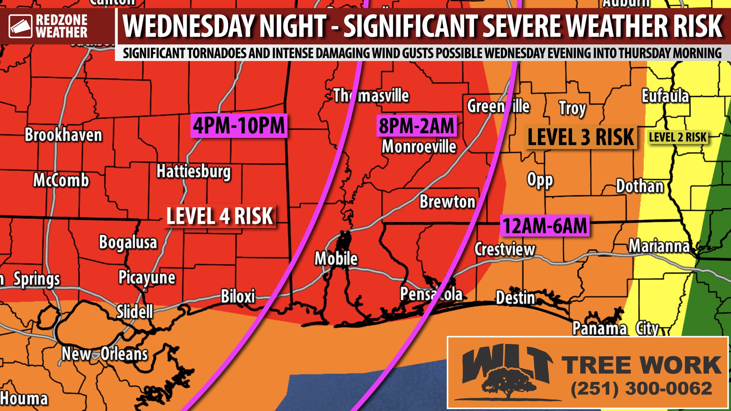
STRONG TORNADOES & DAMAGING WIND RISK ON WEDNESDAY NIGHT… Wednesday evening into early Thursday morning is when a line of strong to severe thunderstorms is expected to move across south Alabama and northwest Florida, bringing with it a significant tornado potential along with a heightened potential for damaging straight line winds. This line of storms could be particularly intense, knocking down trees and power lines across parts of our region. The Storm Prediction Center continues to include much of our local area in their Level 4 (out of 5) severe weather risk zone, meaning this is a substantial risk. It is imperative that we all have a way to get urgent weather warnings (tornado warnings AND severe thunderstorm warnings) tomorrow evening into Thursday morning. We all need a device that can be LOUD and wake us up if a warning is needed for our specific location. A few more Tuesday evening forecast notes are below.
SEVERE WEATHER TIMING – WEDNESDAY INTO THURSDAY… Wednesday evening into early Thursday morning remains the primary severe weather risk will likely set up across south Alabama and northwest Florida. 6PM Wednesday to 6AM Thursday is the 12 hour window when severe weather threat will likely maximize across our area. 9PM to 3AM looks to be the 6 hour “core risk” window for local areas. Again, please have a way to get warnings Wednesday night. We all need a device that can wake us up if a tornado warning is needed locally.
STRONG TORNADOES POSSIBLE… Fast-moving tornadoes will be possible on Wednesday evening into early Thursday, not only in discrete, isolated storms out ahead of the main batch of storms but also in the main line of storms set to move through our region in the overnight hours. Some of these tornadoes may be significant or strong (EF2+). To be clear, these tornadoes may be powerful and be on the ground for many miles. It is so important to have a way to get tornado warnings tomorrow into tomorrow night!
DAMAGING WIND RISK ACROSS LOCAL AREA… I am particularly concerned about the potential for a widespread, damaging wind event across Mississippi, Alabama, and northwest Florida setting up for Wednesday night. The main line of strong to severe thunderstorms slated to move across our region could be particularly intense, knocking down trees and power lines in some areas. Tomorrow will be a day when we all need to have our phones, tablets, and computers charged ahead of the potential for isolated power outages. This is something simple that we all can do ahead of this severe weather potential – make sure your devices are charged and ready.
LEVEL 4 (OUT OF 5) RISK EXPANDED TODAY… The Storm Prediction Center expanded the Level 4 (out of 5) severe weather risk zone to include a large chunk of our local area in southwest Alabama and northwest Florida. The truth is, regardless of which specific color/number your community is involved in, we ALL have a significant risk of severe storms setting up for Wednesday into early Thursday. Forget about the color/number/risk zone, just know we all have a substantial risk that is quite uncommon, even for this time of year in the heart of severe weather season. A Level 4 (out of 5) risk means that widespread severe thunderstorms are likely, including some that may be particularly intense and/or long-lasting. This Level 4 risk is driven by the heightened potential of strong tornadoes (EF2+) AND by the potential for a widespread, damaging wind event. Take severe thunderstorm warnings just as seriously as tornado warnings tomorrow night!
TORNADO WARNING POLICY… Any time there is an active tornado warning in effect for southwest Alabama or northwest Florida, we provide uninterrupted, live video coverage on Facebook Live and in the RedZone Weather app. Our detailed coverage commitment is outlined at redzoneweather.com/coverage. We are proud to cover all parts of Escambia (AL), Covington, Monroe, Conecuh, Baldwin, Mobile, Clarke, Washington, Butler, Escambia (FL), Santa Rosa, and Okaloosa counties. If you live in any locale in those counties, be sure to tune into our coverage whenever there is an active tornado warning!
APP ALERTS… Many updates will be posted over the next few days in the RedZone Weather app. redzoneweather.com/app is the link for the free download. Be sure to visit the Alerts tab (bottom right corner) and tap the large, yellow “Alert Settings” button to customize the alerts you’d like to receive from me. If you like a lot of info, be sure to toggle ON Low-Level Alerts.
I will have more updates throughout the night and into tomorrow in the RedZone Weather app. As always, we will “go live” on Facebook and across our platforms when we have tornado warnings tomorrow night. Have a good Tuesday evening!


