
3 DISTINCT ROUNDS OF STRONG STORMS AHEAD; FIRST ROUND OVERNIGHT… Buckle up! We have not one, not two, but 3 rounds of active weather ahead over the next few days. The first round of rain and thunderstorms will move across south Alabama and northwest Florida in the overnight hours tonight into early Thursday morning. 1AM to 9AM continues to be the 8 hour window when strong to severe storms are most likely to happen. Please have a way to get warnings overnight, preferably something loud that can wake you up if your specific location happens to go under a tornado warning. We get a break from active weather on Thursday afternoon ahead of more rain and storms during the daytime hours on Friday. The rain and storms on Friday will serve as Round 2 of 3. The main concerns Friday will be gusty winds and hail in the stronger storms. Then, on Saturday, we could have a potentially more significant round of severe weather in Round 3 of 3, specifically in the afternoon hours.
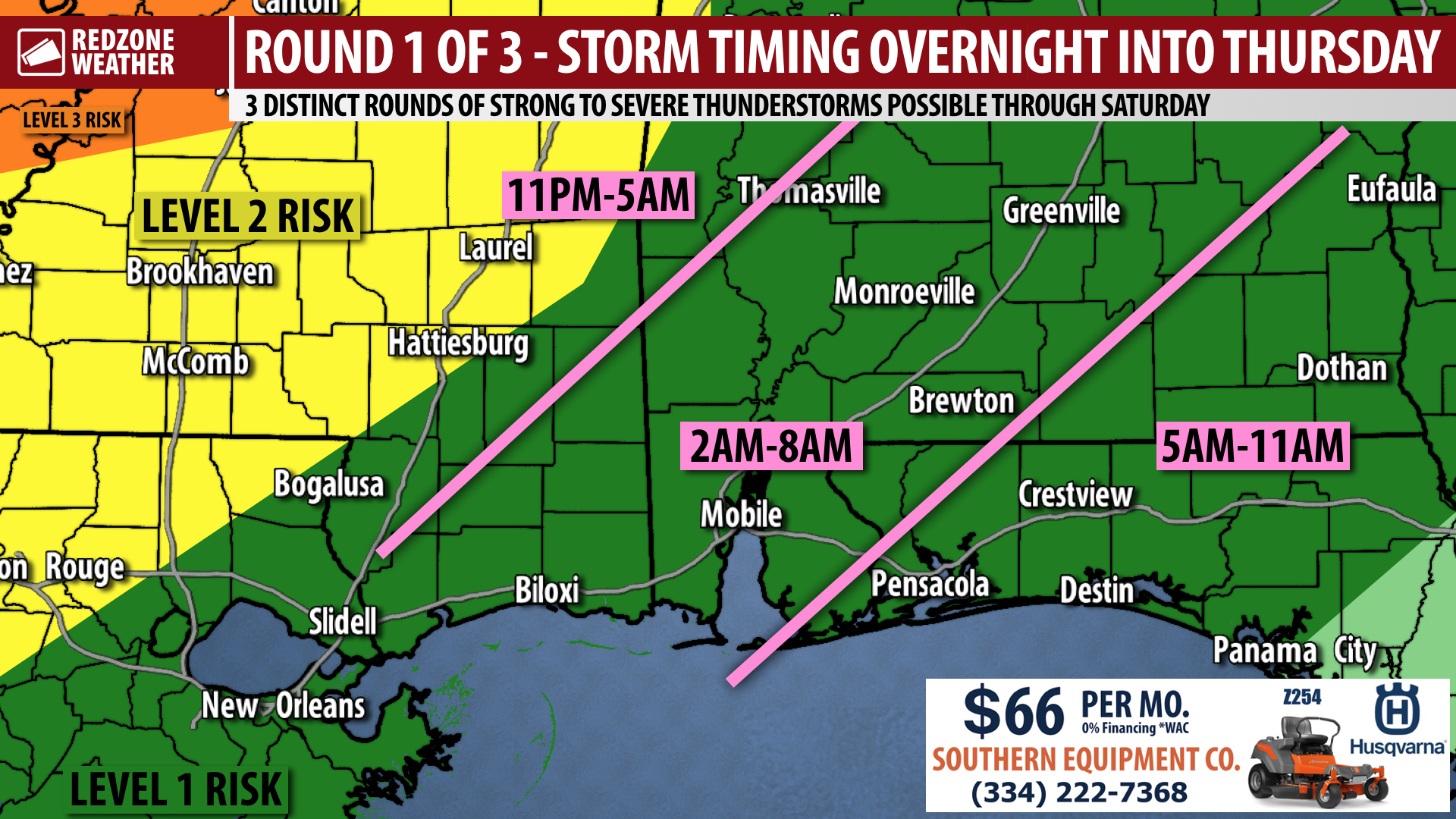
ROUND 1 OF 3 – STORMS OVERNIGHT INTO THURSDAY… We are tracking a cluster of thunderstorms that extends from north to south along the Mississippi River into parts of Louisiana at the time I am producing this update around 7:30PM. This band of rain and storms will continue to move east and southeast in the hours ahead, likely reaching the Alabama-Mississippi state line in southwest Alabama around 2-3AM. Storms will likely be weakening somewhat by that point, but there remains a low-end, Level 1 (out of 5) severe weather risk for our entire local area in south Alabama and northwest Florida. This risk is in place due to the low-end potential for a few of the storms to be on the strong side, with damaging wind gusts being the main concerns. The overall tornado risk overnight into Thursday morning remains low, but not at zero. Storms will cross our area and clear out to the east late tomorrow (Thursday) morning.
SEVERE WEATHER TIMING – OVERNIGHT… The first window (out of 3 specific time frames!) for strong storms across south Alabama and northwest Florida will be from 1AM to 9AM on Thursday. That is TONIGHT in the overnight hours. This eight hour window mostly happens in hours before sunrise, thus it is important we all have a way to get warnings before we go to sleep tonight. We need something that can wake us up, aka a device that is loud like a NOAA Weather Radio. Cell phones with Wireless Emergency Alerts (WEAs) enabled are also a great tool.
ROUND 2 OF 3 – FRIDAY STORMS… Thunderstorms on Friday will be more scattered in nature compared to the other rounds of storms on Thursday morning and on Saturday. I suspect the main concerns on Friday will be heavy rain, gusty winds, and hail in the stronger storms. The overall tornado risk on Friday seems quite low. It’s not at zero, but the risk seems very low for tornadoes on Friday.
ROUND 3 OF 3 – STORMS ON SATURDAY… Based on the latest guidance, it certainly seems like Saturday could end up being the most significant round of thunderstorms locally with a chance of strong to severe storms, primarily in the daytime hours. There remains quite a bit of forecast uncertainty, with certain models showing a later arrival of storms (in the afternoon) that would be stronger. Some other models, however, point to an earlier arrival of storms in the morning hours. Under that scenario, storms would be weaker. Regardless of which scenario pans out, I would encourage you to keep tabs on the setup for Saturday. Please check back in over the next few days for updates as there is a chance this could potentially be a significant round of severe weather, at least under some scenarios. I will keep monitoring the data and bring you the latest in the RedZone Weather app.
RAIN TOTALS THROUGH SUNDAY… Most locales will have 2.5 to 3.5 inches of rainfall in total through Sunday with the greatest chance of rain being on Thursday morning then again on Saturday. Intermittent heavy rain will be possible at times. The local National Weather Service is considering placing at least part of our local area in a Flash Flood Watch due to the high rainfall potential.
NICER WEATHER SUNDAY INTO MONDAY… Rain chances lessen and at least some sunshine is expected on both Sunday and Monday. High temperatures will remain near 80 each day with morning lows in the 60s.
SET UP APP ALERTS… We send quite a bit of Low-Level Alerts in our RedZone Weather app. The app is totally free for you! redzoneweather.com/app is the link where you see the download links to your respective app store for iOS and for Android devices. Once you have the app downloaded to your smartphone or tablet device, be sure to visit the Alerts tab to customize the alerts you would like to receive straight from me.
NEXT VIDEO IN A.M. UNLESS TORNADO WARNING NEEDED OVERNIGHT… I will have your next regularly scheduled forecast video posted by 7:15AM tomorrow (Thursday) morning unless we have to go into uninterrupted live video coverage for tornado warnings overnight into the early part of Thursday morning. redzoneweather.com/coverage outlines our detailed tornado warning commitment.
Have a nice Wednesday evening!


