
We get a break from the rain through Wednesday ahead of a more active pattern toward next weekend. https://t.co/rNgxHkTOEa
Tap below to support this RZW sponsor!


We get a break from the rain through Wednesday ahead of a more active pattern toward next weekend. https://t.co/rNgxHkTOEa

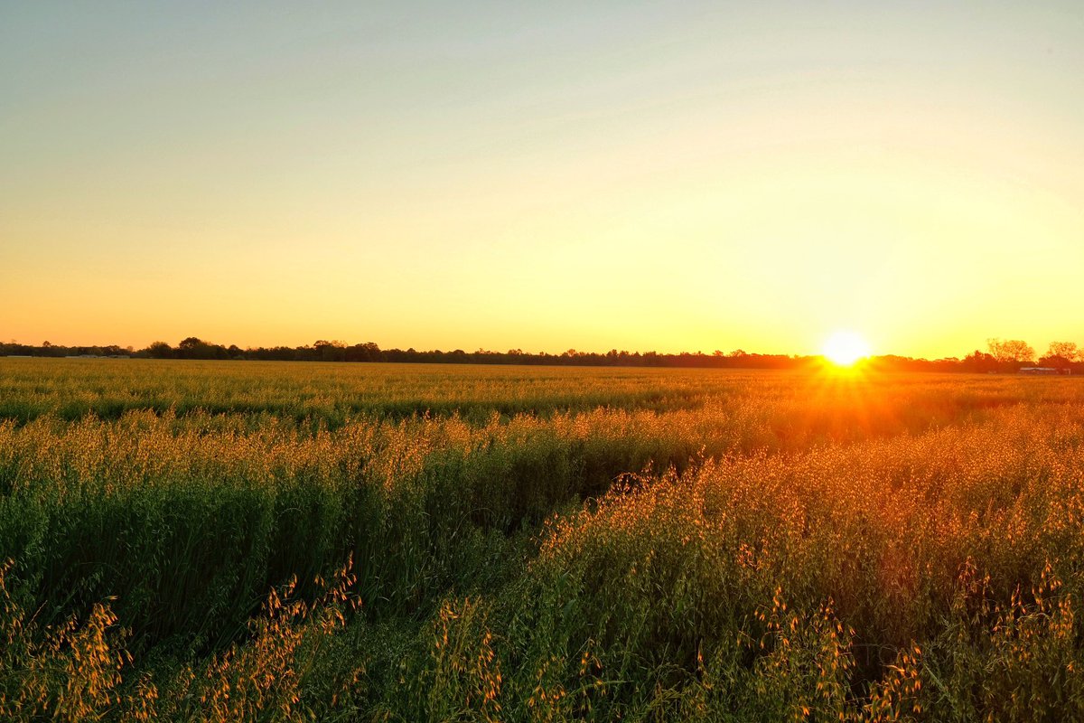
SUNNY SKIES TO START THE WEEK… Sunshine and warm temperatures are ahead not only on this Monday but also over the next few days. High temperatures today will be in the low- to mid-80s with plenty of sunshine throughout the day. Get outside and enjoy the nice weather today and tomorrow if you can! We have rain ahead toward the end of the week. Scattered showers will return late Thursday into Friday and Saturday. A few more Monday morning forecast notes are below.
FEW CLOUDS TUESDAY INTO WEDNESDAY; WARM TEMPS… Other than a few passing clouds, Tuesday is slated to be quite nice. We’ll call it mostly sunny skies with highs in the mid-80s. Other than a few more clouds around our region on Wednesday, midweek looks dry and nice. Highs on Wednesday will again be in the mid-80s.
SHOWERS POSSIBLE THURSDAY INTO FRIDAY… Rain will become possible yet again on Thursday out ahead of a decaying frontal boundary. Scattered showers will be possible Friday into Saturday, but there is a good chance neither day will be an “all day washout.” High temperatures later this week will remain in the low-80s.
RAIN AROUND THIS WEEKEND… Early model guidance points to a chance of rain and thunderstorms on Sunday, although forecast confidence is fairly low in that timeframe. Saturday also could feature a few widely scattered showers. We’ll keep watching the data this week and bring you the latest in the RedZone Weather app.
10 YEAR ANNIVERSARY OF APRIL 27 TORNADO OUTBREAK TOMORROW… Tomorrow (Tuesday, April 27, 2021) marks the 10 year anniversary of the historic April 27, 2011 super outbreak of tornadoes that affected so many people across the Deep South, particularly in Alabama. 252 people lost their lives on that day due to tornadoes in the state of Alabama alone. Thousands were injured in 62 tornadoes that happened across the state on that day. Several of those tornadoes were long-track, violent, large tornadoes that directly affected many locales. The outbreak featured multiple EF5 tornadoes that struck the northern parts of Alabama. Tomorrow, we remember all the people we lost on that day.
APP… Be sure to download our free RedZone Weather app if you haven’t done so already. redzoneweather.com/app is the link where you can download the app for your iOS or Android device. Once you have the app downloaded, be sure to visit the Alerts tab in the lower right corner of the app to select the specific notifications you would like to receive straight from me.
See all the details in your Monday #rzw forecast video. Have a great start to your week!


? Fantastic weather is ahead as we start another work week! Highs on this Monday will be in the low-80s. Have a great day! https://t.co/DhqkiYcRt0


Moonrise Atmore,Al @spann @NWSMobile @rzweather @StormHour @ThomasGeboyWX @michaelwhitewx @KDanielCCI @WKRGEd #alwx #moon https://t.co/Ra2aMoZtVW


Beautiful day across much of the Deep South! Temps are in the mid-70s this afternoon. Enjoy your Sunday! ☀️ https://t.co/dEoqGIUzVW


Sunday sunrise Atmore,Al @spann @NWSMobile @rzweather @StormHour @ThomasGeboyWX @michaelwhitewx @KDanielCCI @WKRGColleen @mynbc15 #alwx https://t.co/uUCvgcAUrS
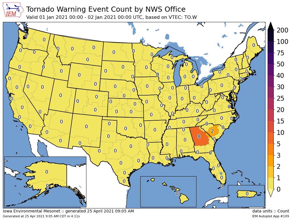
After yesterday, @NWSTallahassee has issued the 2nd most Tornado Warnings of any office so far in 2021. Current list:
1. Birmingham
2. Tallahassee
3. Memphis
4. Jackson
5. Mobile
Here’s the weekly evolution of this distribution, showing the classic early-year focus over the SE. https://t.co/d6xwyGsKaJ

?☀️Sunshine returns on this Sunday. High temperatures will be near 80 degrees this afternoon.
Have a great day!
ALL CLEAR: LONG DAY OF SEVERE WEATHER ENDS… I’m thrilled to give a total ALL CLEAR to all parts of south Alabama and northwest Florida now that the risk of severe storms has ended. The tornado risk is now over across all of our local counties in southwest Alabama and northwest Florida.
What a day! Numerous trees were downed this morning along with several structures damaged due to an intense line of thunderstorms. Then, this afternoon into this evening, we had multiple tornado-warned storms and very large hail, up to the size of a baseball in some cases.
BECOMING SUNNY ON SUNDAY… Sunshine is set to return tomorrow (Sunday). High temperatures will be around the 80 degree mark. Monday and Tuesday will also be sunny ahead of higher rain chances later in the week.
Have a good evening!
ALL CLEAR! The severe weather risk has ended across south Alabama and northwest Florida. Sunshine returns on Sunday! ☀️ https://t.co/KAG1WB1T9R


Storm structure and wind damage in West Mobile, AL.
@NWSMobile @WKRGEd @spann @rzweather @ThomasGeboyWX @AlanSealls @mynbc15 @WKRG @FOX10News https://t.co/D21D4zf3RP

@rzweather After the storm came beauty in the sky with the moon https://t.co/N6U6qkUyHH

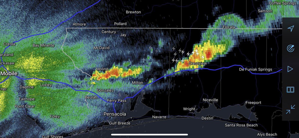
These are the last of the storms for today. Loud and proud storms are happening near Crestview, Baker, and Deerland. Downpours also happening near Milton, Pace, and Gonzalez.
All clear for entire region coming very soon. https://t.co/62lmTCQxiA

Double ? Atmore,Al @spann @NWSMobile @rzweather @StormHour @ThomasGeboyWX @michaelwhitewx @mynbc15 @KDanielCCI @wkrgcaroline #alwx #rainbow https://t.co/PVJMpiusx6

ALL CLEAR COMING SOON… While I cannot give a complete “all clear” to our entire region, we are definitely getting close to that point. I imagine we will be able to give an all clear around 9PM to all local counties. As of 7:45PM, noisy storms are happening across parts of Escambia (FL), Santa Rosa, and Okaloosa counties. Severe storms are also happening near Opp in eastern Covington County.
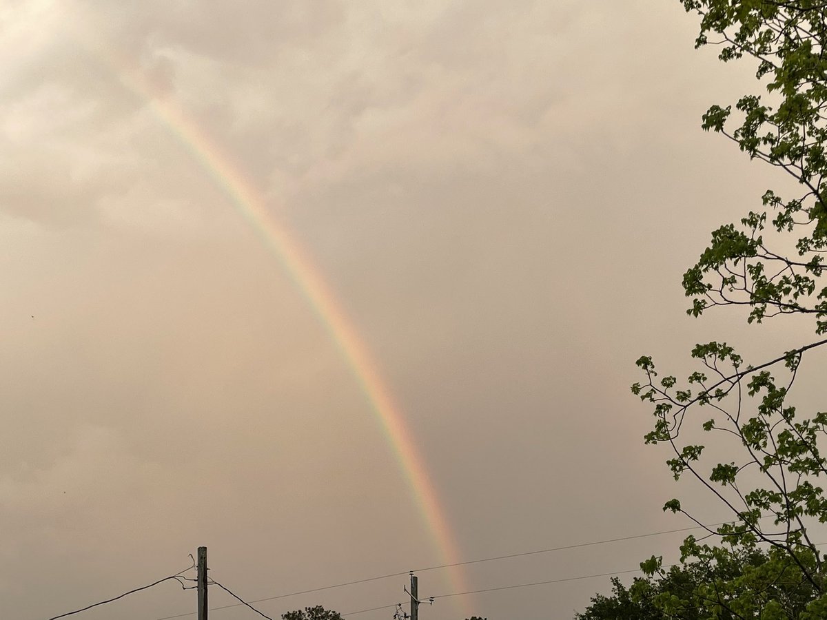


Rainbow and clouds over Atmore. ?☁️
@NWSMobile @spann @rzweather @michaelwhitewx @ThomasGeboyWX @WKRGEd @AlanSealls @StormHour @ThePhotoHour #alwx #rainbow https://t.co/jN0G8gYuu7

Rainbow over Atmore,Al @spann @NWSMobile @rzweather @StormHour @ThomasGeboyWX @michaelwhitewx @Darwin_WPMI @KDanielCCI @WKRGEd #alwx #rainbow https://t.co/eU40TJ4lIL


Hwy 97 in Molino looking Northwest @rzweather https://t.co/Tf8JBeBasU

Severe Thunderstorm Warning for Coffee, Dale, Geneva and Houston County in AL until 8:15pm.

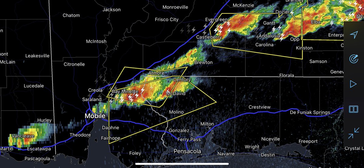
Severe Thunderstorm Warning polygons are now in effect until 7:45PM for Andalusia, Opp, Gantt, Carolina, Brooklyn, Bay Minette, Molino, Walnut Hill, McDavid, Chumuckla, Gateswood, Daphne, Fairhope, Spanish Fort, and Loxley. Hail is the main concern, but gusty winds also possible. https://t.co/0LOs0FFm1M

Hail in River Falls, AL @spann @TylerSmith_wx @ThomasGeboyWX @rzweather @SchlobohmAsa https://t.co/bkTG3Nib6y

Leading edge of the storm currently moving across Covington County near Andalusia and Opp. Photo from Russell Craig. https://t.co/ConRhVzPeE


