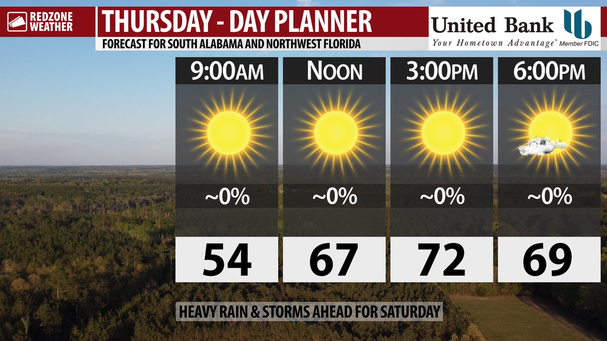
NICE THURSDAY; STRONG STORMS POSSIBLE ON SATURDAY… Gorgeous weather is in store today, but our focus is increasingly on Saturday when a round of strong to severe thunderstorms may happen across our region. The Storm Prediction Center continues to include all of our local area in their severe weather risk zones, meaning all severe weather hazards will be possible locally on Saturday. This includes the potential for tornadoes, damaging wind gusts, large hail, and flash flooding. There may be multiple rounds of rain and storms on Saturday, one happening in the early morning hours, followed by another, more significant round of storms in the afternoon and evening hours. Please have a way to get urgent weather warnings before you go to sleep Friday night and of course on Saturday during the “main event.” The good news is this will be a “quick hitting” system that moves out early Sunday morning. More sunshine is ahead for early next week. Your full Thursday morning forecast details are below.
PERFECT WEATHER TODAY… Picture perfect weather is ahead for south Alabama and northwest Florida on this Thursday. High temperatures will be in the low-70s this afternoon after our chilly start this morning. Temperatures dipped into the low-40s in many spots. Full sunshine is expected throughout the day.
INCREASING CLOUDINESS FRIDAY… Clouds will increase on Friday ahead of a few, small showers becoming possible in the late evening hours. I expect the vast majority of the daytime hours of Friday to be dry. Highs on Friday will be in the mid-70s.
SEVERE WEATHER TIMING – SATURDAY… Two distinct rounds of heavy rain and strong storms may happen on Saturday. The first round of heavy rain will feature a lower-end severe weather risk on Saturday in the early morning hours, probably from 2AM to 7AM. This round of rain and storms may be under severe limits. These first storms will be firing up along a warm front that will be moving north across the region. The next, potentially more significant round of thunderstorms will likely fire up in the late morning hours and extend into the afternoon and evening hours. 11AM to 8PM will be when the second and final round of thunderstorms will be ongoing. There is a chance our area may get an “all clear” well before 8PM, but I cannot guarantee that. We will be able to resolve some of the specifics regarding timing as we get closer to the event.
TORNADOES, DAMAGING WINDS, LARGE HAIL POSSIBLE SATURDAY… Every severe weather event is unique, but the situation setting up for Saturday is a classic April severe weather setup for the Deep South. This means that tornadoes, damaging wind gusts, large hail, and flash flooding will all be possible in the strongest of the storms. The greater tornado risk may set up farther inland, particularly in our inland counties and points north, in the afternoon and evening hours of Saturday.
CLEARING SKIES SUNDAY… Rain should be gone by the very early morning hours of Sunday and clouds should fade away by the late morning hours of Sunday, meaning the afternoon and evening hours will likely be dry and nice. Temperatures will be near 80 degrees on Sunday afternoon.
SUNSHINE EARLY NEXT WEEK… Monday and Tuesday of the upcoming week are expected to be dry with high temperatures in the low-80s. Plenty of sunshine is expected each day. Clouds will likely begin to increase in coverage late in the evening hours on Tuesday.
ANOTHER ROUND OF STORMS MIDWEEK… Early model guidance points to another round of rain and thunderstorms perhaps Wednesday into Thursday of the upcoming week. Some severe weather may accompany this system, particularly in areas to our northwest across parts of Louisiana, Arkansas, and Mississippi. It is too early to know if strong storms will be possible locally, but that is something we will be monitoring over the next few days. Let’s get through the round of rain and storms Saturday, then we can shift our focus to midweek.
APP… If you haven’t already, be sure to download the free RedZone Weather app to keep up with all the latest information on the world of weather in south Alabama and northwest Florida. redzoneweather.com/app is the link for the free download. Once you have the app downloaded to your iOS or Android device, be sure to visit the Alerts tab (lower right corner) and tap the large, yellow Alert Settings button to customize the alerts you would like to receive straight from me.
See all the details in your Thursday #rzw forecast video. Have a great day!
Tap below to support this RZW sponsor!


