Saturday is the day to watch with severe storms, heavy rain, and flash flooding becoming possible across our region. https://t.co/U4Q2u5L8CI

Saturday is the day to watch with severe storms, heavy rain, and flash flooding becoming possible across our region. https://t.co/U4Q2u5L8CI
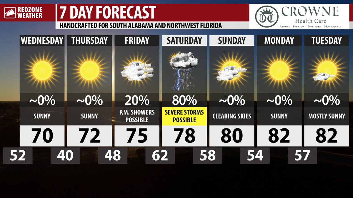
SUNNY TODAY; COLD NIGHT AHEAD; STRONG STORMS POSSIBLE SATURDAY… Sunshine is the story on this Wednesday ahead of abnormally cold temperatures tonight. We are also looking ahead to Saturday when scattered strong to severe thunderstorms may be possible across our entire area, perhaps including a few tornadoes. Before the severe weather risk sets up on Saturday, we have nice days upcoming today and on Thursday. High temperatures on this Wednesday will be in the upper-60s farther inland with low-70s closer to the Alabama and northwest Florida beaches. Unseasonably cool temperatures are ahead for the overnight hours ahead of a quick rebound on Thursday. I’ve got your full Wednesday morning forecast details below.
CLEAR SKIES OVERNIGHT; LOWS NEAR 40 BY DAYBREAK… Clear skies tonight will allow temperatures to quickly fall into the 40s by 10PM in most spots. I expect the vast majority of communities near and just north of U.S. Highway 84 to briefly dip to 40-42 degrees by daybreak on Thursday. Some communities like Thomasville, Beatrice, and Greenville could briefly dip into the upper-30s. Closer to the local beaches, mid-40s are expected by sunrise on Thursday.
SUNSHINE ON THURSDAY… Temperatures will quickly rebound into the low-70s tomorrow after the cold temperatures in the morning hours. Full sunshine is expected throughout the day on Thursday.
CLOUDS INCREASE FRIDAY; SHOWERS LIKELY LATE… Cloud coverage will increase on Friday and there is a chance we may have showers and perhaps a few thunderstorms late in the day. The greatest chance of rain and storms Friday evening will happen across southwest Alabama, particularly in areas along and west of Alabama River. We are not expecting widespread severe thunderstorms on FRIDAY, but Saturday will likely be a different story with widespread rain and storms becoming likely. A few stronger storms may happen Friday evening as a warm front lifts northward and crosses our area, but I think the bigger issues are ahead for Saturday.
STRONG TO SEVERE STORMS POSSIBLE SATURDAY… Strong to severe thunderstorms will be possible across the entirety of south Alabama and northwest Florida on Saturday. All severe weather hazards, including tornadoes, damaging straight line winds, large hail, and heavy rain that could lead to flash flooding, will be possible. It is impossible to nail down specifics this far in advance, but it certainly appears much of the daytime hours of Saturday could have rain and thunderstorms around.
ALL MODES OF SEVERE WEATHER POSSIBLE… Please have a way to get urgent weather warnings on Saturday. I have had several questions about specific events in specific cities and towns across the region. At this point, there simply is no way to be specific on the hazard placements. Model guidance continues to show a strong signal that supports a severe weather potential, but it is next to impossible to know exactly where the specific tornado risk will set up until we get closer to the event. I imagine we will have a much better grasp of the hazard potential by the time we get to Thursday evening and Friday morning.
SEVERE WEATHER RISK FOR THE ENTIRE LOCAL AREA… The Storm Prediction Center continues to include all of south Alabama and northwest Florida in their severe weather risk zones valid for Saturday. This means that severe weather hazards, including a tornado potential, will be possible.
HEAVY RAIN & FLASH FLOODING RISK… In addition to the convective hazards (tornadoes, damaging wind, hail), a considerable risk of flash flooding may set up, especially in coastal counties, on Saturday. Rain amounts from last week and the last weekend were greater in the southern half of our local area, aka closer to the coast, thus the soil in these counties remains more saturated compared to areas farther inland. Rain amounts of 1-3″ in total will be common across the region with this event ahead on Saturday. I would not be surprised to see a Flash Flood Watch issued in the days ahead, particularly for coastal communities.
CLEARING SKIES SUNDAY & EARLY NEXT WEEK… Rain clears out late Saturday ahead of clouds moving out early Sunday morning. There is a high chance Sunday will feature clearing skies with warm temperatures. Highs on Sunday will be in the low-80s. Sunshine is expected on Monday and Tuesday of the upcoming week.
APP… If you haven’t already, be sure to download the free RedZone Weather app to keep up with all the latest information on the world of weather in south Alabama and northwest Florida. redzoneweather.com/app is the link for the free download. Once you have the app downloaded to your iOS or Android device, be sure to visit the Alerts tab (lower right corner) and tap the large, yellow Alert Settings button to customize the alerts you would like to receive straight from me.
See all the details in your Wednesday #rzw forecast video. Have a great day!

☀️ Sunny skies and cool temperatures are expected across south Alabama and northwest Florida on this Wednesday. High temperatures will peak near 70. Enjoy the day! https://t.co/pgRmOHOKt2

STRONG TO SEVERE STORMS & HEAVY RAIN POSSIBLE SATURDAY… Tornadoes and damaging winds will become possible across our local area on Saturday as a dynamic weather system moves across the Deep South. In addition to the tornado and damaging wind threat, large hail may be possible. Heavy rain that could lead to flash flooding will be possible as well. It is a bit too early to determine specifics on where hazards are most likely to happen. It also is a bit early to be able to know when storms will be most likely to happen. One round of storms may happen Friday in the late evening hours along a warm front. The bigger, more significant round of severe storms will probably happen Saturday during the daytime hours. This is an evolving situation with forecast changes being likely over the next few days. Please have a way to get severe weather warnings on Saturday and please check back for updates over the next few days.
LEVEL 2 (OUT OF 5) RISK FROM LOUISIANA TO GEORGIA… The Storm Prediction Center has included parts of eastern Louisiana, southern Mississippi, the southern half of Alabama, all of northwest Florida and the Florida Panhandle region, and southwestern Georgia in their Level 2 (out of 5) severe weather risk valid for Saturday, April 24. We note that this risk zone includes ALL of our local counties in south Alabama and northwest Florida, both coastal and inland counties. This means that ALL of us need to have a way to get urgent weather warnings on Saturday.
TIMING UNCLEAR – SPECIFICS IN THE DAYS AHEAD… Take this post as a “first alert” for the severe weather potential setting up for Saturday. I wish we could be super specific as far as what cities and towns have the greatest hazard potential. Unfortunately, model resolution 4-5 days out simply does not exist, thus it is near impossible to speculate in any accurate way. Please check back in over the next few days as we continue to get more data to be able to fine tune the forecast. Better data will give clarity Thursday evening into Friday as we look to this severe weather setup on Saturday.
APP ALERTS… Now is the time, long before we get to this severe weather potential, to set up the RedZone Weather app on your smartphone! redzoneweather.com/app is the link where you can download the iOS or Android version of the app. Once you have the app downloaded to your device, be sure to visit the Alerts tab (lower right corner of the app), then tap the large, yellow Alert Settings button to customize the alerts you would like to receive straight from me.
I will have your next full forecast video posted by 7:15AM Wednesday.