Gorgeous day across the Deep South! Hardly any clouds over Alabama and northwest Florida as of midday Friday! https://t.co/dX8OrTXWKK

Gorgeous day across the Deep South! Hardly any clouds over Alabama and northwest Florida as of midday Friday! https://t.co/dX8OrTXWKK

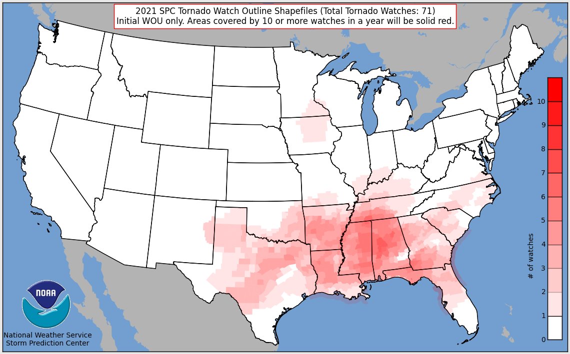
Tuscaloosa, Hale, Bibb, and St. Clair counties lead the nation in the number of tornado watches issued so far in 2021.
The vast majority of the tornado watches are in “Dixie Alley” so far this year. https://t.co/JbvCiHG87Y

Enjoy the weekend as we have another active few weather days ahead early next week (cue the groans, me too!). https://t.co/sPX9yvMQrp
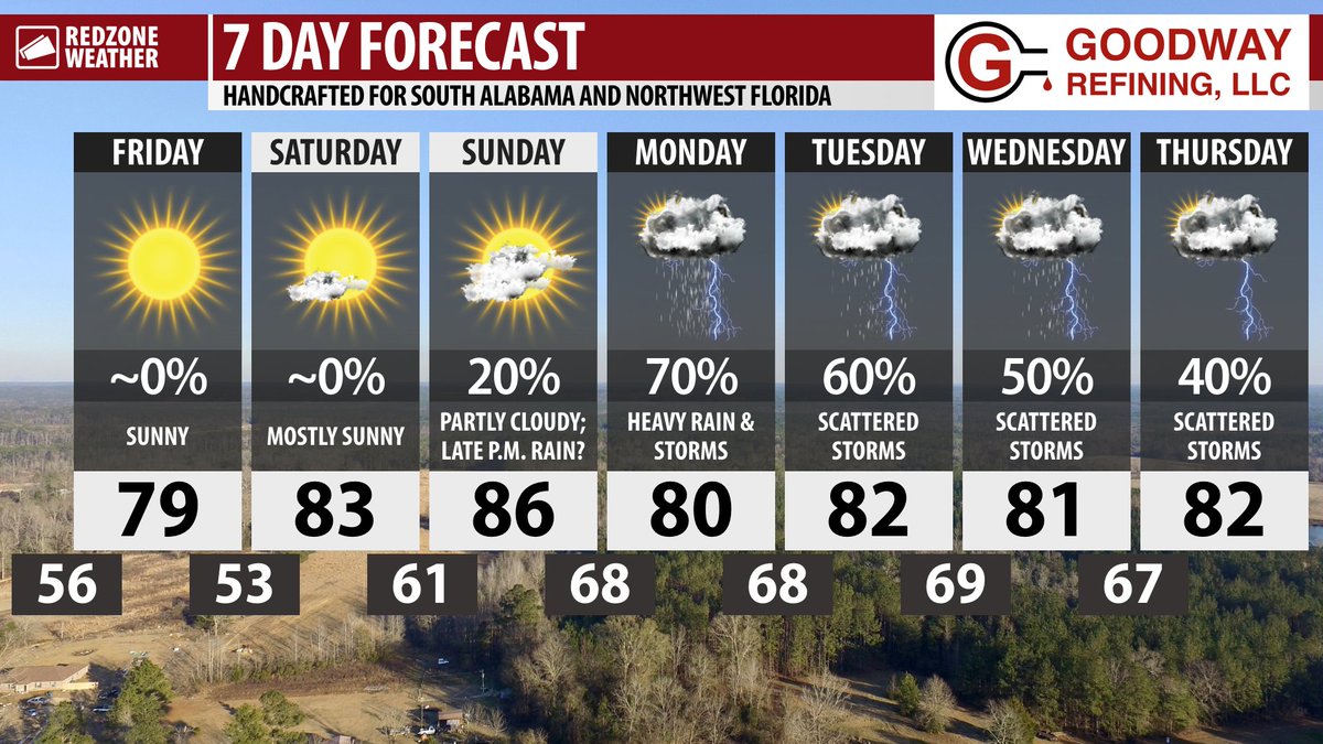
SUNNY FRIDAY; SUNNY WEEKEND; RAIN & STORMS RETURN MONDAY… Sunshine is expected today, tomorrow, and on Sunday in what is slated to be our nicest weekend in quite some time. High temperatures today will be near the 80 degree mark with full sunshine expected throughout the day. This weekend will be near perfect, with highs in the 80s with sunny skies on Saturday and mostly sunny skies on Sunday. Rain and storms are set to come back into our weather forecast on Monday into Tuesday.
PICTURE PERFECT WEEKEND… After multiple weekends with heavy rain, storms, and general unsettled weather, this weekend will be the opposite! We get a full weekend of sunshine with only limited amounts of passing clouds on Sunday. High temperatures will be in the mid-80s on Saturday with mid- to upper-80s expected on Sunday. If you’re headed to the beach or going to be outside for an extended period of time this weekend, please grab the sunscreen! The UV index will be quite high (9-10+).
RAIN & STORMS LIKELY AT TIMES MONDAY… Rain and thunderstorms are likely on Monday as an area of low pressure develops to our northwest. This area of low pressure will cause a trailing front to move near our area that will ultimately stall out, sparking off a large chance of showers and storms on Sunday. Thunderstorms will be possible, including perhaps a low-end chance of a few stronger storms with gusty winds and small hail being the main concerns.
UNSETTLED PATTERN NEXT WEEK… Tuesday through Thursday of the upcoming week will probably feature scattered showers and thunderstorms at times. High temperatures will be in the low-80s. It is too early to know if severe storms will be possible in that particular timeframe. Forcing from an advancing front likely won’t be present, thus it looks like any potential for severe weather would be limited.
TRENDING DRIER LATE IN THE WEEK… Early model guidance points to potentially drier conditions by Friday (a week from today) into Saturday. High temperatures will likely remain in the 80s late next week into that weekend.
A NOTE ABOUT HURRICANE SEASON… RedZone Weather will generally include at least one paragraph in each morning weather discussion concerning the latest tropical activity in the Atlantic Basin (including the Gulf of Mexico, Caribbean Sea, and Atlantic Ocean) beginning on Saturday, May 15 (one week from tomorrow). While hurricane season does not officially kick off until June 1, the National Hurricane Center will begin issuing routine tropical weather outlooks beginning on May 15 due to the last several years having preseason tropical storms. We will include at least one paragraph in each morning discussion concerning the tropics even if only to indicate no development is expected, as many folks are interested in the tropics. For now, the tropics are quiet with no tropical storm formation expected over the next 5 days. Good news! Let’s keep it that way for awhile.
APP… Be sure to download our free RedZone Weather app if you haven’t done so already. redzoneweather.com/app is the link where you can download the app for your iOS or Android device. Once you have the app downloaded, be sure to visit the Alerts tab in the lower right corner of the app to select the specific notifications you would like to receive straight from me.