Halo around the Moon on Christmas Night 2023 as viewed from Brewton, Alabama… pic.twitter.com/NRoWihWylq
— Spinks Megginson (@rzweather) December 26, 2023
Tap below to support this RZW sponsor!


Halo around the Moon on Christmas Night 2023 as viewed from Brewton, Alabama… pic.twitter.com/NRoWihWylq
— Spinks Megginson (@rzweather) December 26, 2023
Although a cold front has passed through the area, and taking the rain with it, temperatures tonight will remain mild. Overnight lows northwest of I-65 this Christmas Night will be about 4 to 7 degrees above normal, and 7 to 14 degrees above normal to the southeast. pic.twitter.com/m9YtqMAboy
— NWS Mobile (@NWSMobile) December 26, 2023

Merry Christmas, y’all! 🎄
Sunset from Atmore. It kept getting prettier the longer I waited. 😍🌅 @NWSMobile @spann @rzweather @michaelwhitewx @KNBHwx @ThomasGeboyWX @WKRGEd @AlanSealls @KDanielCCI @StormHour @ThePhotoHour #ALwx pic.twitter.com/m8oTr2hsBI— 𝚋𝚛𝚒𝚝𝚝𝚊𝚗𝚢 𝚐𝚒𝚕𝚋𝚎𝚛𝚝 (@brittykat94) December 25, 2023

After the rain and storms this morning, it really has turned out to be a nice Christmas Day across the region. Temperatures remain in the low-70s at 4:13PM. Nice! pic.twitter.com/31aq0fJYv6
— Spinks Megginson (@rzweather) December 25, 2023

@rzweather Additional 8/10 inch of rain fell in North Crestview Florida on Christmas day Monday 12-25-2023 for a total rainfall of 1.06 inches from this system. Wind gusted to 40 MPH at 09:00AM.
— Car 412 (@HRickover) December 25, 2023

Rain and thunderstorms continue to exit Alabama and northwest Florida to the east. Thunderstorms are happening near Samson, Geneva, and Dothan at 2PM.
Temperatures are in the low-70s across the region this afternoon. Quite nice for Christmas Day! pic.twitter.com/UkxsxSBcx9
— Spinks Megginson (@rzweather) December 25, 2023

Merry Christmas! We are flying single red flags 🚩 in Orange Beach today – Monday, December 25th. Single red flags represent High Hazard with High Surf and/or Strong Currents. For your safety we ask that you stay on the shore. Morning view: Romar Beach. @spann #alwx pic.twitter.com/bk7RjaU8jk
— City of Orange Beach (@cityorangebeach) December 25, 2023

11 Years Ago:
Christmas Day 2012 Gulf Coast Tornado OutbreakA widespread and significant outbreak of severe weather impacted the Central Gulf Coast states on Christmas.
Multiple significant & long-tracked tornadoes. Remarkably, no fatalities were reported, but over 30 injuries… pic.twitter.com/EeiXPLhIKb— Weather Track US (@weathertrackus) December 25, 2023
Beautiful Christmas Day in Mobile, AL. Warm at 70 degrees. Merry Christmas everyone!@rzweather @marcusreynold19 @WKRGEd @spann @NWSMobile pic.twitter.com/kjyCPYd8BA
— Tyler Smith (@TylerSmith_wx) December 25, 2023
@rzweather 3/10 inch (.26 on the machine) of rain fell in North Crestview Florida overnight Sunday 12-24-2023 to Monday 12-25-2023. Merry Christmas.
— Car 412 (@HRickover) December 25, 2023

It’s not yet noon in lower Alabama but we’re at 72°. We had one and three-quarter inches of rain.
Am I the only one who didn’t change every clock from daylight savings time?@NWSMobile@spann@rzweather pic.twitter.com/yjqXAriEyj— T Lloyd Gallman (@PhotogLloyd) December 25, 2023

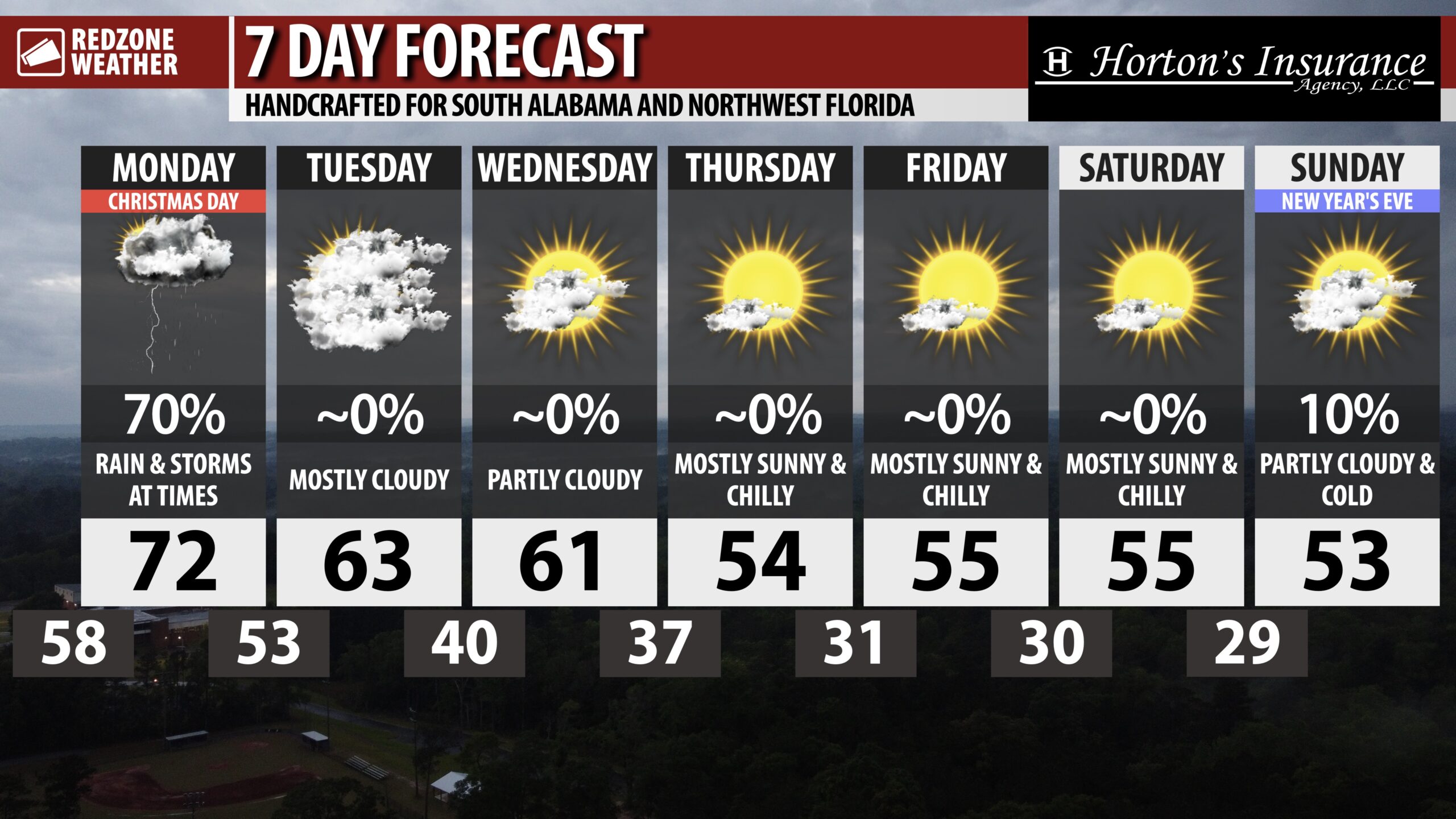
COLD DAYS AND VERY COLD NIGHTS LATER THIS WEEK… Quite a COLD pattern upcoming later this week! High temperatures will be in the 50s with morning lows near or below freezing into the weekend.


RAIN & STORMS MOVE OUT TODAY; MUCH COLDER LATER THIS WEEK… Merry Christmas! I hope you, your family, and friends have a wonderful Christmas Day. Rain and thunderstorms will continue to gradually move to the east and ultimately out of our area by midday. High temperatures will be well above our climatologically average temperatures for Christmas Day. Most spots will peak in the low-70s this afternoon. Looking ahead to later this week and into the New Year, much cooler temperatures are slated to happen. High temperatures will be in the 50s by Thursday with morning lows below freezing for multiple nights going into the weekend.
MAINLY CLOUDY TUESDAY; SUNSHINE RETURNS WEDNESDAY… Skies will continue to be cloudy on Tuesday with high temperatures likely to be in the low-60s. We will have a few more peeks of sunshine around on Wednesday. Dry conditions are expected Tuesday, Wednesday, and into the latter half of the week.
QUITE COLD LATER THIS WEEK… After unseasonably warm temperatures this weekend, we have a significant pattern change set to occur later this week. High temperatures will be in the low-50s on Thursday, Friday, and Saturday with morning lows likely to be below freezing in many communities across the region. This overall pattern will likely persist into New Year’s Eve and New Year’s Day. There is a real chance temperatures will be in the 30s as we ring in 2024 on Sunday night.
APP… If you haven’t already, be sure to download the free RedZone Weather app to keep up with all the latest information on the world of weather in south Alabama and northwest Florida. redzoneweather.com/app is the link for the free download. Once you have the app downloaded to your iOS or Android device, be sure to visit the Alerts tab (lower right corner) and tap the Alert Settings button to customize the alerts you would like to receive straight from me.
See all the details in your Christmas morning RedZone Weather forecast video. Have a great Christmas Day!

RAIN AROUND ON THIS CHRISTMAS MORNING… Merry Christmas! I hope you, your family, and your friends have a wonderful day.
Rain will move out later this morning into the midday hours. We may have a few lingering showers around this afternoon. Drier conditions prevail tonight into Tuesday.


SHOWERS PUSHING EAST… Pockets of heavy rain continue to gradually shift to the east on this Christmas morning. The overall risk of severe weather has been low and appears to now be getting lower as a low level jet (LLJ) moves away from our local area.
Rain will clear out to the east in the next several hours. Thunderstorms will continue to be possible.
At 5AM, scattered rain and storms continue to progress eastward. While weak, transient areas of rotation have been observed in storms near the coast over the last hour, we have not had tornado warnings this morning so far.
The overall severe weather risk continues to be LOW. pic.twitter.com/Chwn4m3x26
— Spinks Megginson (@rzweather) December 25, 2023
The cell near Ono Island, the Flora-Bama, and Perdido Key is showing signs of rotation while pushing inland as of 4:36AM. Gusty winds likely as this cell continues moving north. pic.twitter.com/WkGU3VeGnM
— Spinks Megginson (@rzweather) December 25, 2023

A narrow band of heavy rain extends from Coffeeville southward to Mobile and Dauphin Island. Ahead of the band of rain, small rotating showers are happening.
Several areas of weak, transient rotation over the last hour. So far, no warnings as of 4:25AM. pic.twitter.com/SPQaLY6gBj
— Spinks Megginson (@rzweather) December 25, 2023

SCATTERED SHOWERS STREAMING INLAND… Scattered showers with occasional thunderstorms continue to move into the local area from the Gulf of Mexico. There are transient areas of rotation noted in some of the storms that have happened over the northern Gulf just offshore over the last hour. So far, these storms have weakened while approaching the immediate coastline.
The overall severe weather risk across land areas remains LOW. The risk is not completely zero, but it is low.
More rain and thunderstorms will be possible over the next 6-8 hours.
Scattered showers and storms continue to stream inland across SW Alabama and NW Florida at 3:06AM.
Wind gusts of ~30 mph continue to happen on this Christmas morning.
Scattered storms will continue over the next several hours. Severe weather risk remains LOW. Not zero, but low! pic.twitter.com/1jo73TYR9n
— Spinks Megginson (@rzweather) December 25, 2023

@rzweather @spann @NWSMobile @WEARAllenStrum @michaelwhitewx Shot between 11:15-11:49 pm CST on 12/24 at Pensacola Beach & Pensacola Bayfront Park. The mist you see in the first video is all sand, and there seems to have been some damaged guard rails at the Bayfront park. #FLwx pic.twitter.com/YNs4u8jGmj
— Benjamin Mashburn (Lower AL WX) (@AlFlor1) December 25, 2023
Lightning has increased over northern Mobile Bay over the last few minutes. Heavy pockets of rain continue to move north near Mobile, Daphne, Spanish Fort, Dauphin Island, Barrineau Park, and Walnut Hill as of 2:11AM. pic.twitter.com/lLewBPPvWY
— Spinks Megginson (@rzweather) December 25, 2023
Scattered rain and storms continue to push north across the region at 2AM.
Seeing occasional broad rotation in the small cells near Mobile Bay. pic.twitter.com/lcSGdPG6xd
— Spinks Megginson (@rzweather) December 25, 2023

Scattered showers continue to stream in from the south early on this Christmas morning. At 1:30AM, heavier rain is happening near Mobile, Prichard, Saraland, Monroeville, Fruitdale, Yarbo, and Seminole.
Rotating cell noted about 11 miles SSE of Dauphin Island pushing north. pic.twitter.com/laihA5XWyg
— Spinks Megginson (@rzweather) December 25, 2023


