Isolated showers and storms near the Alabama beaches may produce funnel clouds or brief waterspouts. There is no formal tornado risk today, thankfully. pic.twitter.com/eQbQwnoGuT
— Spinks Megginson (@rzweather) August 29, 2024
Monthly Archives: August 2024
8:25AM August 29, 2024
7:02AM August 29, 2024
6:52AM August 29, 2024
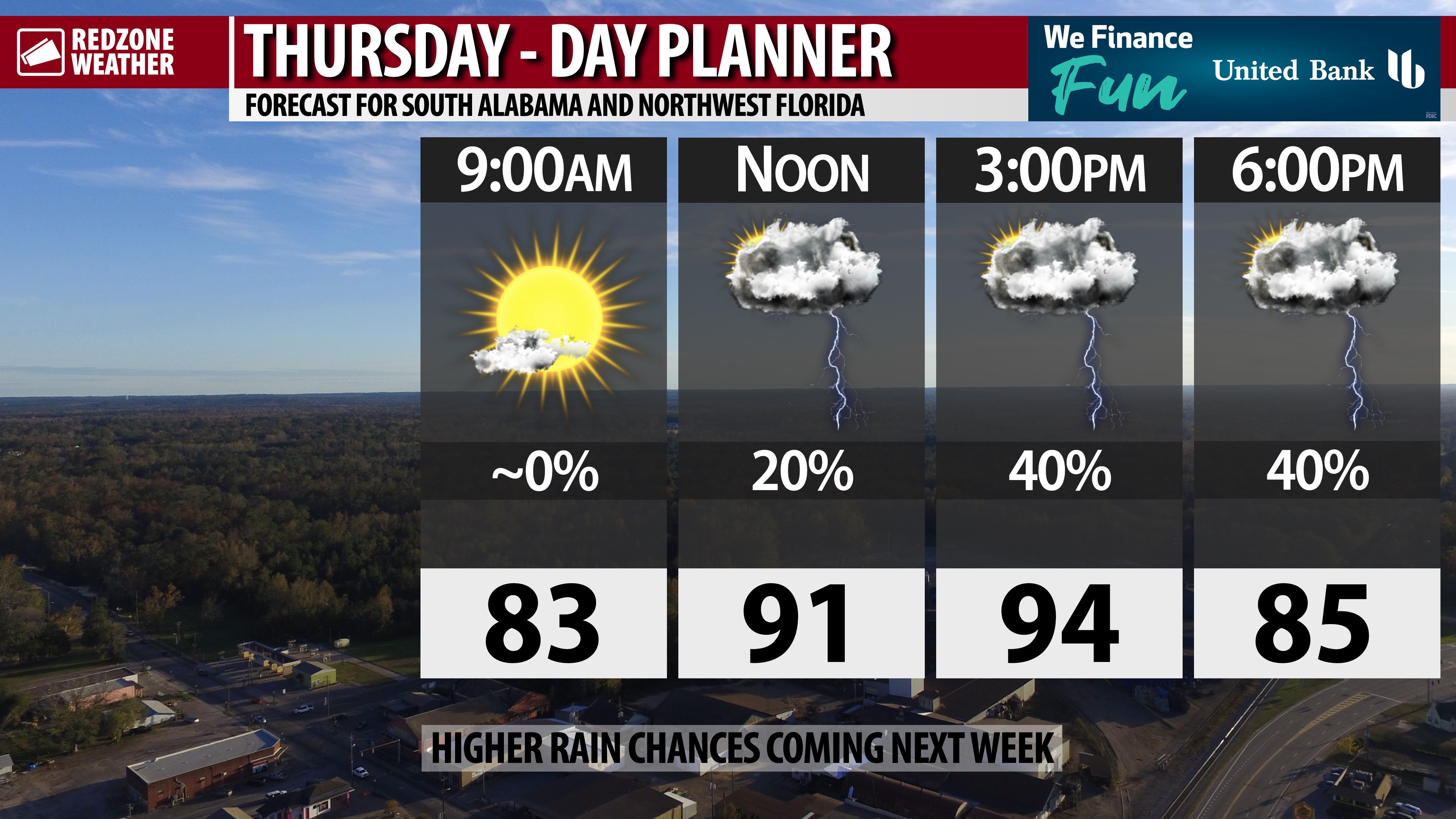
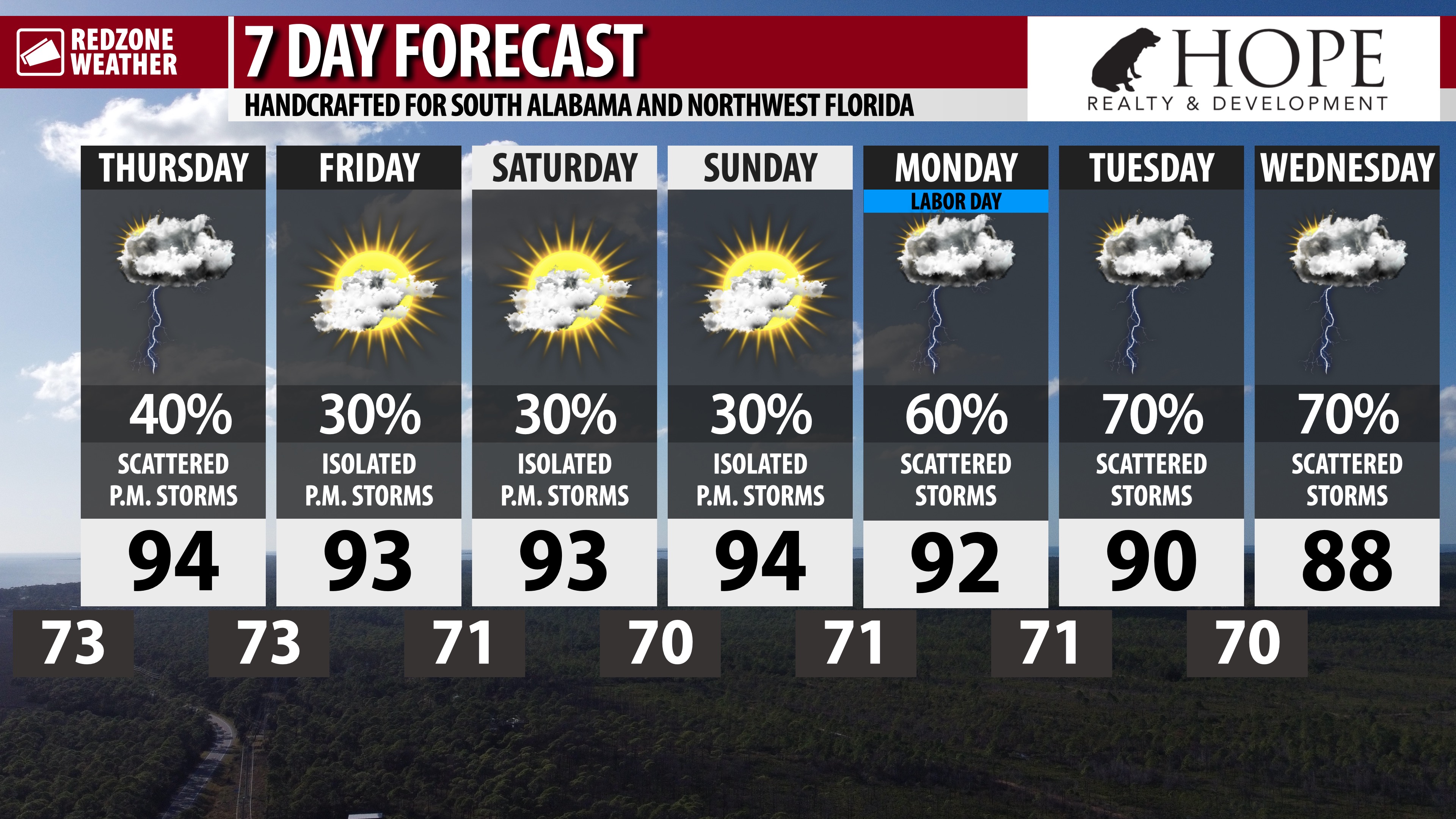
POP-UP STORMS TODAY; HIGHER RAIN CHANCES NEXT WEEK… Scattered thunderstorms will develop this afternoon into this evening across south Alabama and northwest Florida. Storms will probably be more numerous today compared to the last few days. Most of the pop-up thunderstorms will happen in the afternoon and evening hours. Widespread severe weather is not expected, but some of the storms may “pack a punch,” producing cloud-to-ground lightning, loud thunder, and heavy downpours of rain.
TROPICS: TROPICAL WAVE IN ATLANTIC… There is a 20% chance that a tropical wave may become more organized (to the point that it becomes a named tropical storm) as the system nears the Lesser Antilles. From NHC: “An area of disorganized showers over the central tropical Atlantic is associated with a tropical wave. Some slow development of this system is possible this weekend into early next week while it moves westward to west-northwestward at 10 to 15 mph.”
TROPICS: SMALL DISTURBANCE IN NORTH-CENTRAL ATLANTIC… An area of disturbed weather to the southeast of Bermuda is producing a cluster of thunderstorms. This system will never come remotely close to Alabama or northwest Florida. From NHC: “A small area of low pressure located a few hundred miles southeast of Bermuda is producing limited shower and thunderstorm activity well to the northeast of its center. Dry air and strong upper-level winds are expected to prevent development of this system while the low moves generally north-northeastward at about 10 mph during the next day or so.”
TROPICS: GULF & CARIBBEAN REMAIN QUIET, FOR NOW… The Gulf of Mexico and Caribbean Sea remain quiet with no new tropical storms expected to form over the next 5-7 days. The climatological peak of hurricane season is rapidly approaching and will happen on September 11.
APP… If you haven’t already downloaded the RedZone Weather app, now is a great time to do that. redzoneweather.com/app is the link to the free download. Once you have the RZW app installed on your iOS or Android device, be sure to visit the Alerts tab to turn on the specific notifications you’d like to receive. All notifications are handcrafted by me. No automation and we promise not to bug you!
See all the details in your Thursday morning RedZone Weather forecast video. Have a great day!
6:29AM August 29, 2024

P.M. POP-UP STORMS EXPECTED… Scattered showers and thunderstorms will likely develop this afternoon into this evening across south Alabama and northwest Florida. High temperatures will be in the mid-90s today with heat index values in the 103-108° range. Hot, humid day!


