2:58PM September 28, 2025
It is a BEAUTIFUL Sunday afternoon across south Alabama and northwest Florida. Temperatures are peaking in the upper 80s with partly cloudy skies. 🌤️
— Spinks Megginson (@rzweather) September 28, 2025

It is a BEAUTIFUL Sunday afternoon across south Alabama and northwest Florida. Temperatures are peaking in the upper 80s with partly cloudy skies. 🌤️
— Spinks Megginson (@rzweather) September 28, 2025
It’s a sloppy storm at the moment but under the mess of clouds, Tropical Depression 9 has strengthened and is now Tropical Storm Imelda.
Imelda will continue moving north through The Bahamas today before a sharp, right/east turn Monday into Tuesday.
No direct impacts from… pic.twitter.com/iJWmlaVM7G
— Spinks Megginson (@rzweather) September 28, 2025

The news for the U.S. East Coast continues to be positive with Tropical Depression 9 expected to sharply turn right/east tomorrow or Tuesday.
Impacts in the Carolinas would largely be limited. Excellent news!
TD9/Imelda-to-be may be a problem for Bermuda later this week. pic.twitter.com/QlXshPNMRH
— Spinks Megginson (@rzweather) September 28, 2025

🌀 27 Years Ago – Hurricane #Georges made landfall in the early morning hours in south Mississippi on September 28, 1998.
➡️ Did You Know – Georges made landfall SEVEN times in September of 1998!
💻 https://t.co/HcOiaEjdCl pic.twitter.com/toFf0ljtjR
— NWS Mobile (@NWSMobile) September 28, 2025

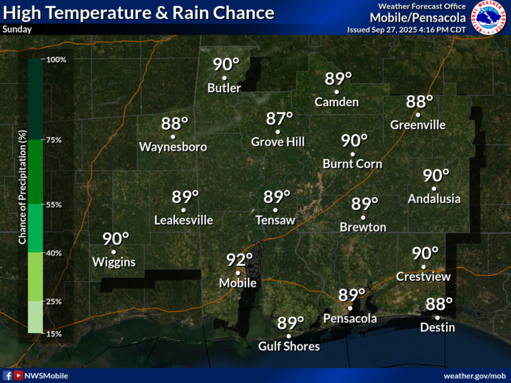
MOSTLY SUNNY, WARM DAY… Skies will remain mostly sunny across south Alabama and northwest Florida on this Sunday. High temperatures are projected to be in the upper 80s and near 90 degrees this afternoon.
Enjoy the day!

New model guidance has caused the National Hurricane Center to shift the projected path for Tropical Depression 9 even further away from the East Coast.
Much better scenario for the Carolinas if this transpires… pic.twitter.com/baxHpCj9tW
— Spinks Megginson (@rzweather) September 28, 2025

Hurricane Humberto remains a category 5 hurricane early on this Sunday. Thankful this storm won’t be directly affecting land areas over the next few days.
Impacts from Humberto possible in Bermuda late Monday into Tuesday. pic.twitter.com/Tee5Stn27R
— Spinks Megginson (@rzweather) September 28, 2025
