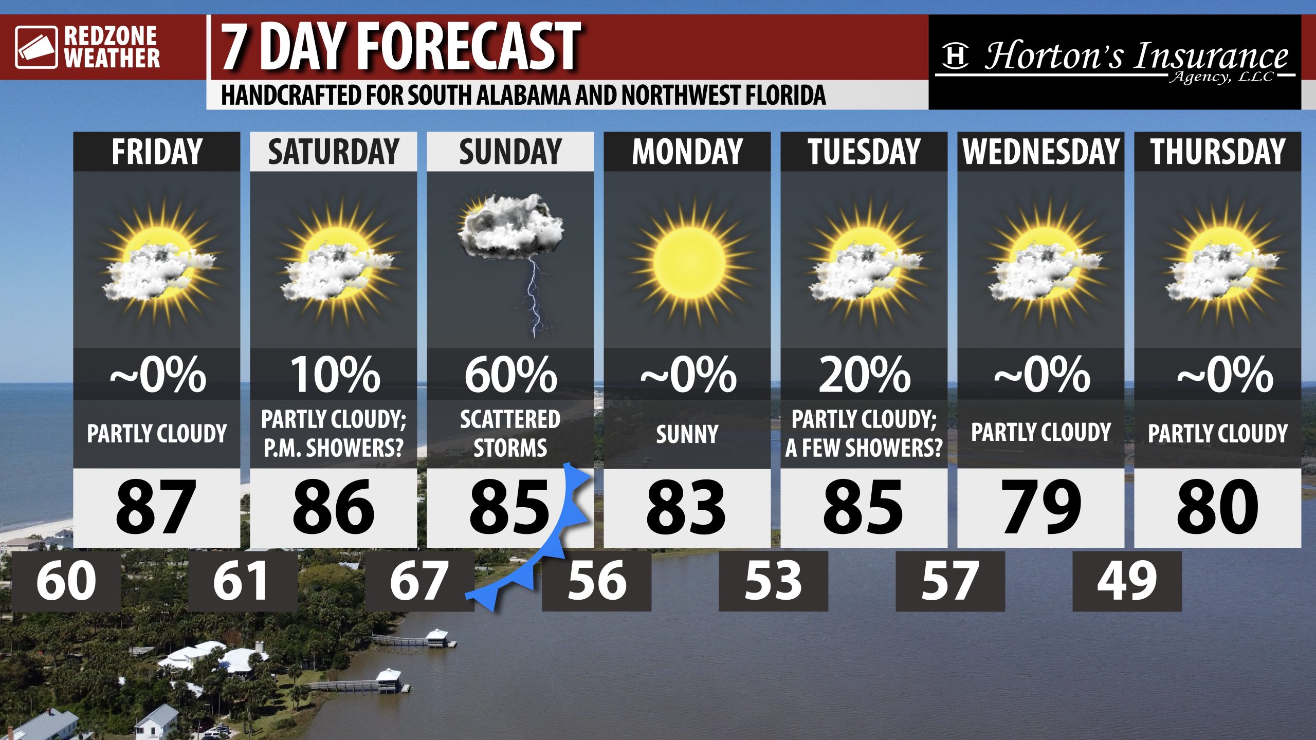
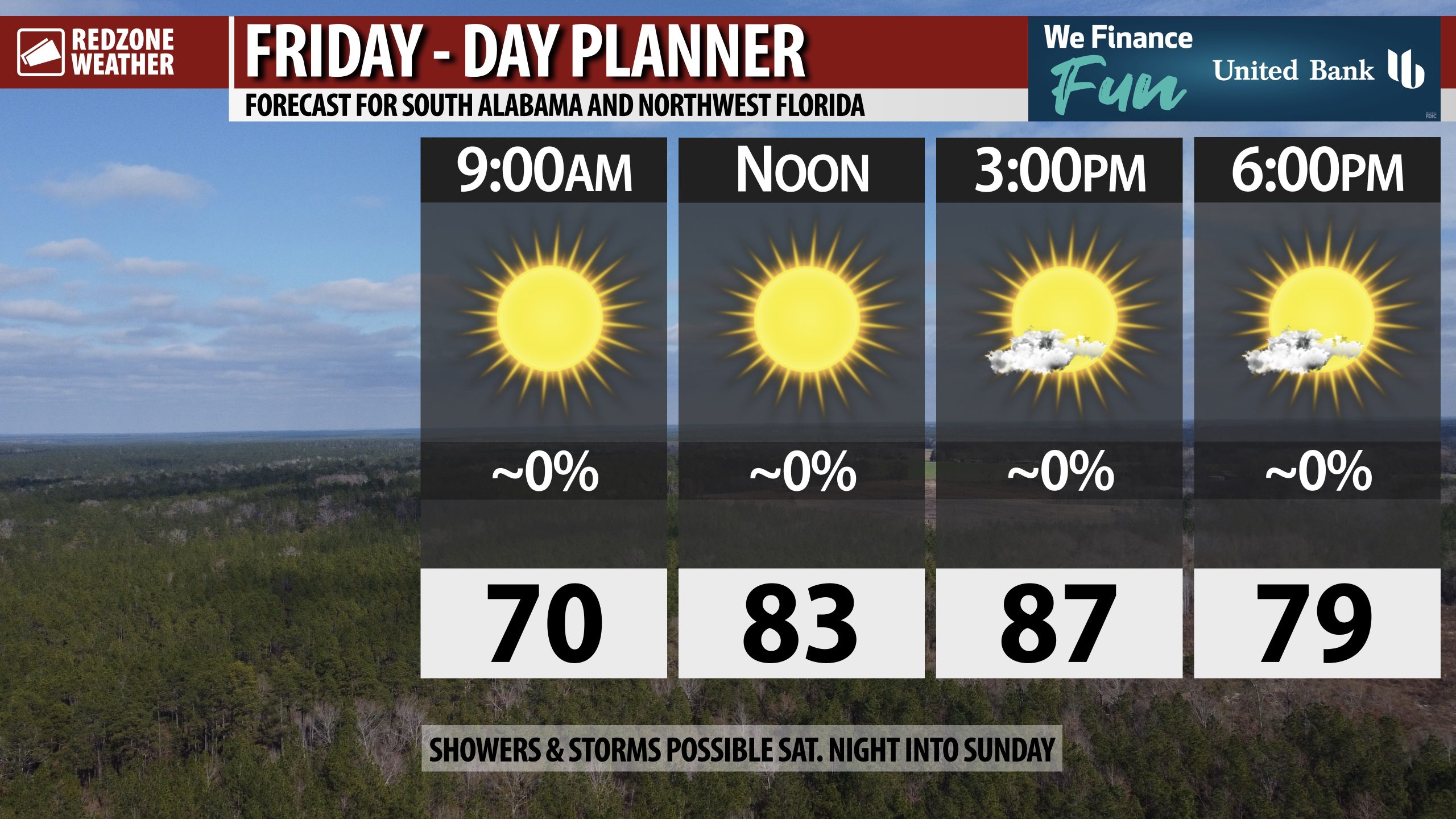
NICE FRIDAY; ISOLATED STORMS SATURDAY NIGHT INTO SUNDAY… Dry weather continues on this Friday ahead of rain being possible across south Alabama and northwest Florida on Saturday night into Sunday. High temperatures today will be in the upper 80s. Temperatures this evening will fall into the 70s. I expect much of the daytime hours of Saturday (if not all) to be dry. Scattered storms will be possible Saturday night into Sunday, but unfortunately not every community will have rain before this frontal boundary moves through. Next week is shaping up to be a nice week overall with cooler temperatures.
SEVERE WEATHER RISK ACROSS PARTS OF ARKANSAS SATURDAY… Our area is not involved in a severe weather risk on Saturday but our friends to the northwest across parts of Arkansas, northwest Mississippi, and western Tennessee are involved in a Level 2 (out of 5) severe weather risk valid for Saturday into Sunday morning. A few tornadoes, damaging wind gusts, and large hail will be possible in those areas.
RAIN & STORMS POSSIBLE SATURDAY NIGHT INTO SUNDAY… Showers and thunderstorms will first be possible across parts of west Alabama in the evening hours on Saturday with scattered storms gradually spreading eastward throughout the night and into Sunday morning. Rain amounts will generally be in the 0.25″ to 0.5″ range in total across the local area. Heavier rain is expected across the northern part of Alabama and into parts of north Mississippi and Tennessee as well.
20-30% CHANCE OF TROPICAL STORM DEVELOPING IN CARIBBEAN NEXT WEEK… The National Hurricane Center flagged an area of concern in the Caribbean Sea that is valid for next week. A tropical wave, currently located in the open waters of the central Atlantic Ocean, will move into the eastern Caribbean Sea around Tuesday or Wednesday. This feature has a 20-30% chance of becoming a named tropical storm next week. Too early to know where the system ultimately ends up. I will be monitoring this system carefully over the next few days.
TROPICS: GULF REMAINS QUIET… No tropical storms are expected to form over the next 5-7 days in the Gulf. The 2025 Atlantic Hurricane Season will officially end on Sunday, November 30.
APP… If you haven’t already downloaded the RedZone Weather app, now is a great time to do that. redzoneweather.com/app is the link to the free download. Once you have the RZW app installed on your iOS or Android device, be sure to visit the Alerts tab to turn on the specific notifications you’d like to receive. All notifications are handcrafted by me. No automation and we promise not to bug you!
See all the details in your Friday morning RedZone Weather forecast video. My next forecast video will be posted by 7:15AM Monday morning. I will have updates posted throughout the weekend, as needed, in the RedZone Weather app.
Have a great weekend!