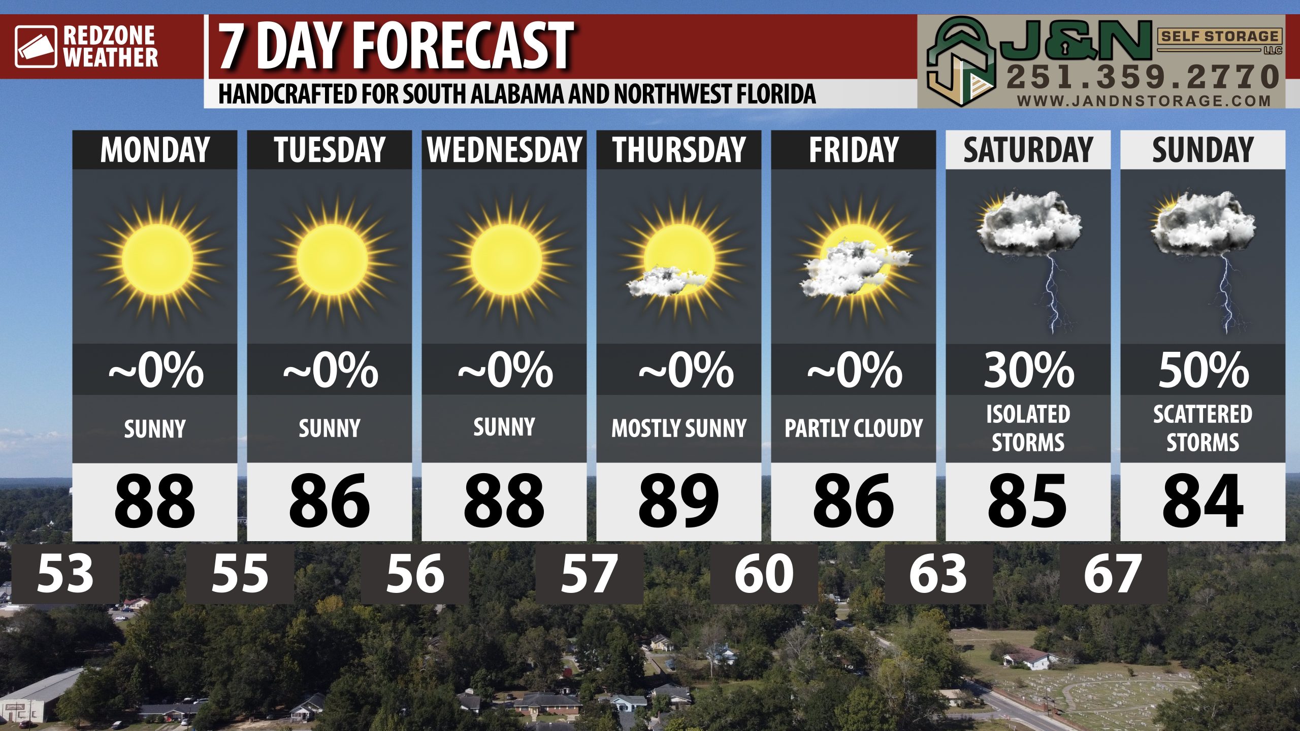
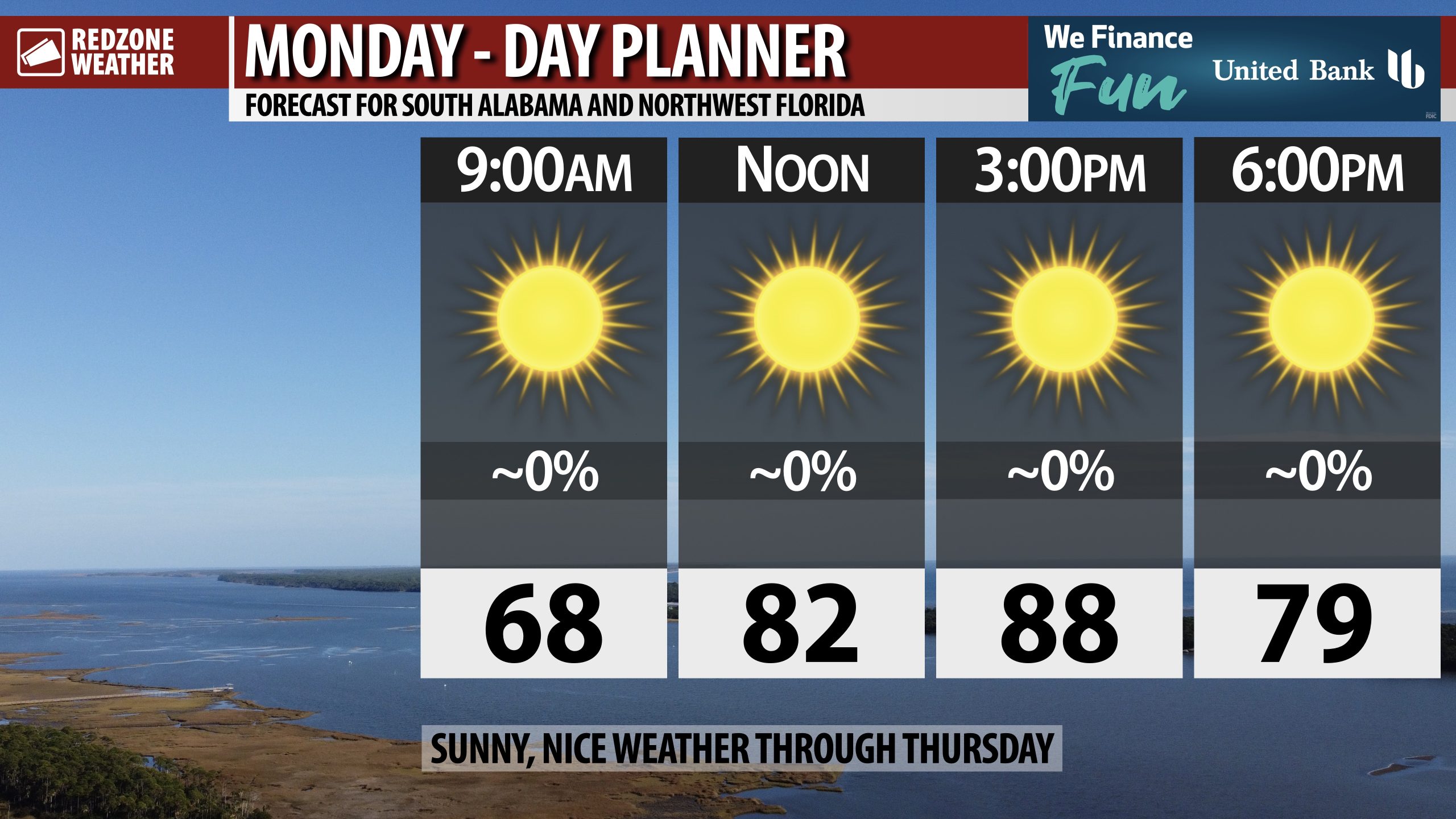
SUNNY SKIES TODAY AND TOMORROW; SCATTERED STORMS POSSIBLE THIS WEEKEND… Sunshine is expected throughout the day on this Monday with high temperatures set to be in mid to upper 80s. Drought conditions will worsen this week, unfortunately, with no rain in the forecast through Friday. Our next real chance of rain happens this weekend as a cold front approaches from the northwest. Scattered showers and thunderstorms will approach the local area on Saturday evening into Sunday. Spotty storms will be possible on Sunday ahead of another dry few days next week.
COOL MORNINGS, WARM DAYS THROUGH FRIDAY… Overnight lows will continue to be in the 50s tonight and again tomorrow night with low 60s likely in the nighttime hours later this week. Afternoon highs will be in the mid to upper 80s each day. Overall, a dry, pleasant weather pattern will be in place this week due to an upper ridge of high pressure in place across the Deep South.
COLD FRONT APPROACHES ON SATURDAY INTO SUNDAY; STRONG STORMS POSSIBLE… Our next chance of rain and thunderstorms will happen on Saturday evening into Sunday as a cold front approaches from the northwest. This system may cause a chance of strong to severe storms across parts of the Deep South. It is too early to know specifics about who may have a chance of severe storms and who won’t. This is certainly something I will be monitoring carefully over the next few days. Please check back in for updates later this week.
TROPICS: GULF & CARIBBEAN QUIET; TROPICAL WAVE IN ATLANTIC… No new tropical storms are expected to form in the Gulf or in the Caribbean Sea over the next 5 days. The National Hurricane Center issued their final advisory on Tropical Storm Jerry over the weekend. Subtropical Storm Karen also formed and dissipated 18 hours later in the far northern Atlantic Ocean, well away from land areas, on Saturday. An area of disturbed weather associated with a tropical wave in the central Atlantic Ocean may become a named tropical storm over the next few days. The system will very likely remain away from land areas through this week.
APP… If you haven’t already downloaded the RedZone Weather app, now is a great time to do that. redzoneweather.com/app is the link to the free download. Once you have the RZW app installed on your iOS or Android device, be sure to visit the Alerts tab to turn on the specific notifications you’d like to receive. All notifications are handcrafted by me. No automation and we promise not to bug you!
See all the details in your Monday morning RedZone Weather forecast video. My next forecast video will be posted by 7:15AM tomorrow morning. I will have updates posted throughout the day, as needed, in the RedZone Weather app.
Hope you have a great start to your week!