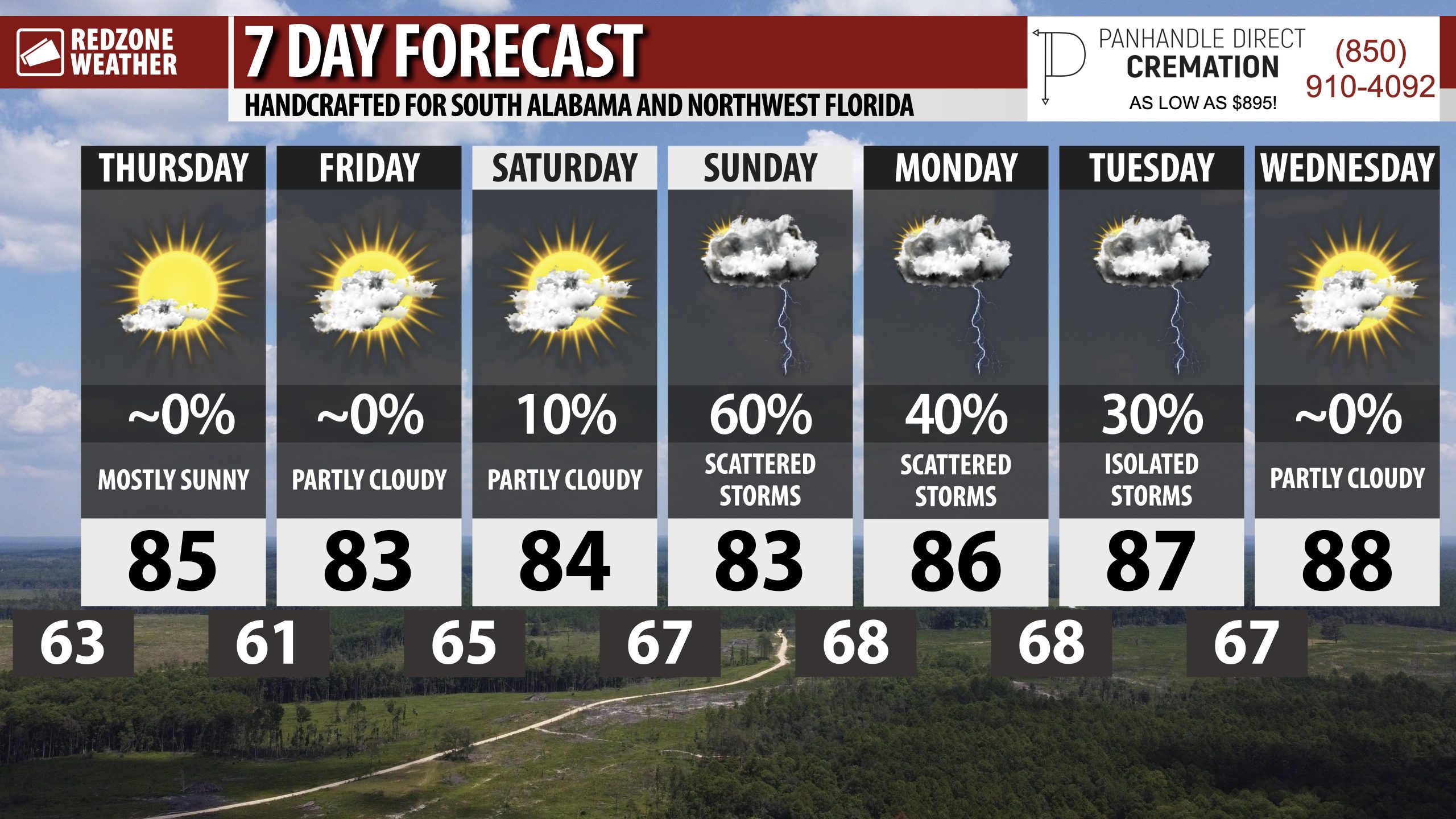
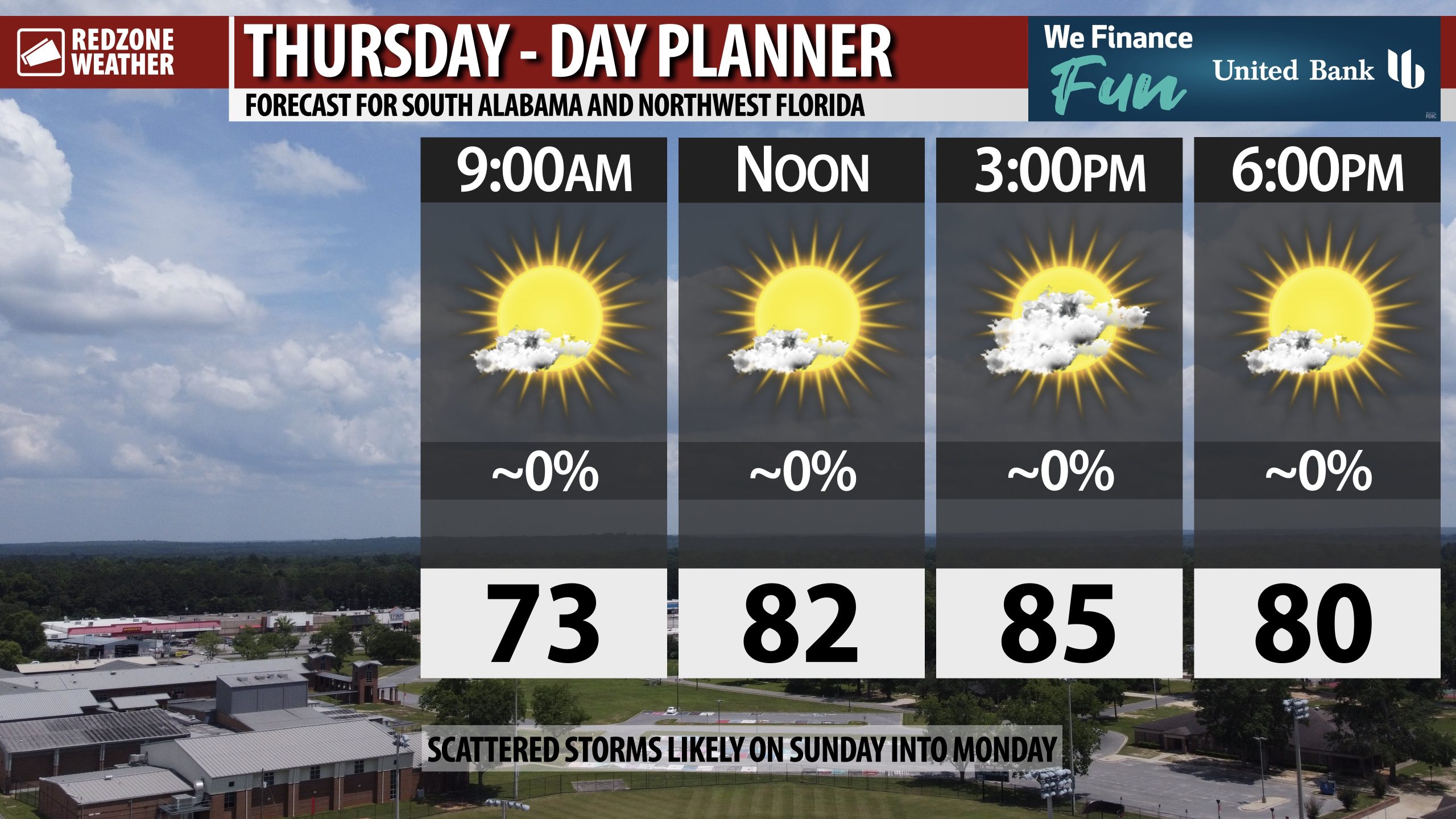
SLIGHTLY COOLER, DRIER AIR TODAY AND TOMORROW; RAIN & STORMS LIKELY SUNDAY… Mostly sunny, nice weather is expected across south Alabama and northwest Florida on this Thursday. High temperatures will be in the mid 80s in most communities across the region. There may be a few passing clouds, particularly this afternoon into this evening, but it will be a mostly sunny day across much of the local area. Tomorrow is slated to be dry and nice with slightly cooler temperatures ahead of increasing rain chances as we get into Sunday and Monday as a weak area of low pressure develops in the northern Gulf and pushes ashore. Thankfully, there is high confidence this system won’t develop into an organized, significant tropical system.
COOLER TEMPS OVERNIGHT; PLEASANT WEATHER ON FRIDAY… Low 60s are expected for overnight lows across much of the region tonight. Communities north of US84, like Thomasville, Beatrice, Camden, Forest Home, Pine Apple, Greenville, and Butler may have lows briefly in the upper 50s by 6AM Friday morning. Pleasant temperatures are expected throughout the day on Friday as well with highs projected to be in the low 80s. Dry conditions are expected today, tonight, and tomorrow.
FEW SHOWERS POSSIBLE SATURDAY EVENING NEAR COAST… Much of the day on Saturday should be dry across the region with high temperatures in the 80s. A few widely scattered showers and thunderstorms may become possible, specifically near the Alabama and northwest Florida beaches, on Saturday evening into Saturday night. Widespread severe storms are not expected, but don’t be caught off guard, especially if you’re right at the beaches Saturday evening, by a few showers.
RAIN & STORMS LIKELY AT TIMES SUNDAY INTO MONDAY… Scattered showers and thunderstorms will be possible throughout the day on Sunday into Sunday night and Monday. It will NOT rain all day Sunday or Monday, but we will have intermittent showers and thunderstorms around due to an area of low pressure expected to form in the northern Gulf and gradually push onshore into Monday. Widespread severe storms are unlikely, but there may be just enough instability and shear to cause a few waterspouts in the northern Gulf as this system moves onshore.
TROPICS: HURRICANE IMELDA MOVING NORTHEAST; FINAL ADVISORY ON HUMBERTO… Hurricane Imelda continues to accelerate to the northeast in the Atlantic Ocean near Bermuda this morning. Imelda is expected to rapidly become extratropical later today or tonight. The National Hurricane Center issued their final advisory on the system that once was Hurricane Humberto yesterday. The remnants of Humberto have been absorbed by a frontal boundary that ultimately will merge in with Imelda as well.
APP… If you haven’t already downloaded the RedZone Weather app, now is a great time to do that. redzoneweather.com/app is the link to the free download. Once you have the RZW app installed on your iOS or Android device, be sure to visit the Alerts tab to turn on the specific notifications you’d like to receive. All notifications are handcrafted by me. No automation and we promise not to bug you!
See all the details in your Thursday morning RedZone Weather forecast video. My next forecast video will be posted by 7:15AM tomorrow morning. I will have updates posted throughout the day, as needed, in the RedZone Weather app.
Have a nice Thursday!