1:14PM December 19, 2025
Extremely rare Tornado Warning was issued about an hour ago for parts of Hawaii… https://t.co/pmD5gJtGBx
— Spinks Megginson (@rzweather) December 19, 2025

Extremely rare Tornado Warning was issued about an hour ago for parts of Hawaii… https://t.co/pmD5gJtGBx
— Spinks Megginson (@rzweather) December 19, 2025
NAS Whiting Field @NASWF is partnering with Santa Claus to give him a preview of his route across Santa Rosa and Escambia (FL) counties.
Want to see Santa? Look up if you’re near Pensacola Beach, Pensacola, Pace, and Milton on MONDAY around midday. 🎅🏻 pic.twitter.com/sNnTQZH3hG
— Spinks Megginson (@rzweather) December 19, 2025

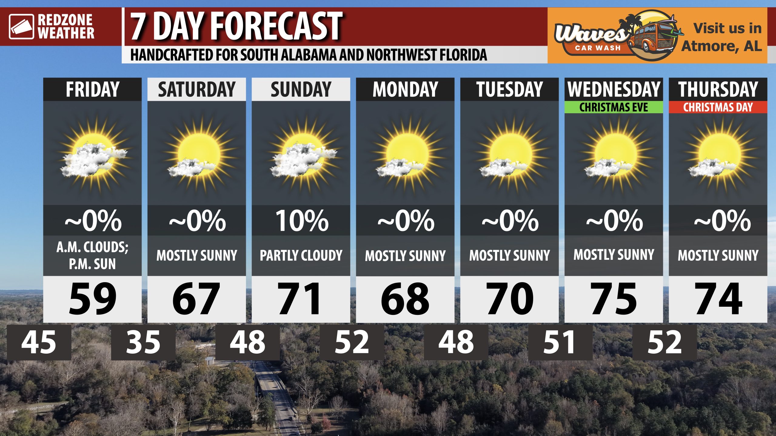
COLD TODAY AND TONIGHT; WARMER NEXT WEEK… If you’re a cold weather fan, enjoy today and tonight as the next 7 days look increasingly warmer, particularly when compared with the first half of December.
Christmas Eve and Christmas Day will both have high temperatures in the 70s!

COOL TODAY & COLD TONIGHT; MILD DAYS, COOL NIGHTS FOR CHRISTMAS WEEK… If you’re a cold weather fan, you’d better enjoy today and tonight as the next 7-10 days after today look increasingly warm. Temperatures will be running 10 to 15 degrees above our climatological averages for this time of year as we get toward the middle and latter part of the upcoming week, aka just in time for Christmas. I know many folks want a chilly weather pattern on Christmas Day, but that simply is not in the cards for south Alabama and northwest Florida this year. High temperatures will be in the upper 60s and low 70s starting tomorrow. Overnight lows will be in the 40s and 50s next week.
DRY PATTERN OVERALL AFTER SUNDAY… Our next chance of rain happens on Sunday when a few widely scattered showers may be possible across the region. No rain is expected from Monday through Friday of the upcoming week, meaning Christmas will be dry across the region.
NORMAL TO HAVE WILDLY VARYING TEMPERATURES THIS TIME OF YEAR… The winter months have the biggest temperature swings across our part of the world. Sometimes you can temperatures as low as the single digits but other times, temperatures can be as warm as 80° or 85°. The last few Christmases across south Alabama and northwest Florida have varied quite a bit (as expected). The average high for Christmas Day is 63° and the average low is 43°.
Christmas 2025 is projected to have a high of 74° with a low of 52° (above normal)
Christmas 2024 had a high of 64° and a low of 47° (near normal)
Christmas 2023 had a high of 74° and a low of 50° (above normal)
Christmas 2022 had a high of 48° and a low of 26° (significantly below normal)
Christmas 2021 had a high of 77° and a low of 57° (significantly above normal)
Christmas 2020 had a high of 51° and a low of 29° (significantly below normal)
APP… If you haven’t already downloaded the RedZone Weather app, now is a great time to do that. redzoneweather.com/app is the link to the free download. Once you have the RZW app installed on your iOS or Android device, be sure to visit the Alerts tab to turn on the specific notifications you’d like to receive. All notifications are handcrafted by me. No automation and we promise not to bug you!
See all the details in your Friday morning RedZone Weather forecast video. My next forecast video will be posted by 7:15AM Monday morning. I will have updates posted throughout the weekend, as needed, in the RedZone Weather app.
Have a great weekend!

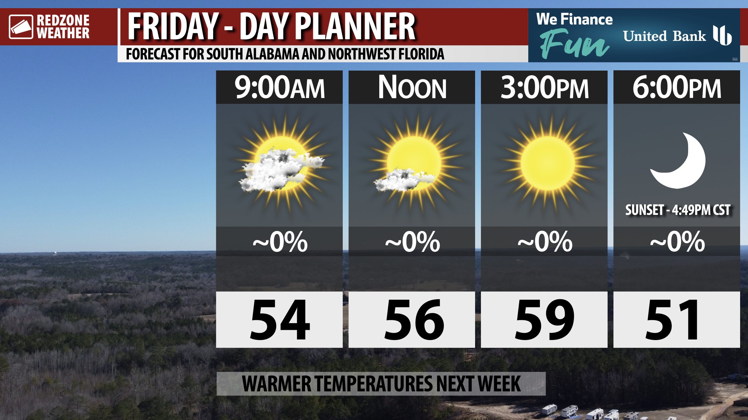
SUNSHINE RETURNS TODAY; WARM TEMPS COMING NEXT WEEK… Clouds clear out to the east, meaning sunny skies are slated to return on this Friday. Today will be the coldest day in the next 7 days with highs only in the upper 50s.
Tonight will be our last cold night for awhile. Overnight lows by 6AM Saturday will be in the 30s.
Warmer temperatures are on the way for next week!

Spotty showers and perhaps a thunderstorm or two will be possible over the next few hours as a cold front moves across south Alabama and northwest Florida.
Not expecting any severe weather issues locally. pic.twitter.com/zxsr3xEtWd
— Spinks Megginson (@rzweather) December 19, 2025

This final band of showers for the evening is struggling to maintain any intensity at all as it pushes east across southwest Alabama.
A few showers are happening near Monroeville, Mexia, Beatrice, Tunnel Springs, Goodway, Excel, Stockton, and Axis. pic.twitter.com/vCMCDJPYfb
— Spinks Megginson (@rzweather) December 19, 2025
