11:32PM February 13, 2026
RT @dittogorme: Crewe of Columbus Mobile,AL @spann @NWSMobile @rzweather @ThomasGeboyWX @textamet @VisitMobileAL @AlanSealls #MardiGras2026…
— Spinks Megginson (@rzweather) February 14, 2026

RT @dittogorme: Crewe of Columbus Mobile,AL @spann @NWSMobile @rzweather @ThomasGeboyWX @textamet @VisitMobileAL @AlanSealls #MardiGras2026…
— Spinks Megginson (@rzweather) February 14, 2026
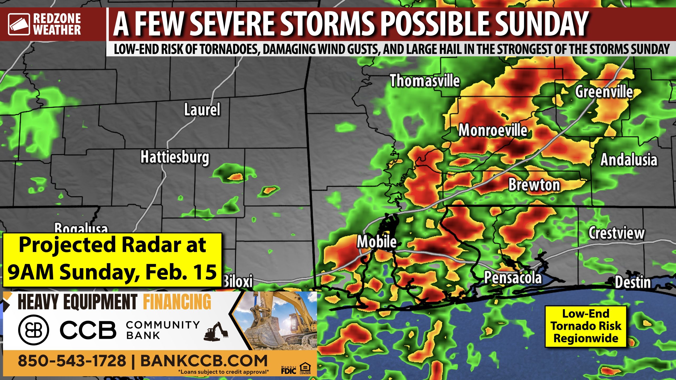
ISOLATED SEVERE STORMS POSSIBLE SUNDAY; WINDY SAT. NIGHT INTO SUNDAY… Multiple waves of scattered showers and thunderstorms will be possible on Sunday, February 15. The Storm Prediction Center has included all of south Alabama, northwest Florida, southeast Mississippi, southwest Georgia, and much of the Florida Panhandle region in their low-end, Level 1 (out of 5) severe weather risk starting Sunday morning and extending through the evening hours. The first round of storms will happen early Sunday morning, perhaps starting before sunrise across parts of west Alabama. The second round of storms (IF it materializes) may have more of a tornado risk. In addition to the severe weather risk, gusty winds
SEVERE WEATHER TIMING – SUNDAY… 5AM to 7PM Sunday is the window for isolated severe storms developing across south Alabama and northwest Florida. Two distinct rounds of thunderstorms will be possible. The first round will set up from 5AM to Noon. This round will be more likely to produce damaging straight line wind gusts and perhaps a brief tornado or two. The second round of storms is more conditional, meaning there is a chance the second round may not materialize. The second round will happen from 2PM to 7PM IF it materializes. Large hail and tornadoes would be the concerns in Round 2 of 2.
BREEZY CONDITIONS SUNDAY… Windy conditions are expected outside of the thunderstorms, starting Saturday night and existing throughout the day on Sunday and into Sunday evening. Winds will subside Monday in the early morning hours.
SPECIFIC HAZARD EXPLANATION… The risk of damaging wind gusts and a few tornadoes will happen on Sunday morning. This is because the expectation is for a squall line of thunderstorms to be moving from west to east across the region. Gusty winds will be capable of knocking down trees. A few spin-up tornadoes are not out of the question. The evening round of storms is expected to be much more scattered in nature. This mode of storms would be more supportive of tornadoes and large hail. Storms will come to an end Sunday evening as we lose daytime heating.
VALENTINE’S DAY FORECAST… If you have outdoor plans for tomorrow (Saturday – Valentine’s Day), conditions are expected to be dry and mild. High temperatures will peak in the 70s. Showers will become possible Saturday evening, likely after 10PM in most communities.
WARM TEMPERATURES TO PERSIST INTO NEXT WEEK… Despite a cold front pushing through on Sunday evening, mild temperatures are here to stay into next week. Afternoon highs will be in the 70s early next week with temperatures near 80° likely by Thursday and Friday. Overnight lows will be in the 40s on Monday night into Tuesday but 50s and 60s are likely for the remainder of the week.
TORNADO WARNING POLICY… Any time there is an active tornado warning in effect for southwest Alabama or northwest Florida, we provide uninterrupted, live video coverage on Facebook Live and YouTube Live. Our detailed coverage commitment is outlined at redzoneweather.com/coverage. We are proud to cover all parts of Escambia (AL), Covington, Monroe, Conecuh, Baldwin, Mobile, Clarke, Washington (AL), Butler, Escambia (FL), Santa Rosa, and Okaloosa counties. If you live in any locale in those counties, be sure to tune into our coverage whenever there is an active tornado warning!
APP ALERTS… redzoneweather.com/app is the link where you can download the free RedZone Weather app. We post brief updates throughout each day in the app, keeping you up-to-date about the latest happenings in weather across south Alabama and northwest Florida. Once you have the free app downloaded to your iOS or Android device, be sure to visit the Alerts tab (lower right corner) then tap the large Alert Settings button to customize the alerts you would like to receive straight from me.
NEXT UPDATES… I will have more updates posted throughout the weekend, as needed, in the RedZone Weather app. My next detailed video update will be posted by 7:15AM tomorrow (Friday) morning with the latest information.
Have a nice Friday evening!

RT @PettusWX: One factor I don’t think is being talked about enough with this upcoming setup is trees already being damaged and are now sub…
— Spinks Megginson (@rzweather) February 14, 2026

Isolated severe storms will be possible on Sunday.
Round 1 happens in the morning hours. Gusty winds and brief tornadoes are the concerns.
Round 2 (of 2) happens in the evening hours. A few tornadoes and hail are the concerns.
Please be able to hear warnings Sunday! https://t.co/3xPSS1tNQx
— Spinks Megginson (@rzweather) February 14, 2026

RT @NWSMobile: A Dense Fog Advisory is in effect for Mobile Bay and Mississippi Sound late tonight into early Saturday morning. Slow down,…
— Spinks Megginson (@rzweather) February 13, 2026

Pleasant weather continues across south Alabama and northwest Florida on this Friday afternoon. Temperatures are in the low 70s across the region.
Rain and storms become possible Saturday night into Sunday. Low-end severe weather risk will set up on Sunday. https://t.co/iLPnbqPFwd
— Spinks Megginson (@rzweather) February 13, 2026

The Storm Prediction Center has included all of south Alabama and northwest Florida in the Level 1 (out of 5) severe weather risk zone valid for Sunday. Gusty winds and hail are the main concerns in the stronger storms that develop. A tornado or two may also be possible. pic.twitter.com/23j1LMGuqo
— Spinks Megginson (@rzweather) February 13, 2026
