10:18AM January 25, 2026
Very windy in Bratt, FL @rzweather pic.twitter.com/DhxpPmYY4E
— Allyson Bell (@AllysonBell17) January 25, 2026

Very windy in Bratt, FL @rzweather pic.twitter.com/DhxpPmYY4E
— Allyson Bell (@AllysonBell17) January 25, 2026
80% chance a Tornado Watch is issued in the next hour or two for parts of south Alabama, northwest Florida, part of the Florida Panhandle region, and southwest Georgia.
The environment is becoming more conducive for tornado development. pic.twitter.com/ruLmDSzOkl
— Spinks Megginson (@rzweather) January 25, 2026

Here’s the main line of storms for today. It has developed across parts of Clarke, Washington, and Choctaw counties in west Alabama.
Once the line of storms passes through your location, you’re done with any risk of severe storms.
Gusty winds possible shortly near Thomasville,… pic.twitter.com/4bWFa9RnrB
— Spinks Megginson (@rzweather) January 25, 2026

Thunderstorms will likely be strengthening while crossing our local area from west to east. Here is the HRRR projected radar loop… pic.twitter.com/5JbQ32iQgo
— Spinks Megginson (@rzweather) January 25, 2026

Showers are increasing in coverage across west Alabama. Storms are developing across parts of southeast Mississippi.
Severe weather risk likely to ramp up a bit later this morning. pic.twitter.com/tHEyST8hg4
— Spinks Megginson (@rzweather) January 25, 2026

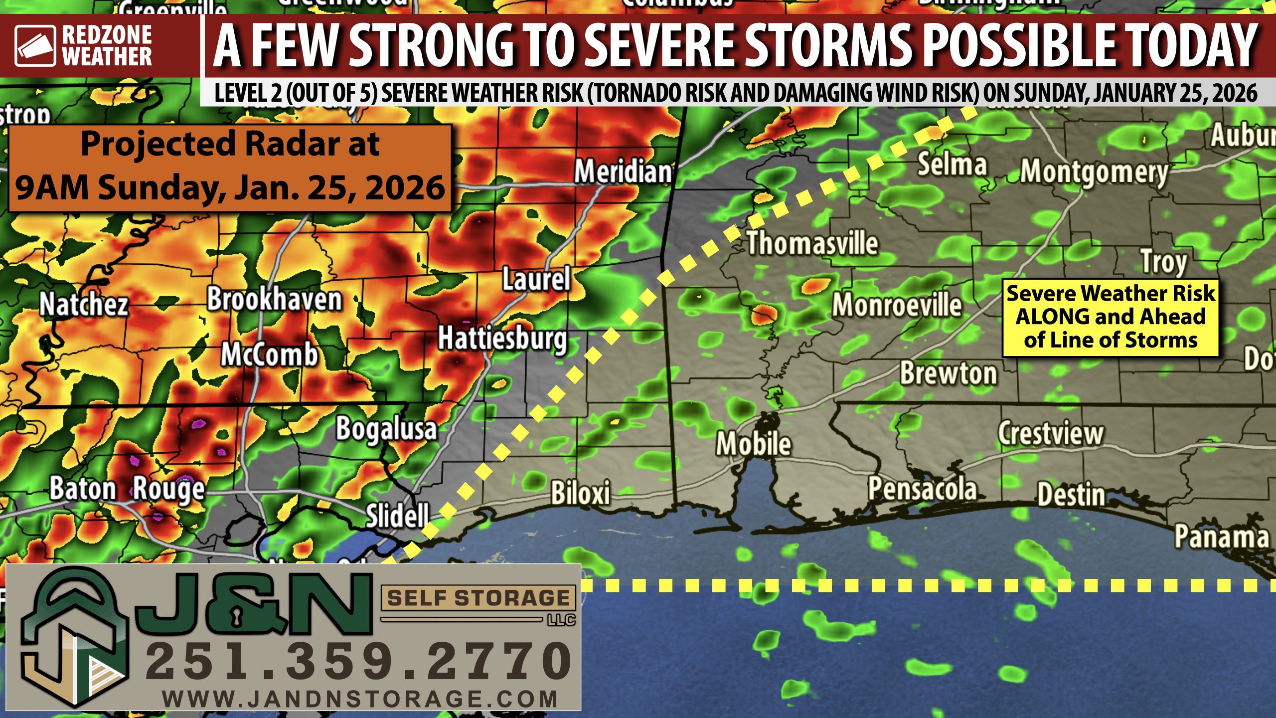
RAIN & STORMS LIKELY LATER TODAY; A FEW STORMS MAY BE SEVERE… Thunderstorms are likely later today ahead of a strong cold front that will quickly bring down temperatures across south Alabama and northwest Florida. Timing has changed a bit. It looks like storms will cross our region from 9AM to 3PM with storms exiting to the east by 4-5PM at the latest. That is a bit earlier than previously suggested. Strong to severe thunderstorms capable of producing tornadoes and damaging wind gusts will be possible. The greatest potential for severe storms will be in areas along, south, and east of I-65 today where a slightly more conducive environment exists for severe storm development. Outside of the storms, a Wind Advisory is in place for the entire local area as 30 to 40 mph wind gusts will be possible ahead of the storms. Much colder air arrives tonight. An Extreme Cold Warning is now in effect for the entire region for the overnight hours into Monday morning.
SEVERE WEATHER TIMING – TODAY… 9AM to 5PM is now the window for strong to severe storms across south Alabama and northwest Florida with the core window being from 11AM to 3PM. We encourage everyone to have multiple ways to hear warnings today, just in case a tornado warning is needed for your specific location.
WIND ADVISORY FOR ENTIRE LOCAL AREA… Long before storms begin, breezy conditions and wind gusts as high as 30 to 40 mph will be possible across the region. A Wind Advisory is in effect until 3PM this afternoon.
EXTREME COLD WARNING – TONIGHT… The National Weather Service has a rare Extreme Cold Warning in place for ALL local counties across south Alabama and northwest Florida valid from midnight tonight to Noon on Monday. Dangerously low wind chills as low as 10 degrees will be possible tonight into Monday morning. Air temperatures will be in the 10s in many communities by 6AM Monday.
BLACK ICE LESS LIKELY LOCALLY… Due to storms moving through earlier, it looks like the back edge of the rain will likely move to the east of southwest Alabama and northwest Florida this afternoon into the early evening hours. This means that at least 4-6 hours of drying time should exist between when rain/storms depart and when freezing temperatures happen. The cold, dry air will filter in with the blustery conditions behind the advancing cold front. This should help to mitigate the overall potential of black ice across much of the region this evening into tonight. Patchy areas of black ice may be possible in highly isolated areas tomorrow morning, but I do not expect this to be the norm.
NEXT WEEKEND MORE LIKELY TO BE SUNNY & QUIET… Model support for a snow/winter storm event NEXT weekend has collapsed, meaning all of the major global models are now showing sunny, dry weather for the local area. While it is far too early to rule out snow, for sure, it appears model support for a sunny, quiet pattern appears to be increasing. Models basically show the area of low pressure developing about 500 miles to our south and remaining far enough south in the Gulf that no precipitation would happen locally. This is something that will need to be monitored over the next few days as changes will be possible. I would question any “source” that has promoted a snow potential 7-10 days out – a totally irresponsible and unwise thing to do considering it is nearly impossible to forecast snow in the Deep South 3-4 days out, let alone 7-10 days.
TORNADO WARNING POLICY… Any time there is an active tornado warning in effect for southwest Alabama or northwest Florida, we provide uninterrupted, live video coverage on Facebook Live and YouTube Live. Our detailed coverage commitment is outlined at redzoneweather.com/coverage. We are proud to cover all parts of Escambia (AL), Covington, Monroe, Conecuh, Baldwin, Mobile, Clarke, Washington (AL), Butler, Escambia (FL), Santa Rosa, and Okaloosa counties. If you live in any locale in those counties, be sure to tune into our coverage whenever there is an active tornado warning!
APP ALERTS… redzoneweather.com/app is the link where you can download the free RedZone Weather app. We post brief updates throughout each day in the app, keeping you up-to-date about the latest happenings in weather across south Alabama and northwest Florida. Once you have the free app downloaded to your iOS or Android device, be sure to visit the Alerts tab (lower right corner) then tap the large Alert Settings button to customize the alerts you would like to receive straight from me.
I will have updates posted in the hours ahead in the RedZone Weather app. Join me there, even when we are not in live video coverage, for updates.
Have a great Sunday!

There was some concern for an isolated supercell to develop around 5-6AM across parts of our local area. That did not happen. Radar is quiet as of 6AM. A few showers are happening near Navarre, Woodlawn Beach, and Grove Hill.
Rain coverage increases in the hours ahead. pic.twitter.com/sHqFWiHdBj
— Spinks Megginson (@rzweather) January 25, 2026
