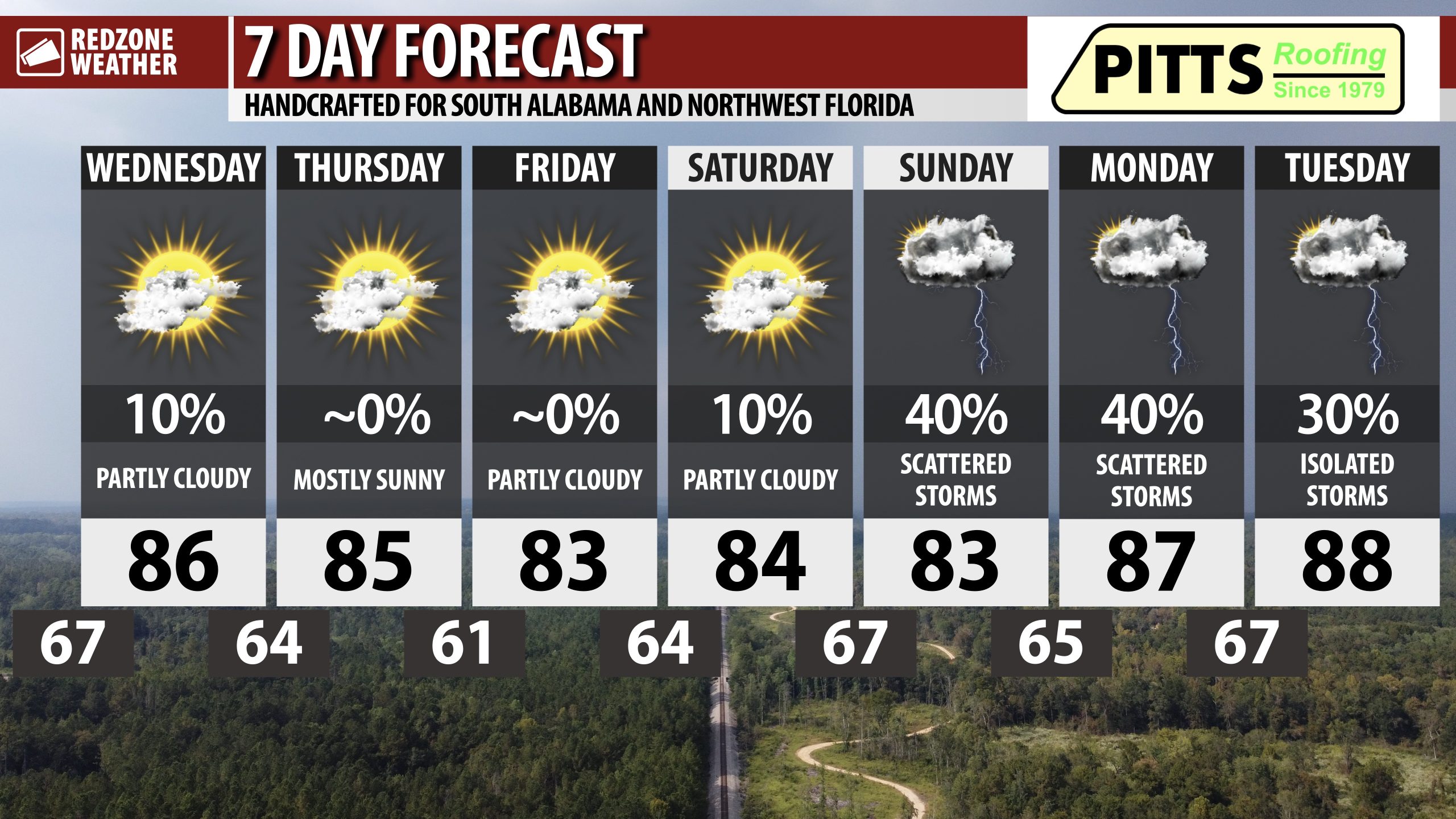
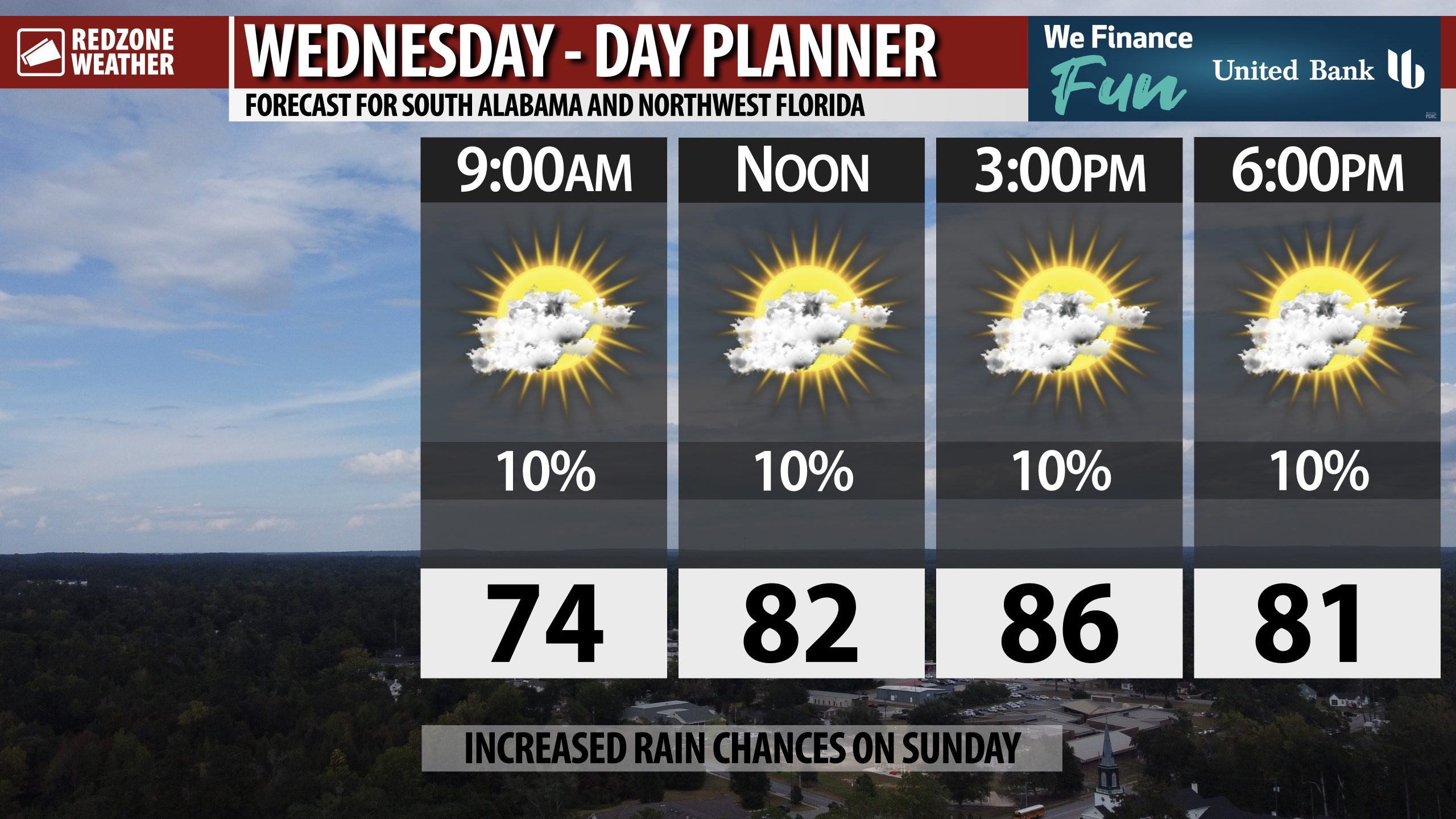
PLEASANT EARLY FALL WEATHER TODAY AND TOMORROW; RAIN RETURNS SUNDAY INTO MONDAY… Rain chances are quite low today, not entirely zero, but quite low. There may be a few highly isolated sprinkles and showers around, specifically between 4PM and 8PM, but most communities across the region should remain dry. Temperatures will be comfortable for early fall with most spots having highs in the mid 80s. We have slightly cooler air set to move in on Friday morning ahead of higher rain chances in the latter half of the weekend into early next week.
NICE TEMPERATURES OVER THE NEXT FEW DAYS… If you’ve stepped outside this morning, you probably noticed the air feeling a bit drier and more pleasant than the last few days. That will be the trend over the next few days with slightly less humid air in place across much of the Deep South. High temperatures will be in the mid 80s today and tomorrow ahead of highs in the low 80s on Friday. Overnight lows on Thursday night into Friday morning will be in the low 60s in many communities across south Alabama and northwest Florida. Some spots north of US84 may dip into the upper 50s briefly on Friday morning.
SHOWERS RETURN THIS WEEKEND INTO EARLY NEXT WEEK… A weak, tropical area of low pressure will likely move north from the northern Gulf into our region on Sunday into Monday. This feature will cause rain chances to rise across the local area on Sunday and on Monday. It won’t be an “all day washout” either day but we will probably have scattered showers around at times. The greatest rain amounts will likely happen closer to the Alabama and northwest Florida beaches. For now, widespread severe weather seems unlikely.
TROPICS: GULF LOW MAY DEVELOP, CARIBBEAN QUIET… There is no imminent threat of a tropical storm developing in the Gulf or Caribbean today or tomorrow. Some of the weather models indicated the potential for an area of low pressure to develop in the northern Gulf and push ashore in our local area early next week, but the system will probably remain too weak to be anything of substance. Most likely, our area will simply have higher rain chances Sunday, Monday, and perhaps into Tuesday morning.
TROPICS: IMELDA AND HUMBERTO IN THE ATLANTIC… Hurricane Imelda and Hurricane Humberto continue to move away from the continental United States in the northern Atlantic Ocean. Imelda will bring significant impacts to Bermuda over the next 12-24 hours. A Hurricane Warning continues for Bermuda.
APP… If you haven’t already downloaded the RedZone Weather app, now is a great time to do that. redzoneweather.com/app is the link to the free download. Once you have the RZW app installed on your iOS or Android device, be sure to visit the Alerts tab to turn on the specific notifications you’d like to receive. All notifications are handcrafted by me. No automation and we promise not to bug you!
See all the details in your Wednesday morning RedZone Weather forecast video. My next forecast video will be posted by 7:15AM tomorrow morning. I will have updates posted throughout the day, as needed, in the RedZone Weather app.
Have a good Wednesday!