5:11PM January 6, 2026
Beautiful sky color near Brewton Middle School in Brewton, AL. Thanks to Melissa McMillan with Hope Realty & Development for the view! pic.twitter.com/44iu67Ws2W
— Spinks Megginson (@rzweather) January 6, 2026

Beautiful sky color near Brewton Middle School in Brewton, AL. Thanks to Melissa McMillan with Hope Realty & Development for the view! pic.twitter.com/44iu67Ws2W
— Spinks Megginson (@rzweather) January 6, 2026
Sunset in Brewton, Alabama tonight @rzweather pic.twitter.com/gCdN6kbLIU
— Sean McAllister (@nwfltracking) January 6, 2026

Great afternoon with the 2nd Grade classes at Bagdad Elementary School in Bagdad, FL.
Wonderful group! Thanks to Mrs. Currie for the invite! pic.twitter.com/KMt1rTGbSV
— Spinks Megginson (@rzweather) January 6, 2026

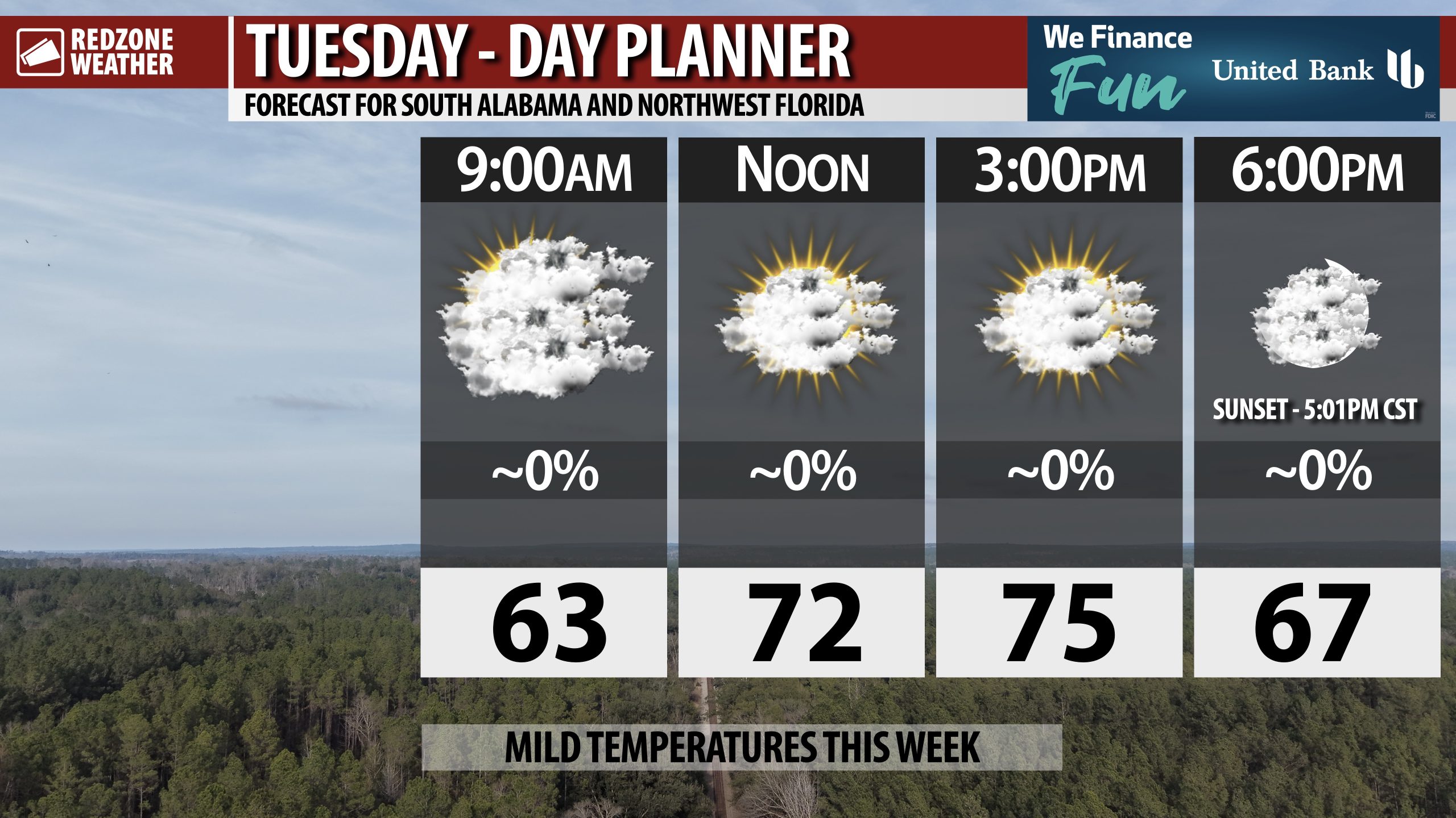
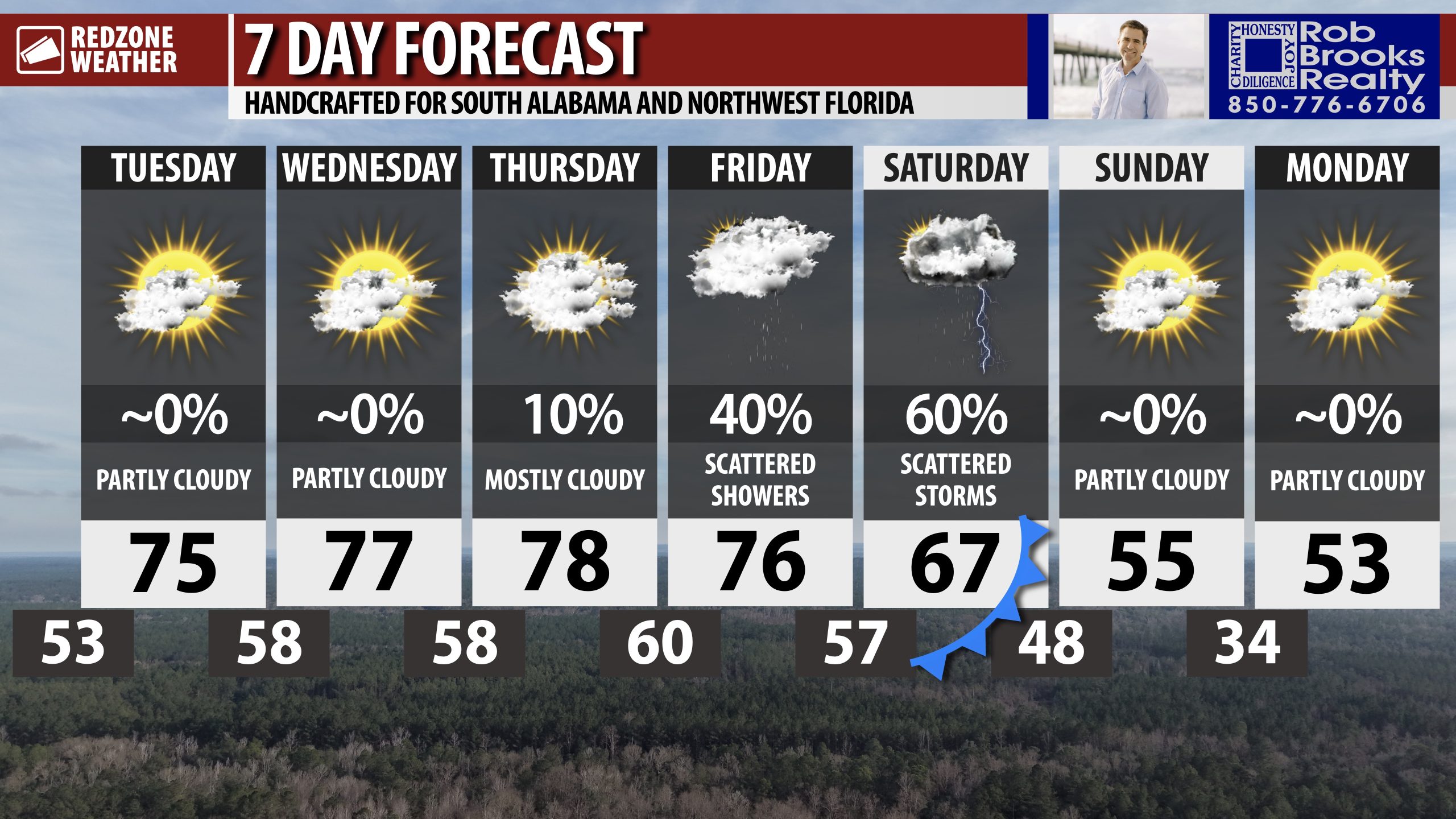
SLIGHTLY WARMER TODAY… Temperatures will be a bit warmer on this Tuesday compared to yesterday. Afternoon highs will be in the mid 70s. Skies will remain mostly cloudy throughout the day.

SLIGHTLY WARMER TODAY; SCATTERED STORMS FRIDAY P.M. INTO SATURDAY… Mostly cloudy skies will persist across south Alabama and northwest Florida on this Tuesday. Temperatures will peak this afternoon in the mid 70s. No rain is expected today or tomorrow. Overnight lows will be in the low to mid 50s tonight. The next chance of rain for our local area will happen Thursday P.M. when spotty showers will become possible. Showers will be possible on Friday locally. Spotty storms are expected on Saturday ahead of a cold front pushing across the region on Saturday night. We have much cooler air set to arrive on Sunday. Afternoon highs will be in the 50s next week.
MILD DAYS, COOL NIGHTS THIS WEEK… Temperatures will be about 10 to 15 degrees above our climatological norms for this time of year today, tomorrow, and on Thursday. Afternoon high temperatures will be in the mid to upper 70s. Overnight lows will consistently be in the 50s through Friday morning.
SEVERE WEATHER RISK TO OUR NORTHWEST ON FRIDAY… The next weather system slated to move through our local area approaches from the northwest on Friday. The Storm Prediction Center has flagged parts of northwest Alabama, much of northern Mississippi, western Tennessee, eastern Arkansas, and northeast Louisiana in a Level 2 (out of 5) severe weather risk valid for Friday into Friday night. This setup will bring a potential for severe storms capable of producing tornadoes, damaging wind gusts, and large hail to those areas. If you’re planning to travel to those areas on Friday or Friday night, please be aware of the potential for severe storms.
SPOTTY SHOWERS & STORMS LOCALLY ON SATURDAY… Rain and thunderstorms will be possible across our local area on Friday night into Saturday. For now, our local area is not involved in a severe weather risk zone, however, I wouldn’t be surprised to see the Storm Prediction Center add a low-end severe weather risk zone valid for late Friday night into Saturday. Storms will likely be spotty in nature, similar to what happened last weekend.
MUCH COOLER EARLY NEXT WEEK… Get ready for winter temperatures to make a return as we get into early next week. High temperatures will be in the 50s by Sunday with overnight lows in the 30s by Monday morning. High temperatures will probably be in the 50s on Tuesday and Wednesday.
APP… If you haven’t already downloaded the RedZone Weather app, now is a great time to do that. redzoneweather.com/app is the link to the free download. Once you have the RZW app installed on your iOS or Android device, be sure to visit the Alerts tab to turn on the specific notifications you’d like to receive. All notifications are handcrafted by me. No automation and we promise not to bug you!
See all the details in your Tuesday morning RedZone Weather forecast video. My next forecast video will be posted by 7:15AM tomorrow morning. I will have updates posted throughout the day, as needed, in the RedZone Weather app.
Have a nice Tuesday!

RAIN POSSIBLE AT TIMES FRIDAY P.M. INTO SATURDAY… Scattered showers and thunderstorms will be possible Friday P.M. into Saturday. Severe storms may be possible Friday P.M. in areas to our north.
High temperatures will be in the mid 70s today, tomorrow, Thursday, and Friday.

The National Weather Service has issued a Dense Fog Advisory valid for all of southwest Alabama and northwest Florida valid through 9AM Tuesday.
Take it slow if driving overnight into the morning hours! pic.twitter.com/da5dSXHTSX
— Spinks Megginson (@rzweather) January 6, 2026
