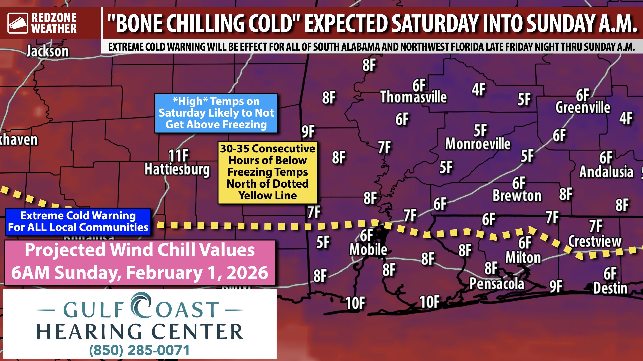
30-35 CONSECUTIVE HOURS OF BELOW FREEZING TEMPS THIS WEEKEND FOR INLAND COMMUNITIES… Afternoon high temperatures (yes, highs, not a typo) won’t get above the freezing mark on Saturday across many communities in south Alabama and northwest Florida, particularly across inland areas. That means that some communities will go below freezing around 2AM Saturday and stay below freezing until 10-11AM on Sunday. The odds are very high Saturday will be the coldest day of 2026. The last time we had a day with temperatures constantly below freezing was January 21, 2025 when the Blizzard of 2025 happened. The difference with this cold coming on Saturday is that, perhaps thankfully in this case, there will be NO snow or precipitation involved.
A FEW RAIN SHOWERS TOMORROW… A few widely scattered rain showers may happen on Friday, mostly in the morning hours. Thankfully, precipitation will be widely spaced and temperatures tomorrow (Friday) during the daytime hours will be well above the freezing mark, thus no snow or mixed precipitation is expected. Black ice is not expected to be a widespread concern Saturday morning as any lingering moisture should have plenty of time to evaporate during the afternoon and evening hours tomorrow.
EXTREME COLD WARNING FOR ENTIRE LOCAL AREA… As of 8:05PM, the entire local area is included in an Extreme Cold Watch, but that will certainly be upgraded to an Extreme Cold Warning tomorrow valid from Friday night through all of Saturday and into Sunday morning. An Extreme Cold Warning is issued when wind chill values will be below 15°. In this case, wind chill values may be in the 10-15° range all day on Saturday across the region. That may sound extreme, but that is the reality we are facing. Let’s look at numbers:
Tomorrow (Friday, January 30): High temperatures will be in the upper 50s inland and in the low 60s closer to the coast. Temperatures will be down right pleasant tomorrow afternoon.
Friday Night: Temperatures rapidly start dropping after a strong cold front moves through. Air temperatures in most communities across south Alabama and northwest Florida will dive below 32° around 2-3AM. Wind chill values will be in the single digits inland with 10s likely closer to the coast.
Saturday: A 10-15 mph wind out of the northwest will act as a constant air conditioner running nonstop all day. This will keep air temperatures below 32° in most communities further inland with mid 30s likely all the way down to the Alabama and northwest Florida beaches. Wind chill values will be in the 10-15° range inland all day Saturday with values in the 15-25° range closer to the coast.
Saturday Night: Coldest night of the year, most likely. Air temperatures will dip into the 14-19° range inland with values of 19-27° closer to the coast. Factor in the wind and you get the wind chill values depicted in the map attached. Single digit wind chills likely inland AND at the coast. 10-15 mph winds expected all night.
Sunday: We finally start breaking the grip of the Arctic ice box. Temperatures will rise above the freezing mark in the 10-11AM hour in most communities. High temperatures will be in the 40s.
WARM UP COMING NEXT WEEK… Afternoon highs on Sunday will be in the 40s. We rise into the 50s on Monday and 60s on Tuesday and Wednesday. Rain may become possible around Wednesday or Thursday of the upcoming week. For now, severe storms seem unlikely, but that’s something I will be monitoring over the next few days.
APP… If you haven’t already downloaded the RedZone Weather app, now is a great time to do that. redzoneweather.com/app is the link to the free download. Once you have the RZW app installed on your iOS or Android device, be sure to visit the Alerts tab to turn on the specific notifications you’d like to receive. All notifications are handcrafted by me. No automation and we promise not to bug you!
I will have the next regularly scheduled RedZone Weather forecast video posted by 7:15AM tomorrow morning. Please let me know if you have specific questions.
Have a great Thursday evening!


