7:30PM January 25, 2026
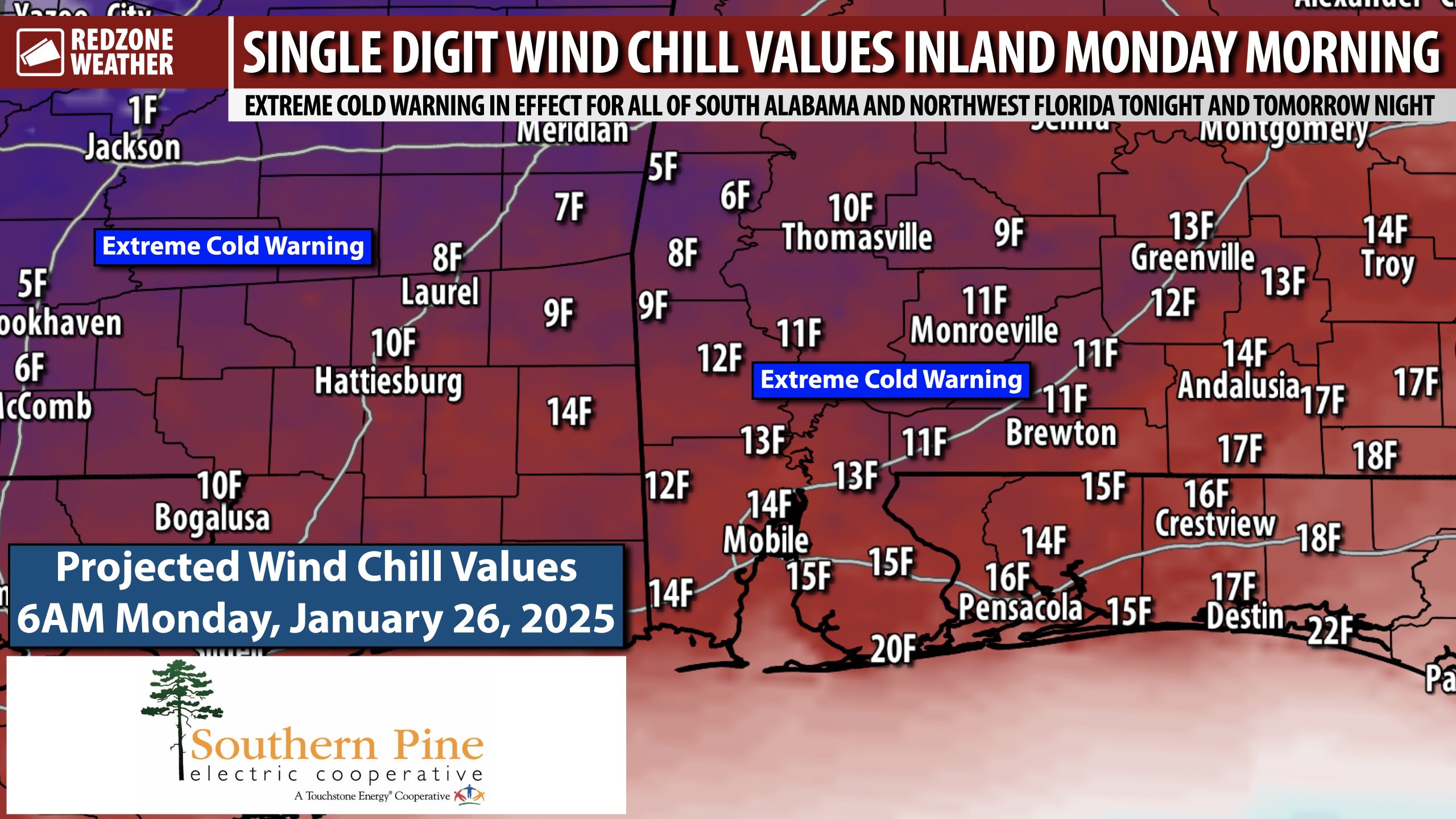
EXTREME COLD WARNING OVERNIGHT; UPDATE ON THE BLACK ICE SITUATION… Overnight lows will be in the 10s inland with low 20s near the coast tonight into early Monday morning. Factor in the ongoing breezy conditions puts wind chill values in the single digits across interior southwest Alabama communities by daybreak Monday. It’s this same wind that should help to largely mitigate widespread, significant black ice concerns across the region. Lingering rain showers are existing to the east quickly this evening. The cold, dry wind should quickly dry up lingering moisture on local roadways in the vast majority of cases. A couple of slick spots may happen tomorrow morning – in areas that typically have puddling on local roadways, but widespread, significant black ice is not expected, per the latest guidance from the National Weather Service office in Mobile.
TEMPERATURES TO DROP BELOW FREEZING AFTER MIDNIGHT IN MOST LOCALES… Cold, dry air will be moving in behind the advancing rain. The wind behind the rain will be in the 5-15 mph range for most of the evening with gusts up to 25 mph. I spoke with a National Weather Service meteorologist about the black ice potential (or lack thereof) this evening. The latest thinking from NWS is that temperatures will drop to near the freezing mark around midnight or 1AM across much of southwest Alabama and by 2-3AM in northwest Florida. NWS points to this as plenty of time for roads to dry out, other than a few areas of black ice in areas that aren’t exposed to the wind. Motorists are encouraged to take it slow tomorrow morning in areas prone to puddles that linger after storms.
EXTREME COLD WARNING FOR OUR AREA… ALL of south Alabama and northwest Florida are involved in an uncommon Extreme Cold Warning due to the very cold temperatures set to happen tonight and tomorrow night. The warning is in effect tonight at midnight to Noon tomorrow. Another Extreme Cold Warning kicks off tomorrow night at midnight and lasts until 10AM Tuesday. This will be an extended hard freeze for our local area. High temperatures tomorrow will only be around the 40 degree mark.
APP… If you haven’t already downloaded the RedZone Weather app, now is a great time to do that. redzoneweather.com/app is the link to the free download. Once you have the RZW app installed on your iOS or Android device, be sure to visit the Alerts tab to turn on the specific notifications you’d like to receive. All notifications are handcrafted by me. No automation and we promise not to bug you!
I will have a full forecast rundown posted in the next regularly scheduled RedZone Weather forecast video that will be posted by 7:15AM tomorrow morning.
Have a nice Sunday evening. Stay warm!


