2:06PM September 19, 2025
Scattered showers and thunderstorms are becoming more numerous this afternoon across south Alabama.
These storms are slowly drifting southward. pic.twitter.com/1cOhs0bGX3
— Spinks Megginson (@rzweather) September 19, 2025

Scattered showers and thunderstorms are becoming more numerous this afternoon across south Alabama.
These storms are slowly drifting southward. pic.twitter.com/1cOhs0bGX3
— Spinks Megginson (@rzweather) September 19, 2025
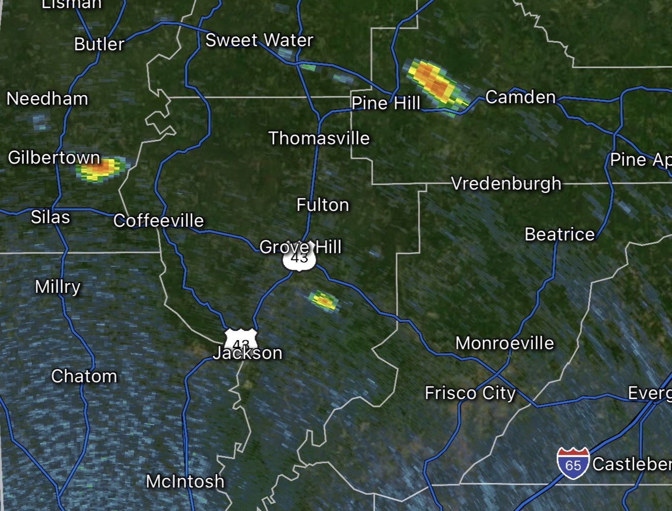
STORMS DEVELOPING OVER WEST ALABAMA… Scattered thunderstorms are developing this afternoon across parts of Clarke, Choctaw, Marengo, and Wilcox counties as of 1:11PM.
More storms will likely develop soon across parts of Monroe and Washington counties as well.
Most communities will remain dry today but isolated downpours will be possible through the evening hours.

The first of what will probably be several showers and thunderstorms over the next few hours has developed in parts of Wilcox County, AL near Yellow Bluff and Possum Bend, just west of Camden.
Be ready for a few showers and storms as we get into the evening hours. pic.twitter.com/DJqXPeM4UM
— Spinks Megginson (@rzweather) September 19, 2025

I’ve seen a good bit of chatter about some Caribbean/Gulf tropical mischief, but there is no imminent concern over the next 5-7 days.
Reminder: Any data, including AI-based data, beyond 7 days out is usually inconsistent and not reliable. pic.twitter.com/UFKGiU3eNm
— Spinks Megginson (@rzweather) September 19, 2025

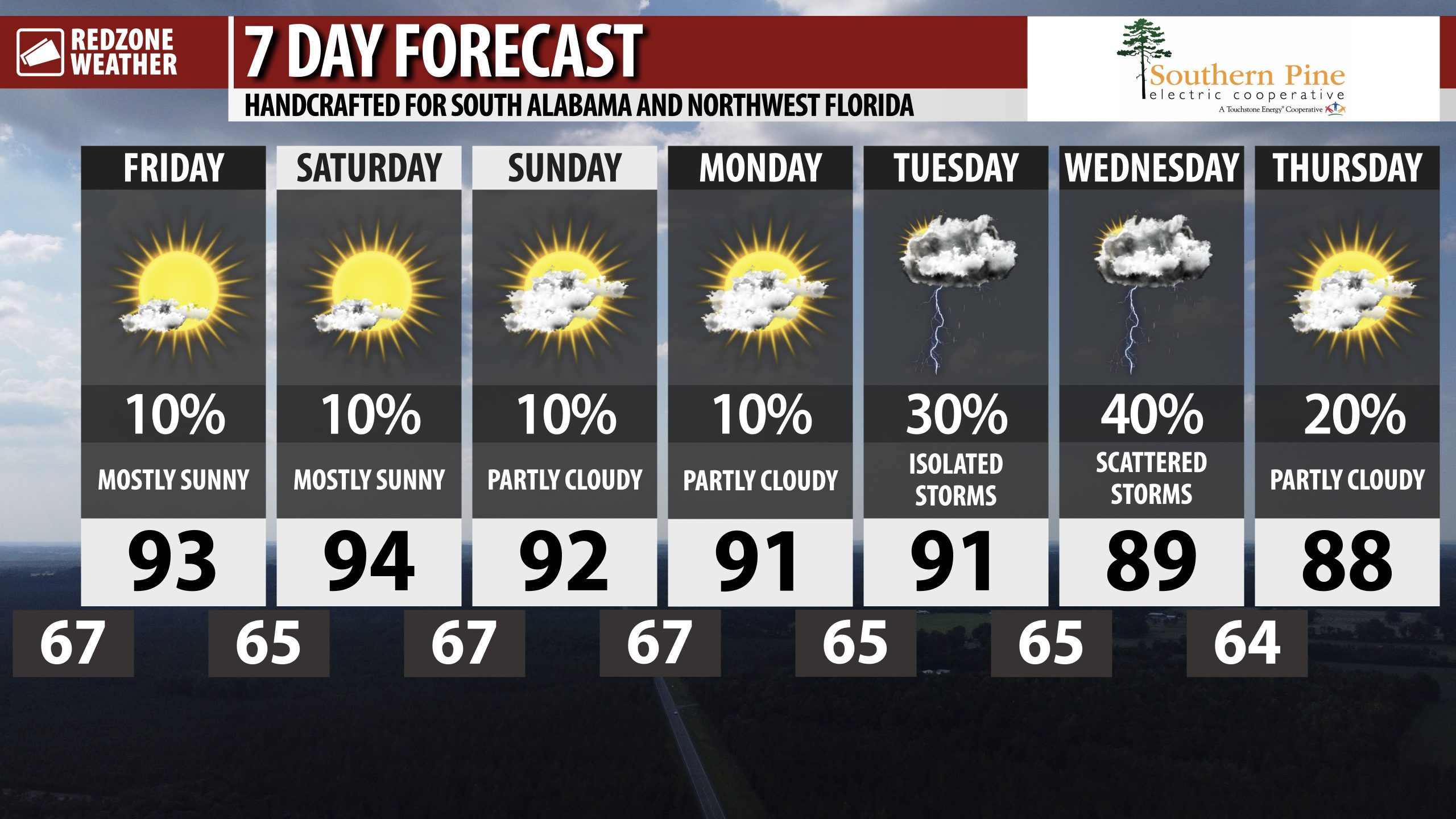
RAIN POSSIBLE AT TIMES NEXT WEEK… Looking forward to the slightly higher rain chances as we get into next week! It will likely not rain all day on Tuesday or on Wednesday, but we will probably will have scattered storms around.
Highs will be in the 90s over the weekend with morning lows in the 60s.

MAINLY DRY WEEKEND; HIGHLY ISOLATED STORMS THIS EVENING… Hot temperatures are expected this afternoon into the evening hours and again on Saturday and Sunday. Highs will be in the mid 90s in many locations today and tomorrow. Isolated showers will be possible today, specifically as we get into the afternoon and evening hours. I expect MOST communities to remain dry but some places may have up to one half inch of rainfall due to pop-up showers and perhaps a few thunderstorms. If your community misses the rain today and tomorrow, we have higher rain chances coming as we get into the middle part of the upcoming week.
HIGH SCHOOL FOOTBALL FORECAST… Most communities will be dry this evening for all of the high school football games across the region. A few sprinkles and showers may be possible during the first half of some of the games across the region. We’ll call the rain chance about a 1 in 10 chance. Severe thunderstorms are not expected. Temperatures around 7PM will still be in the 80s in many spots, falling to around 80 degrees by the end of most of the games.
SLIGHTLY HIGHER RAIN CHANCES NEXT WEEK… Model guidance continues to suggest a wetter pattern as we get into next week, specifically in the middle and latter part of the week. A trough will likely be in place across parts of the eastern U.S. This upper air setup will be one factor that supports a more unsettled, wetter pattern. We probably won’t have “all day washout” events next week, but I am expecting more in the way of scattered storms on Wednesday and Thursday.
TROPICS: TROPICAL STORM GABRIELLE IN ATLANTIC… Tropical Storm Gabrielle remains a weak, disorganized system in the open waters of the Atlantic Ocean this morning. Gabrielle will not be a direct threat to any land areas over the next 4 days. The official forecast track keeps Gabrielle well to the east of the continental United States. Interests in Bermuda should closely monitor the progress of Gabrielle as the system may be a category 1 or category 2 hurricane just east of there in about 3 days. Tropical Storm Gabrielle will never be a direct threat to Alabama or northwest Florida.
TROPICS: CARIBBEAN & GULF REMAIN QUIET… The Gulf and Caribbean Sea are expected to remain quiet over the weekend and into early next week. We note that some of the longer range models are hinting at some development in the 10-12 day range in the western Caribbean Sea, but it’s far too early to know if this will materialize into a real tropical system or if it is model mischief instead. I’ll keep you posted about it in the RedZone Weather app.
APP… If you haven’t already downloaded the RedZone Weather app, now is a great time to do that. redzoneweather.com/app is the link to the free download. Once you have the RZW app installed on your iOS or Android device, be sure to visit the Alerts tab to turn on the specific notifications you’d like to receive. All notifications are handcrafted by me. No automation and we promise not to bug you!
See all the details in your Friday morning RedZone Weather forecast video. My next forecast video will be posted by 7:15AM tomorrow morning. I will have updates posted throughout the day, as needed, in the RedZone Weather app.
Have a great weekend!

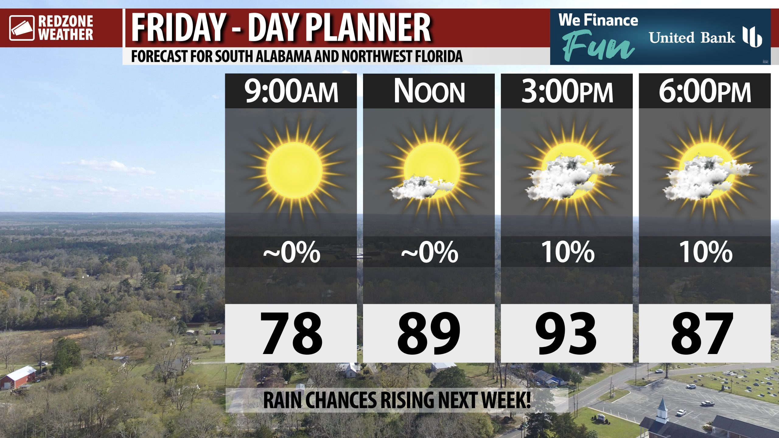
FEW SHOWERS THIS EVENING… There is about a 1 in 10 chance of your community having a few minutes of rain before the end of the day today, particularly if you’re further inland away from the coast.
High temperatures will be in the low 90s today.
Carbon copy forecast on Saturday.
Have a good weekend!
