6:52AM September 18, 2025
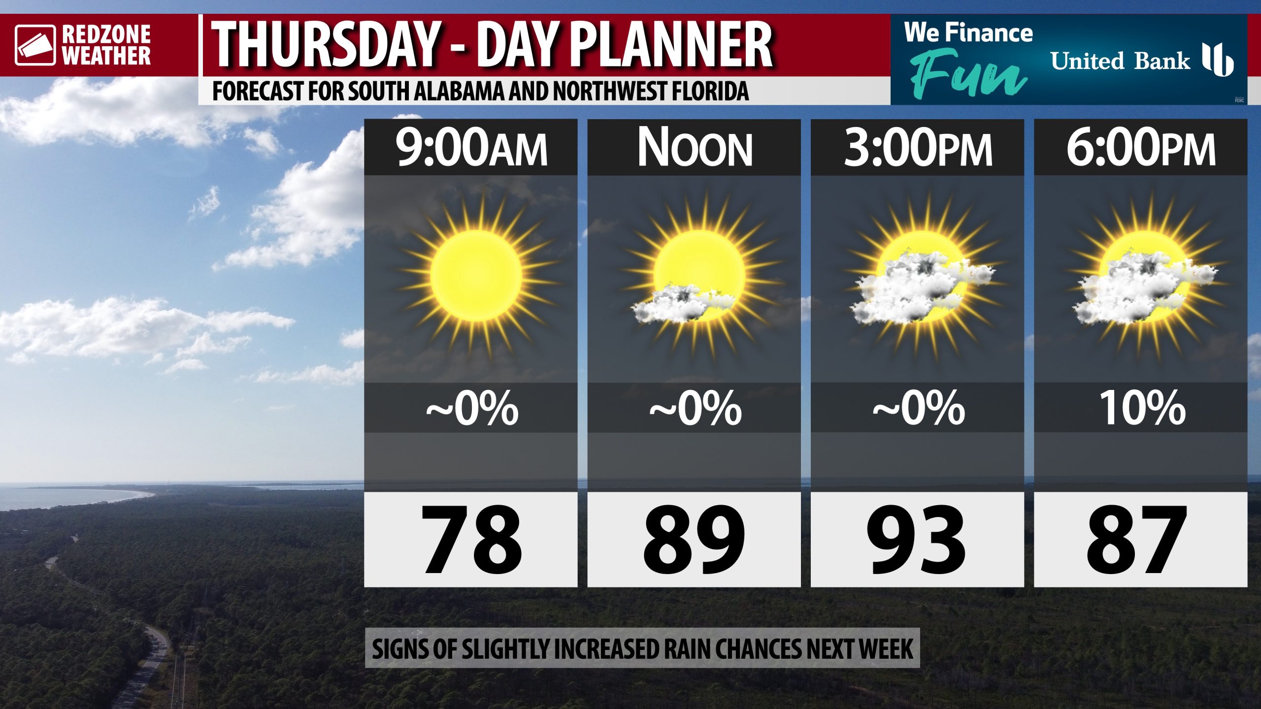
HOT TEMPS THIS AFTERNOON; TRACKING T.S. GABRIELLE IN ATLANTIC… Temperatures will peak in the low to mid 90s this afternoon with mostly sunny skies expected throughout the day on this Thursday. We probably will have scattered cumulus clouds developing in the afternoon hours, just like what we saw yesterday. Rain chances remain quite low across much of the local area. One or two highly isolated sprinkles and showers can’t be ruled out, particularly across inland areas, as we get into the evening hours. After 20 days of inactivity, Tropical Storm Gabrielle formed yesterday in the open waters of the central Atlantic Ocean.
WEEKEND PREVIEW… Partly cloudy skies are expected on both Saturday and on Sunday. High temperatures will continue to be in the low to mid 90s each day with overnight lows in the mid to upper 60s. Rain chances remain quite low, although just like the last few days, a few widely scattered evening sprinkles and showers may happen across the interior stretches of south Alabama.
SLIGHTLY HIGHER RAIN CHANCES NEXT WEEK… Don’t get your hopes up just yet for a big rain event! Rain chances appear to be increasing, however, as we get into next week when more in the way of scattered showers and thunderstorms appear to be more likely. It looks like the best rain chances next week will happen in the middle to latter part of the week. High temperatures will remain above our climatological norms for this time of year. Most communities will be in the low to mid 90s for afternoon highs, 4-7° above our norms for this time of year.
TROPICS: TROPICAL STORM GABRIELLE IN ATLANTIC… The National Hurricane Center initiated advisories yesterday on Tropical Storm Gabrielle, now located about 970 miles east of the northern Leeward Islands in the central Atlantic Ocean. Gabrielle will not be a direct threat to any land areas over the next 4 days. The official forecast track keeps Gabrielle well to the east of the continental United States. Interests in Bermuda should closely monitor the progress of Gabrielle as the system may be a category 1 or category 2 hurricane just east of there in about 5 days. Tropical Storm Gabrielle will almost certainly never be a direct threat to Alabama or northwest Florida.
TROPICS: TWO OTHER TROPICAL WAVES EAST OF GABRIELLE… In addition to Tropical Storm Gabrielle, we’re monitoring two tropical waves in the tropics. One of the tropical waves is near the Cabo Verde Islands in the eastern Atlantic Ocean. This feature has a 20% chance of becoming a named tropical storm in the days ahead as the tropical wave moves westward. After clearing the Cabo Verde Islands, the tropical wave will be no threat to land for 4-5 days. Another, separate tropical wave, currently drifting westward over west-central Africa, will move into the eastern Atlantic Ocean by Friday evening. This tropical wave will need to be monitored for potential development next week as well.
TROPICS: CARIBBEAN & GULF REMAIN QUIET… The Gulf and Caribbean Sea are expected to remain quiet over the next 5-7 days with no named tropical storms expected.
APP… If you haven’t already downloaded the RedZone Weather app, now is a great time to do that. redzoneweather.com/app is the link to the free download. Once you have the RZW app installed on your iOS or Android device, be sure to visit the Alerts tab to turn on the specific notifications you’d like to receive. All notifications are handcrafted by me. No automation and we promise not to bug you!
See all the details in your Thursday morning RedZone Weather forecast video. My next forecast video will be posted by 7:15AM tomorrow morning. I will have updates posted throughout the day, as needed, in the RedZone Weather app.
Have a nice Thursday!