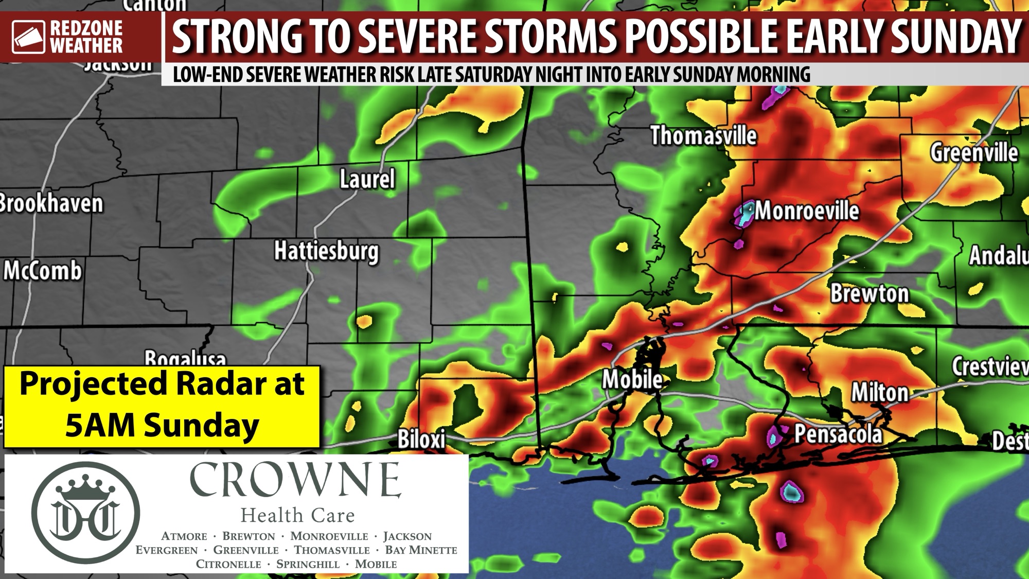
STRONG STORMS POSSIBLE SATURDAY NIGHT INTO SUNDAY MORNING… Active weather returns to our region Saturday night into Sunday morning as a cold front approaches from the northwest. There is a chance that a few strong to severe thunderstorms will be involved. Most locales across south Alabama and northwest Florida will simply have rain at times and thunder. A few storms, however, may become severe with gusty winds being the main concern. The tornado risk remains low, but not entirely zero.
SEVERE WEATHER TIMING – SATURDAY NIGHT INTO SUNDAY… 11PM Saturday night to 11AM Sunday morning is the current window for strong to severe thunderstorms to happen across south Alabama and northwest Florida. Most communities across south Alabama and northwest Florida will simply have occasional rain and thunder at times but a few, brief severe storms may become possible from Saturday night into Sunday morning. We encourage everyone to have multiple ways to hear urgent weather warnings just in case a warning becomes required for your specific location.
LOW-END SEVERE WEATHER RISK… The western half of our local area is involved in the low-end, Level 1 (out of 5) severe weather risk valid from Saturday night into Sunday morning. Communities WEST of a line from Foley to Walnut Hill to Atmore to Monroeville are involved in the low-end risk zone. This includes places like Mobile, Prichard, Saraland, Satsuma, Bayou La Batre, Alabama Port, Wilmer, Dauphin Island, Citronelle, Calvert, Chatom, Millry, Wagerville, Vinegar Bend, Leroy, Jackson, Grove Hill, Thomasville, Whatley, Coffeeville, Perdue Hill, Uriah, Bay Minette, Daphne, Fairhope, Spanish Fort, Magnolia Springs, Robertsdale, Silverhill, Summerdale, and Loxley. Communities further to the east like Pensacola, Milton, Brewton, Evergreen, Andalusia, Destin, Fort Walton Beach, and Crestview are involved in the General Thunderstorms zone.
LINE OF STORMS TO APPROACH LATE SATURDAY NIGHT… The reason the western half of our local area is involved in a low-end severe weather risk zone and the eastern half of the region is not involved in a risk zone is because we are expecting a line of thunderstorms to be weakening while crossing the region from west to east. There is a bit of uncertainty as to the strength of the line of storms when it approaches our region. The line may be weak as it approaches west Alabama, and in that case the severe weather risk would probably be quite limited across the region. If the line of storms is a bit stronger on approach, there is a chance that a few stronger storms may happen across the region as the line progresses eastward.
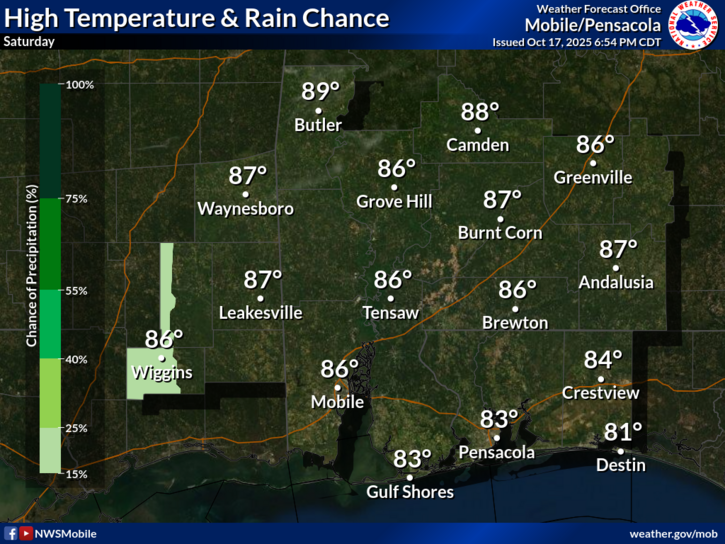
BENEFICIAL RAIN EXPECTED… Drought conditions across south Alabama and northwest Florida continue to worsen each day due to a significant lack of rainfall. This event on Saturday night into Sunday should help to at least put a dent into drought conditions with MOST communities across the region now projected to pick up between 0.5″ and 1.5″ of rainfall in total through Sunday.
COOLER TEMPS COMING SUNDAY NIGHT… A cold front approaching the local area is the forcing mechanism responsible for this low-end severe weather risk on Saturday night into Sunday morning. This cold front will move through Sunday afternoon behind the advancing line of storms. Cooler, drier weather will happen on Sunday night, Monday, into Tuesday. Overnight lows by Monday morning will likely be in the upper 40s in many communities across the region. Highs on Monday will top out in the upper 70s.
APP… If you haven’t already downloaded the RedZone Weather app, now is a great time to do that. redzoneweather.com/app is the link to the free download. Once you have the RZW app installed on your iOS or Android device, be sure to visit the Alerts tab to turn on the specific notifications you’d like to receive. All notifications are handcrafted by me. No automation and we promise not to bug you!
I will have another update posted on Saturday along with rolling updates in the RedZone Weather app.
Have a nice Friday evening!