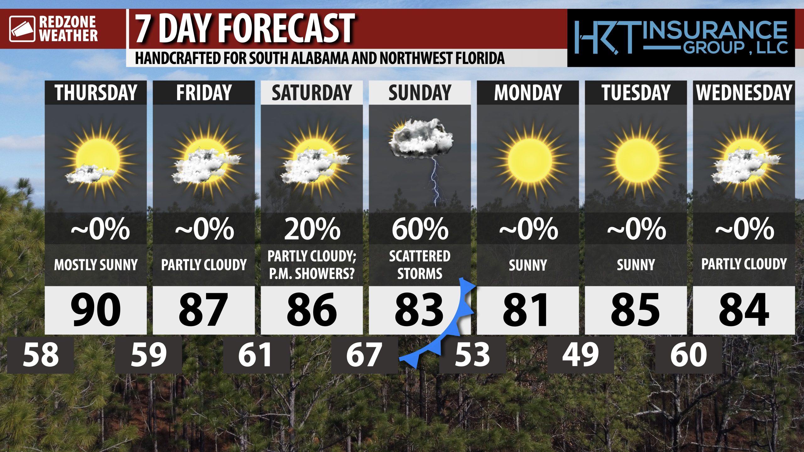
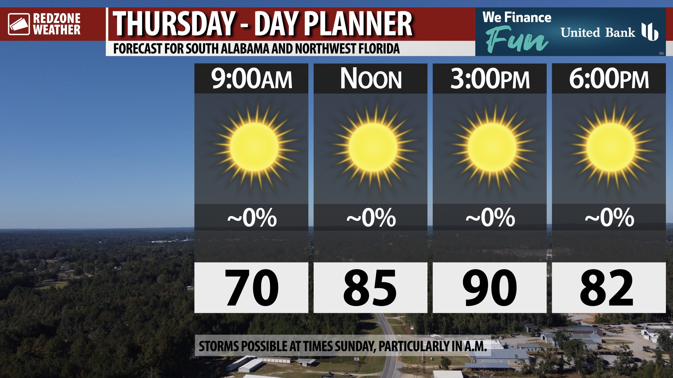
SUNNY THURSDAY; SPOTTY STORMS AT TIMES SATURDAY NIGHT INTO SUNDAY… Rain may be possible in some communities this weekend but before we get there, ample sunshine is expected across south Alabama and northwest Florida on this Thursday. High temperatures will be in the upper 80s and near the 90 degree mark. More dry weather is expected on Friday ahead of the potential for a few showers and storms late Saturday night into Sunday when a cold front will approach our region from the northwest.
INCREASING CLOUDINESS TOMORROW NIGHT INTO SATURDAY… Mostly sunny skies are likely for much of the day on Friday ahead of partly cloudy skies tomorrow night. If you have evening plans tomorrow night, temperatures will likely be in the 70s between 7PM and 10PM with dry conditions. Partly cloudy skies are also expected on Saturday.
SCATTERED STORMS SATURDAY NIGHT INTO SUNDAY… Showers and thunderstorms will likely remain scattered in nature this weekend, meaning some communities may not have much rain at all. Generally speaking, inland communities will probably have more rain than communities closer to the coast. This means that places like Thomasville, Monroeville, Camden, and Greenville will have higher rain chances on Saturday night and Sunday compared to places closer to the coast like Bayou La Barre, Daphne, Foley, Pensacola, Navarre, Fort Walton Beach, Niceville, and Destin. Widespread sever storms seem unlikely, but I am expecting some thunder at times Saturday night into Sunday. There is a chance the Storm Prediction Center includes parts of our region in a low-end, Level 1 (out of 5) severe weather risk on Saturday into Sunday.
COOLER AIR ARRIVES SUNDAY NIGHT INTO MONDAY… Cooler, drier air arrives Sunday afternoon after the passage of the cold front responsible for our rain chances this weekend. Overnight lows by 6AM Monday will be in the low 50s. Afternoon highs on Monday will be near the 80 degree mark.
BEAUTIFUL START TO NEXT WEEK… Temperatures may be in the upper 40s by Monday night into early Tuesday morning. Cool mornings are expected to persist next week with afternoon highs projected to be in the low to mid 80s on Tuesday and Wednesday. Dry conditions are expected Monday, Tuesday, and Wednesday across south Alabama and northwest Florida.
TROPICAL UPDATE: ATLANTIC BASIN QUIET… Tropical Storm Lorenzo has dissipated. The National Hurricane Center issued their final advisory on Lorenzo last evening. That means the entire Atlantic Basin, including the Gulf and Caribbean Sea are now quiet with no new tropical storms expected to form over the next 5-7 days. We note that some of the longer range global models are hinting at the potential for some tropical mischief in the Caribbean Sea in 10 or so days. For now, we enjoy the quiet conditions in the tropics with no named storms. The 2025 Atlantic Hurricane Season will end on Sunday, November 30.
APP… If you haven’t already downloaded the RedZone Weather app, now is a great time to do that. redzoneweather.com/app is the link to the free download. Once you have the RZW app installed on your iOS or Android device, be sure to visit the Alerts tab to turn on the specific notifications you’d like to receive. All notifications are handcrafted by me. No automation and we promise not to bug you!
See all the details in your Thursday morning RedZone Weather forecast video. My next forecast video will be posted by 7:15AM tomorrow morning. I will have updates posted throughout the day, as needed, in the RedZone Weather app.
Have a nice Thursday!