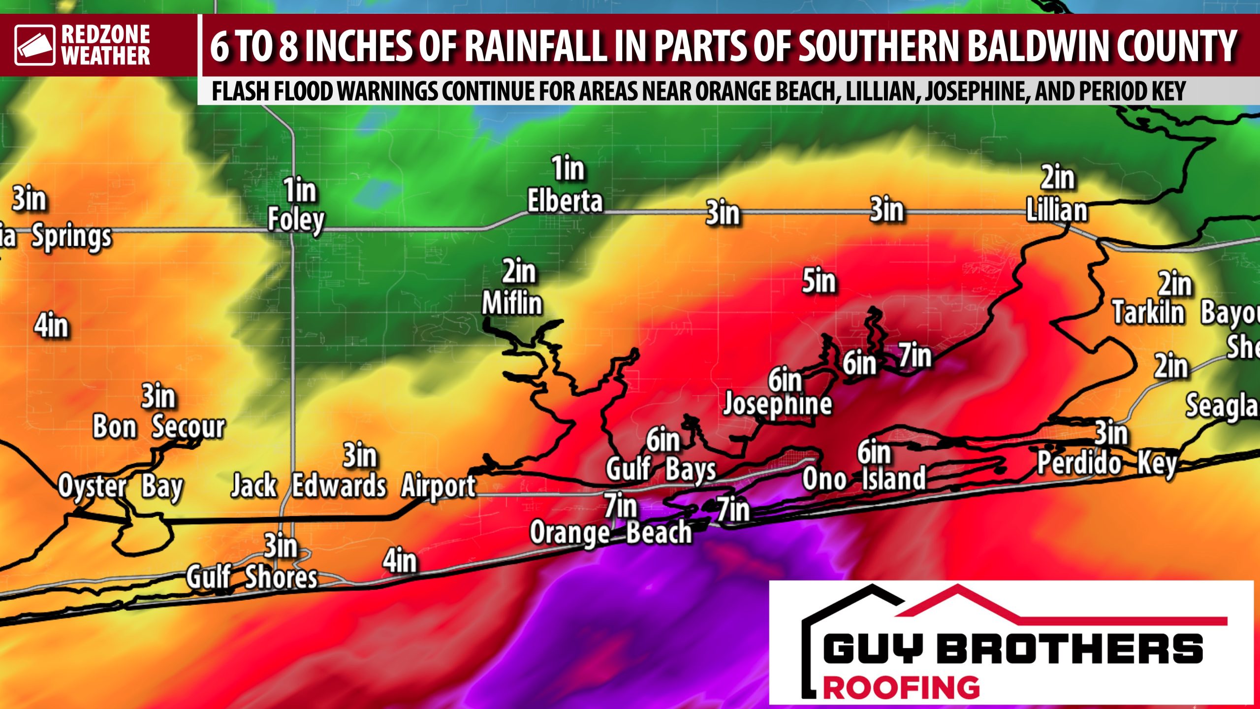
UPDATE ON SEVERE WEATHER RISK; FLASH FLOOD NEAR OBA… Ongoing rain across the region, particularly in southern Baldwin (AL) and Escambia (FL) counties, is making a serious flash flood situation even worse. 7.8 inches of total rainfall have happened so far today at the Orange Beach City Hall. 6.7 inches of total rain so far today at Ono Island. Multiple reports of flash flooding near Lillian have come in over the last few minutes. Rain amounts have generally been much more manageable everywhere else across the region, so far. Please let us know how much rain you have received!
TURN AROUND, DON’T DROWN… We lose entirely too many folks across this nation trying to cross a water-covered roadway in a vehicle. That is a bad idea. Please don’t do it if you find yourself in that situation.
SEVERE WEATHER RISK NEAR THE NORTHWEST FLORIDA COAST… The main hotspot I am watching over the next couple of hours (through 4PM) will be near the northwest Florida coast. A large group of storms is currently passing Ft. Pickens and Pensacola Beach with most of the action in the northern Gulf about 10-15 miles offshore. It is good news that the bulk of the storms are remaining offshore, for now, as significant rotation has been observed in these storms. I will be watching these storms carefully as they move by Gulf Breeze, Pensacola Beach, Midway, Tiger Point, Navarre, Fort Walton Beach, and Destin over the next couple of hours.
WHAT TO EXPECT – THIS EVENING INTO TONIGHT… Scattered showers and thunderstorms may develop over eastern Louisiana and southeast Mississippi that ultimately move into southwest Alabama and northwest Florida later this evening. Uncertainty in this second round of storms is high, as it remains to be seen just how much the first round of storms today has worked over the atmosphere. We will continue to be in this regime of a low-end severe weather risk well into the evening hours with the greatest concern near the coast. If you’re further inland in Escambia (AL), Monroe, Conecuh, Clarke, Washington, Butler, Covington counties, or points north, there is a very, very high likelihood you won’t have severe weather issues. The risk may not be entirely zero, but it’s pretty close. The warm, unstable air remains trapped closer to the coast south of a stationary/warm front. The severe weather risk is low for Mobile, Baldwin, Escambia (FL), Santa Rosa, Okaloosa, and Walton counties, with a slightly higher risk at the immediate coastline of the beaches and bays. Expect rain at times across the region with occasional thunder.
TORNADO WARNING POLICY… Any time there is an active tornado warning in effect for southwest Alabama or northwest Florida, we provide uninterrupted, live video coverage on Facebook Live and YouTube Live. Our detailed coverage commitment is outlined at redzoneweather.com/coverage. We are proud to cover all parts of Escambia (AL), Covington, Monroe, Conecuh, Baldwin, Mobile, Clarke, Washington, Butler, Escambia (FL), Santa Rosa, and Okaloosa counties. If you live in any locale in those counties, be sure to tune into our coverage whenever there is an active tornado warning!
APP ALERTS… redzoneweather.com/app is the link where you can download the free RedZone Weather app. We post brief updates throughout each day in the app, keeping you up-to-date about the latest happenings in weather across south Alabama and northwest Florida. Once you have the free app downloaded to your iOS or Android device, be sure to visit the Alerts tab (lower right corner) then tap the large Alert Settings button to customize the alerts you would like to receive straight from me.
I will have more updates posted throughout the evening in the RedZone Weather app.
Have a nice Sunday evening!


