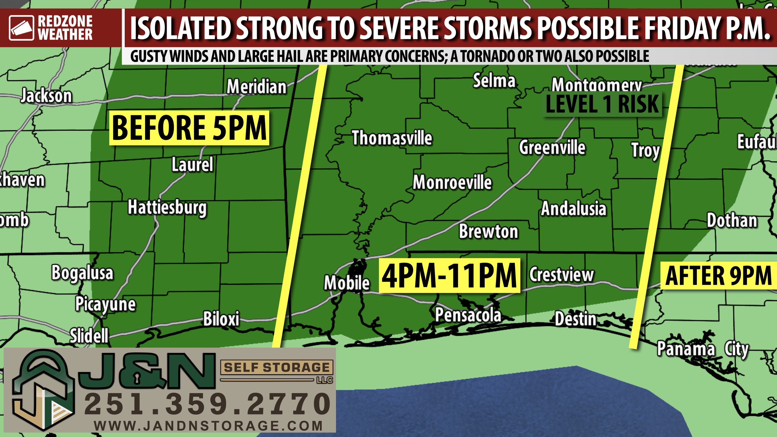
SPOTTY STORMS FRIDAY P.M. MAY BECOME STRONG OR SEVERE; STORMS TO BE WIDELY SCATTERED… Isolated strong to severe thunderstorms will become possible on Friday in the evening hours across south Alabama and northwest Florida. This will be a unique severe weather setup in that thunderstorms will probably remain quite isolated in nature. That means there is a real chance some communities across the region will have NO rain tomorrow into tomorrow night. Where storms do fire up, however, large hail, gusty winds, and even a tornado or two may become possible. We have nearly all of the local area involved in a low-end, Level 1 (out of 5) severe weather risk zone valid for Friday into Friday night. Separately, another low-end severe weather risk will set up on Saturday evening ahead of sharply colder and drier temperatures coming behind an advancing cold front on Sunday evening.
SEVERE WEATHER TIMING – FRIDAY… While isolated strong storms will be possible on both Friday and Saturday, it’s important we look at these events separately as we probably will have a lull in between the activity tomorrow night and the storms that develop on Saturday in the evening hours. 2PM Friday to 2AM Saturday is the twelve hour window for the first round of storms with 4PM to 11PM Friday being the main seven hour window. Thunderstorms are very likely to be highly isolated in nature, meaning it will NOT rain in every, single community across the region. Another round of spotty thunderstorms may develop on Saturday afternoon and evening with at least some potential for a few strong to severe storms across inland areas of southwest Alabama.
EXPLAINING A LOW-END, LEVEL 1 (OUT OF 5) RISK… November and December usually see an uptick in severe weather activity across the Deep South and this year is proving to be no exception already. The severe weather risk zone we are involved in valid for Friday is a low-end, Level 1 (out of 5) risk. It’s the “lowest level risk,” but it’s a risk nonetheless. These risk zones are derived from the Storm Prediction Center convective outlook, issued multiple times daily. A Level 1 risk zone means that widespread, significant severe storms are not expected, but a few stronger storms cannot completely be ruled out. Can tornadoes happen on a low-end risk day? Yes, absolutely possible, but certainly not a guarantee! Anytime there is a risk in place for our region, I encourage everyone to have multiple ways to hear urgent weather warnings, just in case your specific location goes under a tornado warning.
ANOTHER LOW-END RISK ON SATURDAY… Our local weather pattern on Saturday will probably be quite similar to what happens on Friday. Another round of highly isolated thunderstorms will be possible, including at least some risk of a few stronger storms. This second batch of storms will probably happen on Saturday evening locally. It won’t rain in every community but there may be a few highly isolated stronger storms around.
SHARPLY COLDER AIR ON THE WAY… The coldest air of the season so far is slated to arrive on Sunday evening. Highs on Saturday will be in the low 80s with highs in the 70s on Sunday. Temperatures nosedive Sunday night and we’re headed to overnight lows in the mid 30s at 6AM on Monday. Highs on Monday will struggle to get to the mid 50s (!) with overnight lows on Tuesday morning in the 20s in many communities.
APP… If you haven’t already downloaded the RedZone Weather app, now is a great time to do that. redzoneweather.com/app is the link to the free download. Once you have the RZW app installed on your iOS or Android device, be sure to visit the Alerts tab to turn on the specific notifications you’d like to receive. All notifications are handcrafted by me. No automation and we promise not to bug you!
My next detailed forecast update will be posted in the regularly scheduled morning video. Look for that tomorrow morning at 7:15AM. Have a nice Thursday evening!
