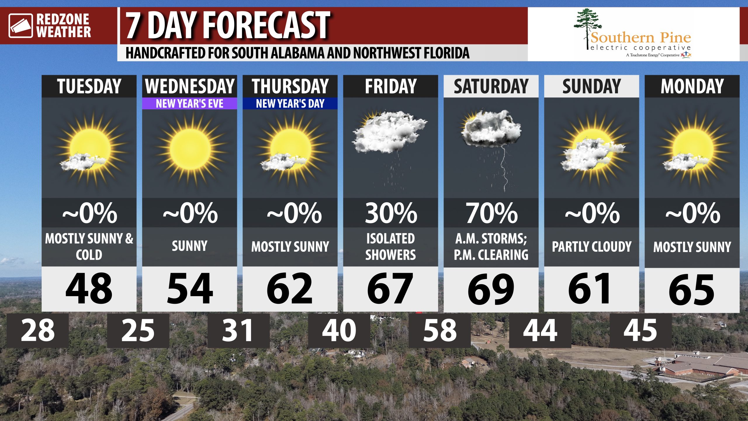
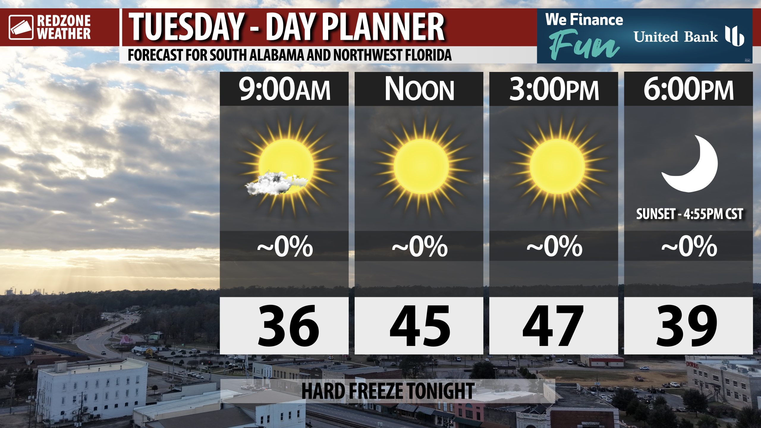
HIGHS IN 40s TODAY; HARD FREEZE TONIGHT; DRY FOR NEW YEAR’S EVE… Today will be the coldest day of the week with high temperatures set to top out in the upper 40s across south Alabama and northwest Florida. Skies will be sunny throughout the day as a cold, very dry air mass remains in place across the region. Temperatures will be in the 30s by 6PM in many spots, falling below freezing after 9PM. Most communities will be in the mid to upper 20s by daybreak Wednesday morning. Dry conditions are expected as we kick off the Year 2026. Scattered showers and thunderstorms will become possible late Friday into Saturday. There may be a few strong to severe thunderstorms involved with that passing system Friday night into early Saturday. Details remain murky at this point.
TEMPS BELOW FREEZING TONIGHT; FREEZE PRECAUTIONS NEEDED… If you happen to put sensitive plants outside, you’ll need to bring the plants back inside before tonight as widespread subfreezing temperatures are expected across the region. Outdoor pets should also be brought inside. Temperatures will be as low as 23-25° near places like Thomasville, Monroeville, Beatrice, Millry, Gilbertown, Forest Home, Georgiana, McKenzie, Lyeffion, and Greenville. Overnight lows of 26-28° are likely as far south as Mobile, Loxley, Spanish Fort, Pensacola, Milton, Crestview, Niceville, and Fort Walton Beach.
COLD, DRY WEATHER FOR NEW YEAR’S EVE… Afternoon highs will rebound into the 50s tomorrow. New Year’s Eve across south Alabama and northwest Florida will be dry and cold. Temperatures around 6PM on Wednesday evening will be in the mid 40s. We’ll be in the mid 30s by 10PM and around midnight early Thursday morning as we ring in the Year 2026, temperatures will be around 34°. Clouds will increase in coverage on New Year’s Day on Thursday ahead of our next rain chance on Friday.
MILDER WEATHER ARRIVES FOR NEW YEAR’S DAY… Skies will likely be mostly sunny on Thursday morning as we wake up to a New Year. Temperatures will be in the mid 60s Thursday afternoon. Clouds will increase in coverage throughout the day ahead of a chance of rain and thunderstorms setting up for Friday into Saturday.
SCATTERED STORMS POSSIBLE FRIDAY P.M. INTO SATURDAY; SEVERE STORMS POSSIBLE… Scattered strong to severe thunderstorms may become possible across parts of the Deep South, including locally in south Alabama and northwest Florida, on Friday night into early Saturday morning. While it is impossible to resolve specific details, like what communities may have the worst of the weather, there are signals that a few severe storms may happen. This is because an area of low pressure will likely develop to our northwest and gradually shift eastward. This would put our region in the warm, unstable sector where storms may become possible. Please check back in for updates over the next few days. Details will become more clear as we get closer to the severe weather potential.
APP… If you haven’t already downloaded the RedZone Weather app, now is a great time to do that. redzoneweather.com/app is the link to the free download. Once you have the RZW app installed on your iOS or Android device, be sure to visit the Alerts tab to turn on the specific notifications you’d like to receive. All notifications are handcrafted by me. No automation and we promise not to bug you!
See all the details in your Tuesday morning RedZone Weather forecast video. My next forecast video will be posted by 7:15AM tomorrow morning. I will have updates posted throughout the day, as needed, in the RedZone Weather app.
Have a nice Tuesday!