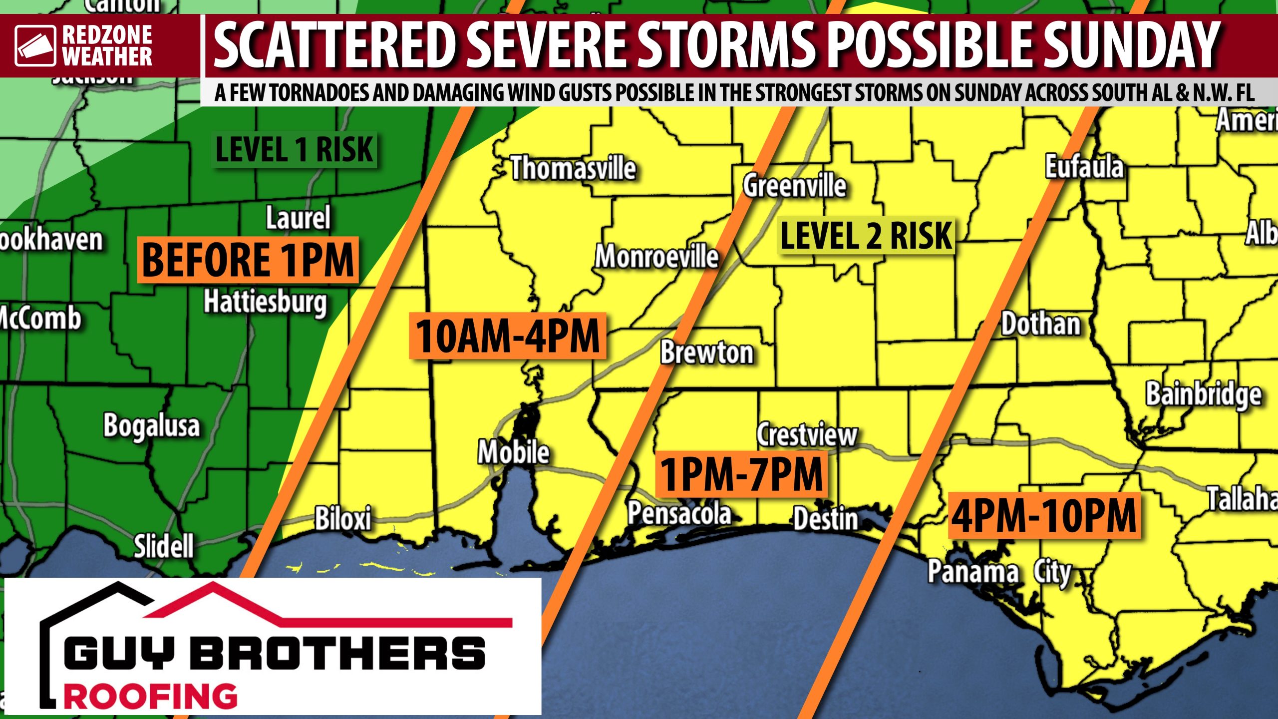
INCREASING RISK OF A FEW TORNADOES SUNDAY… Scattered strong to severe thunderstorms may become possible on Sunday ahead of an advancing strong cold front. The Storm Prediction Center has upgraded ALL of south Alabama and northwest Florida to be included in their Level 2 (out of 5) severe weather risk valid for Sunday, January 25, 2026. Tornadoes and damaging wind gusts will be possible as a robust line of thunderstorms develops and moves eastward.
SEVERE WEATHER TIMING – SUNDAY… The window for strong to severe storms across south Alabama and northwest Florida will be from 10AM to 7PM on Sunday with the core risk happening from Noon to 6PM. Early morning (6-10AM) storms could become possible under some scenarios, but confidence in that idea remains low.
RAIN LIKELY AT TIMES TONIGHT… Scattered rain showers will be possible across south Alabama and northwest Florida tonight into early Sunday. I am tracking a mass of rain and thunderstorms developing near Baton Rouge (LA), Lafayette (LA), and New Iberia (LA) that is gradually spreading eastward. This mass of rain will ultimately move into southeast Mississippi, south Alabama, and northwest Florida this evening into tonight. I am not expecting severe weather issues locally tonight as all of the warm, unstable air will very likely be confined to the southwest of our region. This unstable air will spread across our region tomorrow behind an advancing warm front (that is out ahead of the cold front).
WHAT TO EXPECT – SUNDAY… Spotty showers will be possible early tomorrow morning ahead of the developing line of strong to severe storms. Some of the high-res models have hinted at the potential for a few severe storms earlier in the morning (6-8AM time frame) but I tend to discount this scenario at this time due to the expectation of warmer air being confined to the offshore zones during the early morning hours. IF (and that’s a big IF) warmer air moves inland earlier in the morning, we may have a few isolated severe storms earlier in the morning. A line of strong to severe storms will develop in the 9AM-Noon range across parts of southeast Mississippi and west Alabama. This line of storms will be moving eastward in the afternoon hours, sweeping across the region through the early evening hours. Damaging wind gusts and embedded tornadoes are the concerns as the line of storms moves across the region. A few isolated storms may develop immediately ahead of the line that could produce tornadoes, but confidence on this idea is low. Confidence in line of storms is quite high, however. Rain amounts of 1-2″ will be possible across the region. Widespread flash flooding is not expected.
WINTER STORM HAPPENING TO OUR NORTH… The heavily advertised winter storm is now in progress across areas to our north. Freezing rain is happening in parts of north Mississippi as of 1PM Saturday. Snow is falling across a large portion of Tennessee and Kentucky. Sleet is being observed as far south as Greenwood, Mississippi. Travel to these zones is STRONGLY discouraged this weekend into early next week. Air travel across the nation will be severely crippled due to major ice issues affecting Atlanta, Houston, Dallas, Charlotte, D.C., New York, and other major airports. This will be the most significant and widespread winter storm the nation has had in at least 10-15 years.
VERY COLD AIR ARRIVES SUNDAY NIGHT… Very cold air arrives tomorrow night into Monday morning. An Extreme Cold Watch remains in effect at the time I am writing this (1PM Saturday), but this will need to be upgraded to an Extreme Cold Warning or a Wind Chill Advisory soon. That technicality doesn’t really mean much. The bottom line is VERY cold temperatures are expected this week. 7-8 nights of below freezing temperatures are LIKELY with most (if not all) of those nights featuring lows in the mid to upper 20s across much of the region. This will be a prolonged cold snap. High temperatures on Monday will be in the upper 30s inland with low 40s closer to the coast.
UPDATE ON BLAK ICE CONCERNS MONDAY MORNING… Cold, dry air will rapidly move into south Alabama and northwest Florida Sunday night into Monday morning after the passage of the rain and storms. Lingering moisture on area roadways could create isolated areas of black ice. The greatest chance of black ice will happen in parts of Clarke, Washington, Mobile, Choctaw, and Marengo counties in the western stretch of Alabama due to colder air rushing in more quickly. These counties have a slightly higher probability of black ice compared to counties further east. Counties further east will have more time to dry out before the very cold temperatures arrive. Regardless, we encourage everyone to take it slow on Monday morning in case a lingering puddle or two freezes over on local roadways.
NEXT WEEKEND MORE LIKELY TO BE SUNNY & QUIET… Model support for a snow/winter storm event NEXT weekend has collapsed, meaning all of the major global models are now showing sunny, dry weather for the local area. While it is far too early to rule out snow, for sure, it appears model support for a sunny, quiet pattern appears to be increasing. Models basically show the area of low pressure developing about 500 miles to our south and remaining far enough south in the Gulf that no precipitation would happen locally. This is something that will need to be monitored over the next few days as changes will be possible. I would question any “source” that has promoted a snow potential 7-10 days out – a totally irresponsible and unwise thing to do considering it is nearly impossible to forecast snow in the Deep South 3-4 days out, let alone 7-10 days.
TORNADO WARNING POLICY… Any time there is an active tornado warning in effect for southwest Alabama or northwest Florida, we provide uninterrupted, live video coverage on Facebook Live and YouTube Live. Our detailed coverage commitment is outlined at redzoneweather.com/coverage. We are proud to cover all parts of Escambia (AL), Covington, Monroe, Conecuh, Baldwin, Mobile, Clarke, Washington (AL), Butler, Escambia (FL), Santa Rosa, and Okaloosa counties. If you live in any locale in those counties, be sure to tune into our coverage whenever there is an active tornado warning!
APP ALERTS… redzoneweather.com/app is the link where you can download the free RedZone Weather app. We post brief updates throughout each day in the app, keeping you up-to-date about the latest happenings in weather across south Alabama and northwest Florida. Once you have the free app downloaded to your iOS or Android device, be sure to visit the Alerts tab (lower right corner) then tap the large Alert Settings button to customize the alerts you would like to receive straight from me.
I will have plenty of updates posted in the hours ahead in the RedZone Weather app.
Have a nice Saturday evening!
