10:03AM January 31, 2026
Reports of snow, with no accumulation, yet, in Greenville, this morning. @rzweather
— 1775 or 1860? (@ScobieSr) January 31, 2026

Reports of snow, with no accumulation, yet, in Greenville, this morning. @rzweather
— 1775 or 1860? (@ScobieSr) January 31, 2026
Cold and windy Sunrise Canoe,AL @spann @NWSMobile @rzweather @ThomasGeboyWX @AlanSealls @WKRGEd @CloudAppSoc @StormHour #alwx #sunrise pic.twitter.com/gGiz0gWz5g
— Ditto Gorme (@dittogorme) January 31, 2026

VERY COLD TODAY; GUSTY WINDS POSSIBLE… Today will likely end up being the coldest day of 2026. Air temperatures will remain below the freezing mark in most communities locally with wind chill values in the 10s and 20s all day. A Wind Advisory is in effect today due to 15-25 mph wind gusts being possible. Stay warm!

Well, we have been thrown into the freezer, but how long will the sub-freezing temperatures last? Near the coast, you're in luck as temperatures "warm" into the middle 30's briefly this afternoon! Over the interior, it stays frigid near or below freezing through Sunday morning. pic.twitter.com/0t0D1qcO34
— NWS Mobile (@NWSMobile) January 31, 2026

Wind gusts of 25-35 mph will be possible throughout the day tomorrow. A Wind Advisory is in effect for all local counties. Temperatures will peak in the 28-32° range tomorrow in many spots. Be ready for a VERY cold Saturday. 🥶 pic.twitter.com/7bG4a2ENwT
— Spinks Megginson (@rzweather) January 31, 2026

It will also get quite windy late tonight into Saturday. Frequent gusts to as high as 40-45 mph are possible and a Wind Advisory is now in effect for our NW Florida and SW Alabama counties. Gusty winds may persist through Sunday morning along the immediate coast. pic.twitter.com/E1Spq4Anwr
— NWS Mobile (@NWSMobile) January 30, 2026

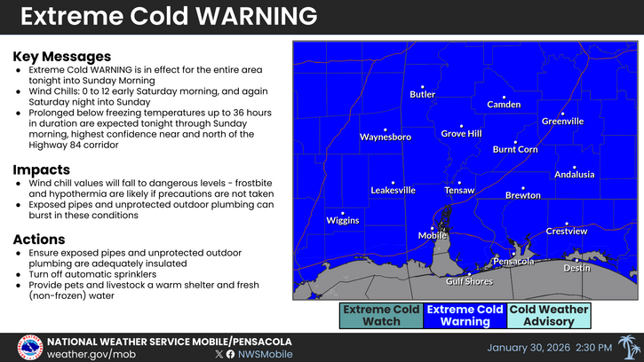
An Extreme Cold Warning goes into effect tonight and continues through Sunday morning. Wind chills will likely drop into the single digits for most areas tonight and Sat night. Wind chills during the day on Saturday will likely remain in the upper 10s to low 20s. pic.twitter.com/pfyvmX7ygQ
— NWS Mobile (@NWSMobile) January 30, 2026
