6:50AM May 6, 2026
SEVERE WEATHER RISK INLAND TODAY; RAIN & STORMS LOCALLY THURSDAY MORNING… Severe thunderstorms, including a few tornadoes, will be possible today across parts of central and north Alabama and central Mississippi. Some of these storms may be problematic for parts of southwest Alabama later tonight. Folks in inland areas north of US84 and west of I-65 (places like Thomasville, Jackson, Grove Hill, Monroeville, Camden, Chatom, Gilbertown, Butler, and Sweet Water) should pay careful attention to any storms that develop this evening into tonight as tornadoes are most likely locally in those zones. We do have a low-end, Level 1 (out of 5) severe weather risk for much of the local area tomorrow (Thursday) morning as storms roll through from north and south. In addition to the risk of a few strong to severe storms tomorrow morning, our region will also receive quite a bit of beneficial rain. Multiple rain chances are expected tomorrow through Sunday. While it doesn’t look like an “all day washout” on Saturday or on Sunday, we will have scattered showers and storms around.
LEVEL 3 (OUT OF 5) TORNADO RISK TO OUR NORTH TODAY… Tornadoes, including the potential for a few EF2+ tornadoes, will be possible today across portions of central and north Alabama. The Storm Prediction Center has a Level 3 (out of 5) enhanced severe weather risk in place for many communities in central Alabama and central Mississippi to account for this possibility. This heightened severe weather risk is in place for Birmingham, Tuscaloosa, Northport, Centreville, Hoover, Homewood, Leeds, Talladega, Clanton, Greensboro, Moundville, Eutaw, Livington, Aliceville, Jasper, and surrounding communities in central Alabama. Areas near Starkville, Madison, and Vicksburg are included in this Level 3 (out of 5) risk in central Mississippi. Surrounding the Level 3 risk, a Level 2 (out of 5) risk is in place for many more communities in central and north Alabama, including Florence, Muscle Shoals, Decatur, Huntsville, Gadsden, Cullman, Hamilton, Alexander City, Demopolis, Selma, and Butler.
SCATTERED SHOWERS POSSIBLE LOCALLY TODAY; SEVERE STORMS INLAND?… Spotty showers will be possible in the afternoon and evening hours across south Alabama and northwest Florida. There is a possibility that a few storms in parts of Washington, Monroe, Clarke, Choctaw, Wilcox, Marengo counties, along with points to the north and west, could have severe weather issues as we get into this evening and tonight. We encourage everyone to have multiple ways to get urgent weather warnings throughout the day and into tonight.
SEVERE WEATHER TIMING – THURSDAY… 5AM to Noon on Thursday is the main window for strong to severe thunderstorms across south Alabama and northwest Florida. Storms will probably be weakening while crossing our region from north to south, thus the first 3-4 hours of the window (5AM to 9AM) are probably when storms will be strongest. Severe storms will be possible to our north (in portions of north and central Alabama) during the daytime hours today into tonight.
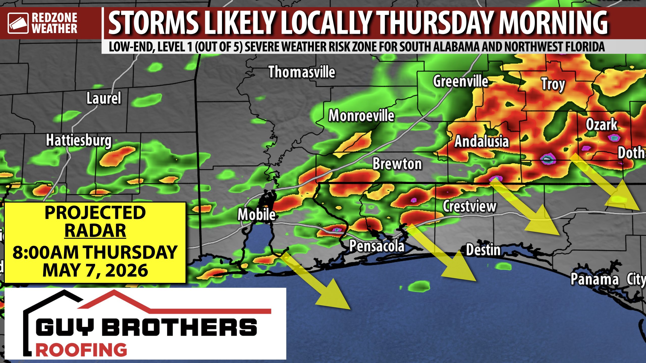
LOW-END, LEVEL 1 (OUT OF 5) SEVERE WEATHER RISK THURSDAY MORNING… Most of the storms that will move through the local area tomorrow morning will probably remain below severe limits. Thunderstorms will likely be moving into the northern fringes of south Alabama by 5-6AM Thursday morning. Some of these storms may be producing gusty winds capable of knocking down a few trees. The overall tornado risk remains LOW, but not zero. Storms will move from northwest to southeast. I expect storms to be arriving in northwest Florida by 7-8AM with storms reaching the coast by 9-11AM.
SPOTTY STORMS POSSIBLE FRIDAY INTO SATURDAY… 1-3″ of rain, in total, are expected over the next 5 days. We have multiple rain chances into the weekend that should help to continue alleviating drought conditions. Scattered showers and thunderstorms will be possible Friday, Saturday, and into Sunday as well. There is a chance that a few thunderstorms on Sunday could be strong or marginally severe. Drier weather returns around Tuesday of the upcoming week.
APP… If you haven’t already downloaded the RedZone Weather app, now is a great time to do that. redzoneweather.com/app is the link to the free download. Once you have the RZW app installed on your iOS or Android device, be sure to visit the Alerts tab to turn on the specific notifications you’d like to receive. All notifications are handcrafted by me. No automation and we promise not to bug you!
See all the details in your Wednesday RedZone Weather forecast video. My next forecast video will be posted by 7:15AM tomorrow morning. I will have updates posted throughout the day, as needed, in the RedZone Weather app.
Have a nice Wednesday!