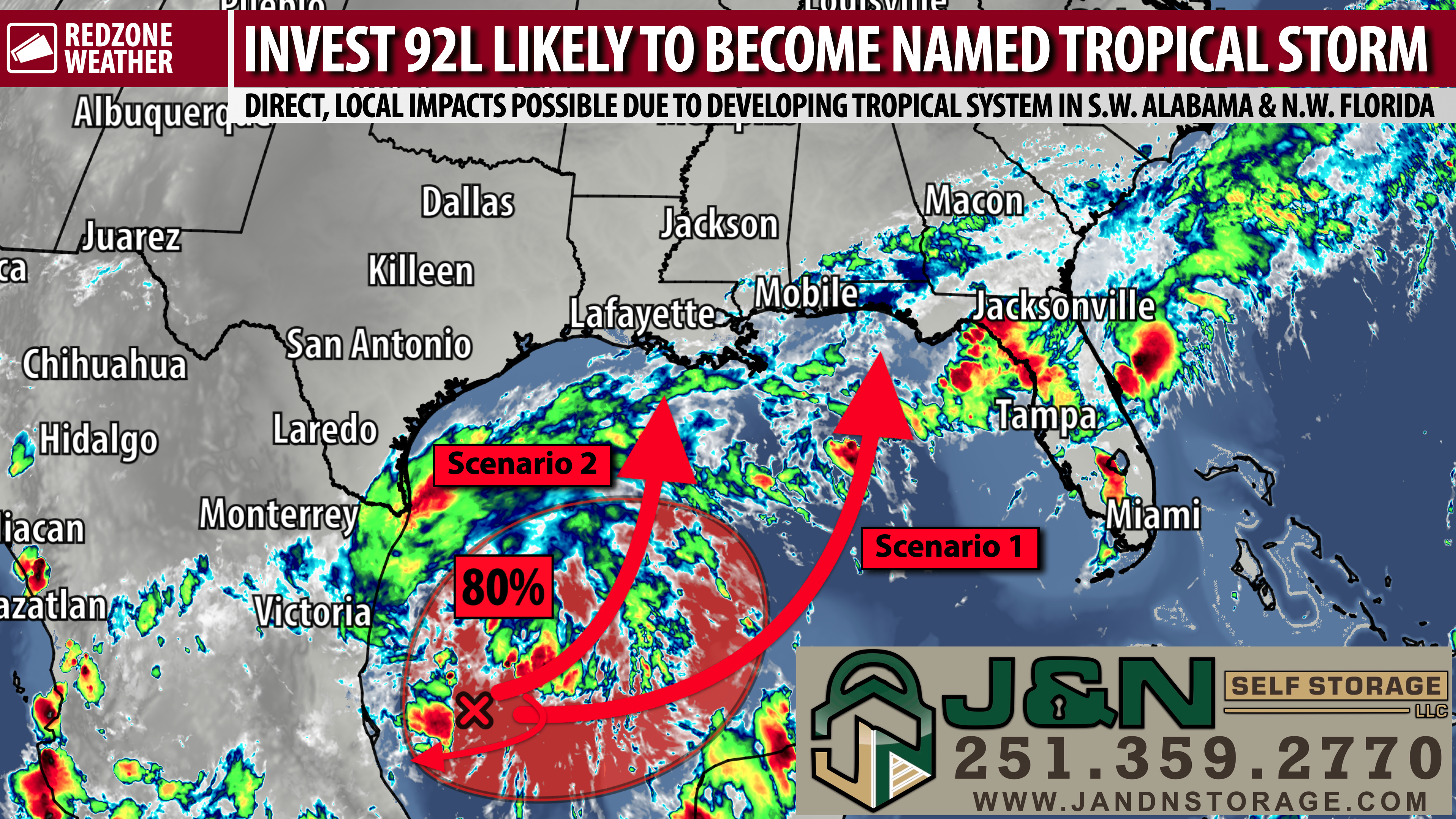
PARTLY CLOUDY TUESDAY; TROPICAL STORM LIKELY TO DEVELOP IN GULF AND MOVE NORTH INTO WEEKEND… We’re keeping a close eye on INVEST 92L, the disturbance located in the southwestern Gulf that is expected to become a named tropical storm in the days ahead. Other than a few showers, big weather impacts are not expected today across south Alabama and northwest Florida. A mix of clouds and sunshine is expected across south Alabama and northwest Florida today, with a few showers possible, particularly closer to the coast. Rain chances are much lower farther inland near places like Thomasville and Greenville. High temperatures will be in the upper 70s to low 80s, with occasionally breezy conditions. We’ll be watching the tropical disturbance in the Gulf over the next few days as The National Hurricane Center indicates an 80% chance of development into a named tropical storm. The system is forecast to drift eastward initially before turning northward. It remains too early to pinpoint where it will ultimately go or how strong it may become. Local impacts in Alabama and northwest Florida are increasingly likely, regardless of whether the system takes a name or not.
POTENTIAL LOCAL IMPACTS FROM INVEST 92L – SOUTH ALABAMA & N.W. FLORIDA… Heavy rainfall and dangerous beach conditions are the primary potential concerns right now for south Alabama and northwest Florida as we monitor INVEST 92L. These hazards will likely happen regardless of whether the disturbance becomes a named tropical storm. Increasing rain chances later this week are more certain than the details of the system’s eventual track and strength. It is too early to make a specific local wind or tornado hazard assessment.
POTENTIAL LOCAL IMPACTS – ALABAMA & N.W. FLORIDA… Since we are still 4-5 days out from potential impacts due to this tropical system, it’s important for me to stress that CHANGES will be likely in the days ahead. The storm hasn’t even formed yet, so it’s impossible to nail down what to expect for specific communities just yet. Let’s break this down into what is likely, what is possible, and what (at the moment, anyway) seems unlikely.
LIKELY LOCAL IMPACT – RAIN… Rain is expected in the next week, specifically Friday and after. The latest QPF (Quantitative Precipitation Forecast) indicates nearly all of us across south Alabama and northwest Florida should expect upwards of 3 inches of rain (at minimum) before all is said and done around a week from today. Locales closer to the coast may have upwards of 5-8″ of rain in total (on top of what happened over the last few days). If we see this become a stronger system, those rain projection totals will have to be revised upward. For now, 3-5″ of total rain with the greater values near the coast is what I have in the forecast.
LIKELY LOCAL IMPACT – BEACHES… High surf, dangerous rip currents, and (at minimum) minor coastal flooding are expected this weekend. If the system ends up being a bit stronger, coastal flooding and storm surge would be greater issues.
POSSIBLE LOCAL IMPACT – WIND & TORNADOES… We won’t have a good handle on this for a few days, but please know that IF the system ends up strengthening to tropical storm or hurricane status, there is a high chance we will have to contend with an extended duration of possible tornadoes AND potentially significant wind impacts, especially closer to the coast. Saturday through Monday A.M. would be the broad time frame with this – not saying it would last that long, but odds are if we have bigger impacts, it would exist in that window.
POSSIBLE LOCAL IMPACT – MORE SIGNIFICANT STORM SURGE… Just like the tornado/wind threat discussed above, we won’t have a good idea of the storm surge specifics until later this week. There is a chance, however, that if this developing storm reaches strong tropical storm or hurricane status, storm surge could become an issue. This will largely depend on the exact future track of the system as well. If we’re on the eastern side of the storm, that will be more problematic than if we end up on the west side (when water would be blown out of local bays into the Gulf).
MAINLY DRY WEDNESDAY AND THURSDAY… Tomorrow looks like the driest day of the week, with nearly all communities expected to remain rain-free. Most places should also stay dry Thursday, although a few showers become possible and rain chances increase somewhat Thursday night. High temperatures will be in the low to upper 80s tomorrow and Thursday. This mainly dry stretch comes before a more noticeable increase in rain coverage Friday into the weekend.
INCREASING RAIN CHANCES FRIDAY… Showers and a few thunderstorms become more likely Friday, with rain chances increasing further Friday night. High temperatures will generally be in the 80s. While the exact evolution of 92L remains uncertain, the local forecast already supports a wetter pattern as we head toward the weekend. We will be able to refine the timing and coverage of the rain as the disturbance becomes better organized.
IMPACTS FROM TROPICAL SYSTEM POSSIBLE SATURDAY INTO SUNDAY… Saturday and Sunday currently look like the wettest days of the next week. Rain chances will be high on both Saturday and Sunday, with showers and some thunderstorms likely. High temperatures will be in the upper 70s to low 80s. Heavy rain and hazardous surf remain the main concerns, but specific impacts from the tropical system will depend on its track and strength. An upper-level weather system moving toward Texas will help determine when and where the Gulf disturbance turns northward. Those details are not settled yet. If you have outdoor or beach plans this weekend, keep checking the forecast as confidence improves over the next few days.
BEACHES: RIP CURRENT WARNING… A HIGH risk of life-threatening rip currents begins today at the Alabama and northwest Florida beaches and is expected to persist through at least the remainder of the week. Stay out of the water while these dangerous conditions persist. High surf will also increasingly become a concern as the Gulf disturbance evolves over the next few days.
APP… Download the free RedZone Weather app at redzoneweather.com/app to keep up with the latest weather information for south Alabama and northwest Florida. Once you have the app installed, head over to the Alerts tab and select the notifications that are most useful to you. All notifications are handcrafted by me, and you remain in control of which alerts you receive.
See all the details in your Tuesday RedZone Weather forecast video. My next forecast video will be posted by 7:15AM tomorrow morning. I will have updates posted throughout the day, as needed, in the RedZone Weather app.
Have a good Tuesday!