
12:19AM September 21, 2026
RT @cyclonicwx: #Fay approached hurricane strength, but is just short. Shear is ramping up and the center looks to be exposed soon. Probabl…
— Spinks Megginson (@rzweather) September 21, 2026

RT @cyclonicwx: #Fay approached hurricane strength, but is just short. Shear is ramping up and the center looks to be exposed soon. Probabl…
— Spinks Megginson (@rzweather) September 21, 2026
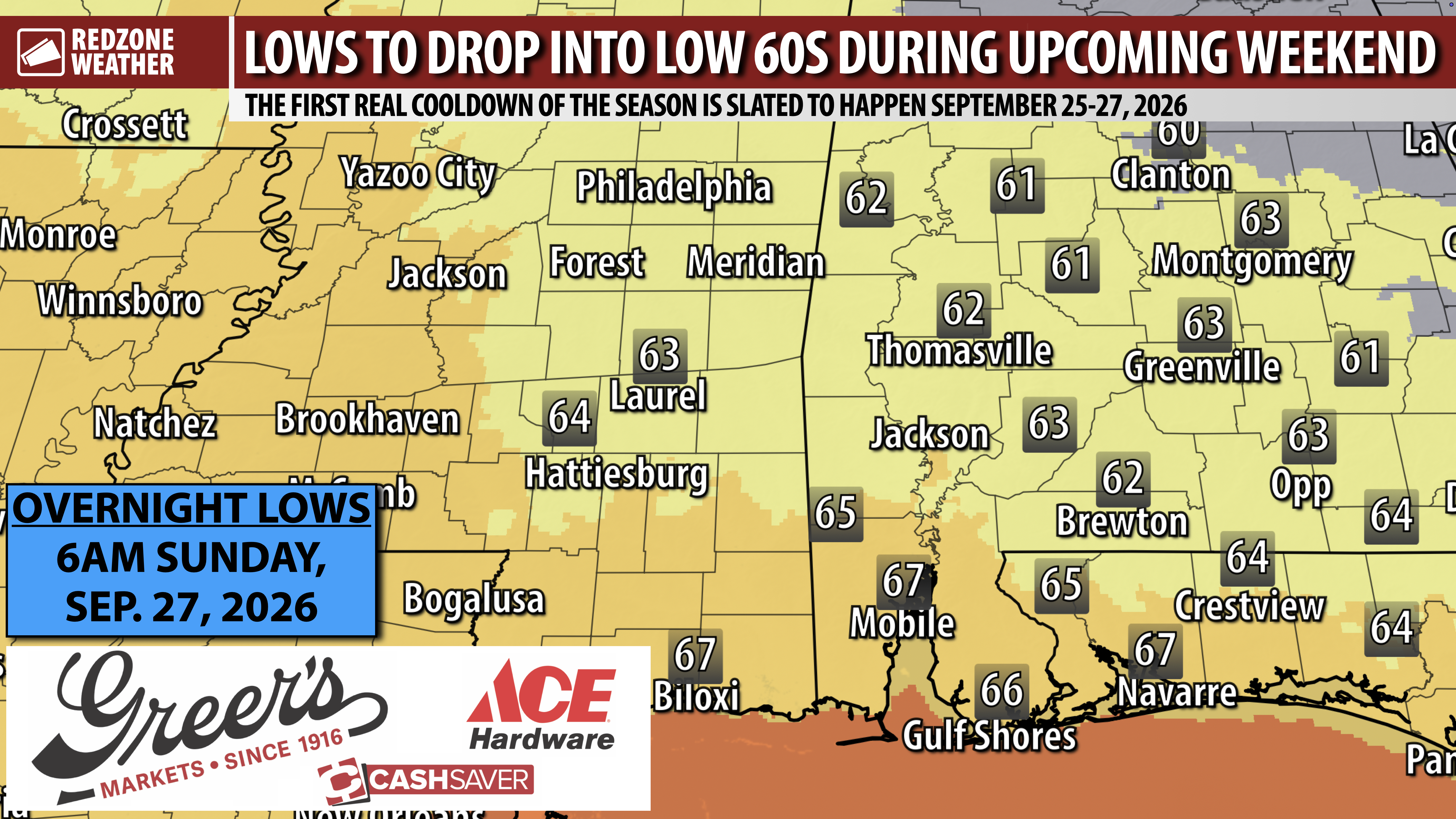
REAL SIGNS OF A COOLDOWN COMING AT THE END OF THE WEEK… I know this post will make a LOT of folks very happy! We are seeing consistent signs that the end of the week into the weekend will be SLIGHTLY less humid and notably cooler than the last few weeks. I expect overnight lows to be in the low 60s by the time we get into Saturday and Sunday of the upcoming weekend. A weak cold front will approach south Alabama and northwest Florida midweek with slightly cooler, slightly drier air moving in Thursday into Friday.
SUBTLE COOLDOWN… Don’t think it’s about to turn cold. It’s not. This will be more of a subtle drop in humidity during the day. Where the welcome changes will be most pronounced is in the overnight and early morning hours when lows will be in the low 60s inland with mid 60s at the coast. It will be pleasant this weekend. High temperatures will be in the 80s on Saturday and Sunday.
MORE POP-UP STORMS TOMORROW… We had multiple, quick-hitting severe storms this afternoon into this evening that produced several areas of hail along with gusty winds and localized downpours of rain. The lightning was prolific in some of the storms. I am expecting more of the same with mostly sunny skies tomorrow morning ahead of an afternoon and evening round of scattered storms.
I will have a full, detailed look at your forecast in the next regularly scheduled RedZone Weather forecast video that will be posted by 7:15AM tomorrow morning. Join me then for an in-depth look at the forecast.
APP… Download the free RedZone Weather app at redzoneweather.com/app to keep up with the latest weather information for south Alabama and northwest Florida. Once you have the app installed, head over to the Alerts tab and select the notifications that are most useful to you. All notifications are handcrafted by me, and you remain in control of which alerts you receive.
Have a nice Sunday evening!

REAL SIGNS OF A COOLDOWN COMING AT THE END OF THE WEEK… I know this post will make a LOT of folks very happy! We are seeing consistent signs that the end of the week into the weekend will be SLIGHTLY less humid and notably cooler than the last few weeks. I expect overnight lows https://t.co/W31RiqVcPV
— Spinks Megginson (@rzweather) September 21, 2026

Severe Thunderstorm Warning for Walton County in FL until 8:30pm.
— Spinks Megginson (@rzweather) September 21, 2026

Storms across Mobile County will continue to produce quite a bit of lightning while moving southwest. Loud storms near Downtown Mobile, Prichard, and Citronelle are producing heavy downpours of rain and lots of lightning.
Storms will gradually weaken over the next few hours. https://t.co/uU0CSM1AWx
— Spinks Megginson (@rzweather) September 21, 2026

Rain shaft moving into Orange Beach from the northeast. Thanks to Robyn Choiniere for the view! https://t.co/CP6op1MS0J
— Spinks Megginson (@rzweather) September 21, 2026

RT @unclehenry: Storm on Mobile Bay https://t.co/2DfrcmciFD
— Spinks Megginson (@rzweather) September 21, 2026
