6:54AM January 29, 2026

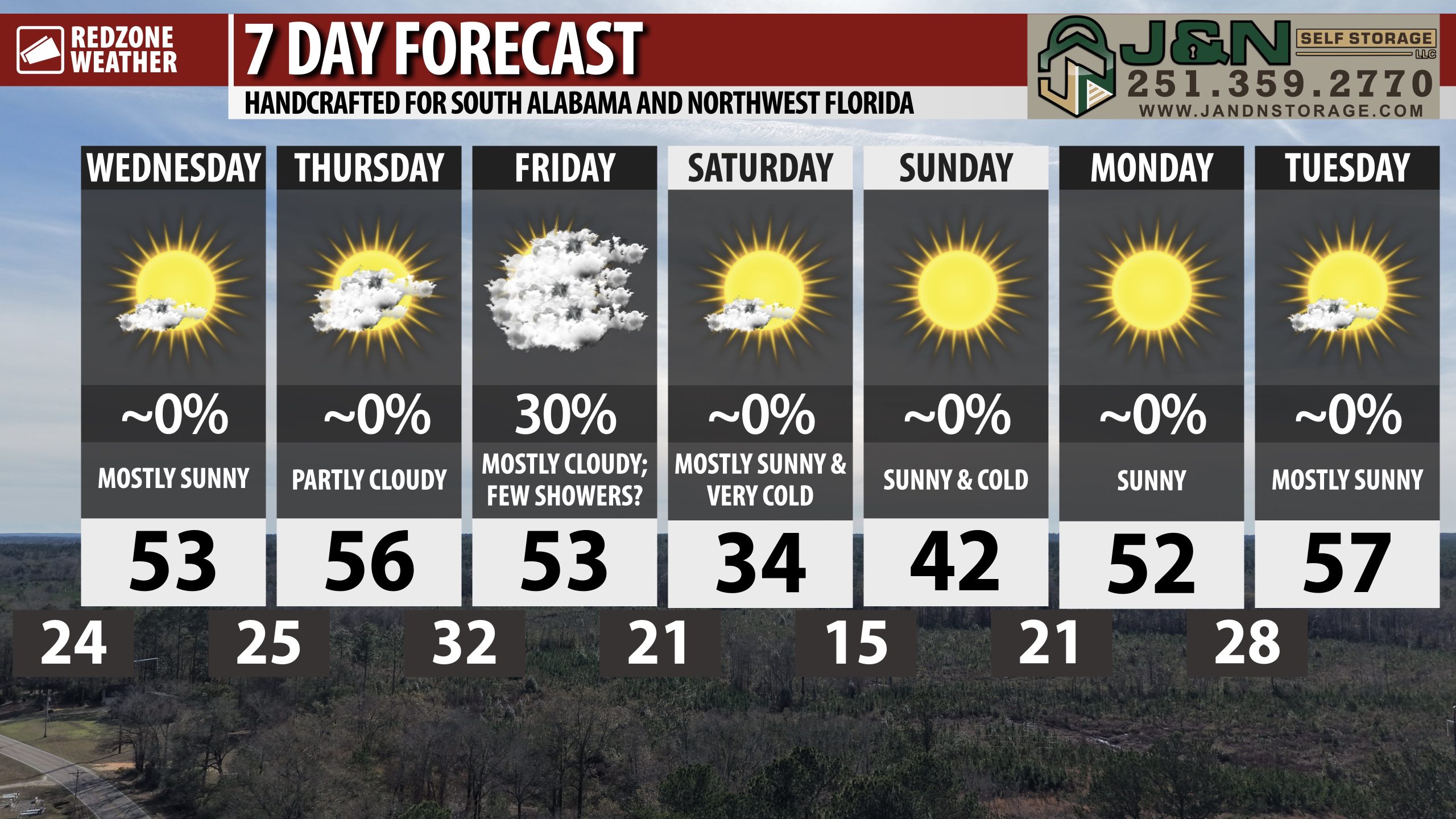
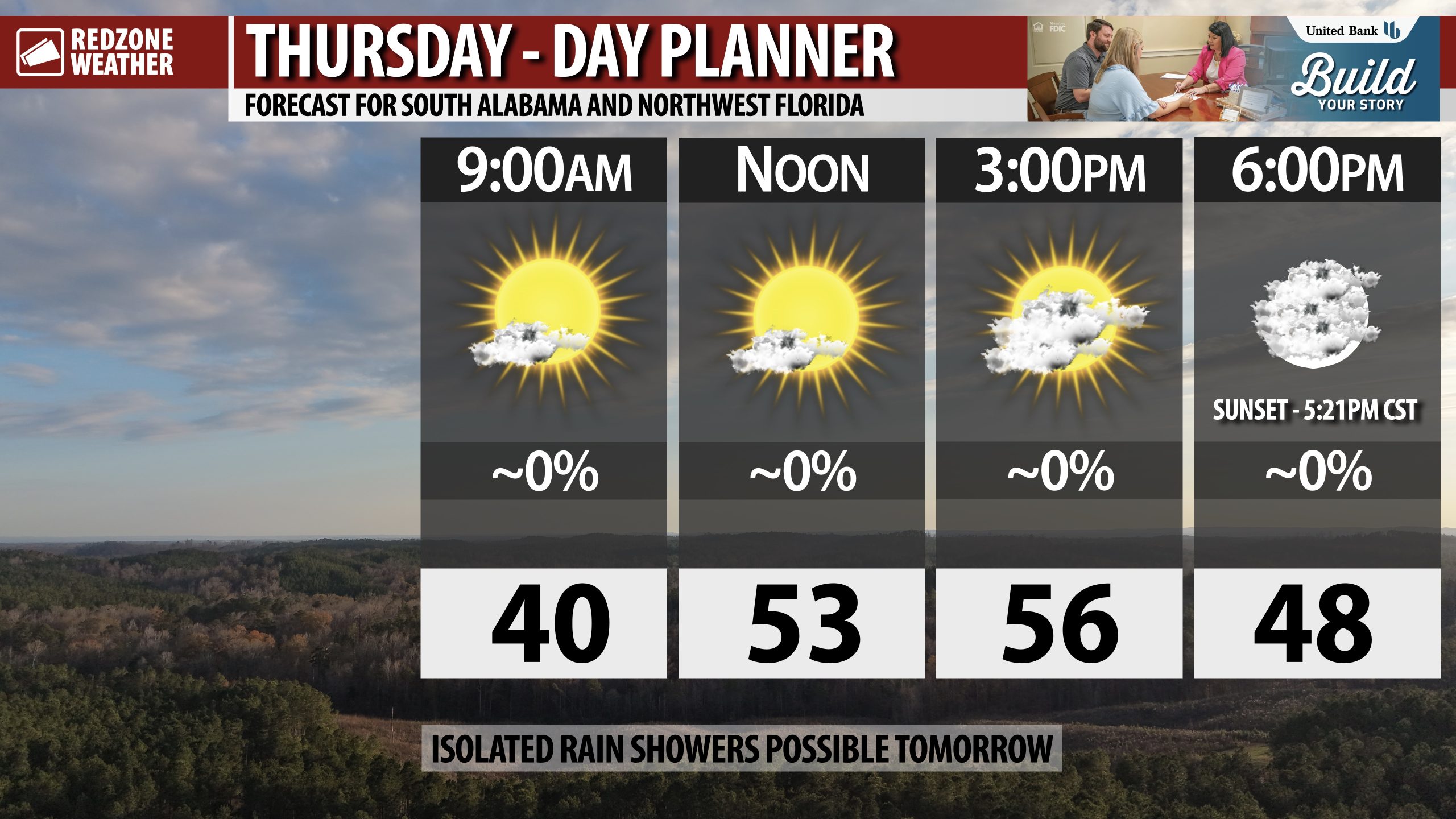
PARTLY CLOUDY THURSDAY; FEW RAIN SHOWERS FRIDAY… Skies will be partly cloudy on this Thursday with afternoon highs in the mid to upper 50s. We will have somewhat of a break from the Arctic deep freeze tonight. Some communities closer to the coast will remain above the freezing mark tonight. Tomorrow, isolated showers will become possible as an area of low pressure develops and moves across our area to the east. All of the showers will be in the form of rain as temperatures will be far too mild locally for any wintry precipitation. Very cold air moves in tomorrow night, long after the rain is gone. High temperatures on Saturday will struggle to get above the freezing mark. Cold temperatures persist into Sunday and Monday.

ISOLATED SHOWERS LOCALLY TOMORROW; FLURRIES WELL TO OUR NORTH… An area of low pressure that ultimately will become a powerful Nor’easter system on Sunday into Monday will move across our region on Friday. This feature will pave the way for a few widely scattered rain showers at times. Rain chances remain in the 20-30% chance range across the region. There is a good chance most communities remain completely dry tomorrow. Afternoon high temperatures on Friday will be in the upper 50s and perhaps even low 60s in some spots.

VERY COLD THIS WEEKEND… Very cold, dry air moves into south Alabama and northwest Florida on Friday night into early Saturday morning. Temperatures will be below freezing Saturday morning with wind chill values in the upper 10s. Afternoon HIGHS will struggle to get back to 32° on Saturday. Temperatures will be in the upper 10s and low 20s on Saturday night into Sunday morning. Wind chill values will likely be in the single digit range in many communities locally on Sunday morning.

DRY WEATHER SATURDAY, SUNDAY, INTO EARLY NEXT WEEK… Saturday, Sunday, Monday, and Tuesday will likely be dry, cold days. Highs on Sunday will be around the 40° mark with highs in the 50s on both Monday and Tuesday. No rain or precipitation is expected in that range.

EARLY SIGNS OF A WARMUP IN 8-10 DAYS… While it is impossible to be specific at this stage, consistent data across the major global weather models points to somewhat of a warmup expected to happen around February 8. That doesn’t mean it will be warm, far from it most likely, but we probably will have more seasonal temperatures with high temperatures in the 60s and lows in the upper 30s and 40s. The consistent shots of Arctic cold air may come to somewhat of a halt at that point.

APP… If you haven’t already downloaded the RedZone Weather app, now is a great time to do that. redzoneweather.com/app is the link to the free download. Once you have the RZW app installed on your iOS or Android device, be sure to visit the Alerts tab to turn on the specific notifications you’d like to receive. All notifications are handcrafted by me. No automation and we promise not to bug you!

See all the details in your Thursday RedZone Weather forecast video. My next forecast video will be posted by 7:15AM tomorrow morning. I will have updates posted throughout the day, as needed, in the RedZone Weather app.

I hope you have a great Thursday!

6:29AM January 29, 2026

PARTLY CLOUDY THIS AFTERNOON… Increasing cloudiness will happen this afternoon into this evening ahead of a chance of a few widely scattered rain showers locally on Friday.

Afternoon highs today will be in the mid 50s.

Have a great Thursday!

9:51PM January 28, 2026


8:11AM January 28, 2026

VERY COLD THIS WEEKEND… Our anomalously COLD pattern is set to continue this weekend into early next week with temperatures running about thirty degrees below our climatological norms on Saturday.

A few rain showers may become possible Friday ahead of very cold, dry air moving in on Saturday.

6:51AM January 28, 2026

COOL TEMPS TODAY; LOWS IN MID 20s THURSDAY MORNING; FEW RAIN SHOWERS FRIDAY… Clouds around this morning will give way to clearing skies in the afternoon and early evening hours. High temperatures will be in the low 50s across the entire region this afternoon. Sunset today happens at 5:20PM. Temperatures will quickly dive into the 30s around 8PM, falling to the 25-30° range for overnight lows by 6AM Thursday. A few rain showers may happen locally on Friday ahead of very cold, dry air returning for the weekend. This will be the coldest weekend we have had so far this winter season. Overnight lows will be in the 10s and low 20s with highs only in the mid 30s (!) on Saturday.

NEXT CHANCE OF RAIN: FRIDAY… Isolated rain showers will become possible late Thursday night (likely after midnight) into early Friday morning. Showers will be widely spaced and there is a real chance some communities remain completely dry. Any lingering rain showers will be gone by 6-7PM. Very cold, dry air will begin moving in Friday night.

VERY COLD TEMPS THIS WEEKEND… Cold, dry air moves in behind an advancing cold front Friday night. Overnight lows on Saturday morning will be in the upper 10s and low 20s with wind chill values in the single digits in many communities. Unfortunately, some communities will remain BELOW the freezing mark for afternoon highs on Saturday, particularly places near Alabama Highway 10 and points north. Most of us will peak in the 30-35° range on Saturday. That’s about 30 to 35 degrees below where we should be, climatologically speaking, for this time of year. Lows on Sunday will be in the 10s and low 20s again ahead of highs in the 40s Sunday afternoon. Sunny skies are expected Saturday and Sunday with no precipitation locally.

PRELIMINARY SIGNS OF SOMEWHAT OF A WARMUP IN 7-8 DAYS… Early model guidance is pointing to somewhat of a warmup in about 7-8 days. It won’t be warm by any stretch, but we are seeing the potential for high temperatures in the upper 50s and perhaps near the 60 degree mark by Tuesday and Wednesday of the upcoming week. Before we get there, we will go through an excruciatingly cold weekend with lows in the 10s. Thankfully, the horrendously cold weather we are having is not the norm for our region. High temperatures are normally in the 60s with lows in the 40s this time of year across our local area.

APP… If you haven’t already, be sure to download the free RedZone Weather app to keep up with all the latest information on the world of weather in south Alabama and northwest Florida. redzoneweather.com/app is the link for the free download. Once you have the app downloaded to your iOS or Android device, be sure to visit the Alerts tab (lower right corner) and tap the Alert Settings button to customize the alerts you would like to receive straight from me.

See all the details in your Wednesday morning RedZone Weather forecast video. My next forecast video will be posted by 7:15AM tomorrow morning. I will have updates posted throughout the day, as needed, in the RedZone Weather app.
Have a great Wednesday!