
9:18AM October 19, 2026
Zero rain is expected this week across much of the Deep South. https://t.co/Z8tnM6JG0d
— Spinks Megginson (@rzweather) October 19, 2026

Zero rain is expected this week across much of the Deep South. https://t.co/Z8tnM6JG0d
— Spinks Megginson (@rzweather) October 19, 2026
Picture perfect fall weather is ahead for the next 7 days!
There will be no Gulf tropical/hurricane issues this week. That is something we can all be thankful for. https://t.co/c7tUp2CJJ1
— Spinks Megginson (@rzweather) October 19, 2026

BEAUTIFUL FALL WEATHER THIS WEEK; GULF TO REMAIN QUIET THIS WEEK… Plenty of sunshine and comfortable afternoons are ahead across south Alabama and northwest Florida this week. High temperatures today will be in the 70-75° range with no rain expected. Temperatures will gradually https://t.co/O5KxnwoSRH
— Spinks Megginson (@rzweather) October 19, 2026

BEAUTIFUL FALL WEATHER THIS WEEK; GULF TO REMAIN QUIET THIS WEEK… Plenty of sunshine and comfortable afternoons are ahead across south Alabama and northwest Florida this week. High temperatures today will be in the 70-75° range with no rain expected. Temperatures will gradually warm over the next few days, but dry air will keep mornings chilly, particularly across inland communities. No tropical trouble or hurricanes are expected this week in the Gulf, despite prolific bad information circulating on social media over the last several days.
MOSTLY SUNNY SKIES IN EACH OF THE NEXT 5 DAYS… Mostly sunny skies are expected today through Friday as high pressure and a dry airmass remain in place. There simply will not be much moisture available to support rain. An upper-level disturbance will pass through the Deep South Wednesday night, but that feature is not expected to bring a meaningful change to our local weather. Passing clouds will be possible Wednesday into Wednesday night. Dry conditions are also forecast to continue into Saturday and Sunday.
HIGHS IN 70S; LOWS IN 40S IN DAYS AHEAD… High temperatures will rise into the low to mid 70s today, followed by mid to upper 70s tomorrow. By Wednesday, highs will reach the mid 70s to near 80°, with upper 70s to low 80s expected Thursday through the weekend. Overnight lows will fall into the 40s in the coolest inland communities, while warmer locations remain in the 50s and low to mid 60s. The dry air will allow a considerable temperature difference between the chilly mornings and warmer afternoons.
TROPICS: GULF REMAINS QUIET; RIP CURRENTS POSSIBLE AT BEACHES… No tropical disturbances are currently highlighted in the Gulf, but quiet tropical conditions do not mean calm water. A High Risk of dangerous rip currents continues through tonight at Alabama and northwest Florida beaches. Please stay out of the Gulf while these conditions persist. Strong northeast winds will also maintain hazardous conditions for mariners over the Gulf and area bays and sounds. The rip current risk is expected to decrease Tuesday.
TROPICS: SUBTROPICAL LOW EAST OF VIRGINIA IN ATLANTIC… The National Hurricane Center is monitoring the potential for subtropical development associated with a non-tropical low off the U.S. East Coast. The system is expected to move slowly and erratically through the middle of this week, with a low (30%) chance of development over the next 7 days. Regardless of whether it acquires subtropical characteristics, high winds, coastal flooding, and dangerous surf are expected along portions of the U.S. East Coast. Those impacts will happen along the East Coast regardless of if the system becomes a named tropical storm.
TROPICS: CARIBBEAN AND CENTRAL ATLANTIC QUIET… The National Hurricane Center is not highlighting any tropical disturbances in the Caribbean Sea or central Atlantic Ocean at this point. The 2026 Atlantic Hurricane Season will end on November 30.
APP… If you’re not already using the RedZone Weather app, you can download it for free at redzoneweather.com/app. I post brief weather updates in the app throughout the day, as needed. Be sure to visit the Alerts tab after downloading the app so you can select the specific notifications you’d like to receive.
See all the details in your Monday RedZone Weather forecast video. My next forecast video will be posted by 7:15AM tomorrow morning. I will have updates posted throughout the day, as needed, in the RedZone Weather app.
Have a wonderful start to your week!

Beautiful weather is expected across south Alabama and northwest Florida on this Monday. High temperatures will be in the low 70s.
Enjoy the day! 🌤️ https://t.co/cIleM420Mn
— Spinks Megginson (@rzweather) October 19, 2026

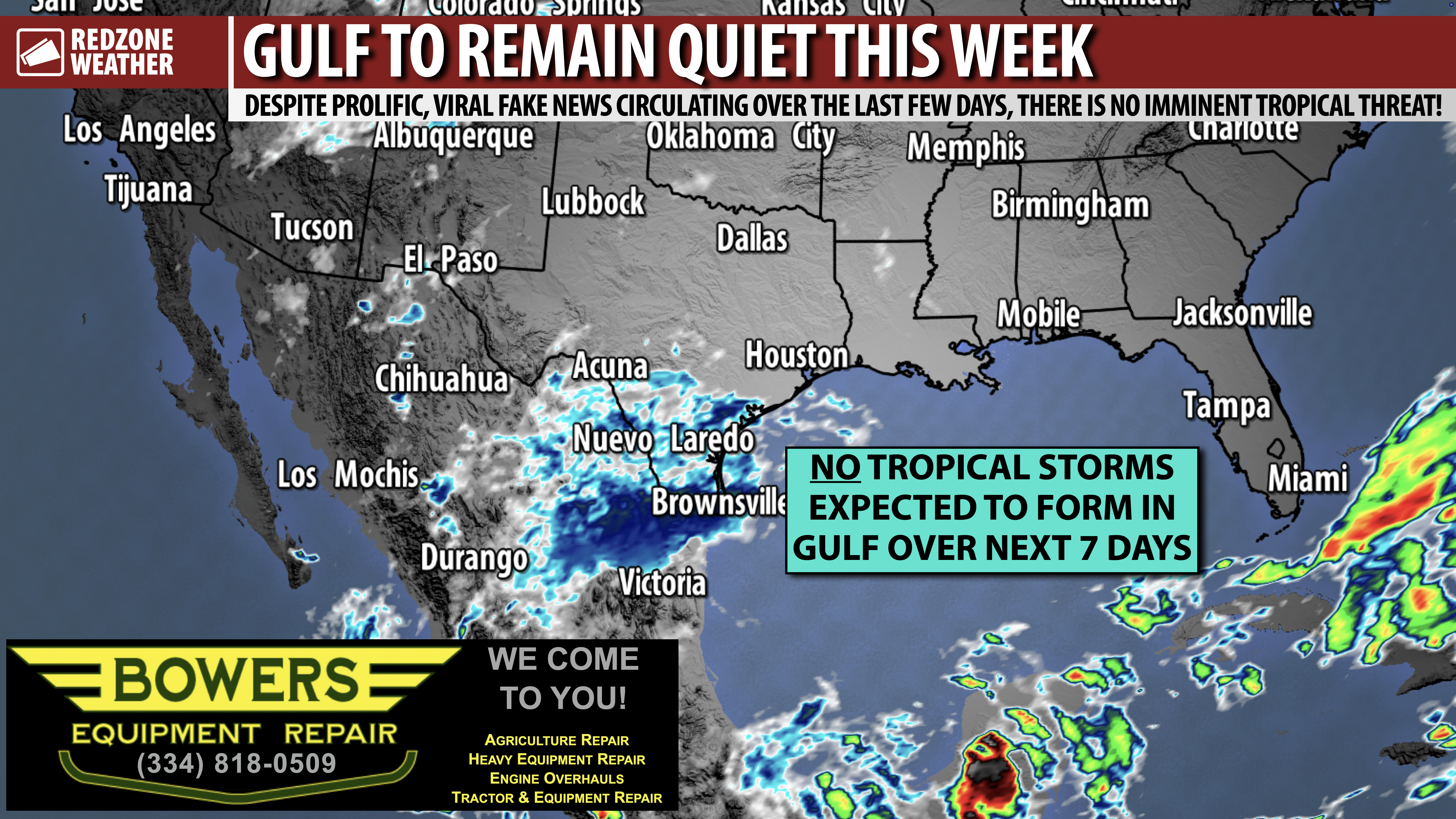
NICE WEATHER LOCALLY THIS WEEK; BEST OF ALL: GULF TO REMAIN QUIET… No tropical storms or hurricanes are forecast to happen in the Gulf or Caribbean Sea this week. I was inundated with questions over the last 3-4 days from concerned folks across our region who took a direct hit from Hurricane Isaias just over a week ago. Thankfully, we have zero concerns about a new tropical storm developing in the Gulf or Caribbean Sea over the next several days. The National Hurricane Center is watching an area of disturbed weather east of Virginia and North Carolina in the Atlantic Ocean, but that system will never directly affect northwest Florida, Alabama, Mississippi, Louisiana, or Texas.
QUESTION YOUR SOURCES… If you ever have a question about something you see on social media pertaining to weather, don’t hesitate to ask me. I’m glad to help. One viral post that was posted late last week was from a non-credible weather source. I don’t really know or understand what makes people want to post bad information instead of seeking the truth, but around here, we pride ourselves on making sure folks understand that I (nor anyone else!) can’t predict weather patterns with precision beyond 7 days out. I know with the advancements in technology, we will get there in the years ahead, but that day is not today. You can sometimes see patterns in the 7-10 day range, but even that gets murky a lot of the time.
SUNSHINE OVER THE NEXT FEW DAYS… Mostly sunny skies are in the forecast for Monday. A few passing clouds may be possible tomorrow morning but most of us will have a completely clear sky with highs in the 70s.
APP… Be sure to have the free RedZone Weather app installed on your phone to keep up with the latest weather information across south Alabama and northwest Florida. redzoneweather.com/app is the link for the free download. After installing the app, visit the Alerts tab to choose exactly which notifications you’d like to receive.
My next forecast video will be posted by 7:15AM tomorrow morning with the latest information.
Have a good Sunday night!

NICE WEATHER LOCALLY THIS WEEK; BEST OF ALL: GULF TO REMAIN QUIET… No tropical storms or hurricanes are forecast to happen in the Gulf or Caribbean Sea this week. I was inundated with questions over the last 3-4 days from concerned folks across our region who took a direct hit https://t.co/z2O1Vj13Tg
— Spinks Megginson (@rzweather) October 19, 2026
