RAIN TONIGHT; RAIN AGAIN SAT. NIGHT WITH BRIEF CHANGEOVER TO SNOW POSSIBLE… Spotty areas of rain will be possible overnight tonight into early Saturday. There is no chance of snow tonight as temperatures will be way too warm – most spots will have overnight lows around 45 degrees on Saturday morning. Widespread thunderstorms are highly unlikely and no severe weather is expected. Rain clears out tomorrow morning, most likely, ahead of a lull in the rain activity around midday into the afternoon hours. Afternoon temperatures will be in the 50s and low 60s closer to the northwest Florida coast. Scattered rain showers return tomorrow evening. Colder air will begin filtering into our local area tomorrow night. There continues to be a brief window from roughly midnight to 6AM on Sunday morning when a few areas of flurries and/or snow showers may become possible across the region.
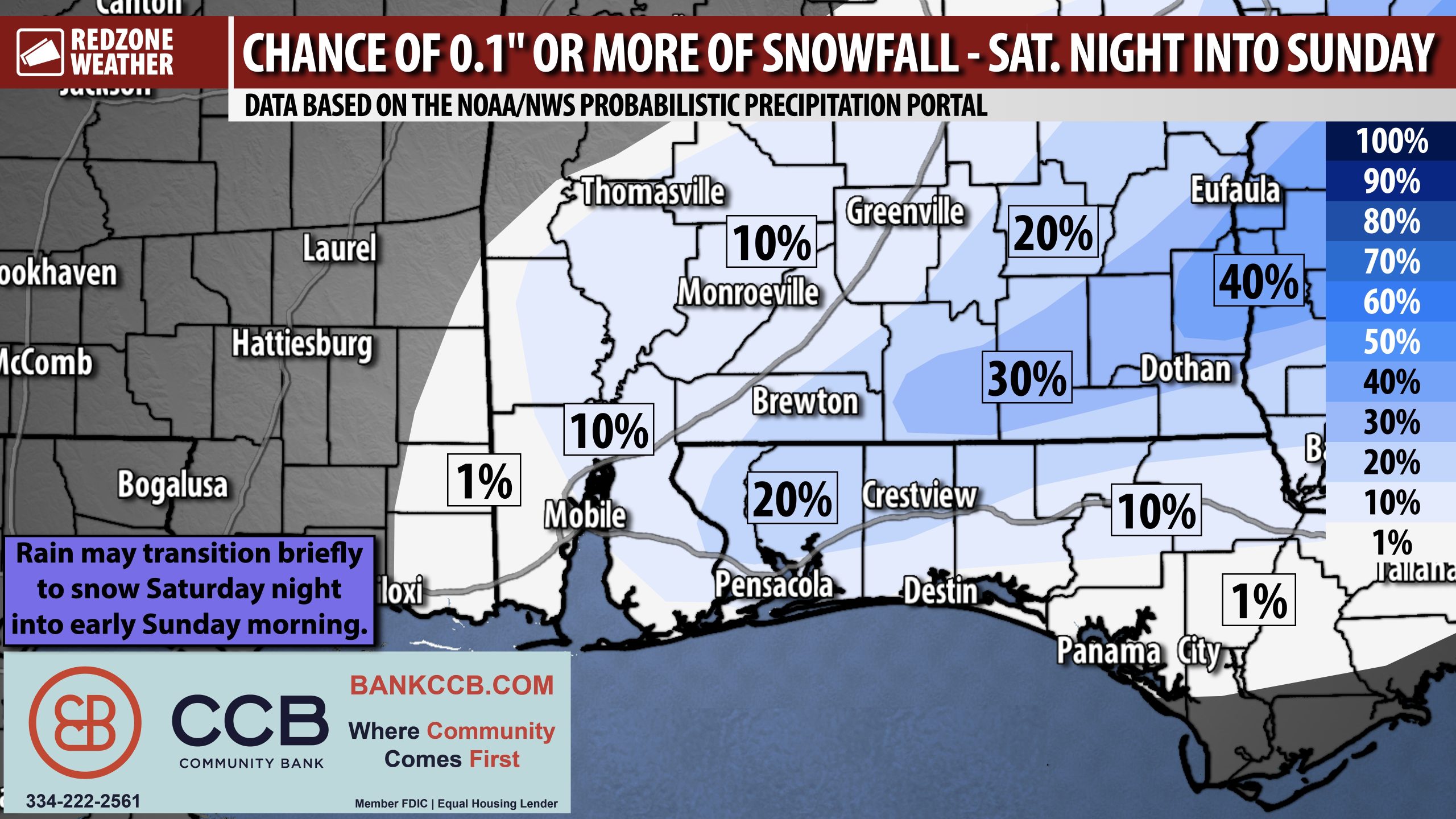
SO WHO GETS SNOW AND WHO DOESN’T?! If I’m being brutally honest, I imagine MOST communities will wake up Sunday morning to nothing but cold, wet grass. There may be some minor snow accumulation, particularly on elevated surfaces and bridges AND particularly in areas to our east. If I had to say what county is the most likely to get any snow, I would say Covington County, Alabama is the county in our local area where snow the most likely to happen, and even there, it’s HIGHLY questionable. You can see in the attached graphic that there is a narrow zone that extends from roughly Andalusia, Opp, and Florala back to Dothan and up to Abbeville and Eufaula that has a 30% chance of 0.1″ of accumulating snowfall. If you’re rooting for snow, even in that highest zone in our local area, those odds are not good. A 30% chance is not zero, however, and a range of outcomes exist.
SETTING EXPECTATIONS FOR TOMORROW NIGHT… I could write a long paragraph about this, but instead, let’s take it as some bite sized statements:
I will be NOT SURPRISED if the entire area simply has a cold rain tomorrow night into Sunday with not much else. I also wouldn’t be surprised if some communities had upwards of 0.25″ of snow on the ground Sunday morning with an isolated report here and there of 0.5″ of snowfall. These are the expectations for the event.
I will be A BIT SURPRISED if we have many communities with 0.5″ of snow on the ground Sunday morning.
I will be *EXTREMELY* SURPRISED if we have a large swath of communities with an inch of snow on the ground after the event.
I would be ABSOLUTELY FLOORED if we have ANY communities have over 3″ of total snow. This is the level of surprise I had last year when some communities reported almost a foot of snow. I can’t imagine being this surprised again, so soon, after what happened last year in the historic Blizzard of January 2025.
TRAVEL IMPACTS & ROAD CONDITIONS… The greatest potential for accumulating snow will happen across inland areas of southeast Alabama, although there is a real chance that even in that zone, precipitation happens in the form of rain exclusively. Slick spots on local roads will be possible from 10PM Saturday to 9AM Sunday, depending on if a specific location receives precipitation. Regardless of what happens specifically, I would go ahead and plan to stay where you are Sunday morning, at least through 9-10AM IF you’re a person who plans on the course of least regret. Even small amounts of snow can create very slick spots on local roadways. I would imagine if you’re headed out to a morning worship service Sunday morning after 10AM, you will be in good shape across the vast majority of our local area. The reason for this is temperatures will rapidly climb above freezing Sunday morning after 7-8AM. This will help to mitigate more widespread, major travel issues.
APP… If you haven’t already downloaded the RedZone Weather app, now is a great time to do that. redzoneweather.com/app is the link to the free download. Once you have the RZW app installed on your iOS or Android device, be sure to visit the Alerts tab to turn on the specific notifications you’d like to receive. All notifications are handcrafted by me. No automation and we promise not to bug you!
I will have the latest forecast rundown posted in the morning forecast video tomorrow morning at 7:15AM. Be sure to join me then for the latest info.
Have a fantastic Friday evening!
