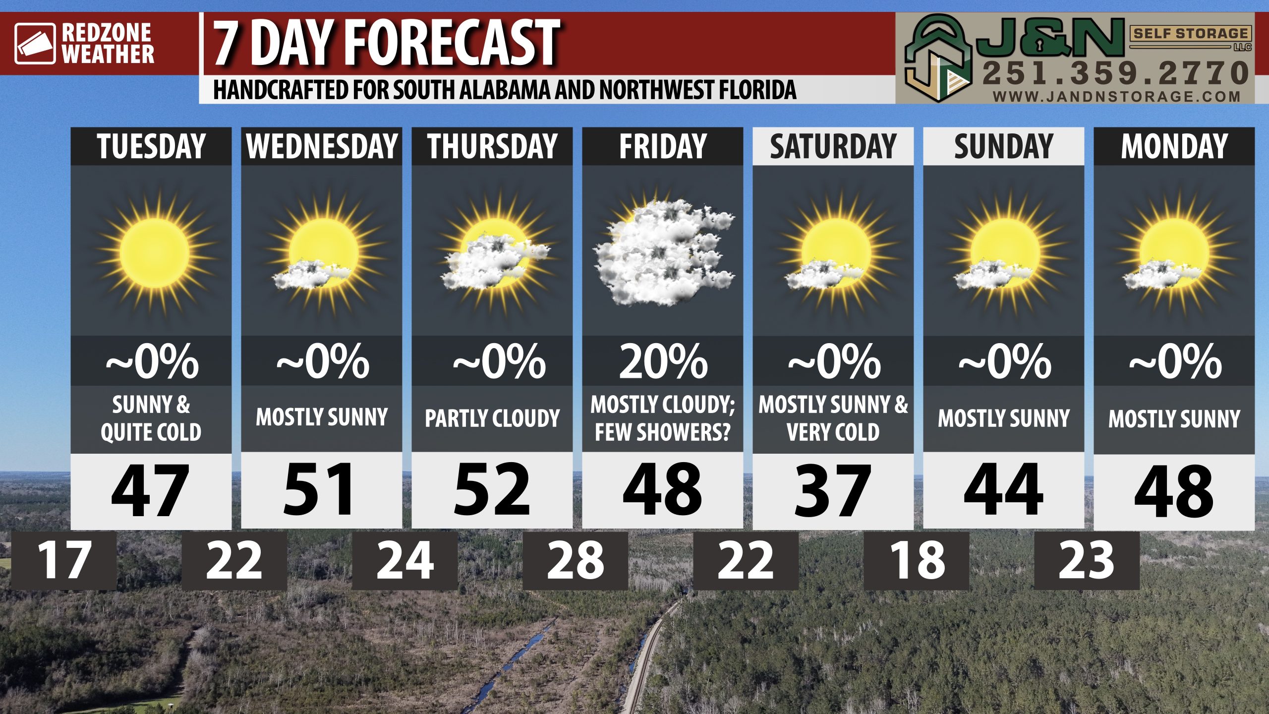
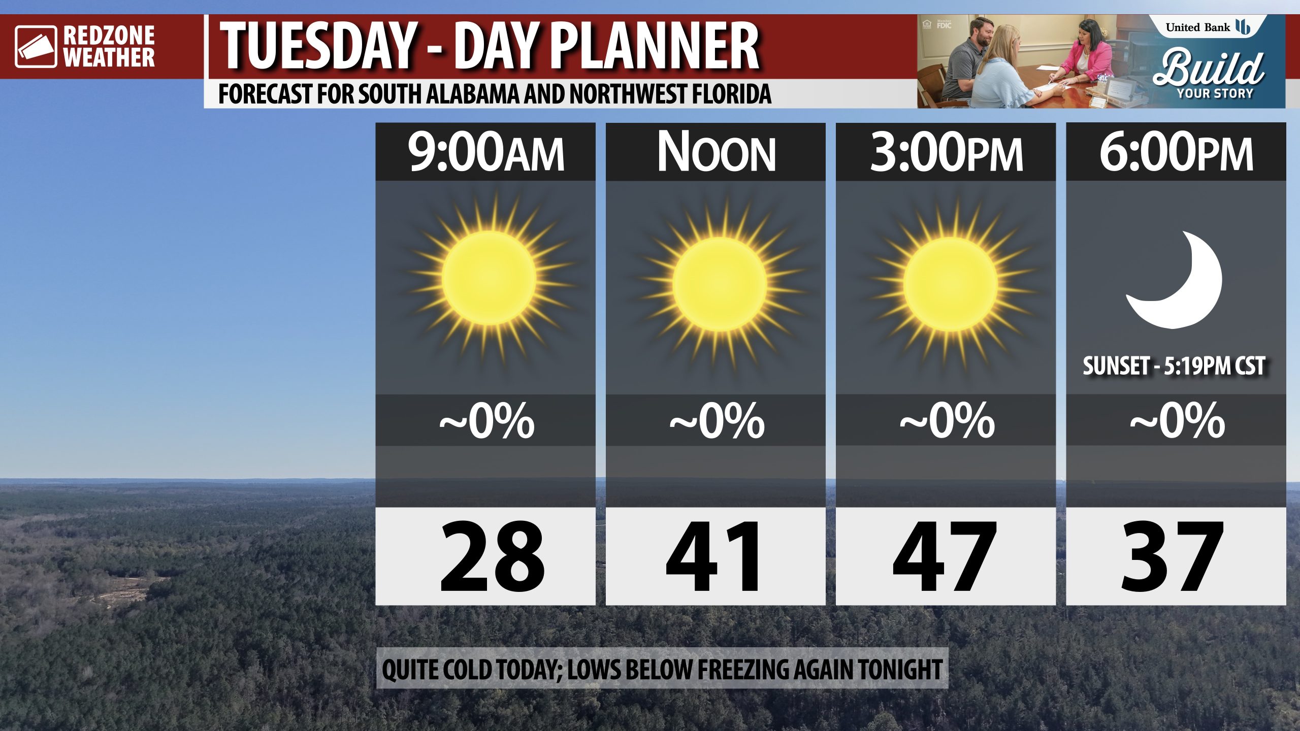
6:53AM October 10, 2025
FANTASTIC WEATHER TODAY AND THRU THE WEEKEND; COOLER TEMPERATURES… Beautiful, cooler weather will happen today and through the weekend across the region now that a cold front has pushed through. Afternoon high temperatures on this Friday will be in the upper 70s and near the 80 degree mark. Temperatures will be in the 60s if you’re headed out on the town this evening. Overnight lows by 6AM Saturday will be in the mid 50s in many spots, particularly north of U.S. Highway 84 with 60s likely closer to the coast. The weather pattern across the region this weekend will be picture perfect with highs near 80 and morning lows in the 50s.
PERFECT WEATHER FOR HIGH SCHOOL FOOTBALL THIS EVENING… Temperatures will be in the 60s for many of the high school football games across south Alabama and northwest Florida this evening. Dry, nice conditions are expected across the region with no rain.
BEAUTIFUL WEATHER THIS WEEKEND AND INTO NEXT WEEK… Temperatures will increase progressively as we get into next week. We’ll start the week with highs in the low to mid 80s. By the end of next week, however, high temperatures will be around the 90 degree mark yet again. Overnight lows will be in the 50s and 60s early next week. No rain in the forecast across south Alabama and northwest Florida from Monday through Thursday.
TROPICS: TROPICAL STORM JERRY NEAR THE LESSER ANTILLES… Tropical storm warnings continue for several of the northernmost Lesser Antilles due to Tropical Storm Jerry passing by just to the northeast. Jerry will likely move north over the weekend and strengthen into a category 1 hurricane. The center of Jerry will likely pass just southeast of Bermuda on Sunday into Monday. Jerry will never be a direct concern for the continental United States, most likely, as the system is expected to turn eastward and move out to sea early next week.
TROPICS: SUBTROPICAL STORM KAREN NORTHERN ATLANTIC… A swirl of clouds located about 1900 miles east of Cape Cod, Massachusetts in the remote part of the northern Atlantic Ocean has briefly organized into a tropical storm, taking the name Karen. Subtropical Storm Karen remains weak but there is enough organization to warrant advisories by the National Hurricane Center. Karen will likely remain well away from land areas and weaken tomorrow.
TROPICS: GULF & CARIBBEAN QUIET, FOR NOW… Tropical storm formation is not expected across the Caribbean or the Gulf over the next 5-7 days. The 2025 Atlantic Hurricane Season will end on Sunday, November 30.
APP… If you haven’t already downloaded the RedZone Weather app, now is a great time to do that. redzoneweather.com/app is the link to the free download. Once you have the RZW app installed on your iOS or Android device, be sure to visit the Alerts tab to turn on the specific notifications you’d like to receive. All notifications are handcrafted by me. No automation and we promise not to bug you!
See all the details in your Friday morning RedZone Weather forecast video. My next forecast video will be posted by 7:15AM Monday morning. I will have updates posted throughout the weekend, as needed, in the RedZone Weather app.
6:28AM October 10, 2025

GORGEOUS WEATHER TODAY AND THIS WEEKEND… Fantastic weather is expected across south Alabama and northwest Florida on this Friday. High temperatures will be in the upper 70s and low 80s.
High school football games across the region will be dry tonight with temperatures in the 60s. Really feeling like fall!
Dry, nice weather will continue on Saturday and Sunday. Overnight lows tonight will be in the 50s inland with 60s near the coast.
12:59AM October 10, 2025
💨 1245am – It remains gusty along the coastline early this morning with several local sites gusting to 30mph over the past 1-2 hours. Winds will remain gusty at times through the overnight hours and into early Friday along the immediate coastline/beaches. #alwx #flwx
— NWS Mobile (@NWSMobile) October 10, 2025
10:57PM October 9, 2025
Subtropical Storm Karen has formed late this evening in the far northern Atlantic Ocean.
Karen is the northernmost forming system ever recorded in the Atlantic Basin.
The system won't affect land areas over the next day or so as it spins over the open ocean. pic.twitter.com/cXKE02S8Vs
— Spinks Megginson (@rzweather) October 10, 2025
9:28PM October 9, 2025
See that tiny swirl of clouds in the top right corner of the loop? There is a 60% chance that system briefly becomes a subtropical storm.
No threat to land. A mere curiosity at this point. pic.twitter.com/5xp5cl81xM
— Spinks Megginson (@rzweather) October 10, 2025
6:05PM October 9, 2025
Isolated showers near Pace, Floridatown, NAS Pensacola, Ft. Pickens, and Perdido Key are slowly drifting southwest. pic.twitter.com/IODNan5CMa
— Spinks Megginson (@rzweather) October 9, 2025


