6:49AM July 21, 2026
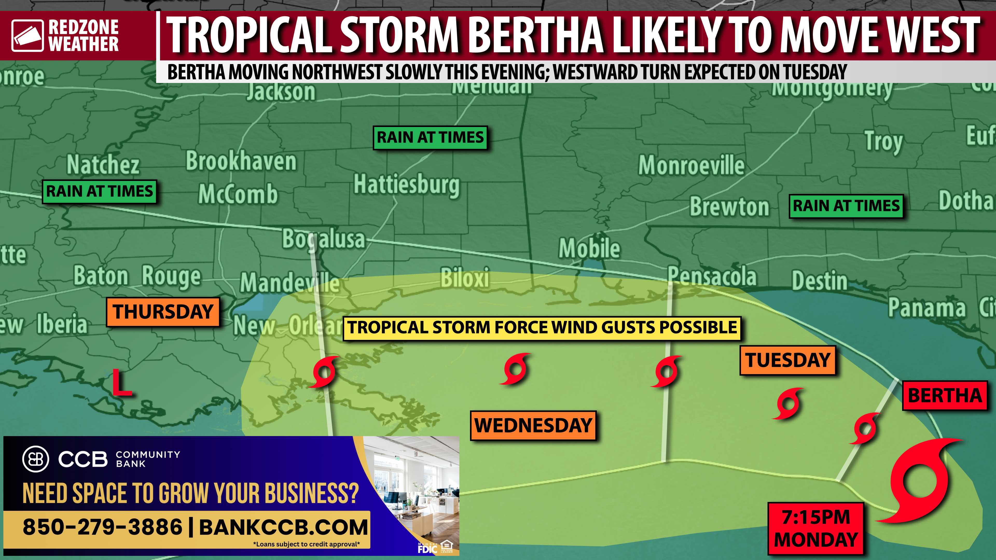
TROPICAL STORM BERTHA TO OUR SOUTH; SCATTERED STORMS TODAY LOCALLY… The disorganized core of Tropical Storm Bertha is passing to our south on this Tuesday. Landfall of the center of circulation is expected at some point tomorrow P.M. in eastern Louisiana, likely as a weak tropical storm or as a tropical depression. Locally today across south Alabama and northwest Florida, scattered showers and thunderstorms will be possible. Spotty storms may happen closer to the coast this morning before gradually building further inland this afternoon into this evening.
HOT & HUMID TODAY; HEAT INDEX VALUES AS HIGH AS 110°… There will be a gradient in place across the region in terms of temperatures, in this case with the hotter temperatures locally happening in west Alabama. Highs in the mid 90s are expected for places like Coffeeville, Chatom, Wilmer, and Bayou La Batre. Heat index values in these communities, closer to the Alabama-Mississippi state line, will be in the 105-110° range.
BERTHA LANDFALL EXPECTED TOMORROW IN EASTERN LOUISIANA… The official National Hurricane Center forecast for Tropical Storm Bertha brings the system into southeast Louisiana tomorrow evening as a tropical storm with maximum winds of 45-50 mph. Most of the rain and storms associated with the system will likely still be on the southern side of the system, meaning there is a real chance much of Louisiana won’t be dealing with major flooding issues due to Bertha.
LOCAL IMPACTS ASSESSMENT – ALABAMA & N.W. FLORIDA… Major impacts from Tropical Storm Bertha are not expected across south Alabama and northwest Florida. Slightly increased rain chances, in the form of scattered showers and storms, will happen on Tuesday and Wednesday. The greatest chances of rain will happen closer to the coast. The overall tornado risk is expected to remain quite low, but perhaps not entirely zero later this evening into Wednesday. For now, we note the Storm Prediction Center opted NOT to include any areas in a formal severe weather risk zone as the overall coverage of any tornadoes is expected to be very, very low. Coastal hazards, including rip currents, high waves, and minor storm surge will be possible through Wednesday. The National Hurricane Center includes all of the local coastline in the low-end storm surge zone where 1-3 feet of storm surge could be possible in isolated areas.
ONGOING SHEAR TO HELP LIMIT INTENSITY OF BERTHA… The latest guidance points to the bulk of the rain and thunderstorms associated with Tropical Storm Bertha remaining well offshore and south of the center of circulation. This is because the storm is “feeling the effects” of strong wind shear from the north. Usually in tropical systems, we see shear pushing convection to the east side of the storm, but in this case, the shear is working to our advantage by pushing the deeper thunderstorm action offshore and away from the coast. This is also the reason we will simply have spotty showers and storms today and not a long duration, widespread heavy rain.
TROPICAL STORM WATCH FOR LOCAL COAST… A Tropical Storm Watch is now in effect for coastal communities in Mobile, Baldwin, Escambia (FL), Santa Rosa, Okaloosa, and Walton counties. Basically, the communities south of I-10 nearer to the beaches are involved in the Tropical Storm Watch. Communities north of I-10 likely won’t be contending with tropical storm force wind gusts.
RAIN TOTALS DUE TO BERTHA GREATEST NEAR COAST… 1-2” of total rain will likely happen in most communities across south Alabama and northwest Florida in the days ahead, mainly driven by pop-up thunderstorms. Isolated higher rain amounts may be possible. Flash flooding may become a concern if storms train over the same areas, but the overall risk of flash flooding remains LOW. The more significant rain amounts are expected to happen offshore.
UPDATE ON LOCAL TORNADO RISK… If we have a tornado risk due to Tropical Storm Bertha, I expect it to begin this evening and continue into Wednesday as the core of Bertha passes to our south. The tornado risk, if one develops, would almost certainly happen in areas south of I-10 with a much lower risk further inland. It still is unclear if Bertha can sustain enough convection close to the coast to prompt a tornado risk, but that is something I will be monitoring throughout the day.
MINOR STORM SURGE POSSIBLE NEAR COAST… The National Hurricane Center indicates 1-3 feet of storm surge may become possible at the Alabama and northwest Florida beaches over the next 48 hours as the core of Bertha passes to our south. This is relatively minor storm surge and should not be a major problem for most communities. Rip currents will continue to be a problem later this week along with high waves.
TO CANCEL OR NOT TO CANCEL YOUR BEACH TRIP… I have been asked by many, many people over the last few days about whether or not they should cancel their south Alabama and northwest Florida beach vacation plans for the upcoming week. Everyone has a different risk tolerance. What I can tell you is we will have higher rain chances through Wednesday due to this system. Breezy conditions will be possible at the coast. Isolated tornadoes may be a problem midweek. The latter half of the week should feature much better weather with our normal, intermittent showers and storms each afternoon and evening. Would I cancel? No, but my general thinking is I would much rather be at the beach even during more inclement weather. You might cancel under the same set of circumstances.
TORNADO WARNING POLICY… Any time there is an active tornado warning in effect for southwest Alabama or northwest Florida, we provide uninterrupted, live video coverage on Facebook Live and YouTube Live. Our detailed coverage commitment is outlined at redzoneweather.com/coverage. We are proud to cover all parts of Escambia (AL), Covington, Monroe, Conecuh, Baldwin, Mobile, Clarke, Washington (AL), Butler, Escambia (FL), Santa Rosa, and Okaloosa counties. If you live in any locale in those counties, be sure to tune into our coverage whenever there is an active tornado warning!
APP ALERTS… redzoneweather.com/app is the link where you can download the free RedZone Weather app. We post brief updates throughout each day in the app, keeping you up-to-date about the latest happenings in weather across south Alabama and northwest Florida. Once you have the free app downloaded to your iOS or Android device, be sure to visit the Alerts tab (lower right corner) then tap the large Alert Settings button to customize the alerts you would like to receive straight from me.
See all the details in your Tuesday RedZone Weather forecast video. My next forecast video will be posted by 7:15AM tomorrow morning. I will have updates posted throughout the day, as needed, in the RedZone Weather app.
Have a good Tuesday!