9:31PM January 7, 2026
your 👏🏻 automatic lights 👏🏻 don’t always turn on 👏🏻 automatically.
Please make sure you turn your low beams on before heading out, please and thank you! https://t.co/UVAB3l5WWv
— Morgan ⚡️ (@jmorgan_wx) January 8, 2026

your 👏🏻 automatic lights 👏🏻 don’t always turn on 👏🏻 automatically.
Please make sure you turn your low beams on before heading out, please and thank you! https://t.co/UVAB3l5WWv
— Morgan ⚡️ (@jmorgan_wx) January 8, 2026
@NWSMobile @ThomasGeboyWX @WKRGEd @AlanSealls @spann @rzweather @GarofaloWX
Coden sunset pic.twitter.com/SiyfShzYNq— Jeremy Walker (@Jeremy_Walker5) January 8, 2026

Dense Fog Advisory will be in effect overnight into Thursday morning across much of the local area.
Mobile, Baldwin, Escambia (AL), Conecuh, Covington, Butler, and Crenshaw counties in south Alabama are included along with ALL of northwest Florida.
Take it slow if driving… pic.twitter.com/eMTxZpn1X9
— Spinks Megginson (@rzweather) January 7, 2026

Friday may feature a few strong to severe thunderstorms across parts of LA, AR, TN, MS, and northwest Alabama on Friday into Friday night.
Main concern will be gusty winds and large hail. A few tornadoes may become possible as well.
SW AL is involved in the lower-end, Level 1… pic.twitter.com/9efj3ETyIg
— Spinks Megginson (@rzweather) January 7, 2026

Mostly cloudy skies with temperatures in the mid 70s are happening across south Alabama and northwest Florida on this Wednesday.
Not expecting significant rain today. Sprinkles possible tomorrow at times ahead of higher rain chances on Saturday. pic.twitter.com/w2KjOkRQe1
— Spinks Megginson (@rzweather) January 7, 2026

The Storm Prediction Center has included much of northwest Alabama and Mississippi in their Level 2 (out of 5) severe weather risk zone valid for Friday into Friday night.
A low-end, Level 1 (out of 5) risk is in place for much of southwest Alabama.
Gusty winds, large hail, and… pic.twitter.com/mUN0JpJSrp
— Spinks Megginson (@rzweather) January 7, 2026

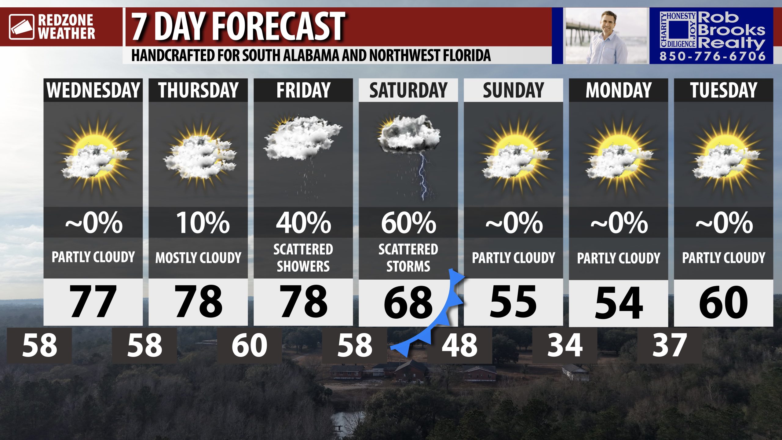
WARM TEMPS CONTINUE THRU FRIDAY… Afternoon high temperatures will continue to be in the 70s today, tomorrow, and Friday ahead of much cooler temperatures set to arrive next week after the passage of a cold front. Highs will be in the 50s on Monday!
